GeoComm’s GIS Data Hub is being used by more than 1,500 jurisdictions across the country as a part of their public safety GIS data management processes. The GeoComm Data Hub allows users to measure progress toward development and maintaining public safety grade GIS.
According to the company, the system quickly validates GIS data and related data against industry standards, as well as provides GIS data insights through quality control and reporting processes. The system allows GIS data organizers to work in their native data schemas and, upon submission, transform disparate GIS datasets into a common schema.
In addition, it aggregates multiple GIS datasets into a seamless coverage area, prepares map packages for provisioning to 911 applications, and leverages and extends the current Esri GIS data environment.
“GIS Data Hub is an integral part of our monthly processes,” said Vanessa Feagins, GIS supervisor, Denco Area 911 District. “It creates a central location for cities (with GIS departments) in our district to submit their GIS data which is then returned to our office as a single dataset. GIS Data Hub helps our office and our partner agencies identify possible errors in our datasets, which helps our district prepare for next generation 911 deployment. This would have been a difficult task without GIS Data Hub.”
Founded in 1995, GeoComm provides county governments with turnkey emergency 911 development services.
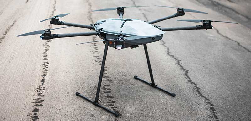
Fortem Technologies has completed the first phase of the U.S. Department of Transportation’s Unmanned Aircraft Systems Integration Pilot Program (UAS IPP) in North Carolina.
As part of the program, Fortem is conducting tests to monitor the airspace around WakeMed Hospital in Raleigh, tracking manned flights alongside the UPS Delivery Corridor, and delivering medical test samples via unmanned drones. Fortem has been using its TrueView radar and SkyDome software system to ensure UAS operations and drone deliveries do not interfere with medical helicopters flying in and out of the area, as well as alert drone operators of any potential non-cooperative aircraft in the vicinity.
According to the company, it was able to accurately and consistently track incoming medical helicopter traffic, providing real-time alerts to Airmap, an unmanned service supplier.
“By monitoring the airspace and creating a service that ensures the safe use of unmanned air vehicles, we will expand from these initial drone deliveries to greater geographical reach and more sophisticated roles for unmanned drones,” said Adam Robertson, CTO of Fortem Technologies. “With Fortem’s ability to offer real time data and analysis of airborne threats, we can start to see additional support for things like search and rescue operations, first responders, and increased shipments of critical supplies to remote locations. None of this can happen without the trust that our systems are effective and safe.”
The North Carolina Department of Transportation (NCDOT) Division of Aviation partners, including WakeMed Hospital, are testing drone operations that will soon go beyond a pilot’s visual line of sight to provide efficient and safe drone operations with the ultimate goal of helping to improve healthcare access for all North Carolinians.
“Ensuring the safety of manned aviation is paramount for unmanned flight operations, yet successful coordination of the two is not an easy task,” said Basil Yap, UAS program manager at NCDOT. “The phase one testing has shown promising results and we are hopeful the phase two operations will provide the information we need to receive a beyond-visual-line-of-sight waiver from the Federal Aviation Administration.”
Fortem will continue to provide situational awareness and secure the airspace into the next phase of the program, the company said. NCDOT, as part of the USDOT UAS IPP, will continue to support its partners’ operations at WakeMed throughout the year until the program’s conclusion in October.
GPS World is offering the latest news and updates concerning the coronavirus (COVID-19) pandemic as it affects the GNSS/PNT industry. Read a message from GPS World here.
Geospatial Solutions and GPS World are offering the latest news and updates concerning the coronavirus (COVID-19) pandemic as it affects the geospatial, mapping and GNSS/PNT industries. Read a message from GPS World here.
According to SDSN Trends, gridded population data have emerged as an important resource for delivering actionable data in challenging circumstances, including in disaster response and health and infectious disease monitoring. Gridded population maps distribute data using grid cells, combining census results with additional information, such as geospatial data from satellites.
The report presents an overview, analysis and recommendations for the use of gridded population datasets in a wide range of application areas, from health an infectious disease monitoring and disaster response to determining sea-level rise and future water availability.
The report compares seven gridded population datasets from the POPGRID Data Collaborative and presents an intercomparison assessment of the use of different datasets and their varying outputs. It also addresses misconceptions and offers nine guiding criteria to aid users in their selection process.
Trends is an initiative of and is governed by SDSN. Trends collaborates closely with SDSN’s network, including by seeking opportunities to work with its regional and national networks on local data action solutions and other projects.
The Federal Aviation Administration (FAA) and the Association for Unmanned Vehicle Systems International (AUVSI) will host the 5th annual FAA UAS Symposium virtually, rather than in-person in Baltimore. The event will take place June 16-18.
This decision was made as a result of the ongoing concerns caused by the COVID-19 pandemic, the organizers said.
The FAA and AUVSI also will be hosting a series of virtual events that will address the content already planned for this year’s program. The fist will take place in early summer and will focus on UTM and international UAS integration. The second will take place in late summer with a focus on updates to the Integration Pilot Program and public safety operations.
According to organizers, those registered for the 5th annual FAA UAS Symposium will receive a separate message in the coming weeks to confirm options for participation in the virtual events.
Those selected as speakers for the 5th annual FAA UAS Symposium will receive a separate message from AUVSI’s Industry Education Team to confirm participation, as well as any schedule changes.
Altitude Angel, a London, U.K.-based unmanned traffic management (UTM) technology provider, is releasing an open-sourced project, Scout.
Scout’s hardware and firmware enable drone manufacturers, software developers and commercial drone pilots to quickly connect to its global UTM.
Primarily intended for use in commercial and industrial drone applications, Scout provides the capability to securely obtain and broadcast a form of network remote ID, widely seen as a necessary step for enabling routine drone use and flights beyond visual line of sight.
Because it is open source, both the hardware and the firmware can be enhanced and incorporated into a virtually limitless set of scenarios, according to Altitude Angel.
Altitude Angel also has made available a surveillance API that allows integrators to both share and receive flight data from a variety of sensors and devices in near real time, providing a comprehensive real-time picture of the airspace.
While many remote ID systems are broadcast only, Scout offers two-way communication and is fully open-sourced. The ability to talk back to the drone enables the Altitude Angel UTM service to help the drone avoid collisions with other aerial vehicles, or restricted airspace.
From launch, Scout will use identifiers obtained freely from Altitude Angel’s GuardianUTM platform. It will work in combination with a pre-flight (flight-plan sharing) service and is supported through integration with Altitude Angel’s Tactical Conflict Resolution Service.
Scout will enable the drone to report its real-time location using GPS-type sensors and relay this data via a secure, encrypted mobile communications link across 3G, 4G and 5G networks to Altitude Angel. It is powered by an internal rechargeable (via micro USB) lithium battery.
Altitude Angel has also provided reference design plans for the case that can be 3D printed. Scout has been designed to satisfy emerging network remote ID standards, such as ASTM.
Because the firmware is open source, the telemetry can be sent to other systems as required by the implementor.
A two-wire I2C upgrade to the circuit schematics, plus version 2 of the firmware (both scheduled for June), will subsequently enable the full two-way communication between the Scout device and the drone’s onboard systems, allowing the drone to respond directly to information received from the UTM.
In the interim, early adopters will have the opportunity to begin to integrate with Altitude Angel’s UTM services, test the hardware and test communication. Position data Altitude Angel receives from Scout is then automatically used by its Flight Information Management System (FIMS) to help provide traffic deconfliction.
Plans, firmware and schematics can be accessed via the Altitude Angel GitHub repositories.
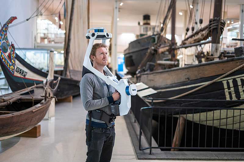
The all-in-one reality capture capabilities of NavVis VLX include both survey-grade point clouds and high-resolution panoramas. (Photo: NavVis)
NavVis has launched NavVis VLX, a wearable mapping system that captures high-quality data in built environments such as construction sites, staircases and small technical rooms.
The all-in-one reality capture capabilities of NavVis VLX include both survey-grade point clouds and high-resolution panoramas. The combination of high-quality data capture and a compact, economical design will transform the way architecture, engineering and construction (AEC) projects are captured with fast, efficient scanning for BIM and CAD applications, while also extending the scope of projects to new deliverables such as web-based digital twins, the company said.
NavVis VLX is equipped with two lidar sensors and captures survey-grade point clouds using the company’s SLAM technology, which was originally developed for the the NavVis M6 indoor mobile mapping system. NavVis VLX also captures high-resolution panorama images in a complete 360-degree field of view.
According to the company, this wearable device gives the operator more control over where the sensors are scanning. It also allows the user to view and interact with the built-in screen that provides live feedback of what has been scanned and the quality of the data being captured.
“We designed NavVis VLX to provide the AEC industry with a compact, versatile device that efficiently captures buildings and still delivers survey-grade point clouds,” said Georg Schroth, NavVis CTO. “Knowing that there is still an unmet need for high-quality mobile data capture in a wider range of building documentation applications, we set out to develop a more versatile device that can achieve what NavVis M6 does at a smaller scale and on a lower budget.”
According to NavVis, the data captured by the VLX can be applied to a wide range of applications, including conventional building documentation such as CAD drawings and BIM models, as well as to innovative digital twin solutions, such as NavVis IndoorViewer.
NavVis, headquartered in Munich, Germany, is a global provider of indoor spatial intelligence technology and solutions for enterprises. The company also has offices in New York and Shanghai.
The Institute of Navigation (ION) will be hosting a complimentary webinar, “Impact of Sample Correlation on SISRE Overbound for ARAIM,” at 12 p.m. ET on May 28.
This topic was originally presented at ION GNSS+ 2018 and published in the Spring 2020 issue of Navigation, Journal of the Institute of Navigation, Volume 67, No. 1, pp 197-212, by Dr. Santiago Perea Diaz, Prof. Michael Meurer and Dr. Boris Pervan.
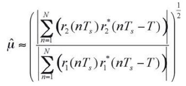
According to ION, this paper analyzes the effect of error correlation on the SISRE bounding for GPS and Galileo satellites. For a given period of data collection, it computes the effective number of independent samples contained in a dataset applying an estimation variance analyses. Results show that the time between effective independent samples is highly dependent on the constellation and onboard clock type. On one hand, GPS satellites equipped with Rubidium clocks exhibit significantly longer error correlation than those with onboard Cesium clocks. On the other hand, Galileo satellites show substantially shorter correlation time among samples with less variability on a monthly basis, ION added.
This paper also introduces a methodology to compute SISRE bounding accounting for the limited number of independent samples, ION said. Using a Bayesian approach, it computes the so-called uncertainty factor by which the Gaussian distribution needs to be inflated in order to account for the observation data independence.
Veripos has released the LD900, a quad-band GNSS receiver capable of tracking GPS, GLONASS, BeiDou, Galileo and QZSS constellations to provide reliable and accurate positioning. Access to multiple GNSS signals allow for better satellite availability and reduce the impact of satellite masking or blockage, which can affect positioning.
LD900 also receives L-band signals on multiple channels, providing access to the worldwide independent correction links and services provided by Veripos. With correction data available simultaneously from up to three correction satellites, the impact of satellite masking can be minimized to ensure reliable reception of correction data. Using the independent L-band RF input on the LD900 allows the connection of a dedicated L-band antenna ensuring optimal reception of correction services, especially at high latitudes, the company said.
Veripos provides accurate and reliable positioning for all marine applications via their redundant positioning and multi-frequency precise point positioning (PPP) Apex and Ultra services.
The Apex5 correction service utilizes all GNSS constellations delivering 5cm positioning accuracy for use in the most demanding offshore applications. Real-time kinematic (RTK) corrections can be utilized by the LD900 for applications where this service is required.
The intuitive color display and navigation menu makes setup, configuration and system status monitoring simple. The display also helps troubleshoot issues with the LD900 allowing faults to be quickly diagnosed and resolved. The LD900 can also be configured remotely through the Veripos Quantum software.
Features and Benefits
Supports decimeter-level multi-constellation positioning with Veripos Apex and Ultra PPP correction services
Multi-channel L-band allows simultaneous tracking of 3 Veripos correction service satellites
Independent L-band RF input
Easy-to-use, intuitive, color display for simple configuration and monitoring
Advanced signal filtering mitigates the effects of interference from other transmitters
Optional ALIGN GNSS heading solution
Optional MSK Beacon receives corrections from IALA marine radio beacon network
Automatic 72-hour rolling data log for incident support
The world so close has never seemed so far away. Locked up and adrift, somewhere between the comfort of the past and the anxiety of the future, the present slowly passes by in a procession of nameless days. The living room has become a sundial. Shadows pass from one wall in the morning to the far side by day’s end. Outside, spring has sprung, but inside, winter lingers on.
Alone, we can do so little. Together, we can do so much. —Helen Keller
Times like these, detached and disruptive, are opportunities in disguise. Ironically, while the world is confined and socially distanced from one another, humanity is more connected than it has ever been. Hard to believe, but smart mobile devices began just over a decade ago; and we are in the midst of a growing tsunami of connected devices, cloud computing, big data and open source. These events, coinciding with the exponential growth of geographic information systems and data analytics, have set the stage for crowdsourcing and citizen science. The era of empowering individual contributors has begun.
It has probably gone unnoticed due to all the political wrangling in Washington, D.C., but over the last two administrations, with bi-partisan support, without recognition or renown, a monument to American ingenuity was christened. Beginning in 2010, the America COMPETES Reauthorization Act was passed. Then, in 2014, the White House elevated homegrown inventors and creators calling it the Maker Movement and hosted the first-ever National Maker Faire. In 2015, the STEM Education Act became law and in the same year the Senate introduced The Crowdsourcing and Citizen Science Act. In 2017, the American Innovation Competitiveness Act became law formally coining the term, crowdsourcing. In 2019, the White House Office of Science and Technology Policy (OSTP) delivered the first-ever comprehensive report to Congress about federal agencies activities involving crowdsourcing and citizen science (FedCCS). Also in 2019, OSTP along with the General Services Administration (GSA) hosted the U.S. Government Open Innovation Summit.
The OSTP FedCCS report to Congress titled, “Implementation of Federal Prize and Citizen Science Authority,” cites 169 FedCCS prize competitions conducted by 18 federal agencies, such as the National Aeronautics and Space Administration (NASA), the Centers for Disease Control (CDC), and the National Institute of Science and Technology (NIST). However, the number of FedCCS projects is much greater than what is covered in the report. On Challenge.gov the amount of competitions rose from 744 in 2016 to 875 in 2018, and the prize awards ranged from $0 to $20 million with an average payout of $75,000 in FY2018. The next report is due in 2021.
Governments tapping into the resources of its citizens for innovation is not new, but it has never been on this scale and granted such authority. One of the first official attempts was the United Kingdom’s Longitude Prize in 1719 offering a King’s ransom of £20,000 [see article: From the Pyramids to GIS/GPS] to solve positioning at sea. Great Britain still honors the original Longitude Prize using the name for their national grand crowdsource competition. Similarly, in the United States the grand challenge is the X-Prize, the most famous one being the Ansari X prize. You may not know the prize by its name, but as NASA’s Space Shuttle Program phased down, the Ansari X-Prize kicked-off the space race among private companies. Scaled Composites won the $10 million prize in 2004 reaching space in a reusable craft, which became Virgin Galactic.
The term “crowdsourcing” means a method to obtain needed services, ideas, or content by soliciting voluntary contributions from a group of individuals or organizations, especially from an online community. —15 USC Chapter 63 §3724 (2): Crowdsourcing and Citizen Science
The U.S. Federal Government already relies on the public for information to help improve and maintain its products and better serve the country. The National Oceanic & Atmospheric Administration (NOAA) has had an ongoing cooperative with the U.S. Power Squadrons since 1963 to report safety hazards to navigation and help maintain the information on maritime nautical charts. The agreement to support NOAA was renewed in 2013 for another 50 years.
Image: U.S. Geological Survey
The Federal Aviation Administration (FAA) accepts reports from the general public, especially aircraft pilots regarding the accuracy of information in the products it publishes which can affect changes to aeronautical charts and flight operations.
The U.S. Geological Survey (USGS) has The National Map Corps (TNMCorps), which began in 1994 with the Earth Science Corps and the Adopt-a-Quad program. These two programs consolidated into a single online crowdsourcing effort to support USGS in 2013. TNM Corps helps maintain USGS’s maps and allows private citizens to do feature collection activities. It is easy to join and simple to use making it a way for all ages to join the crowdsource movement. What is also significant about USGS is that Dr. Sophia Liu, Co-Chair of the Federal Community of Practice for Crowdsourcing and Citizen Science resides there. Dr. Liu helped stand-up FEMA’s crowdsourcing and citizen science unit in 2007. She is now the coordinator of FedCCS activities and helped co-write the 2019 OSTP FedCCS report to Congress.
Crowdsourcing is about actively engaging people in a certain task, sometimes a very specific micro-task that includes a two-way feedback loop with the public. We need to leverage the human power that is better at understanding, processing, and communicating information.
—Dr. Sophia B Liu, Innovation Specialist, USGS
Some of the most popular sites for GIS enthusiasts to get involved are Open Street Maps (OSM), GISCorps, GeoHIVE and Zooniverse. OSM has more than 2 million contributors worldwide and has been on the front line of international disasters beginning with the 2010 Haiti Earthquake. Through its Humanitarian OpenStreetMap Team (HOT) it has supported operations of the Red Cross, FEMA, and United Nations. Through the power of the crowd, OSM contributors rapidly map transportation networks in disaster areas to show the most accessible routes in order for rescue operations and emergency supplies to reach the most impacted communities.
The GIS Corps, founded in 2003, operates under URISA and coordinates short-term mapping volunteer projects for humanitarian relief, human rights, disaster response, and other important efforts. Over 4,500 volunteers have helped support 195 missions around the world such as Hurricane Katrina, Ebola outbreaks in Sierra Leone, and the Nepal earthquake, in fact, if there is a crisis somewhere in the world, GISCorps is most likely going to have an effort in place to support it.
GeoHIVE (Geospatial Human Imagery Verification Effort) is an imagery based geospatial crowdsource platform which began in 2015 eventually replacing Tomnod in 2018. Digital Globe formed a collaboration with Radiant Solutions, SSL and MDA combining efforts and resources creating a more robust crowdsourcing platform. GeoHIVE’s 3,000 volunteers have contributed to nearly 700 campaigns. Registering for GeoHIVE requires an Amazon Mechanical Turk account, which allows contributors to be compensated for crowdsource tasks.
Zooniverse began as an astronomy site to enable hobbyists to help classify galaxy types but quickly grew into a crowdsource platform that encompasses all sorts of projects in addition to its cosmic origins including art, biology, literature and there are several spatially related projects to be found, as well. With Zooniverse you can contribute to science by studying gravitational waves or categorizing auroras as the ionized plasma washes up onto our cosmic shore.
90% of all the scientists who have ever lived are alive today. —Steven N. Rader, Deputy Manager, NASA, Center of Excellence
That quote by Steven Rader of NASA is accredited to Derek de Solla Price in 1961 referring to the exponential growth in the number of PhD’s and patents throughout the world. But now, science is in the hands of the Makers — those with 3D printers or those who can program a virtual world, or design an augmented reality, or those who can extract patterns from data and provide meaningful intelligence in geography, demographics, genetics, biology, and every field of study.
Citizen scientists are making a significant mark upon the world. Take for example CeCe Moore, a genealogy hobbyist who became a self-taught expert and now tracks down killers solving several cases using her laptop and open source DNA records. Gary Hug, a backyard astronomer, who built his own observatory in Topeka, Kansas, has discovered over 300 asteroids in near Earth orbits, and in March, Michael Mattiazzo, a citizen scientist astronomy enthusiast, discovered comet (C/2020 F8) SWAN which will make its closest approach to Earth on May 13th inside Earth’s orbit. Then there is Ted Ground, a citizen scientist hero. Ted is a winner in multiple citizen science competitions winning the NASA ideation challenge for the Mars ballast payload, the Bureau of Land Reclamation challenge for identifying insect invertebrates in rivers and estuaries, and the INNOcentive challenge for identifying trace minerals in livestock.
The day before something is truly a breakthrough, it’s a crazy idea.
—Peter Diamandis, executive chairman of the X Prize Foundation
Challenges are competitions sponsored by governments, private industry, non-profits and international entities. At the end of this article are listed several challenge sites. Agencies of the U.S. government post their challenges on Challenge.gov and CitizenScience.gov. Challenges are opportunities to work on projects for NASA, DOD, EPA, NOAA, FEMA, USGS, DARPA, and a growing list of agencies and companies. Most of these projects can be worked on at home with a laptop. Some challenges are for money or other prizes and some are just for the recognition, but all of them are ways to improve skills, build connections, and enhance a resume.
In closing, the legislation signed into law since 2010 culminating in the America Innovation and Competitiveness Act of 2017 requiring bi-annual reports to Congress directs federal agencies to use Crowdsourcing and Citizen Science. This movement empowers the individual. There has never been a better time for an idea whose time has come.
All achievements, all earned riches, have their beginning in an idea. —Napoleon Hill, Author of Think and Grow Rich
A final note: The four-part television series, “The Crowd & the Cloud,” sponsored by the National Science Foundation (NSF) and hosted by Waleed Abdalati, former NASA chief scientist, can be seen here.
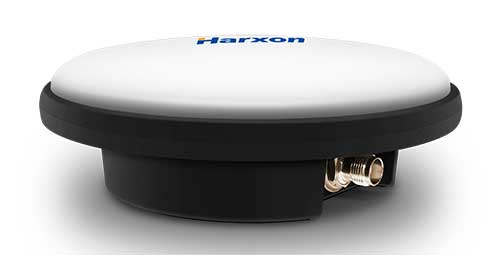
Harxon has launched a ruggedized GNSS antenna for applications subject to high shock and vibration environments such as i-construction machining applications. Integrated with reliable signal tracking and strong anti-interference performance, the IP69K ruggedized HX-CVX600A antenna provides end users with millimeter accuracy, durability and productivity, the company said.
I-construction promotes the use of automated machines on construction sites to improve productivity and provide support to workers.
The Harxon HX-CVX600A offers full support for reliable and consistent satellite signals tracking, including GPS, GLONASS, Galileo and Beidou, QZSS, IRNSS and SBAS, as well as L-band correction services.
By exhibiting a very stable phase center that adopts multipoint feeding technology, exceptional low elevation satellite tracking with symmetric radiation patterns, high gain with ultra-low signal loss, as well as outstanding wide-angle circular polarization (WACP), the Harxon HX-CVX600A performs with remarkable positioning accuracy and provides end users with full control of the job site, performing tasks more productively, meeting tighter positioning specifications, and avoiding rework caused by inaccurate positioning.
The HX-CVX600A GNSS antenna of Harxon also provides superior anti-interference performance. Its advanced low noise amplifier (LNA) excels in improved signal filtering and out-of-band rejection and restrains electromagnetic interference. It also provides strong multipath reduction capacity over all GNSS frequency bands for consistent and reliable GNSS signals, even under complicated environments such as congested urban areas or communication base stations.
The Harxon HX-CVX600A compact and low-profile antenna is Harxon’s first antenna with exceptionally firmness for hash operation environment as construction industry. The upper cover of the antenna is made of material with excellent chemical and high heat resistance. Its aerodynamic enclosure withstands exposure against dust, rain, splash or sunlight. Screws and pole mounts are both available, offering flexible installation.
The Harxon HX-CVX600A ruggedized antenna is now open for pre-sale; contact [email protected].
 a Hub is being used by more than 1,500 jurisdictions across the country as a part of their public safety GIS data management processes. The GeoComm Data Hub allows users to measure progress toward development and maintaining public safety grade GIS.