The U.S. Department of Homeland Security (DHS) Science and Technology Directorate (S&T) is hosting the 2020 GPS Equipment Testing for Critical Infrastructure (GET-CI) event. This event will take place during the summer of 2020.
The revised the due date for responses is May 8, 2020. Visit this site for more information.
S&T’s GET-CI events are a series of annual evaluation events intended for manufacturers of commercial GPS equipment used in critical infrastructure as well as critical infrastructure owners and operators.
DHS S&T recognizes the importance of accurate and precise position, navigation and timing (PNT) information to critical infrastructure and has a dedicated multi-year program to address GPS vulnerabilities in critical infrastructure, with a multi-pronged approach of conducting vulnerability and impact assessments, developing mitigations, exploring complementary timing technologies, and engaging with industry through outreach events and meetings.
Through these sustained efforts, the goal of the program is to increase the resiliency of critical infrastructure to GPS vulnerabilities in the near-term future.
Examples of measures that can be taken to enhance resiliency can be found in a DHS issued set of best practices released via ICS-CERT, titled “Improving the Operation and Development of Global Positioning System (GPS) Equipment Used by Critical Infrastructure.”
With the first GPS Block III satellite SVN 74 being set as healthy and active in January, GPS has reached another important milestone. Setting the vehicle healthy and active makes the satellite available for use by military and civilian GPS users around the world. GPS has been a hugely successful system, consistently exceeding its performance specification and providing users with levels of accuracy and availability that would have seemed astonishing only a few short years ago.
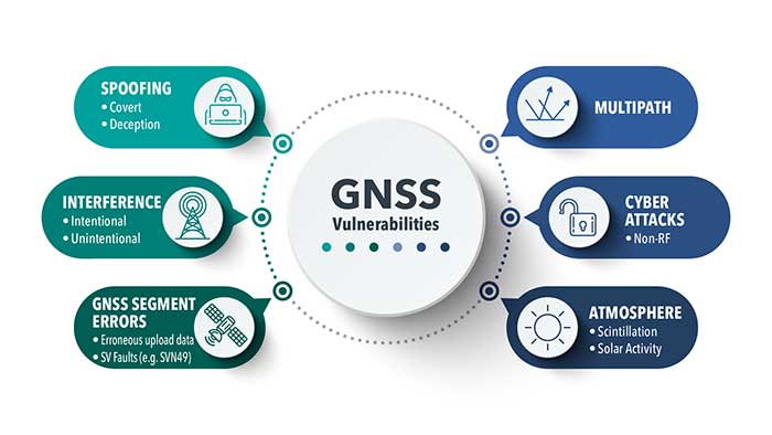
Despite these successes, the limitations of GPS and other GNSS have been highlighted by a catalog of real-world well-documented jamming and spoofing incidents, some of which have had serious impacts. With this increase of incidents, the military and commercial worlds have become increasingly aware of the vulnerabilities of sole reliance on GNSS. Interference with GNSS is a critical risk to not only business continuity, but to the safety of the world.
Image: Spirent Federal
Simply trusting the output from a GNSS receiver without question is no longer acceptable in safety- or liability-critical applications. The focus of many manufacturers and developers has been on assuring the integrity of reported GNSS PNT data.
Recently, more systems have begun using non-GNSS data sources to augment the GNSS solution. A GNSS receiver becomes one of the many sensors used in a system that combines their inputs to provide an assured, trustworthy source of precise positioning and timing data even when GNSS is disrupted. There are also active global initiatives in both commercial and military domains worldwide to seek and develop direct replacements for GNSS-based navigation and timing systems.These systems eliminate the use of GNSS completely and are termed “alternative navigation systems.”
Whether assured, augmented or alternative, these PNT systems need careful assessment. Their performance, robustness and resilience need to be measured in normal conditions and with interference.
Spirent is actively working to develop new, relevant test frameworks and designing the next generation of PNT test equipment that can easily integrate with and assess more than one technology. From inertial integrated with GPS to a number of alternative PNT systems that are being analyzed by the U.S. government, Spirent is working to unlock the maximum benefits of the next generation of PNT solutions.
Roger Hart, director of engineering, joined Spirent Federal in 2015. He has worked in development of spacecraft navigation systems, including GPS, for civil, NASA and defense applications since 1986. Guy Buesnel is Spirent’s specialist PNT Security Technologist covering the areas of PNT threats and mitigation.
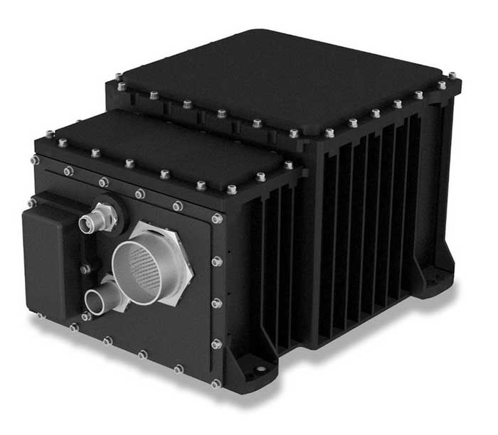
The SeaFIND inertial navigation system (INS) on April 1 received Type Approval from the U.S. Coast Guard, confirming that it meets an important international performance benchmark.
SeaFIND — Sea Fiber Optic Inertial Navigation with Data Distribution — was developed by Northrop Grumman for small- to medium-size combatant and auxiliary ships. With its small footprint, it can also be used on unmanned underwater and surface vehicles, or coastal and offshore patrol vessels.
SeaFIND builds from the software, algorithms and digital messages used on the MK39, a ring-laser INS installed around the world with the U.S. Navy and partner fleets. Instead of a ring-laser gyro, SeaFIND uses Northrop Grumman’s enhanced fiber-optic gyro technology (eFOG). eFOG maintains equivalent performance in a much smaller footprint — yet is more reliable.
“Fiber-optic technology is inherently more reliable with a higher mean time between failure rate than ring-laser gyro technology, which requires a high-voltage laser to operate and degrades over time,” explained Tom Disy, manager of Strategic Planning for Maritime/Land Systems & Sensors. An improved version of FOG, eFOG allows for the inertial measurement unit (IMU) within SeaFIND to achieve dependable navigation-grade performance, Disy explained.
SeaFIND’s embedded Navigation Data Distribution System (NAVDDS) software collects all the navigation data the ship receives, including SeaFIND and GPS data. NAVDSS then provides this data to other ship systems in a time-corrected, system-specific format. Time correction is necessary to maintain accuracy requirements, especially for applications requiring highly accurate dynamic attitude. NAVDDS’ low data latency allows the system to interface with any users that require accurate position and timing, such as combat systems or TACAN (tactical air navigation systems).
The SeaFIND INS complements the data received from GNSS. “Our inertial systems utilize GPS data when available; however, the SeaFIND INS also provides other key navigation data, including heading, roll and pitch,” Disy said. “The SeaFIND INS provides reliable position data for a significant period of time if the GNSS system data becomes unreliable or unavailable for any reason.”
SeaFIND is not subject to ITAR (International Traffic in Arms Regulations) and available for use by domestic and international navies.
UAV Navigation has developed a Visual Navigation System (VNS) that reduces the accumulated positional error during dead-reckoning navigation. The VNS leverages visual odometry techniques to determine the position and orientation of the aircraft by analyzing and processing the images captured by a camera installed on its underside.
Initial testing in real-time flight conditions has been a success, reports UAV Navigation. The system integrates well with the company’s flight-control solution to improve navigation in GNSS-denied environments.
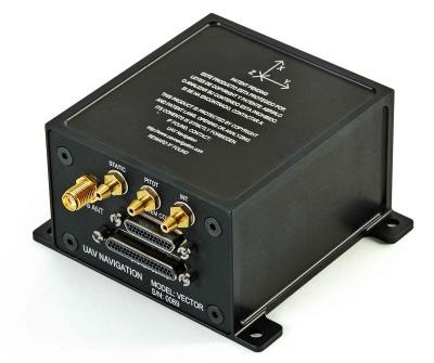
Vector autopilot. (Photo: UAV Navigation)
UAV Navigation’s sensors are tolerant toward GNSS failures (typically, in GNSS-denied scenarios) and can operate in dead-reckoning mode without compromising flight safety. However, a prolonged GNSS failure can lead to a significant navigation drift, and this is where the VNS comes in.
The VNS system includes a simple belly-mounted camera and image processing computer. Images from the camera are processed by a lightweight onboard computer, translating them into a relative change in the aircraft position. This information can be combined with the inertial sensors to reduce the overall drift to < 1% of the distance traveled, eliminating any drift associated with time.
Combined with the Vector autopilot, the VNS components provide a complete and robust autonomous flight control and navigation solution.
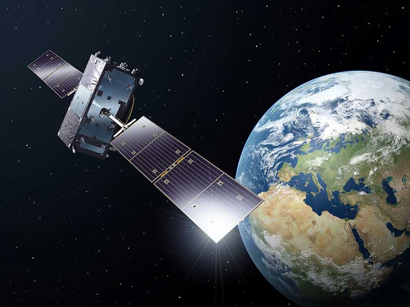
An artist’s rendering of a Galileo satellite in orbit (Image: ESA)
News from the European Space Agency
As European governments plan their phased recoveries from the lockdown states triggered by the COVID-19 pandemic, the positioning delivered through satellite navigation is becoming more important than ever before, said the European Space Agency (ESA). Location is a key requirement when attempting to monitor and map the spread of a disease and satnav is one of the main tools supporting this, the agency added.
Since the outbreak of the coronavirus, many applications have been developed that use satnav-based location data to monitor the global spread of the virus and map outbreaks.
For example, Romanian company RISE developed an app called CovTrack, which monitors people in a user’s vicinity made identifiable via Bluetooth connections to the user’s mobile phone and stores the identification data of these devices.
By pressing a button, users can access the database in which the unique identifiers of the mobile phones are registered (without having access to any personal data of these mobile phone users), to verify whether the persons with whom users came in contact have subsequently been confirmed with COVID-19, ESA said. If users have identified a potential contact, they can refer to the relevant authorities whether that contact requires inclusion among the monitored persons, or even testing for COVID-19.
According to ESA, CovTrack, developed on a pro-bono basis, is a spin-off from the existing AGORA project for festival management, supported through ESA’s Navigation Innovation and Support Programme, focused on future navigation technologies.
ESA, along with the European Global Navigation Satellite System Agency (GSA) and European Commission, put together a repository of these apps. The list, based on apps that are already working and available in app stores, includes practical apps that facilitate the daily lives of citizens. Check out the list here.
Europe’s Galileo, currently embedded in over 1.3 billion smartphones and devices worldwide, is helping to increase satnav accuracy and availability, especially in urban areas, ESA added.
In addition, GSA is developing its own Galileo-enabled application, Galileo for Green Lane, to monitor and ease the circulation of goods between European Union (EU) Member States while identifying potential congestion at Green Lane border crossings, thus ensuring EU citizens can access the needed supplies of critical goods.
America’s space assets are in danger from an array of kinetic, non-kinetic, electronic and cyber threats. These are wielded by nation states, primarily China, Russia, Iran and North Korea, though there are other countries as well as non-state actors.
On March 30, the Center for Strategic and International Studies (CSIS) Space Threat Assessment 2020 released a catalog that highlights the ways essential space-based services Americans rely upon can be degraded or eliminated. But it doesn’t do much to “assess threats.”
That said, it is still an impressive, useful and informative document. Some of what it doesn’t say can be inferred, and it provides a clear conclusion for policy makers and others.
Threat assessments are typically undertaken to:
Identify potential dangers,
Evaluate their credibility,
Weigh potential impact, and
Estimate the probability of the threat turning into an incident
This CSIS report generally stops after accomplishing the first two tasks.
Nonetheless, it is very instructive in a several ways.
Interference with Space Systems
First, it is packed with examples of how America’s adversaries have armed themselves, and stories about interference with space-based systems. Whether it is information about China training troops to use direct-ascent weapons, or reports about Russia’s mass GPS spoofing, the report’s matrix of threat categories is well supported by examples of real-world events.
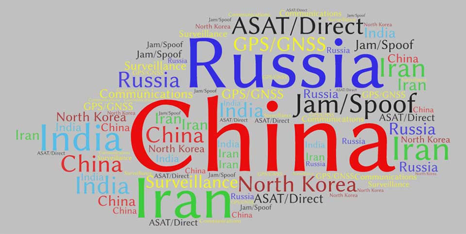
Second, while the report doesn’t overtly rank threats and adversaries, it is possible to infer some generalities by the attention the report devotes to each. Among potential adversaries, China was mentioned the most by far — 429 times. It was followed by Russia (275), Iran (206), India (141), and North Korea (132).
This word cloud from CSIS Space Threat Assessment 2020 shows that China received by far the most mentions, followed by Russia. (Image: RNT Foundation)
Jamming and spoofing
Jamming and spoofing seem to be the most credible threats and were mentioned 188 times, with ASAT and direct-ascent closely following with 179 mentions. This particular word count might not be reflective, though, as the report contains many more examples of real-world jamming and spoofing than ASAT and direct-ascent.
And of all the types of satellites that could be threatened, GPS/GNSS was the clear leader at 98 mentions, with communications and surveillance coming in at 42 and three, respectively.
In all fairness, at only 80 pages, it’s not possible for Space Threat Assessment 2020 to be an exhaustive analysis. And doing more would likely require making it classified. Then this exceptionally educational reference would not be nearly as available for the policy making audience that sorely needs it.
And it does provide an excellent bottom line for those making macro-level decisions about space policy and budgets going forward. From the report’s “What to Watch” section:
Electronic counterspace weapons continue to proliferate at a rapid pace in both how they are used and who is using them. Satellite jamming and spoofing devices are becoming part of the every-day arsenal for countries that want to operate in the gray zone — i.e., below the threshold of overt conflict. The jamming and spoofing of satellites has become somewhat common, and without strong repercussions these adverse activities could gradually become normalized…
One should expect that the rate of satellite jamming and spoofing incidents will only increase as these capabilities continue to proliferate and become more sophisticated in the coming years.
Drone maker Parrot is supporting French medical professionals facing the COVID-19 pandemic by helping Makers for Life design the MakAir respirator. This partnership comes as a part of their MakAir open source respirator project.
According to Parrot, it will be offering 500 engines for the launch of the MakAir project and will ultimately make 5,000 engines for the project. The engines will offer constant power, controlled vibrations, sufficient reliability and endurance to allow 24/7 operation for six weeks, Parrot added.
The MakAir project came to life when the COVID-19 pandemic highlighted a shortage of artificial respirators. Two other projects joined the cause to alleviate this issue. The first project, which brought together a number of manufacturers, was coordinated by Air Liquide and aims to increase the production of artificial respirators from 200 to 10,000 per year, starting in May 2020.
A second nonprofit project has spurred initiatives to create a simplified artificial respirator from standard components. Quentin Adam of the Makers For Life collective, in collaboration with Professors Antoine Roquilly and Pierre-Antoine Gourraud of the Faculty of Medicine of Nantes, and Erwan L’Her, head of the Intensive Medicine and Care Department of the Brest CHU, proposed a concept for a simplified artificial respirator.
The concept is based on using software to regulate inspiration-expiration, directly with the pneumatic system. The Nantes developer team turned to the CEA for industrialization of the concept, which had already been the subject of a proof of concept at the Brest University Hospital.
Parrot reaches milestone in U.S. Army Short-Range Reconnaissance drone program
Parrot has passed another milestone in the United States Army’s Short Range Reconnaissance drone program. As the final steps of this selection process, Parrot will participate in an operational assessment to support an Army production award decision. In anticipation of an increased demand signal from the Department of Defense, Parrot will start manufacturing prototypes of its dedicated drone in the United States, the company said.
“Parrot is honored to work with the DoD on this highly strategic project,” said Laurent Rouchon, vice president of security and defense at Parrot. “We have successfully met the high standards set over the last 12 months on the prototype efforts, and we look forward to entering this final phase and launching production in the USA.”
A roundup of recent products in the GNSS and inertial positioning industry from the May 2020 issue of GPS World magazine.
SURVEYING & MAPPING
RTK thermal mapper
Asphalt paving with RTK positioning
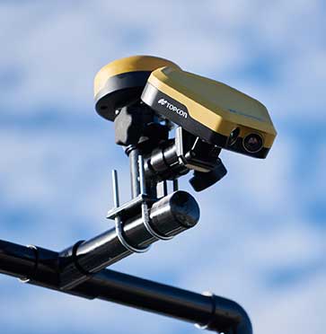
Photo: Topcon
The Thermal Mapper is designed to monitor temperature segregation to prevent future problems and measure performance, as well as provide accurate compliance reporting, using real-time kinematic (RTK) positioning accuracy. It records temperature readings behind an asphalt paver during paving and provides a visualization to operators in real time of whether the mix falls within a predefined temperature range. If the readings are unacceptable, operators can make adjustments. The system also creates data reporting files to download for applications such as U.S. Department of Energy compliance through the interactive Pavelink module, the Topcon cloud-based logistics application for asphalt paving.
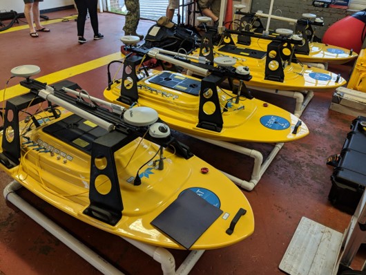
The Z-Boat 1800-T unmanned survey vessel is equipped with Trimble’s high-precision GNSS heading receiver and compatible with Trimble Marine Construction (TMC) software. The Z-Boat 1800-T enables marine construction and dredging projects to run efficiently and be monitored in real time anywhere in the world. The Z-Boat 1800-T is a high-resolution shallow-water hydrographic unmanned survey vehicle with the newly released Odom Hydrographic Echotrac E20 Singlebeam Echosounder and dual-antenna Trimble BX992 GNSS heading receiver. Each sensor is integrated into a compact, portable package for marine construction and allows data collection under harsh conditions. Both sensors can be removed and mounted on other watercraft and barges.
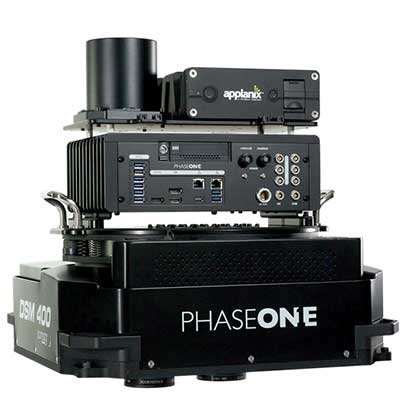
The 280MP Aerial Solution has an image coverage width of more than 20,000 pixels. The large format enables high-quality aerial surveys. Compact and lightweight, the aerial mapping solution consists of an iXM-RS 280F large-format camera, Applanix GNSS/inertial measurement unit (IMU) POS-AV receiver, DSM 400 Somag gyro-stabilized mount, Phase One iX Controller and iX Flight Management software. It is designed for use in a wide range of aircraft.
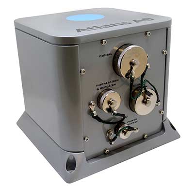
The Atlans Series of FOG-based inertial navigation systems (INS) is designed for land and air mobile-mapping applications. Based on iXBlue’s fiber-optic gyroscope (FOG) technology, the Atlans Series is a scalable range of north-seeking and north-keeping INS. They provide FOG performance to the full spectrum of land and air mobile-mapping applications and offer highly accurate positioning up to 0.01 meter in all conditions, including within GNSS-denied environments such as urban canyons, mountainous or forested areas.
The Maptitude 2020 U.S. Census Blocks Groups data is now available for the United States. The small-area Census Summary Level is packed with neighborhood information for making accurate geography-based decisions. Users can explore locations by income, income growth, daytime population, age, race, gender, ethnicity, occupation, housing characteristics and more. The data can be leveraged by data scientists and market research analysts using the Maptitude application. The files are also available as shapefile, KML, KMZ or GeoJSON.
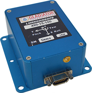
The high-performance LandMark 60 INS/GPS and compact LandMark 005 INS/GPS both feature advanced sensor-fusion technology, combining a 72-channel GNSS receiver with low-noise, high-output inertial sensors as well as barometric pressure and magnetometers. Both products use proprietary Velox processing technology and an extended Kalman filter (EKF), enabling precision position information during short-term GPS outages. The units provide accuracy of less than 2 nautical miles per hour during short-term GPS outages. The LandMark 60 provides +/– 0.3° heading accuracy and pitch/roll angle measurements of 0.1°. It is also available with an option for a real-time kinematic (RTK) GPS receiver. The LandMark 005 is less than 35 square centimeters, suitable for space-constrained applications that require a high standard of performance. Applications include flight control, navigation and stabilization for imaging, platforms and antennas. A development kit is available for set-up, configuration and data collection.
The IQCM-112 series of GNSS-disciplined oven-controlled crystal oscillators (OCXOs) incorporates an internal GNSS receiver with a 1-PPS output, which is compatible with an external GPS, GLONASS, BeiDou and Galileo source. It is housed in a 14-pin 60-millimeter-square package. When coupled to an external aerial antenna via the incorporated SMA connector, in the event of the loss of the GNSS signal the highly specified 10-MHz OCXO will switch in with a holdover capability of 1.5 µseconds for a 24-hour period, thereby maintaining lock until restoration of the reference signal. The standard operating temperature range of the module is –20° to 75° C, but it is also available with a –40° to 85° C operating temperature range. Other holdover specifications can be considered upon request.
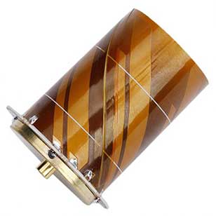
The HC977 covers GPS/QZSS-L1/L2/L5, GLONASS-G1/G3, Galileo-E1/E5a/E5b, BeiDou-B1/B2/B2a, IRNSS-L5 and L-Band correction services, as well as GLONASS-G2. Tallysman helical antennas are designed for high-accuracy applications where precision and light weight matter, such as unmanned aerial vehicles. The antennas are available in either a robust IP67 enclosure or an embedded format. The HC977 features a low current, low noise amplifier (LNA) that includes an integrated low-loss pre-filter to protect against harmonic interference from high amplitude interfering signals, such as 700-MHz band LTE and other near in-band cellular signals.
The RG500Q is a series of 5G sub-6-GHz modules optimized for internet of things (IoT) and machine-to-machine (M2M) applications. It supports the Qualcomm IZat location technology Gen9C Lite (GPS, GLONASS, BeiDou/Compass, Galileo and QZSS). The integrated GNSS receiver greatly simplifies product design and provides quick, accurate and dependable positioning capability. The RG500Q is provided in two variants: RG500Q-EA and RG500Q-NA. The RG500Q-EA 5G NR module has achieved commercial readiness and is now available to support global customers with mass deployment.
The V-150 is optimized for use from small naval vessels. It can be employed to support the homeland security, oil and gas and energy sectors. The UAV, which is free from International Traffic in Arms Regulations (ITAR) restrictions, incorporates two payload bays: up to 30 kilograms (kg) in the main bay and up to 12 kg in the nose. Within these, it provides a variety of payload options, including powerful electro optical and infrared (EO/IR) sensors, hyperspectral and multispectral cameras for airborne remote sensing, lidar and a variety of small tactical synthetic aperture radars (SAR) for delivering real-time intelligence in all weather conditions.
The SP-56 series is a family of small two-cylinder engines for UAVs. It can be integrated into small helicopters, which require smoother engine operation than single cylinders can provide. The SP-56 series provides 3.35 KW at 7,000 rpm; total weight of the carbureted version is 2.6 kilograms. The engine can be equipped with a generator or a starter generator on the rear output shaft. Hybrid applications are possible in which the engines are used only to generate electricity.
Two new small unmanned aerial systems (sUAS) are available to U.S. government defense and security markets. Vector and Scorpion form a 2-in-1 rucksack-portable system with an open source operating system, Auterion OS. The Scorpion tricopter can be used for dynamic urban environments and missions that require maneuverability and hover to collect intelligence, surveillance and reconnaissance (ISR) data. A tethering system enables 24/7 operations. By configuring the base fuselage with fixed wings and tail section, Scorpion transforms into Vector, a fixed-wing vertical takeoff and landing (VTOL) UAV for long-range, long-endurance ISR missions.
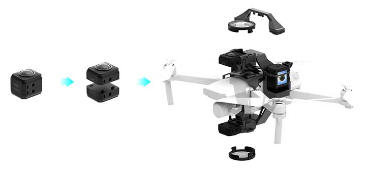
Insta360 ONE R is an interchangeable-lens action camera designed with three swappable Lens Mods for capturing different kinds of content. It has a Dual-Lens 360 Mod and a 1-Inch Wide Angle Mod co-engineered with Leica Camera AG. Advanced stabilization with Insta360’s FlowState algorithm achieves gimbal-like stabilization when shooting 360 degrees or with a standard wide angle lens. The 5.3K wide-angle lens can be swapped for a dual-lens setup that captures action in all directions at once. It captures brilliant 5.3K video and 19-megapixel photos even in complex lighting conditions. The ONE R is waterproof to 5 meters.
By Peter Steigenberger, Steffen Thoelert, Oliver Montenbruck and Richard B. Langley
The first GPS III satellite, “Vespucci,” was launched in December 2018, started signal transmission in January 2020, and was set healthy later that month. The second GPS III satellite, nicknamed “Magellan,” was launched on Aug. 22, 2019, on a Delta IV rocket from Cape Canaveral, Florida.
Magellan, also identified by its space vehicle number (SVN) 75 (here referred to as GPS-75), started signal transmission with standard pseudorandom noise code (PRN) number 18 (here referred to as G18) on March 13. The L1 C/A, L1 P(Y), and L2 P(Y) signals were activated at 17:16:30 GPS Time (GPST), while the L1C, L2C and L5 signals followed less than two hours after Vespucci’s launch at 18:59:30 GPST. Transmission of navigation messages started at 19:00:00 GPST with GPS-75 (G18) marked as unhealthy.
PRN G18 was previously used by the 27-year-old Block IIA satellite GPS-34 that had been already removed from the active GPS constellation on Oct. 7, 2019, but continued signal transmission until March 9, 2020. GPS-75 is already being tracked by a large number of tracking stations of the International GNSS Service (IGS). Based on the data collected by these stations, the Center for Orbit Determination in Europe (CODE), headquartered in Bern, Switzerland, has been providing precise orbit and clock products for this satellite since March 14.
A comparison we performed with the CODE precise orbit products revealed initial broadcast ephemeris errors of up to 100 meters (3D) and an orbit-related signal-in-space range error (SISRE) of about 13 meters. Within four days, a SISRE (orbit component) of 24 centimeters was achieved, which closely matches the performance of the rest of the GPS constellation.
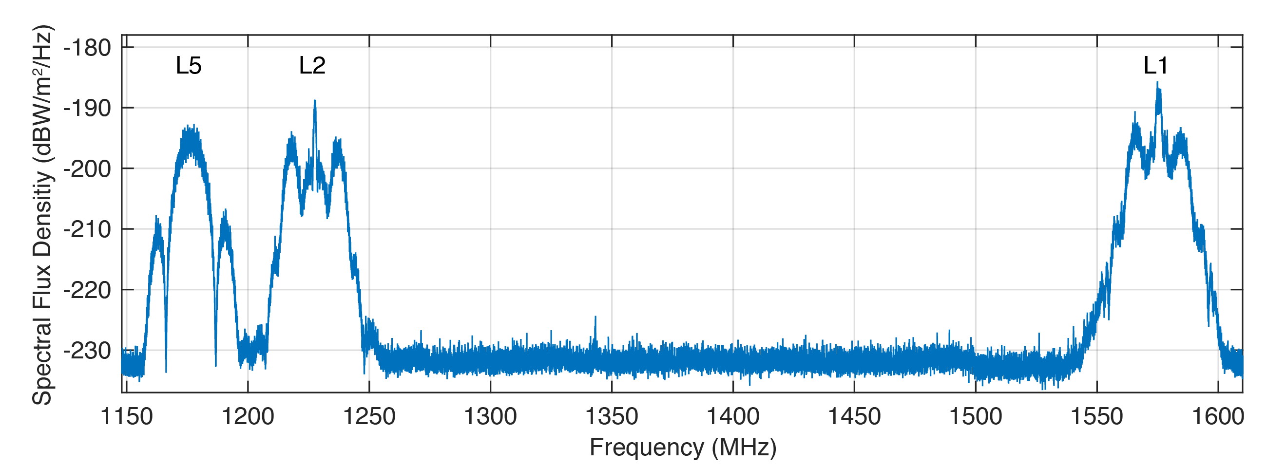
Figure 1 shows the spectral flux density of GPS-75 in the L1, L2 and L5 frequency bands obtained with the 30-meter high-gain antenna of the German Aerospace Center (DLR) located in Weilheim, Germany. The civil L1 C/A, L1C and L2C signals can be identified as sharp peaks in the center of the respective frequency bands.
FIGURE 1. Spectral flux density of GPS-75 measured with DLR’s 30-meter high-gain antenna. (Figure: Steigenberger, et al)
The prominent side lobes in the L1 and L2 bands are associated with the military M-code. The wide main lobe of the L5 signal with two smaller and sharper side lobes is caused by the superposition of two in-phase and quadrature signals with a 10-MHz binary phase-shift keying (BPSK) modulation. We found that all signals are in good shape and have a quality similar to that of the first GPS III satellite.
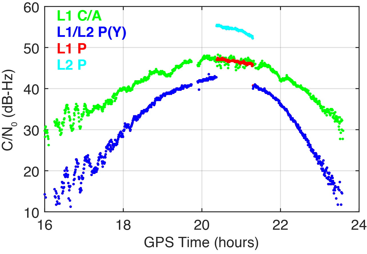
On March 16, 2020, we detected a significant change in the carrier-to-noise-density ratio of the L1 and L2 P(Y)-code signals. Figure 2 illustrates these changes for the IGS station located in Patumwan, Thailand (CUSV00THA). The L1 and L2 P-code signals are usually encrypted with the W-code to prevent spoofing (the generation of fake signals by adverse parties). The resulting encrypted signals are denoted by P(Y). Geodetic GNSS receivers are capable of tracking the P(Y) signals with a semi-codeless approach.
FIGURE 2. Carrier-to-noise-density ratio (C/N0) of the second GPS III satellite, GPS-75, tracked by the IGS station CUSV00THA in Patumwan, Thailand, on March 16, 2020. Between 20:22 and 21:18 GPST, unencrypted P-code signals were tracked. (Figure: Steigenberger, et al)
As a result, C/N0 of L1 P(Y) and L2 P(Y) are virtually identical and significantly smaller than the C/N0 of the unencrypted signals due to losses of the semi-codeless tracking technique. This can be seen in the blue-colored plot of Figure 2, where the C/N0 values of L1 P(Y) and L2 P(Y) are identical and smaller by 4.5–16 dB compared to L1 C/A depending on the elevation angle of the satellite.
However, between 20:22 and 21:18 GPST, an increase of the P-code C/N0 values was observed. The values changed by 4.5 and 12.5 dB for L1 and L2, respectively. This change is an indicator that unencrypted P-code signals were transmitted, rather than encrypted ones. This assumption can be verified by the “Anti-Spoof Flag” given as the 19th bit of the handover word (HOW) of the GPS LNAV navigation message.
Indeed, decoding of the raw navigation data from the IGS station CHOF00JPN in Chofu, Japan, showed that the Anti-Spoof Flag indicated a deactivation of anti-spoofing between 20:22:00 and 21:17:48 GPST and verified our assumption that unencrypted P-code signals were transmitted during that time period.
It has to be noted that only Javad receivers within the global multi-GNSS network of the IGS show this increase in C/N0. Other receiver types report continuous C/N0 values for the P-code signals, indicating that a semi-codeless tracking technique was continuously applied irrespective of the Anti-Spoof Flag.
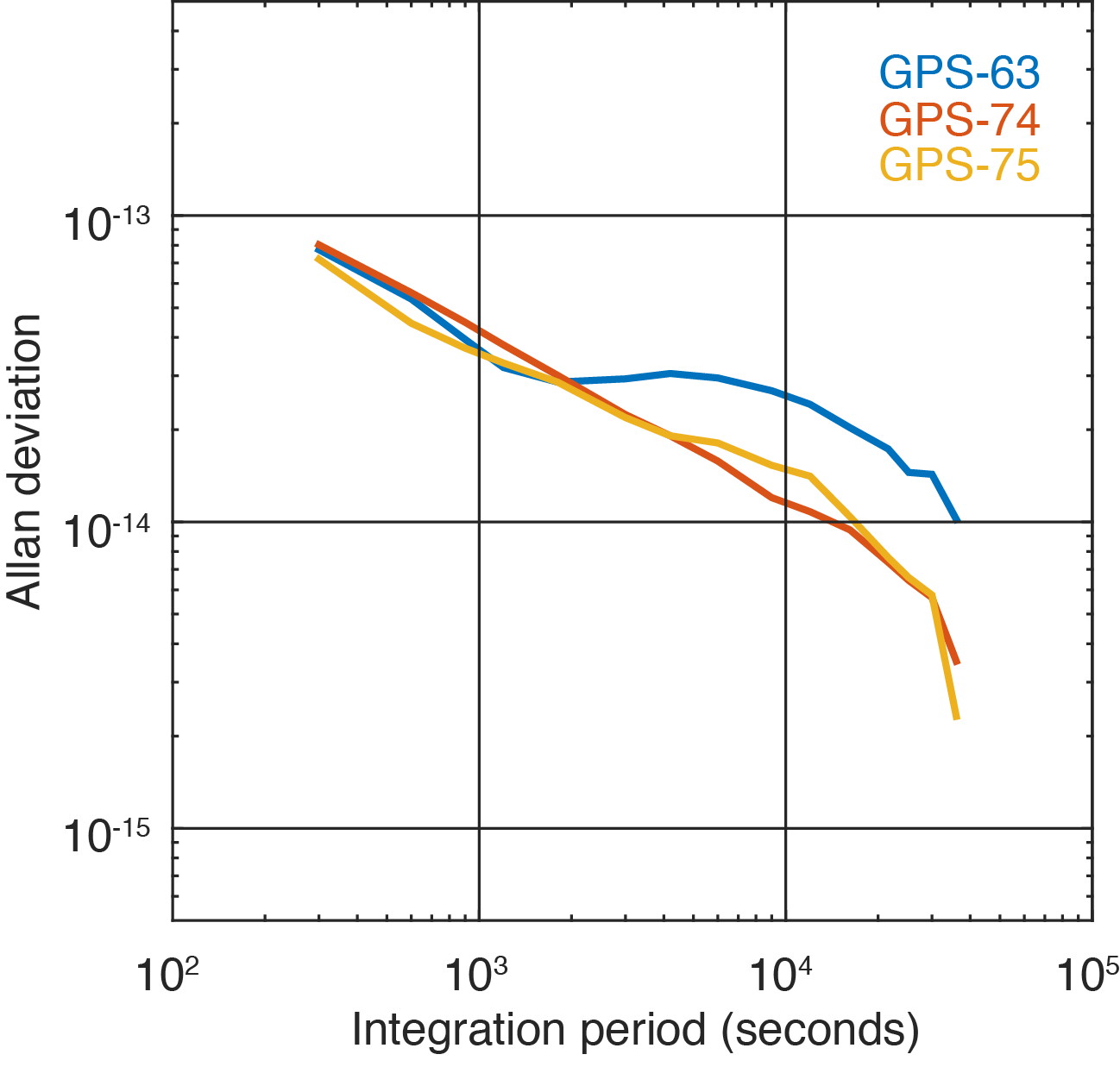
Figure 3 shows the two GPS III satellites’ Allan deviation, which measures the clock stability achieved in orbit; that is, the average frequency error over different time scales. In addition, the Block IIF satellite GPS-63 is shown, which is in the same orbital plane as GPS-75.
FIGURE 3. Allan deviation of the Block IIF satellite GPS-63 and the GPS III satellites GPS-74 and GPS-75 computed from 5-minute clock solutions produced by DLR. (Figure: Steigenberger, et al)
For integration times up to 2,000 seconds, the clock stability of GPS-75 is slightly better compared to the first GPS III satellite, GPS-74, but the situation is opposite for integration times larger than 5,000 seconds. The latter finding might be caused by the fact that GPS-75, unhealthy at the time, was tracked by a smaller number of stations compared to the healthy GPS-74.
As a consequence, the observed Allan deviation may partly be contaminated by orbit determination errors. In any case, both GPS III satellites clearly outperform the Block IIF satellite GPS-63 that suffers from thermal line bias variations visible as an increased Allan deviation starting at an integration time of about 2,000 seconds.
The activation of the second GPS III satellite transmitting the new civil L1C signal enables the estimation of differential code biases (DCBs) between, for example, the L1 C/A signal (Receiver Independent Exchange [RINEX] format observation code C1C) and different tracking modes of the L1C signal. Septentrio receivers track only the pilot component of the L1C signal (C1L), whereas Javad and Trimble receivers perform a combined data+pilot tracking (C1X).
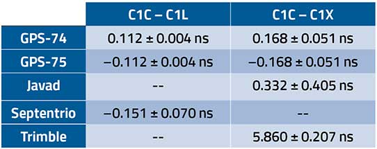
DCBs are estimated from pseudorange (code) observations of a global tracking network and are corrected for ionospheric delays obtained from global ionosphere maps. The DCB estimates shown in Table 1 are based on eight days of data from 10 Javad, 21 Septentrio and 3 Trimble receivers.
TABLE 1. Differential code bias estimates in nanoseconds between L1 C/A and L1C for the GPS III satellites and average receiver DCBs. (Data: Steigenberger, et al)
As we have applied a zero-sum condition for the estimation of satellite DCBs of just two satellites, the values of GPS-74 and GPS-75 obtained from the same type of L1C observables differ only by the sign. The DCBs estimated from different L1C observables, namely C1L and C1X, differ by 56 picoseconds, corresponding to a range difference of 1.7 centimeters. The receiver DCBs are quite homogeneous for receivers from each manufacturer but differ by up to 6 nanoseconds between various manufacturers.
On April 1, 2020, GPS-75 was set healthy and joined the constellation of operational GPS satellites. The third GPS III satellite, named “Columbus,” was shipped to the Cape Canaveral launch site in February 2020. Its launch is expected no earlier than June 30, 2020, and at least two GPS III launches per year are planned for the near future.
Equipment. Measurements reported in this article were collected with JAVAD GNSS TRE_G3TH and TRE_3, Septentrio PolaRx5 and Trimble Alloy multi-GNSS, multi-frequency receivers. The spectral overview was captured with a Rohde & Schwarz EM100 digital compact receiver.
PETER STEIGENBERGER and OLIVER MONTENBRUCK are scientists at the German Space Operations Center of the German Aerospace Center (DLR). STEFFEN THOELERT is an electrical engineer at DLR’s Institute of Communications and Navigation. RICHARD B. LANGLEY is a professor at the University of New Brunswick and editor of the “Innovation” column for GPS World magazine.
Further Reading
“Optimum Semicodeless Carrier-Phase Tracking of L2” by K.T. Woo in Navigation, Vol. 47, No. 2, 2000, pp. 82-99, doi: 10.1002/j.2161-4296.2000.tb00204.x.
Interface Specification IS-GPS-200K: NAVSTAR GPS Space Segment/User Segment Interfaces by Global Positioning Systems Directorate Systems Engineering & Integration, Los Angeles Air Force Base, El Segundo, California, March 4, 2019. Available online: https://www.gps.gov/technical/icwg/IS-GPS-200K.pdf
“Apparent Clock Variations of the Block IIF-1 (SVN62) GPS Satellite“ by O. Montenbruck, U. Hugentobler, E. Dach, P. Steigenberger and A. Hauschild in GPS Solutions, Vol. 16, No.3, 2012, pp. 303-313, doi: 10.1007/s10291-011-0232-x.
“Differential Code Bias Estimation Using Multi-GNSS Observations and Global Ionosphere Maps” by O. Montenbruck, A. Hauschild and P. Steigenberger in Navigation, 2014, Vol. 61, No. 3, 2014, pp. 191-201, doi: 10.1002/navi.64
SUGUS — a European Commission project to promote European GNSS services for the integration of drones into the airspace — is conducting an online survey of stakeholders.
SUGUS, the European Commission’s project for the development of European GNSS (Galileo and EGNOS) services for U-space, is carrying out a survey to identify, gather and understand stakeholders’ needs, and to improve user experience of E-GNSS in complex operations and built-up areas.
U-space is a set of new services and specific procedures designed to support safe, efficient and secure access to European airspace for large numbers of drones.
SUGUS members invite all the stakeholders to take part in the survey, including suppliers of U-space services, manufacturers of unmanned aerial systems (UAS) platforms and GNSS receivers, UAS pilots and operators, public bodies, authorities and organizations, and centers for UAS testing and training.
The survey will be available until May 15.
The survey results will be used as a valuable input to tailor the E-GNSS Service Provision layer to specific drone missions’ needs, allowing a better mitigation of risks in complex operations like BVLOS (beyond visual line of sight) and UAM (urban air mobility), increasing safety and security.
Also, the points of view collected will help to define the requirements and then the implementation of a new E-GNSS-based API which will deliver live and forecast information about performance, coverage, alerts to users and more.
The API will be called upon by UTM service providers, UAS designers or UAS systems developers, and integrated in existing commercial solutions.
“The survey organized by SUGUS is a key element for E-GNSS Programs to capture user requirements of the drone community,” explained Miguel Aguilera, European Commission advisor. “The results will be used to enhance EGNOS and Galileo Service Provision targeting drone operations, increasing safety and security, and facilitating a swift and efficient deployment of U-space.”
SUGUS Project
SUGUS (Solution for E-GNSS U-Space Service) is a European Commission’s project to promote European GNSS services (EGNOS and Galileo) for the drone market and for the effective and safe integration of these aerial platforms in the airspace.
It is a European Union H2020 R&D project to be carried out by GMV (main contractor) with everis Aerospace, Defense and Security as co-leaders of a consortium also involving VVA Brussels, ESSP, FADA-CATEC and Unifly.
SUGUS will help to develop services geared towards the effective integration of drones into the airspace. A series of trials will be held to show the benefits of E-GNSS for drone operators, as well as its approval by aviation authorities.
New sensor provides easy-to-integrate, cost-effective, triple-redundant IMU hardware and software for guidance and navigation solutions in autonomous machines and vehicles
Photo: Aceinna
Aceinna has launched a new high-accuracy inertial measurement unit (IMU), the IMU383ZA. The sensor integrates triple-redundant, 3-axis micro-electromechanical system (MEMS) accelerometer and gyroscope sensors.
The IMU383ZA is an improved, pin-compatible version of Aceinna’s IMU381ZA. It offers high performance (1.3 deg/hr, 0.08 deg/root-hr) and a triple-redundant sensor architecture for ultra-high reliability.
The miniature module is factory-calibrated over the -40° C to +85° C industrial temperature range to provide consistent performance through extreme operating environments for a wide variety of applications.
Applications include automotive advanced driver-assistance systems (ADAS), autonomous systems, drones, robotics, agricultural, construction and other industrial machines.
The IMU383ZA provides a standard SPI bus for cost-effective board-to-board communications. Other features include advanced synchronization and a bootloader for field upgradeability.
Measuring 24 x 37 x 9.5 millimeters, the IMU383ZA integrates a triple-redundant architecture that — combined with the small, low-cost packaging — meet the challenging performance, reliability and cost requirements of the automotive market including the areas of autonomous vehicles, self-driving taxis/delivery vehicles, ADAS systems, electronic stability control and lane-keep assist applications.
The triple-redundant sensor architecture consists of three independent, 3-axis accelerometer and 3-axis gyros for excellent accuracy and reliability. By embedding a triple-redundant sensor array, the IMU383ZA uses Aceinna’s proprietary voting scheme to utilize only valid sensor data. Any defective sensor output or errant dataset will be ignored or de-rated in importance.
Railway solutions power asset management and infrastructure maintenance
Estonian Railways Ltd., a state-owned company responsible for Estonia’s railway administration, has selected Hexagon’s Geospatial division to implement a transportation system that will automate and digitize the railway’s infrastructure maintenance, construction and traffic management processes.
The combined asset management system and geographic information system (GIS) platform will help the company’s 700-plus employees efficiently manage assets and workflows.
Powered by Hexagon’s GeoTrAMS, a web-based system for tram and light-rail infrastructure, and GeoMedia, a flexible GIS management platform, Estonia Railway will be able to visualize assets on a map while integrating with other companies and external systems.
Hexagon’s state-of-the-art registry will serve multiple information systems and users at the same time, centralizing the use of asset and spatial data while avoiding data duplication and ensuring that users have access to the most up-to-date information.
“As a company, we are in a unique situation of simultaneously implementing Hexagon-specific spatial data modules for rail infrastructure management and Microsoft’s ERP for asset management, gathering and digitizing different fragmented data, unifying different workflows and applying new data management principles,” said Maia Sokk, innovation manager at Estonian Railways. “Based on our strategic goals for the next four years, we are significantly modernizing our traffic management systems. Implementing Hexagon’s technologies is an important link in this ambitious plan.”
Prior to selecting Hexagon, Estonian Railways used a fragmented system of disparate software applications to manage assets and infrastructure across its 750 miles of railroad, 129 platforms and 60 stations. With the new solution in place, Estonia Railway will be able to improve operational efficiency and transparency, better control expenses connected to the infrastructure and streamline administrative tasks.
“Estonian Railways is forward-thinking in its use of location intelligence for managing infrastructure and operations,” said Mladen Stojic, president of Hexagon’s Geospatial division. “We are excited to deliver an integrated solution that will help the railway effectively monitor and maintain its assets while also ensuring successful management of rail traffic, construction projects and services.”
Estonian Railways has been responsible for ensuring the smooth operation, management and maintenance of the country’s railway infrastructure since 1870.
Learn more about how Hexagon helps organizations close the gap between the geospatial and operational worlds with its transportation solutions.
 The U.S. Department of Homeland Security (DHS) Science and Technology Directorate (S&T) is hosting the 2020 GPS Equipment Testing for Critical Infrastructure (GET-CI) event. This event will take place during the summer of 2020.