Blog

  • FAA Summary Grants Speed UAS Exemptions

    The “summary grant” process the Federal Aviation Administration (FAA) used last week to issue 30 Section 333 unmanned aircraft systems (UAS) exemptions is an example of how the agency is using a flexible regulatory approach to accommodate this rapidly evolving technology, according to a news statement from the FAA.

    The new approach will speed up Section 333 exemption approvals for many commercial UAS operators, the FAA said. Section 333 is the part of the 2012 FAA reauthorization law that lets the Secretary of Transportation determine if certain low-risk UAS operations can be authorized before finalizing the small UAS proposed rule published in February.

    Although the FAA still reviews each Section 333 petition individually, the agency can issue a summary grant when it finds it has already granted a previous exemption similar to the new request. Summary grants are far more efficient because the FAA doesn’t need to repeat the analysis performed for the original exemption on which they are based. Summary grants are a tool the FAA can use in all exemption areas, not just UAS. 

    The FAA’s experience in reviewing the Section 333 petitions shows they generally fall into two categories: film/television production and aerial data collection. Most exemptions in these categories will likely be handled through the summary grant process. For unique requests, the agency will still publish the petition in the Federal Register for public comment and will conduct a detailed analysis.

    The FAA also made two other changes to the Section 333 exemption process last week:

    • The agency now allows operations under these exemptions by people who hold a recreational or sport pilot certificate. Previously, Section 333 operators were required to have at least a private pilot certificate. The newly added certificates are easier to obtain, and therefore less costly, than a private pilot certificate.
    • A third-class medical certificate is no longer required. Now, a Section 333 operator only needs a valid driver’s license to satisfy the medical requirement. This change is consistent with the agency’s approach for sport pilot certificate holders, who may fly light sport aircraft with a driver’s license and no FAA medical certificate.  

    For more information on the FAA and UAS, go to http://www.faa.gov/uas

    Brian Wynne, president and CEO of the Association for Unmanned Vehicle Systems International (AUVSI), applauded the change. “For months, AUVSI has advocated for a more streamlined process for Section 333 exemptions that will help more industries realize the benefits of UAS technology,” Wynne said. ” The FAA’s new summary grant process is a step in the right direction that cuts through the red tape while making it easier for operators to fly UAS. We applaud the agency for lifting unnecessary restrictions and enabling more commercial uses of the technology in a safe and responsible manner.”

  • DJI Unveils Phantom 3 UAV with Indoor Positioning

    DJI Unveils Phantom 3 UAV with Indoor Positioning

    The Phantom 3 in flight at a press event.
    The Phantom 3 in flight at a press event.

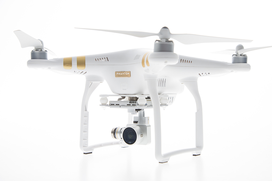
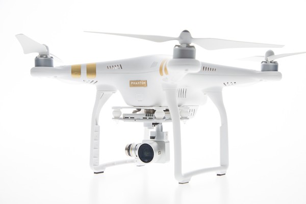
    DJI has launched a new drone in its Phantom series. The Phantom 3 comes in two variations, Professional and Advanced, both of which provide greater control and creative options than the popular Phantom 2. On April 8, DJI held three simultaneous events in London, Munich, and New York to mark the release of the Phantom 3.

    Both Phantom 3 versions feature the strongest professional control features DJI has developed so far. Using DJI’s Visual Positioning system, the Phantom 3 can hold its positioning indoors without GPS and can easily take off and land with the push of a button. With Vision Positioning technology, visual and ultrasonic sensors scan the ground beneath the Phantom 3 for patterns, enabling it to identify its position and move accurately.

    DJI’s Lightbridge technology is also integrated, enabling control at up to 1.2 miles (2 km) away and a live HD video stream from the camera with almost no latency.

    “In developing the next generation Phantom, DJI remained committed to providing a top-tier flight experience in one easy-to-use platform,” said DJI CEO Frank Wang. “We pride ourselves in creating a flying camera that fits in a backpack and can be ready to take professional quality videos from the sky in less than a minute.”

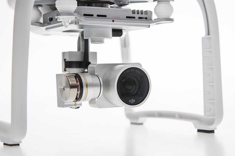
    The Phantom 3 Professional is capable of shooting 4K video at up to 30 frames per second, while the Phantom 3 Advanced records at resolutions up to 1080p at 60 frames per second. These cameras are stabilized using 3-axis gimbals to keep the video smooth regardless of flight or wind conditions.

    Both models shoot 12-megapixel photos using a 94-degree FOV, distortion-free lens, and a high-quality, 1/2.3-inch sensor that is more sensitive to light than the sensor in previous Phantom 2 Vision models.

    All camera settings — including ISO, shutter speed and exposure compensation — can be set using both the DJI Pilot app and the physical controls on the remote controllers. The DJI Pilot app also features a Phantom 3 flight simulator for virtually practicing aerial maneuvers, and a Director feature, which automatically edits the best shots from flights into short videos that can be shared immediately after landing. The upgraded app also allows pilots to livestream their flights to YouTube.

    “Pilots, whether they are journalists, extreme athletes, or global travelers — will not just be able to share aerial videos of where they were, but will also be able to send a YouTube link to their friends and colleagues to show them the aerial perspectives of where they are right now,” said DJI’s San Francisco General Manager Eric Cheng. “This has tremendous potential for changing the way we share experiences with one another.”

    The Phantom 3 by DJI
    The Phantom 3 by DJI

    Photo: The Phantom 3

  • DJI Unveils Phantom 3 UAV with Improved Imagery

    The Phantom 3 in flight at a press event.
    The Phantom 3 in flight at a press event.

    DJI has launched a new drone in its Phantom series. The Phantom 3 comes in two variations, Professional and Advanced, both of which provide greater control and creative options than the popular Phantom 2. On April 8, DJI held three simultaneous events in London, Munich, and New York to mark the release of the Phantom 3.

    Both Phantom 3 versions feature the strongest professional control features DJI has developed so far. Using DJI’s Visual Positioning system, the Phantom 3 can hold its positioning indoors without GPS and can easily take off and land with the push of a button. With Vision Positioning technology, visual and ultrasonic sensors scan the ground beneath the Phantom 3 for patterns, enabling it to identify its position and move accurately.

    DJI’s Lightbridge technology is also integrated, enabling control at up to 1.2 miles (2 km) away and a live HD video stream from the camera with almost no latency.

    “In developing the next generation Phantom, DJI remained committed to providing a top-tier flight experience in one easy-to-use platform,” said DJI CEO Frank Wang. “We pride ourselves in creating a flying camera that fits in a backpack and can be ready to take professional quality videos from the sky in less than a minute.”

    The Phantom 3 Professional is capable of shooting 4K video at up to 30 frames per second, while the Phantom 3 Advanced records at resolutions up to 1080p at 60 frames per second. These cameras are stabilized using 3-axis gimbals to keep the video smooth regardless of flight or wind conditions.

    Both models shoot 12-megapixel photos using a 94-degree FOV, distortion-free lens, and a high-quality, 1/2.3-inch sensor that is more sensitive to light than the sensor in previous Phantom 2 Vision models.

    All camera settings — including ISO, shutter speed and exposure compensation — can be set using both the DJI Pilot app and the physical controls on the remote controllers. The DJI Pilot app also features a Phantom 3 flight simulator for virtually practicing aerial maneuvers, and a Director feature, which automatically edits the best shots from flights into short videos that can be shared immediately after landing. The upgraded app also allows pilots to livestream their flights to YouTube.

    “Pilots, whether they are journalists, extreme athletes, or global travelers — will not just be able to share aerial videos of where they were, but will also be able to send a YouTube link to their friends and colleagues to show them the aerial perspectives of where they are right now,” said DJI’s San Francisco General Manager Eric Cheng. “This has tremendous potential for changing the way we share experiences with one another.”

    Phantom-3

    Phantom-3

  • Esri Offers Webinar on ArcGis for Utility Assets

    Esri offers a standard set of templates that include maps, apps, and tools that support water, electric, gas and telecommunication industry workflows. To learn how to use these templates, tune in to the Esri live training seminar Utility Asset Inspection Using ArcGIS on April 16 at 9 a.m./11 a.m. and 3 p.m. PDT.

    Users will learn how to configure the templates based on their own content, and then deploy them to support common inspection workflows.

    After viewing the seminar, users will understand how to

    • Organize your content for field inspections.
    • Collect inspection information while in the field.
    • Summarize inspection results for reporting.

    GIS managers and analysts who use ArcGIS software and need to learn how to prepare, collect, and summarize inspection information will find this seminar useful.

    Participants will need a broadband Internet connection and an Esri account to watch the live training seminar. Esri accounts can be created at esri.com/ltsclick Login at the top right, and register name and e-mail address.


  • ComNav, CGEOS Build First BeiDou CORS Station in Europe

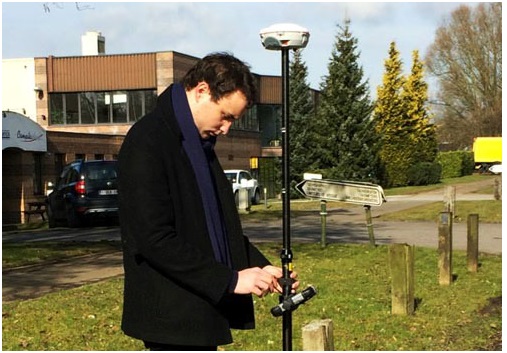
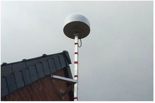
    Experiencing the Qiao Station with ComNav T300 for surveying.
    Experiencing the Qiao Station with ComNav T300 for surveying.

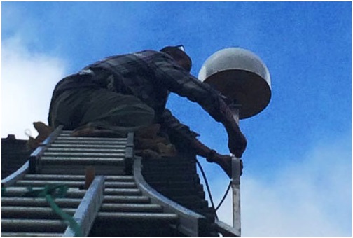
    Europe’s first commercial BeiDou CORS station  — Qiao CORS Station — has been built in Wallonia, Belgium. ComNav partnered with local company CGEOS – Creative Geosensing on the project. ComNav develops and manufactures GNSS OEM boards and receivers for demanding high-precision positioning applications.

    Qiao means bridge in Chinese, and Joël van Cranenbroeck, managing director of CGEOS, is working to build the bridge between the Chinese and European GNSS industries by introducing the Chinese high-precision GNSS technologies of ComNav Technology to European users, ComNav said in a statement.

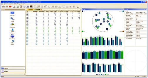
    The Qiao Station can track BeiDou Navigation Satellite System on the three frequencies and transmit observation data in RTCM format in real time through NTRIP and observation data in RINEX format. It enhances the positioning performance and result by combining BeiDou with GPS and GLONASS.

    Currently, the BeiDou Navigation Satellite System mainly covers  the Asia Pacific region. Though China is still in the process of building it into a global network, up to six BeiDou satellites can now be tracked in Europe during certain periods of the day. With the new Qiao Station, European users can now try the BeiDou system.

  • Galileo NAGU Announces Completion of Ground Upgrade

    News courtesy of CANSPACE Listserv.

    The European GNSS Service Centre has issued Notice Advisories to Galileo Users announcing the completion of a ground segment upgrade and system testing as of 1 April 2015. The three fully operational Galileo satellites (GSAT0101, GSAT0102, and GSAT0103) have been declared available from 1 April 2015 at 00:00 UTC.

    • GSAT0101 (ID:11) payload on PHM clock
    • GSAT0102 (ID:12) payload on RAFS clock
    • GSAT0103 (ID:19) payload on PHM clock
    • GSAT0104 (ID:20) is still considered unavailable as it only transmits an E1 signal.
    • GSAT0201 (ID:18) and GSAT0202 (ID:14), although now in improved orbits, have not been declared available.

    Meanwhile, the two recently launched satellites (GSAT0203 and GSAT0204) are slowly drifting to their assigned orbits. They are not yet transmitting standard L-band signals.

    Read more about the upgrade here.

  • Galileo Ground Segment Back Online

    Galileo Ground Segment Back Online

    Galileo's worldwide ground segment as of March 2013.
    Galileo’s worldwide ground segment as of March 2013.

    News from the European Space Agency

    The worldwide Ground Mission Segment providing all Galileo navigation messages has completed a full-scale hardware and software migration to version V2.0, and is now fully operational again.

    The Ground Mission Segment was turned off Jan. 26, allowing the migration to take place over the month of February. The following month was taken up with detailed checking by operations and system, concluding in a final “check point” on March 31 to validate the successful migration.

    “The upgrade of the Galileo Ground Mission Segment from V1.2 to V2.0 has provided better overall performance and availability, along with improved robustness, security and operability,” explained Martin Hollreiser, overseeing mission segment development for ESA, with Thales Alenia Space France as prime contractor. “The overall outcome of our check point confirmed that the new GMS V2.0 migrated to the operational chain is a major improvement and no blocking issues were identified. An overall 25 percent performance improvement is confirmed.”

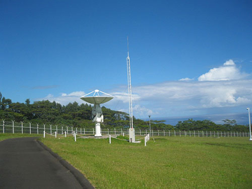
    The new Papette Uplink Station in Tahiti, French Polynesia, used for uplinking navigation messages for rebroadcast to users from Galileo satellites.
    The new Papette Uplink Station in Tahiti, French Polynesia, used for uplinking navigation messages for rebroadcast to users from Galileo satellites.

    “The process began with the upgrade of the infrastructure hardware at Galileo’s control centre in Fucino, Italy, and remote sites disconnected from the system to be monitored locally,” Hollreiser said. “This physical process was followed by a software update, and then a full-scale test campaign before handing back to operations and resuming the nominal Galileo mission on 6 March. 

    “Three new sensor stations (Kiruna, Ascension and Azores) — used to monitor the satellite navigation signals — were also added to the operations chain, as well as a new uplink station (Papeete) — used to uplink corrections incorporated in the navigation message to the satellites for broadcast to the users.”

    Papette Uplink Station

    Galileo is Europe’s satellite navigation system. The accuracy of its positioning fixes ultimately comes down to accurate satellite orbit determination and timing measurements and corrections that are precise down to a few billionths of a second. A satnav receiver determines its position by calculating the time it takes for signals to arrive from multiple satellites in space.

    To keep those timings sufficiently precise, the entire Galileo system can be thought of as one gigantic planetary-scale clock, with the Ground Mission Segment at its core, determining the exact satellite orbits and synchronizing all the satellite and terrestrial elements of that clock: the relevant control center is linked to a global network of ground stations (sensor and uplink stations).

    Operated by Telespazio, Fucino in central Italy is among the world's largest satellite ground stations.
    Operated by Telespazio, Fucino in central Italy is among the world’s largest satellite ground stations.

    Each of the Galileo satellites in space carries multiple atomic clocks on board, which, although very accurate, drift slightly over time. So sensor stations on the ground extract measurements from the satellites’ signals and send these to the Galileo control center in Fucino, Italy. Here, processing takes place to derive very accurate satellite orbits and clock synchronization.

    Any necessary corrections are then built into an updated navigation message that is then transmitted to the satellites via a set of five uplink stations. The satellites themselves then rebroadcast these corrections down to the users, to be automatically interpreted by receivers to maintain service precision.

    Worldwide Galileo Ground Segment

    During the upgrade, this regular updating of navigation messages no longer took place, so the accuracy of the Galileo signals to users slowly degraded. Users were informed of this process through a flag in the signal itself, as well as through the online Notice Advisory to Galileo Users (NAGU) notification process.

    An updated NAGU has been issued to inform users that Galileo services are back. Right now the signals are being used for technical testing, with early services for the public projected for 2016.

    “A further Galileo Ground Mission Segment update is foreseen for the end of this year,” Martin said. “But this time the upgrade should be executed in a seamless manner, with no interruption of services.”

  • TU-Automotive Announces Connected Car Award Finalists

    TU-Automotive has announced finalists in several categories for its 2015 awards. Finalists in the Best Connected Car System Integrator category include chipmakers Qualcomm and u-blox, among others. Nominees in other categories include TomTom, NXP SemiconductorsTelogis and Geotab.

    The finalists represent excellence, innovation and leadership in the connected car industry, TU-Automotive said.

    More than 400 entries were submitted. The winners will be revealed at the TU-Automotive Awards Ceremony on June 2 in Detroit. Here is the full list of finalists:

    Car Maker of the Year 2015

    • Audi
    • BMW of North America, LLC
    • Ford Motor Company
    • Qoros auto
    • Toyota Motor Sales
    • Volvo Car Group

    Commercial Vehicle Maker of the Year

    • Mack Trucks
    • Scania CV AB
    • Volvo AB

    Telematics Service Provider of the Year

    • Airbiquity
    • Ericsson
    • General Motors
    • Jasper
    • Nuance Communications, Inc.
    • Total Traffic and Weather Network
    • Xtime

    Commercial Telematics Service Provider of the Year

    • Inthinc Technology Solutions Inc.
    • Openmatics
    • Teletrac Inc
    • Telogis

    Best Connected Car System Integrator

    • Atos
    • AutonomouStuff LLC
    • HERE, a Nokia company
    • Car Connectivity Consortium
    • Covisint
    • Dash Labs
    • Elektrobit (EB) Automotive
    • Luxoft
    • Movimento
    • Parkopedia
    • Qualcomm Technologies, Inc.
    • Symphony Teleca Corp.
    • u-blox AG
    • Uievolution, Inc.

    Best Commercial Vehicle System Integrator

    • Eyeris
    • Geotab
    • KPIT Technologies Ltd.
    • Navistar
    • Spireon, Inc.
    • Symphony Teleca Corp.
    • TomTom Telematics

    Best Insurance Telematics Product

    • Allstate Insurance Company
    • AXA & MyDrive Solution
    • Codan Insurance (RSA) & The Floow
    • Direct Auto Insurance & DriveFactor
    • Industrielle Alliance, Assurance auto et habitation inc. & Baseline Telematics
    • Progressive Insurance & zubie inc
    • RightTrack® by Liberty Mutual & Octo Telematics North America
    • Suncorp Group & Wunelli, a LexisNexis Company

    Best Telematics Product or Launch in an Emerging Market

    • CarIQ Technologies Private Limited.
    • Discovery Insure
    • iTrans Technologies Pvt Ltd
    • Omnicomm
    • Qoros Auto
    • TATA Motors Ltd, India
    • TechMahindra
    • TOWER Insurance (in partnership w/ DriveFactor Inc.)

    Best Safety or ADAS Solution

    • Argus Cyber Security
    • BrightWay Vision
    • Delphi Automotive PLC
    • Elektrobit (EB) Automotive
    • Eyeris
    • General Motors
    • NXP Semiconductors
    • TomTom
    • Valeo Wiper Systems

    Best Mobility Solution Industry Newcomer

    • Carma
    • County of Santa Clara Roads & Airports Department
    • Dash Labs
    • Hyundai Blue Link Smartwatch app
    • Local Motion
    • moovel GmbH
    • parku – The Parking App
    • QNX Software Systems

    Industry Newcomer

    • ATG Risk Solutions
    • CarKnow LLC
    • CloudCar
    • Dealer-FX
    • Eyeris
    • gestigon
    • MobiWize
    • Nebula Systems Ltd
    • Rivet Radio, Inc.
    • TowerSec

    TU-Automotive Influencer of the Year

    • Andrew Poliak, Global Director Business Development – Automotive, QNX Software Systems
    • Dominikus Hierl, Chief Executive Officer, Telit Automotive Solutions
    • Erica Klampfl, PhD, Future Mobility Manager, Ford Research & Advanced Engineering
    • Jeff Owens, Chief Technology Officer & Executive Vice President, Delphi
    • Matt Jones, Senior Technical Specialist – Infotainment, Jaguar Land Rover
    • Paul Drysch, Global Director – Connected Car, Jasper
    • Paul Stacy, Founding Director of Wunelli, a LexisNexis Company
    • Ricky Hudi, Head of Electrics/Electronics, Audi AG
  • TeeJet Offers GNSS Guidance System for Precision Ag

    Teejet-Matrix430The TeeJet Matrix 430 is a low-cost GNSS guidance system featuring a graphical, touchscreen user interface that allows for fast setup and intuitive operation. The system is designed for a wide range of field applications including spraying, spreading, tillage and solid seeding.

    The Matrix 430 features a 4.3-inch/110-mm high-contrast, full-color display for excellent visibility, even in bright light conditions, TeeJet said. It contains an integral GNSS receiver that supports both GPS and GLONASS signals with a choice of two available antennas for enhanced performance in a wide range of geographies.

    Other features include: return-to-point, coverage mapping, field area measurement, applied area alert, elapsed time counter, simple job reporting, and a choice of four guidance modes: Straight AB, Curved AB, Center Pivot, and Last Pass.

    Teejet-Matrix430-2“The Matrix 430 builds upon our highly successful and proven CenterLine 220 guidance product while providing an enhanced user interface and expanded capabilities,” said Tim Stuenkel, global marketing manager with TeeJet Technologies. “This product is designed for the grower who wants a simple, affordable guidance system — whether they are a first time buyer or experienced user of GNSS guidance products.”

    TeeJet Technologies manufactures a comprehensive line of products including agricultural spray nozzles for various pesticide/fertilizer applications, boom components, valves/manifolds, strainers, and spray guns, as well as GPS guidance systems, sprayer control systems, ISOBUS job computers, assisted steering systems and other precision farming products. In addition, TeeJet Technologies continues to invest in research and development to advance precision application and control technology.

  • ION GNSS+ 2015 Technical Program Available Online

    The ION GNSS+ 2015 technical program is now available online, and registration is open.  ION GNSS+ 2015 will be held Sept. 14-18 (tutorials Sept. 14-15) at the Tampa Convention Center, Tampa, Fla.

    This year, unlike in previous years, the technical program (registration brochure) will only be distributed online. Users can search and sort the program online or download and print a PDF version. A printed on-site guide book will still be available to attendees.

    ION GNSS+ 2015 is the 28th International Technical Meeting of the ION Satellite Division and the world’s largest technical meeting and showcase of GNSS technology, products and services and other sensors in today’s marketplace.

    Attendees who book a hotel room first will save $200 by entering the hotel confirmation number from the Tampa Marriott Waterside Hotel and Marina at the start of the registration process. Attendees will need a valid hotel confirmation number to claim this discount during registration.

    ION GNSS+ brings together international leaders in GNSS and related positioning, navigation and timing fields to present new research, introduce new technologies, update current policy, demonstrate products and exchange ideas. The focus of this meeting is the growing emphasis on GNSS and the rapidly evolving field of alternative navigation methods.

    This year’s conference will feature panels of industry experts, policy updates, the world’s largest GNSS commercial exhibit and more than 300 technical presentations presented through:

    Peer-Reviewed Tracks

    • Multisensor Navigation and Applications
    • Algorithms and Methods
    • Advanced GNSS Technologies

    Systems and Application Tracks

    • Mass-Market Applications
    • High Performance & Safety-Critical Applications
    • System Updates, Plans and Policies

    GPS World Editor and Publisher Alan Cameron discusses the importance of the annual ION GNSS Conference at the 2014 event, also held in Tampa.

  • Hexagon Geosystems Releases More Airborne Imagery

    Hexagon-imagery

    The Hexagon Imagery Program, or HxIP, has released captured airborne imagery for approximately 25 percent of the U.S. with various regions of Canada and Europe. As more content partners join the HxIP in 2015, program coverage is rapidly increasing with full coverage of the coterminous U.S. expected by the end of the year.

    Launched in June 2014, the HxIP streams valuable geospatial content and delivers professional-grade airborne images captured with Leica Geosystems’ airborne sensors, including enhanced-resolution, four-band orthos, streamable and rasterised point clouds, and stereo imagery, through two service categories:

    • Basemap offers cached background maps of current 30 centimeter orthorectified imagery that will be updated on a regular basis.
    • Multispectral Imagery supports image analysis and exploration activities with 30-centimeter, four-band orthorectified imagery and related digital surface models (DSM).

    Imagery for a full 11 states plus portions of six other states in the U.S. have been provided in the HxIP as part of its airborne imagery offerings from the 2014 flying season. Portions of Canada and Europe are also available in the recent release.

    “We’re pleased to have met our 2014 program goal, providing access to quality and consistent airborne imagery for thousands of clients around the globe,” said John Welter, president of Leica Geosystems Geospatial Solutions Division and director of the HxIP. “We are well on our way of realizing our 2015 goals with collection currently underway in Europe and North America.” 

    The HxIP airborne imagery content is available through the cloud via multiple content service providers:

    Through a distribution partnership with Esri in February, the 2014 collection is now available to even more users on Esri’s ArcGIS Marketplace.   

    “Serving HxIP via Esri’s ArcGIS Marketplace gives geospatial professionals another choice in accessing the most current and accurate geospatial imagery available,” said Juergen Dold, president of Hexagon Geosystems. “The focus of our new partnership is to provide imagery in a simple and efficient way across a wide array of professional consumers.”

    This vision was reinforced by Esri Director of Imagery Lawrie Jordan. “Leica Geosystems is recognized globally as providing the highest quality and most accurate airborne imagery available, and Esri is delighted to offer this content to GIS professionals through our ArcGIS Marketplace,” Jordan said.

  • Septentrio Introduces Next-Generation GNSS Receiver, AsteRX4

    Septentrio Introduces Next-Generation GNSS Receiver, AsteRX4

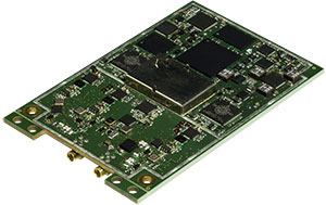
    Septentrio's AsteRx4 OEM.
    Septentrio’s AsteRx4 OEM.

    Septentrio has launched its next-generation dual-antenna GNSS receiver, the AsteRx 4 OEM. The AsteRx 4 OEM is a multi-frequency, dual antenna receiver that incorporates the latest innovative GNSS tracking and positioning algorithms from Septentrio. It offers users in the marine, machine control and agricultural industries precision, accuracy, reliability and ease of use, the company said.

    Thanks to Septentrio’s positioning engine, which uses advanced multipath and ionosphere modeling algorithms, the AsteRx4 offers robust positioning scalable from meter to centimeter accuracy. Together with precise heading and reliable error estimates, the AsteRx 4 OEM functions in tough conditions on land, at sea or in the air.  

    Use of all available constellations (GPS, GLONASS, BeiDou, Galileo) provide the operator with a reliable solution even in obstructed areas such as in narrow city streets or at the corners of large structures, Septentrio said. The AsteRx4 OEM features the full range of positioning techniques from stand-alone to real-time kinematic (RTK).

    For users who operate in more remote regions of the globe, the AsteRx4 OEM supports Veripos and Terrastar correction PPP services. Furthermore, the receiver features special interference mitigation technology which filters out ambient intentional and unintentional RF interference.

    The AsteRx4 OEM is straightforward to set up and integrate with existing systems, Septentrio said. It has the similar hardware interface as earlier AsteRx receivers, and supports the same open and well documented command and binary output format. Users will be able to operate their receiver without special configuration software by using the very accessible web interface, which is available via network and USB connections.

    “AsteRx4 incorporates many powerful improvements based on practical difficulties our customers face in the field every day,” said Jan Van Hees, vice president of Business Development, Septentrio. “We are particularly proud of the solutions for interference robustness that we have incorporated into our new ASIC,  the GReCo4; the solid and reliable positioning algorithms that result from taking the receivers into the most extreme environments and from focusing not only on accuracy, but on reliability of the position solution.”

    The AsteRx4, along with all the AsteRx family of receivers, will be on display at booth W40 for the duration of Ocean Business 2015 starting April 14 at the National Oceanography Centre, Southampton, UK.