From Hong Kong to Berlin, from Sydney to New York, the operations of hospitals, airlines, banks, and scores of other businesses and services were disrupted on July 19 due to a glitch in a software update issued by the cybersecurity firm CrowdStrike that affected computers using the Microsoft Windows operating system.
TheNew York Times described it as “a stunning example of the global economy’s fragile dependence on certain software, and the cascading effect it can have when things go wrong.”
Regular readers of this magazine, and of this column in particular, will know where I am going with this: like Windows, GPS — and, more broadly, GNSS — presents a single point of failure for many systems. That is, if GPS fails, it will stop those entire systems from working.
Possible challenges and threats to GPS use include space weather; interference/jamming and/or spoofing of receivers; error or failure of satellites, monitoring, or control; and, in the most extreme case, an attack on satellites, monitoring, or control.
The National Space-Based PNT Advisory Board continues to focus its efforts on its excellent PTA strategy: to protect (“prevent or remove conditions that degrade, distort, or deny GPS use”), toughen (“make GPS use more robust against challenges and threats”), and augment (“provision of GPS enhancements as well as provision and use of alternate [PNT] sources that complement, back up, or replace (partly or entirely) use of GPS”) civil uses of GPS. More on that soon.
Meanwhile, others are urging we think of GNSS as only one of several complementary means to achieve the mission of positioning, navigation and timing (PNT) with accuracy, availability, integrity, continuity and coverage. For that perspective, see Mitch Narins’ piece. He writes that we should focus “on services that are not space-based, operate in different areas of the spectrum, are capable of higher power, and can be installed and evolved more quickly to mitigate emerging threats.”
The European Space Agency’s recent PNT Vision 2035 paper, written by a panel of independent external PNT experts to advise next year’s ESA Ministerial Conference, summarizes European discussions on PNT in the past several years. In the words of Luis Mayo, the chair of the advisory committee that wrote the report, “there is more to PNT than satellite navigation.” While we must “sustain the existing satellite-based navigation systems,” he argues, we should also promote “the development of alternative independent PNT systems.” Read a short interview with Mayo by Dana Goward, starting on page 19.
Yet other efforts integrate GNSS with different, independent techniques to create new synergies. One example is ESA’s Genesis multi-modal space mission, which aims to improve geodetic applications by collocating on board a single well-calibrated satellite the four space-based geodetic techniques: GNSS, very long baseline interferometry (VLBI), satellite laser ranging (SLR) and Doppler Orbitography and Radio-positioning Integrated by Satellite (DORIS).
“This first-time collocation in space will establish precise and stable ties among these key techniques,” write the authors of this quarter’s “Innovation” column.
If not GNSS, then what? That is an interesting question.
To some, it means GNSS is so important and unique that without it, all is lost. They enthusiastically support only GNSS-centric research and development, believing that any issues that GNSS has today — such as lack of resilience — can be resolved given enough time and money. It includes pushing for the discontinuance of ground-based systems and the “re-purposing” of their resources to produce more satellites and more space-based signals. It demonstrates an admirable and true dedication to the belief that GNSS is the mission.
To others, these words have a different and darker meaning, warning of a clear and present danger. To them, it means “When (not if) GNSS is not available, what other source(s) of positioning, navigation and timing services (PNT) will be available to support GNSS users’ missions and goals?” For these purpose-driven individuals, GNSS is a means — not the mission, which is to provide the necessary positioning, navigation and/or timing performance, such as accuracy, availability, integrity, continuity and coverage, required to ensure the nation’s safety, security and economic well-being.
Unfortunately, some who have made GNSS their mission strive to convince others that it should be their mission, too!
GNSS is magic — but only when it works. It has played and will continue to play a crucial part in advancing our knowledge and abilities and supporting diverse use cases worldwide. It should and must be supported, but not to the exclusion of everything else. Recently, the magic has failed numerous times all around the world and, as a PNT community of suppliers and users, we must know we are capable of so much more.
We also know that the vast majority of civil PNT service needs are local, not global — based in part on the population density of users and their use cases. Over the years, GNSS’ accuracy and coverage have spoiled us. We even chose to see GNSS interference events as proverbial “black swans.” At the same time, the abandoning of well-engineered, resilient local solutions in favor of a global, one-size-fits-all mentality has been appealing to many. We know this approach is fraught with danger. Throwing away perfectly acceptable, resilient local means rather than enhancing them and bringing their technology into the 21st century may, as a PNT community, be our biggest regret. In many ways we have already gone too far.
I encourage our PNT community to commit to doing more, to open up our minds to design, develop, evolve, create, install, implement and operate more resilient PNT sources and more resilient user systems for which PNT services are critical inputs — especially by focusing on services that are not space-based, operate in different areas of the spectrum, are capable of higher power, and can be installed and evolved more quickly to mitigate emerging new threats. Most importantly, we all need to accept and support the true mission of our PNT community, the “why” that drives our innovative solutions: to ensure PNT services always will be available to support our safety, security and economic well-being.
Is it possible that we have already oversold the potential — or at least the timing — for when we expect operational electrical vertical take-off and landing (eVTOL) air taxis? United, Delta, Southwest, and other airlines seem intent on being part of the coming air taxi game, but locking up future potential without anything delivered could be risky.
Now, this eVTOL stuff is not cheap, and it does not come quickly—it takes a massive amount of investment and effort to create a new mode of air transport, especially if it could be wholly or even partially autonomous. Most eVTOL outfits have decided to launch initially with a piloted option, leaving autonomy for later.
The initial stages of the development process involve reviewing the designs, followed by vetting and selecting subcontractors. A strategic plan is then established to develop a few operational prototypes. Alongside this, a firm strategy must be created to ensure compliance with agency regulations, resulting in the demonstration of proof of concept.
The process could be accelerated with a piloted airframe derived from a proven baseline, but eVTOLs are a new concept. Although partially derived from UAVs, eVTOLs differ significantly from existing aircraft. UAVs are not big enough to carry passengers and have not received approval to transport people. True, the automation angle has taken significant steps forward in recent years, but certifying that these systems will always operate correctly, without minimal chance of failure while flying over city centers and over many, many people – well, that’s another coat of many colors! Let’s just say these are BIG STEPS to initiate a new form of air transportation.
Nevertheless, despite the excitement and seemingly optimistic timelines for achieving FAA or other regulatory approval for fully operational eVTOL aircraft capable of safely transporting passengers, most major airlines have already committed to significant purchases and investments in this technology.
United Airlines conditionally committed to buy 200 Archer Aviation Midnight eVTOL aircraft for $1 billion in early 2021, added an option of $500 million for another 100, and recently took more partial ownership when Archer pursued a public listing through a merger with Special Acquisition Company (SPAC) Atlas Crest Investment Corp.
Archer has been moving its aspirations in several other directions while it works closely with the FAA to achieve certification of the Midnight eVTOL. Notably, the company has been granted a Part 135 Air Carrier and Operation certification by the FAA, which allows Archer to operate a for-profit airline with not only the Midnight eVTOL but also existing commercial aircraft, presumably including helicopters. Using other aircraft in the interim could allow Archer to prove out routes before having operational eVTOLs available and generate revenue. United and Archer have already selected at least one initial route in Chicago, from the city center to O’Hare airport.
Archer has also been busy signing up partners in Korea. Demonstrations are planned for Q4 2024 and in Abu Dhabi, Dubai, and other locations across the UAE. The forecasting service will start in late 2025.
Back in the U.S., Southwest Airlines — another Archer investor — is also working with the company on the West Coast to develop routes around population centers in California. Archer has signed up with a local developer to establish Vertiports, locations with suitable ground access for passengers, landing/take-off and rapid charging facilities for eVTOL aircraft and existing helicopters. Southwest plans to install these stationsat five locations: South San Francisco, Napa, San Jose, Oakland, and Livermore.
Another agreement with Signature Aviation is designed to provide Archer with access to general aviation terminals and electrical supply for eVTOL operations in New York, Los Angeles, San Francisco Bay Area, and Texas, including United Airline hubs at Newark International (EWR) and Chicago O’Hare (ORD) Airports, as soon as the end of 2025, almost the exact date that United expects to start eVTOL passenger ferry services to and from O’Hare.
Stellantis has also invested around $150 million in Archer, plus another $55 million in June 2024, as the two work on establishing a high-volume 350,000 sq ft eVTOL manufacturing facility in Georgia. A new agreement between the two companies brings additional investment, intended to take the facility to a yearly build output of 650 eVTOLs.
Photo: Joby Aviation
Unlike United, Delta Airlines and Joby Aviation aim for door-to-door service, intending to pick up passengers at their own homes and bring them directly to Delta at the airport. With fewer, larger propellers, Joby claims a top speed of 200 mph, compared to Midnight’s 150 mph. Apparently, both Midnight and the Joby eVTOL have a passenger capacity of one pilot plus four passengers.
Another significant June 2023 investment in Joby was reported to have come from SK Telecom (SKT) in Korea, which made an equity investment of $100 million in Joby. The Korean government is promoting aerial ride-sharing through a phased demonstration program, for which the partners signed up to participate in early 2022. Joby was also certified to be a Part 135 air carrier almost two years earlier than Archer.
Both Archer and Joby have already delivered eVTOL aircraft to the U.S. Air Force (USAF) for on-base evaluation. The USAF has been promoting eVTOL development for some time, not only for on-base logistics but also, apparently, evaluation for front-line resupply operations.
Eve eVTOL rolls out and is joining the flight test program. (Photo: Eve Air Mobility)
Eve Air Mobility has received significant investment from aircraft manufacturer Embraer in Brazil, and Toyota is supporting high-volume manufacturing. This year, contact was made with Air-X in Japan to buy ten aircraft with options for 40 more—just one customer of several who have placed Letters of Intent to buy over 3,000 Eve eVTOL aircraft. United Airlines is another one of those customers who also placed a conditional order for 200 Eve eVTOL and options for another 200 aircraft back in 2022.
This is a very short overview of just a few of over 200 potential eVTOL-piloted and autonomous UAV manufacturers that have turned into passenger-carrying air taxis. The partial investment story behind these companies and their air-mobility adventures indicates that even though it is going to be quite some time before these aircraft start to hop over cities to airports – making a potential two-hour journey in 10-15 minutes at the exact projected cost as existing ride-sharing, a lot is riding on a successful outcome. Maybe United’s duel track investment in both Archer and Joby will also ensure that one or the other will bear fruit. These few outfits we’ve reviewed have a long way to go, but their investing partners seem to have accepted the risk and have faith that their long-term roll of the dice will end up in their favor.
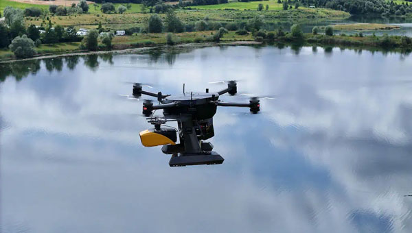
Xer Technologies and YellowScan have partnered to integrate the YellowScan Navigator bathymetric system into Xer Technologies’ UAVs. This collaboration aims to enhance UAVs’ capabilities for conducting long-range bathymetric surveys and underwater inspections, which are essential in various fields such as environmental monitoring, coastal management, and infrastructure development.
The integrated system allows users to collect high-resolution and accurate bathymetric data, even in challenging aquatic environments. YellowScan’s green laser lidar technology is a key component of this system, providing precise underwater mapping capabilities. Xer Technologies’ UAVs are designed for extended flight durations and can operate for more than two hours, facilitating coverage of larger survey areas in a single mission. This feature is particularly beneficial for projects that require extensive data collection over vast aquatic regions.
The YellowScan Navigator can achieve a precision of 3 cm and can operate at a maximum altitude of 100 m above ground level. The laser has a range of up to 120 m and features a scanner field-of-view of 44 °. It weighs 3.7 kg.
The top screen showing the hydrogen maser and cesium clocks in an adjacent isolated room used for realization of the timescale for research purposes. Students presenting their work to the USNO and Microchip Inc., visitors. (Photo: University of Alabama, Tuscaloosa)
The University of Alabama, with the support of the National Science Foundation (NSF), has established a program unlike any other in the country. It focuses on positioning, navigation, timing, and frequency (PNTF) as its own discipline, with a special emphasis on precise timing.
The Alabama Collaborative for Contemporary Education in Precision Timing (ACCEPT) is an NSF Research Traineeship (NRT) program designed to train the next generation of graduate (master’s and Ph.D.) degree holders in PNTF.
ACCEPT provides interdisciplinary training and education for physics, engineering, mathematics and computer science majors. The school hopes to make it a graduate program eventually. Enrollees are awarded a fellowship that includes a $34,000/yr stipend.
“The ACCEPT program was created because industry and government officials told us they could never find enough people in this field,” said Adam Hauser, the program’s executive director, who is also an associate professor of physics and astronomy at the university. According to Hauser “It is the only program in the nation directly addressing a larger scale workforce development in precision timing.”
Left to right: Dr. LeClair, Dr. Hauser and Dr. Bandi founded and run the ACCEPT PNT program at University of Alabama. (Photo: University of Alabama, Tuscaloosa)
ACCEPT’s Technical Director — also billed as “Time Lord” — is Thejesh Bandi, an associate professor. He reinforces Hauser’s message about the scarcity of focused talent in the area. “This field is greying,” he says. “We need young minds who will also bring in fresh ideas.”
Hauser describes the program as “a flexible multidisciplinary course curricula that includes professional development, and real-world training with our industry and government partners.”
The program’s “interdisciplinary” nature is reflected in the ACCEPT team. In addition to physics and astronomy, faculty from mathematics, electrical and computer, civil, aerospace, and mechanical engineering, as well as the communications and higher education departments, are included.
This diversity of expertise is needed for ACCEPT’s ‘holistic education” approach founded on four pillars.
Industry-Directed Curriculum: First, because the goal is to supply qualified graduates to fill critical national needs in industry, the foundational curriculum is based on and will continue to evolve with input from commercial entities in the PNTF space. In addition to several government agencies and labs, the ACCEPT Advisory Board includes representatives from SpectraDynamics, Aerospace Corporation, Raytheon Technologies, Microchip Technologies, L3Harris Technologies, OEWaves, Inc, Safran S.A., Northrop Grumman Corporation and the Resilient Navigation and Timing (RNT) Foundation.
Sustained Industry & Community Immersion: The program’s major focus is moving beyond academia. Internships and PNTF professional community events are mandatory. Students attend the National Institute of Standards and Technology (NIST) Time and Frequency Division’s time and frequency seminar each year. In their second year, they begin attending the Institute of Navigation’s annual Precise Time and Time Interval (PTTI) meeting. As their research and professional skills mature, they are expected to progress from attendees to poster presenters and speakers.
Professional Development: Reinforcing preparation for moving beyond the classroom, ACCEPT trains students to “… effectively work across academic, policy, governmental and industry sectors,” according to Hauser. “They need to be able to advocate as a professional to a larger audience effectively.” This means including students in programs like the university’s Speaking Studio and Capstone Center for Student Success. Communication skills, teamwork and ethics are particular focus areas.
Research: Bandi’s Research Quantime Lab is hosted by Professor Patrick LeClair’s Department of Physics and Astronomy. “Research projects for ACCEPT fellows and trainees are designed in conjunction with our government and industrial partners and focus on cutting-edge innovations that solve today’s problems in currently used technologies,” Le Clair said.
The lab strongly focuses on Quantum Engineering research, though there are also opportunities in Characterization and Calibration, Networking and Synchronization, and research into Precision Devices.
Click here for more information about applying for an ACCEPT fellowship or becoming an industry partner.
Skyfront has released the Skyfront MagniPhy, a UAV magnetometer designed for surveying, mineral prospecting, locating orphaned wellheads, and detecting landmines and unexploded ordnance (UXO). The MagniPhy aims to enhance data quality, efficiency, and safety in these applications.
The Skyfront MagniPhy features a new enclosure and universal attachment mechanism compatible with third-party magnetometer sensors and a variety of UAVs, including DJI, ArduPilot, and PX4-based models. Developed in collaboration with Geometrics, of the MagArrow II UAS-enabled magnetometer, the MagniPhy is available for existing MagArrow users and other UAV magnetometer operators through retrofit services or as a new kit for seamless integration.
The MagniPhy offers improved data quality and enhanced ability to detect subterranean objects, thanks to its rigid attachment, which maintains constant magnetometer heading during flight and minimizes magnetic noise. Its aerodynamic design reduces motion-induced noise and enhances performance in high winds. Additionally, the device is highly portable, folding from 16.4 ft to 1.4 ft to fit in carry-on luggage, and features swappable batteries providing up to eight hours of operation.
Skyfront’s high-endurance hybrid gas-electric multicopter UAVs complement the MagniPhy’s capabilities, enabling extensive magnetic surveys. These systems are deployed globally for various applications, including finding abandoned oil and gas wellheads in the U.S. and detecting landmines and UXO in Ukraine. The MagniPhy offers a safer and more efficient solution to traditional helicopter surveys and short-duration battery-powered UAVs.
FJDynamics has launched the FJD AT2 Max auto-steer system. The system builds on the original AT2, which is already used in more than 30 countries. The AT2 Max features enhanced hardware with a larger 12.1-inch display and a powerful CPU processor. According to FJDynamics, these upgrades offer users faster processing for smoother operation on the screen while accurately navigating various terrains.
In addition to the AT2 Max, the new FJD ATS Precision Spray Autosteering System is built on FJDynamics’ proven autosteering technology, the ATS brings precision to crop protection by enabling tractors to spray accurately while automatically steering along desired paths. These models have been field-tested and are designed to meet various agricultural needs.
The ping200XR TSO has received TSO-C112e and TSO-C166b for transponder and ADS-B functionality — TSO-C188b for its internal pressure altimeter, and TSO-C145e for the integral aviation GPS.
It is a compact Mode S ADS-B transponder with an integrated GPS receiver, measuring 47 x 72 x 10mm and weighing just 52 grams. This device combines the functionality of a transponder and GPS into a single unit, making it suitable for airspace access and operations involving certified aircraft.
The ping200XR facilitates seamless integration into national and international airspace systems by enabling aircraft detection by secondary surveillance radar (SSR), traffic collision avoidance systems (TCAS), and ADS-B IN receivers. Additionally, it has received technical standard order (TSO) certification from the FAA, ensuring that it meets specific performance standards established by the aviation regulatory body.
The ping200XR can be used in high-altitude aircraft and balloons operating in Class A airspace and above. With the new TSO certifications, the device can now be utilized in regions that mandate such approvals, including Europe, the United Kingdom, Australia and New Zealand. This certification also makes the ping200XR TSO a viable option for aircraft pursuing type certification, such as electric vertical take-off and landing (eVTOL) and Advanced Air Mobility (AAM) platforms. The certified version is scheduled to become available for purchase starting in September 2024.
SandboxAQ has been awarded an SBIR Phase 2B Tactical Funding Increase (TACFI) by the United States Air Force (USAF) to further develop its dual-use AQNav magnetic navigation (MagNav) system. Under the contract, SandboxAQ and its partner AFWERX will explore new configurations of the AQNav technology, including a pod-based attachment, for use on a broader range of aircraft platforms, such as unmanned aerial systems.
AQNav navigation technology combines proprietary artificial intelligence (AI) Large Quantitative Models (LQMs), powerful quantum sensors and the Earth’s crustal magnetic field, resulting in a solution that operates effectively in all weather conditions, day or night and across any terrain. AQNav technology is completely passive and operates in real-time, offering an unjammable and un-spoofable alternative to traditional navigation methods. This system functions entirely independently of GNSS, offering a secure and dependable navigation option in environments where satellite signals may be compromised or unavailable. This is a key example of applying quantitative AI – AI models trained on quantitative data and not language. SandboxAQ is a leader in Large Quantitative Models (LQMs), in this case to pull the signal from the background magnetic noise for navigation.
This funding increase extends a prior Direct-to-Phase-II SBIR contract awarded to SandboxAQ in January 2023. To date, SandboxAQ’s AQNav technology has logged more than 200 flight hours and more than 40 sorties across multiple regions on four different aircraft types, ranging in size from single-engine planes to large military transport aircraft. In this process, AQNav was successfully tested in two USAF exercises – Exercise Golden Phoenix and Exercise Mobility Guardian – Air Mobility Command’s largest exercise at the time.
AQNav uses a powerful quantum magnetometer system to acquire data from Earth’s crustal magnetic field, which exhibits geographically unique patterns – similar to a human fingerprint. AQNav uses proprietary LQMs to compare this data against known magnetic maps, enabling the system to quickly and accurately find its position. Due to the high sensitivity of foundational quantum sensors, AI algorithms are applied to improve the signal-to-noise ratio, removing any mechanical, electrical, or other interference that would impact the system’s ability to acquire its location.
AQNav is available worldwide and can be used in air, land, and sea applications. The system does not rely on visual ground features or satellite transmissions to function and is not affected by weather conditions. Additionally, AQNav’s passive technology emits no electronic signals, which reduces the aircraft’s detectability. It operates at room temperature, requires no shielding, and has a small form factor that can be integrated into a wide variety of platforms, from multi-engine airliners to unmanned aerial vehicles.
SandboxAQ is developing AQNav as a dual-use solution to address the need for resilience to GPS vulnerabilities, which extends societally and economically. In addition to the USAF, SandboxAQ is engaged with several aerospace leaders to test and develop AQNav, including other allied governments, Boeing and Acubed — Airbus’s Silicon Valley research and innovation center.
IN THE BEGINNING of the space age, there was only one space-based positioning technique: satellite Doppler. Shortly after the launch of the first satellite, Sputnik 1, on Oct. 4, 1957, it was realized that by using a receiver to measure the Doppler frequency shift of a satellite’s transmitted signals combined with knowledge of the satellite’s orbit, the position of the receiver could be determined.
The United States Navy used this concept to develop the Navy Navigation Satellite System, commonly known as Transit. Although its initial use was for positioning Polaris submarines, it was released for commercial use in July 1967. Transit was used worldwide for positioning and navigation until it was decommissioned at the end of 1996. We talked about Transit in the introduction to the article “Easy Peasy, Lemon Squeezy: Satellite Navigation Using Doppler and Partial Pseudorange Measurements” in this column’s October 2012 edition.
Next on the scene was very long baseline interferometry (VLBI). This was, and still is, a technique for high-resolution mapping of galactic and extragalactic radio sources such as quasars. It was invented by Canadian and American radio astronomers with the Canadians getting the first interference “fringes” on a transcontinental baseline on May 21, 1967. VLBI uses radio telescopes, separated by 100s or 1,000s of kilometers, to record signals on storage media (previously magnetic tape and subsequently disk-based systems) synchronized by atomic clocks, typically hydrogen masers. The recordings are played back and cross-correlated at a central facility to produce the observation data – essentially the difference in arrival times of the radio signals at the radio telescopes. It was apparent that VLBI measurements could also be used to precisely determine the vector baselines between pairs of radio telescopes eventually down to a few millimeters, so VLBI became an important geodetic technique, even measuring the drift of the continents in essentially real time. We featured an article on VLBI in this column in February 1996, “The Synergy of VLBI and GPS.”
Around the same time that VLBI was being developed, satellite laser ranging (SLR) made its debut. SLR works by precisely measuring the two-way travel time of laser pulses sent from telescopes on Earth to arrays of corner-cube reflectors on specially equipped satellites. The first experiments were conducted with Beacon Explorer A in 1964. Initial results had a range accuracy of about three meters. Since then, more than 100 satellites have been launched with SLR reflectors, including the GLONASS, Galileo, BeiDou and Quasi-Zenith navigation satellites, the Indian regional satellites and a couple of GPS satellites with more to come. Ranging precisions are now as good as a few millimeters. Laser ranging is also conducted using reflector arrays on the surface of the moon. Back in September 1994, we had an SLR article in this column, “Laser Ranging to GPS Satellites with Centimeter Accuracy.”
Skipping over GNSS, with which most of us are very familiar, then came Doppler Orbitography and Radio Positioning Integrated by Satellite (DORIS). DORIS was developed in France by a group of institutions led by the Centre National d’Études Spatiales. Rather than transmitting signals from satellites and measuring the Doppler shift at receivers on the ground, the system transmits signals from a global network of ground-based beacons, which are picked up by receivers on specially equipped satellites and the data is subsequently downloaded to Earth. The first such equipped satellite was SPOT-2, launched in January 1990. Since then, 18 more satellites with DORIS receivers on board have been launched to date. DORIS, along with the other techniques, was discussed in the online GPS World article, “NASA Helps Maintain International Terrestrial Frame with GNSS,” published in February 2016.
Like the global navigation satellite systems with the International GNSS Service, the other techniques have their coordinated services, too: the International VLBI Service for Geodesy and Astrometry (IVS), the International Laser Ranging Service (ILRS), and the International DORIS Service (IDS).
All of these techniques and services contribute to the refinement of the International Terrestrial Reference Frame (ITRF), on which all positioning activities on Earth eventually depend. Tying the contributions from the different services together involves accounting for any systematic differences, which are reduced in part by using positional data at collocated sites where two or more techniques are sited with the vector ties between the instruments carefully measured. The September 1996 edition of “Innovation” was on the IERS and was aptly titled “International Terrestrial Reference Frame.”
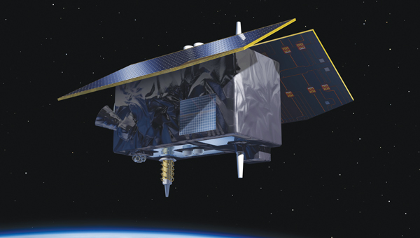
The ITRF will enter a new era with the European Space Agency’s Genesis mission. The mission’s satellite will carry instruments for all four space-geodetic techniques: GNSS, VLBI, SLR and DORIS. In this quarter’s “Innovation” column, a team of Genesis mission engineers and scientists introduce the mission, describe its components and outline its benefits. My well-thumbed copy of the Concise Oxford Dictionary of Current English has two definitions for the word “genesis.” The first, with a capital “G,” is the title of the first book of the Old Testament with its well-known first verse. The second is “Origin, mode of formation or generation” and comes from the Greek word genēs, meaning birth, born or produced. It is clearly a fitting name for ESA’s new mission.
The combination of advanced technologies for precise orbit determination and timing, as well as the scientific exploitation of GNSS signals, opens major new opportunities for relevant, innovative in-orbit scientific experiments. These opportunities come in the fields of Earth sciences, including geodesy, geophysics and GNSS remote sensing of the atmosphere, land, ocean and ice, fundamental physics, astronomy and time metrology. They could extend some current operational applications such as precise orbit determination for geodesy and altimetry and GNSS radio occultation for meteorology and space weather.
To further enhance the benefits of combining space-based geodetic techniques, the European Space Agency (ESA) has established the Genesis mission. The mission will collocate on board a single well-calibrated satellite, the four space-based geodetic techniques: GNSS, very long baseline interferometry (VLBI), satellite laser ranging (SLR) and Doppler Orbitography and Radio-positioning Integrated by Satellite (DORIS). This first-time-ever collocation in space will establish precise and stable ties among these key techniques. The Genesis satellite will be a unique, dynamic space geodetic observatory, whose observations, combined with the measurements using geodetic collocation techniques stations on Earth, will contribute to a significant improvement of the International Terrestrial Reference Frame (ITRF).
The ITRF is recognized as the foundation for all space- and ground-based observations in Earth science and navigation, and therefore this mission will potentially have a major impact on several GNSS and Earth observation applications. It is a particular realization of the terrestrial reference system, and its history goes back to 1984 when the former Bureau International de l’Heure, which was then in charge of maintaining an accessible reference frame, established a frame using space-based geodetic techniques. The tradition was continued by the International Earth Rotation and Reference Systems Service (IERS) when it was established in 1987. The IERS has periodically updated the ITRF incorporating new systems, data sets and analysis procedures. The Genesis mission will help identify any systematic errors in the ITRF and thereby improve the accuracy and stability of the frame, particularly the origin and scale of the frame, which are the most critical parameters for scientific applications.
The Genesis mission was endorsed by the ESA Ministerial Council in November 2022. The mission will be executed under the responsibility of ESA’s Navigation Directorate as an element of the Future Navigation Program in cooperation with ESA’s Operations Directorate.
ESA performed an internal mission feasibility study (a so-called concurrent design facility) in March and April 2022. A team of more than 40 experts reviewed the mission objectives and the possible implementation, derived high-level mission requirements, assessed the necessary mission instruments and their technology readiness level and concluded that the mission is feasible and compatible with the Genesis-defined program boundaries.
GENESIS MISSION OBJECTIVES
The overall mission goal, as defined by the Global Geodetic Observing System (GGOS) initiative of the International Association of Geodesy, is to help achieve an ITRF accuracy of 1 millimeter with long-term stability of 0.1 millimeters per year, to be able to detect the smallest variations in the Earth system solid, fluid and gaseous components.
Figure 1: Genesis mission concept.
The improvements of the ITRF will impact and improve multiple geodetic and geophysical observables, as well as precise navigation and positioning, and strengthen the geodetic infrastructure, including the Galileo constellation, by reducing the systematic biases between different observing techniques.
Furthermore, the Genesis mission will allow us to improve the link between the ITRF and the International Celestial Reference Frame (ICRF) due to improvement in determining the Earth orientation parameters (EOPs). The ICRF is a realization of a quasi-inertial reference system defined by extragalactic radio sources, mostly quasars, billions of light years away. The positions of a set of globally distributed VLBI radio telescopes are determined using the difference in the arrival times of the signals at the different telescopes. The ICRF was established and is maintained through a cooperation between the International Astronomical Union and the IERS.
The ITRF and the ICRF are related through the EOPs, which include pole coordinates, the Earth’s rotation angle typically referred to as Universal Time (and the related length of day), and nutation angles and their rates.
GENESIS MISSION OVERVIEW
Figure 2 Genesis project organization.
The baseline orbit of the Genesis satellite will be circular, will have an altitude of about 6,000 kilometers and an inclination of about 95 degrees. The mass of the satellite will be on the order of 250 kilograms to 300 kilogramsg, and it will have very precise on-board metrology, through a single ultra-stable oscillator. An artist’s conception of the satellite in space is shown in the opening image. The launch is foreseen for 2028, and the baseline duration for operations is two years with an option for extension.
The Genesis mission architecture will consist of the Genesis satellite, a ground control segment constituted by a mission control center and a (network of) ground station(s), a data processing center (including a global GNSS sensor station network), a data archiving and distribution center, and the required ground infrastructure for the VLBI, SLR and DORIS campaigns (See FIGURE 1). The scope of the procurement for this mission is the Genesis satellite, the ground control segment, the launch service and two years of operations with the option for extension.
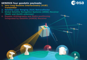
As previously mentioned, the satellite will be launched as the first with all four space-based geodetic techniques on board — namely GNSS, VLBI, SLR and DORIS:
GNSS receiver. This will be a high-quality multi-constellation (Galileo and GPS) and multi-frequency space receiver. The GNSS observations will be of very high quality and will allow multi-GNSS integer ambiguity resolution for the carrier phase with a very high success rate. This instrument is crucial for the very precise orbit determination of the Genesis satellite.
VLBI. This instrument will transmit radio signals compatible with receivers at each observing VLBI station. To eliminate the ionospheric dispersive delay along the paths to each station, different frequency bands will be used. The signals will also comply with the evolving observation procedures at all VLBI stations. The signals will be observed by all geodetic VLBI antennas, including the new VLBI Global Observing System (VGOS) fast slewing stations, in their standard geodetic receiver setups. The transmitter currently under development is designed to transmit at different frequencies between 2 GHz and 14 GHz, but also higher frequency bands can be considered. The present setup for regular VGOS observations use four 1-GHz-wide bands within the S, C and X frequency bands. The unit is designed to transmit both pseudo-noise and random noise. The random noise signal mimics the broader-band noise emitted by quasar radio sources routinely observed by VLBI, and hence can be processed essentially by the usual station and correlator software. VLBI observations of Genesis will enable VLBI stations to be accurately located within the ITRF consistently with the other geodetic techniques, enable a frame tie between the celestial frame and the dynamic reference frames of satellite orbits as well as a frame tie between the ITRF and the extremely accurate and stable ICRF.
SLR. A passive SLR retro-reflector (LRR) will be attached to the satellite in such a way to ensure an adequate field of view when the satellite is in Earth-pointing mode. The SLR observable is the round-trip time of flight of a laser pulse between a ground station and the LLR. Currently, the ITRF long-term origin is defined by SLR, and this is the most accurate satellite technique in sensing the Earth’s center of mass.
DORIS. Genesis will include a DORIS receiver instrument. DORIS is based on the principle of the Doppler effect between a network of transmitting terrestrial beacons and the on-board instrument. DORIS was first featured on the SPOT-2 satellite launched in 1990. Since then, DORIS receivers have been featured on multiple satellites. The integration of the DORIS receiver on Genesis, given the high-precision knowledge of the Genesis orbit, will benefit other space geodetic techniques from the global DORIS network distribution.
All active instruments will rely on a single high-precision compact frequency standard payload, termed the ultra-stable oscillator.
GENESIS PROJECT ORGANIZATION
The Genesis mission is being procured in an end-to-end approach, meaning that the industry prime is responsible for the development of the satellite, including the payload instruments, the launch services and the satellite operations. For this reason, the following approach has been applied: contract signature was in March 2024. Design, development, validation and acceptance will take place between 2024 and 2027, leading up to a planned launch in 2028.
The contract for Genesis amounts to € 76.6 million. A consortium of 14 entities led by OHB Italia S.p.A. has been tasked with developing, manufacturing, qualifying, calibrating, launching and operating the Genesis satellite, including all its payloads. The mission is supported by Italy, Belgium, France, Switzerland, Hungary and the United Kingdom.
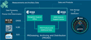
Figure 3 Processing, archiving and distribution of Genesis data and products.
The overall project organization is outlined in FIGURE 2. The ESA Genesis project team, led by the project manager, will manage and coordinate the work of all interfaces among i) the industrial consortium, ii) ESA in its role of handling data processing, archiving and operating the distribution center, iii) the scientific community for whatever the necessary interface is required for the preparation of scientific exploitation and coherency between the project development and the scientific mission objectives.
For the data processing, exploitation, archiving and dissemination of data to the scientific community, the PROcessing, Archiving, exploitation and Dissemination Centre (PROAD) has been set up, (See FIGURE 3), using the European Space Operations Centre (ESOC) Navigation Support Office facilities and the GNSS Science Support Centre (GSSC) of the European Space Astronomy Centre (ESAC).
For the data processing required in advance of scientific exploitation of the data, the ESOC Navigation Support Office facilities will be used. The data processing includes the precise orbit determination for the GENESIS satellite.
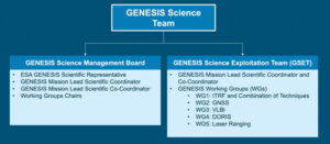
Figure 4 Genesis science team.
Furthermore, after the processing performed by ESOC, ESAC’s GSSC will be used for data archiving and data distribution for scientific exploitation. The PROAD will be set up and coordinated internally in ESA.
The setup and coordination of the required ground infrastructure, VLBI and SLR campaigns, the DORIS network and so on, will be managed by ESA’s Genesis project team together with a Genesis science team (See FIGURE 4).
The science team will also support ESA’s Genesis project team as required in the reviews and follow-up activities, especially with respect to compliance with the mission objectives.
SUMMARY
The Genesis mission is a very challenging one, which has been made possible by the combined effort from the scientific community, ESA member states, industry and ESA itself. The success of Genesis will strongly depend on the interaction, cooperation and support of the international scientific community. The mission objectives of Genesis address core scientific as well as societal aspects. Above all, the Genesis mission is at the foundation level of all positioning and navigation.
ACKNOWLEDGEMENTS
This article has drawn, in part, on the multi-author paper “GENESIS: co-location of geodetic techniques in space,” Earth, Planets and Space (2023), Vol. 75, No. 5, https://doi.org/10.1186/s40623-022-01752-w
onocoy has launched the onocoy real-time kinematic (RTK) service designed to offer positioning capabilities worldwide.
The service utilizes blockchain technology and a decentralized network of reference stations, offering users accurate correction data for applications requiring centimeter-level positioning. onocoy RTK offers global coverage with data quality controls in place to verify correction information before distribution.
According to onocoy, the service offers quick convergence times and high accuracy due to its dense network of reference stations. It outputs data in the standardized RTCM format for integration with various systems.
onocoy RTk targets industries such as agriculture, construction, mining, robotics and autonomous systems that require flexible and reliable high-precision positioning. onocoy says it is also developing business-to-business offerings, including access to station data and customized solutions.
With this launch, onocoy aims to expand access to RTK technology and advance high-precision positioning capabilities across sectors.