Registration is now open for the Institute of Navigation (ION) GNSS+ 2013 to be held September 16-20 (tutorials September 16 and 17) at the Nashville Convention Center in Nashville, Tennessee.
ION GNSS+ 2013 is the26th International Technical Meeting of the ION Satellite Division and the world’s largest technical meeting and showcase of GNSS technology, products and services.
ION GNSS+ brings together international leaders in GNSS and related positioning, navigation and timing fields to present new research, introduce new technologies, update current policy, demonstrate products and exchange ideas. The addition of “+” to the conference name reflects the growing emphasis on GNSS and the rapidly evolving field of alternative navigation methods.
This year’s conference will feature pre-conference tutorials September 16-17, policy and panel discussions, commercial and applications oriented sessions, and more than 250 technical papers on a diverse array of topics including:
Advanced Inertial Sensing and Applications
Advances in Military GNSS Systems and Applications
Algorithms and Methods
Alternatives and Backups to GNSS
Aviation Applications
Clock/Timing and Scientific Applications
Emerging GNSS (Galileo, COMPASS, QZSS, IRNSS) (both a Panel Discussion and a technical session)
Future PNT and Its Applications
Geodesy, Surveying and RTK for Civil Applications
GNSS Algorithms and Methods
GNSS and the Atmosphere
GNSS Compatibility, Interoperability, and Interchangeability
GNSS Ground Based Augmentation Systems (GBAS)
GNSS Simulation and Testing
GNSS Space Based Augmentation Systems (SBAS)
GNSS-MEMS Integration
GNSS Program Updates (Panel Discussion)
GPS and GLONASS Modernization
High Integrity Systems (Panel Discussion)
Indoor Navigation and Timing
Interference and Spectrum Issues
IP Policies Related to GNSS (Panel Discussion)
Land Based Applications
Marine Navigation and Applications
Multi-Constellation/Portable Navigation Devices
Multi-Sensor and Integrated Navigation in GNSS-Challenged Environments
New Products and Commercial Services (both a Panel Discussion and a commercial applications oriented session)
Next Generation GNSS Integrity
Non Traditional PNT Applications
Portable Navigation Devices
Precise Point Positioning
Receiver/Antenna Technology
Remote Sensing with GNSS and Integrated Systems
Safety Critical Applications
Software Receivers
Space Applications
Standalone GNSS Services in Challenging Environments
Timing and Scientific Applications
Unmanned GNSS (Panel Discussion)
Urban Navigation Technology
New this year will be two For Official Use Only (FOUO) U.S. only sessions: Multi-Sensor Integrated Navigation and Networked-Related Navigation. These sessions are sponsored by the ION’s Military Division and The MITRE Corporation.
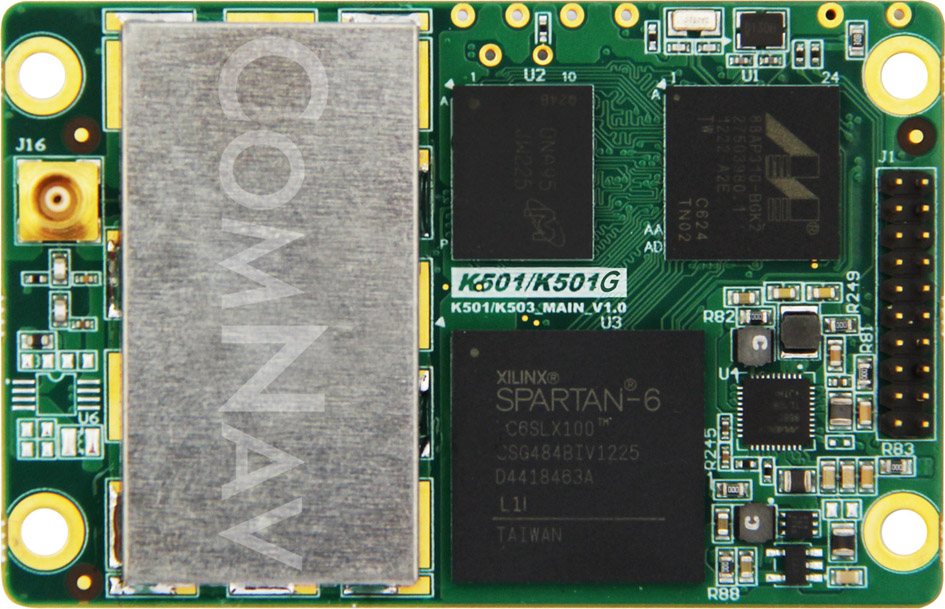
The K501 GNSS OEM board by ComNav is a GPS+BeiDou small-sized OEM board. K501 has advanced dynamic acquisition ability and high-accuracy carrier phase calculating. By using the GPS+BeiDou dual system high-dynamic processing engine, work in difficult environments is easier and RTK positioning accuracy can reach the centimeter level. The hardware size, interface, and data command are compatible with major brand OEM boards.
The K501 GNSS OEM board by ComNav
Features include:
GPS L1/L2+BeiDou B1/B2 dual satellite system calculating
Configurable GPS/BeiDou single-system positioning and GPS+BeiDou dual-system positioning
Compatible with other major brands on physical size, interface and data command
Directly export PJK coordinate
Supports short, middle and long baseline, RTK working distance can reach 50 KM
Easy to customize, can satisfy different kinds of demands
China’s icebreaker Xuelong, or Snow Dragon,returned to Shanghai April 9 after successfully completing China’s 29th Antarctica scientific expedition. As a high-accuracy GNSS solutions provider, ComNav supplied a GPS+BeiDou GNSS receiver for this expedition. This was the first time that the ComNav GNSS receiver worked in such an extreme environment.
The reliable performance of the receiver impressed the expedition team. “The fast-searching satellites speed and the accurate positioning result saved us lots of time in the extreme cold field,” said one team member. It was the first time that a BeiDou receiver was used in the Antarctic, according to ComNav.
The research vessel left the southern port city of Guangzhou on November 5, 2012, for Antarctica. It covered 29,000 nautical miles over its 156-day southern voyage, among which 6,000 nautical miles were in ice regions. A total of 239 researchers on board completed 53 research tasks on biology, ecology, geophysics, ocean, climate, environment and glacier, and engineering construction missions.
Game Golf, a wearable technology and integrated software platform for golf, is available for pre-0rder, and expected to be released this summer. Backed by professional golfers Graeme McDowell and Lee Westwood, it seamlessly records a player’s golf game to make the game more engaging, visual, interactive, shareable and social, both on and off the course.
“Game Golf not only gives everyone access to crucial data to dramatically improve your golf game and handicap, but it also makes playing more motivating, rewarding, social and fun,” said Graeme McDowell, 2010 U.S. Open Champion and Game Golf investor. “The product is extremely intuitive, doesn’t disrupt your game and is essential for any golfer looking to understand their game better, knock down their handicap, give themselves a competitive edge and compete with their friends and family across the globe.”
Game Golf is designed by fuseproject and Yves Béhar, CEO of fuseproject and Chief Creative Officer at Jawbone, the maker of the wireless Jambox speaker. The Game Golf elegant and discreet wearable device tracks the data around the course, and uploads the data automatically to an intuitive app which allows you to track, analyze and share the data collected. It tracks the most important statistics from your golf game, including club-by-club performance, fairway accuracy, greens in regulation and putting.
“The design of the Game Golf app and product has been closely integrated: a beautiful and dynamic presentation of play data, easy and fun ways to share, non-disruptive hardware and experience,” said Yves Béhar, CEO of fuseproject. “The design and user interface is crafted to deliver a 21st-century experience of the game.”
The product uses a combination of positional technology, motion sensors and near field communication to capture the golfer’s data from the course. The device is engineered to be power efficient and extend battery life beyond that of the average smartphone and provides two full rounds of tracking on one charge. Data from the device is synced to the cloud via Bluetooth to a smartphone or via USB to a PC.
“The golf community has been calling out for a product that tracks their game effortlessly, shares results with friends and provides intuitive data with which they can analyze to constantly improve their game — and Game Golf is here to provide that,” said John McGuire, CEO and Co-Founder, Game. “A new era of quantification and gamification is rapidly and radically changing the way we live, work and play. Existing golf technologies only provide technology that helps on the course, but we provide the complete package, giving you everything you need to improve your game and compete before, during and after you take to the course.”
MDA’s Information Systems group has signed a contract valued at $1.7 million with the U.S. National Fish and Wildlife Foundation (NFWF). NFWF is working to protect delicate ecological environments by funding a satellite monitoring pilot program designed to detect illegal discharges of oil from vessels operating in the U.S. Exclusive Economic Zone (EEZ) and to reduce the number of those incidents.
The United States’ EEZ is the largest in the world, spanning three oceans, the Gulf of Mexico, and Caribbean Sea. It routinely has thousands of vessels traversing its area. With remote locations that are difficult to access, massive areas to monitor, and thousands of vessels to screen, deterring the illegal dumping of oil by boats at sea is a significant challenge. To help solve this problem, NFWF has partnered with MDA to develop a comprehensive satellite-based solution for marine environmental monitoring.
Building on extensive global experience providing ship and oil detection, MDA’s RADARSAT-based wide area monitoring solutions form the core of the initiative and are ideally suited for this type of program, MDA said. To complement the RADARSAT-based solutions, MDA has assembled Automatic Identification System (AIS), Synthetic Aperture Radar (SAR) and optical satellite sensors from the leading geospatial providers to deliver a versatile solution for maritime domain awareness.
The monies for the monitoring program originated from community service funds directed to NFWF following to a sentence issued in the successful prosecution of an environmental crimes case involving the illegal dumping of oil from vessels, the bypassing of onboard pollution prevention equipment, and improper oil record-keeping. Over the course of the 18-month program, MDA and NFWF, in consultation with the U.S. Coast Guard, will coordinate to develop a detailed monitoring plan. In executing this plan, MDA will identify possible oil pollution sources. Trained analysts will review the satellite-based information and produce a report with the analysis of location, timing, amount, and source (naturally occurring seep vs. vessel-sourced oil).
When man-made spills are identified, MDA’s maritime domain awareness solutions help authorities identify the source of the spill and the responsible operator. For vessels that are caught illegally polluting, the U.S. government can impose significant fines that will act as a deterrent. From the information generated by this program, monitoring baselines will be developed for future programs that are designed to help promote environmental compliance within the U.S. EEZ and to prevent these environmental crimes from recurring.
Abstract submissions are now being accepted for the Institute of Navigation’s (ION) Precise Time and Time Interval Meeting (PTTI). The conference will take place December 2-5 (Tutorials December 2) at the Hyatt Regency Bellevue, Bellevue, Washington. The deadline for submitting abstracts is August 2.
Instructions on submitting your abstract can be found at www.ion.org/ptti
PTTI is an annual conference sponsored by ION with a technical program designed to disseminate and coordinate PTTI information at the user level, review present and future PTTI requirements, inform government and industry engineers, technicians, and managers of precise time and frequency technology and its problems, and provide an opportunity for an active exchange of new technology associated with PTTI.
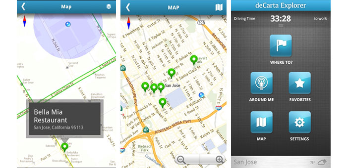
deCarta, Inc., an independent LBS technology company, has introduced its Xplorer V8 navigation platform, combining deCarta’s cloud-based navigation service with customizable client-side libraries. This combination gives application developers the ability to quickly add vector mapping and turn-by-turn navigation to any mobile application, from local search to fleet management, providing users with fast, accurate driving directions to a destination or search result.
Xplorer V8 is available as a white label application or as client-side libraries depending on the degree of customization required. deCarta’s L2 advanced local search technology is fully integrated into the platform to help users find destination addresses or local points of interest (POI).
deCarta navigation technology powers products such as GM OnStar, Ford Sync, INRIX, Appello, TCS and MotionX GPS Drive. With Xplorer V8, deCarta lets developers tightly integrate that functionality into their own applications or to build custom navigation applications. Examples of the use of Xplorer V8 include:
Local search applications that offer route guidance to the search destination from a mobile phone or tablet.
Branded navigation applications for global automotive companies.
Mobile applications that display places of interest in a vector map display with smooth panning, rotation and zooming.
Fleet management solutions that offer route guidance and tracking to ensure that drivers are directed efficiently to their destinations.
deCarta has already engaged with customers in each of these areas and expects to be announcing new partners for Xplorer V8 in the coming months.
The Xplorer V8 platform consists of a cloud-based service and a set of core client-side libraries that work together to provide a high-quality navigation experience.
The Xplorer V8 Navigation Cloud Services provide local search and navigation response based on deCarta’s geospatial technologies. deCarta hosts these services in global data centers in Santa Clara, London, Seoul, Beijing and Sydney.
The Xplorer V8 CoreLibraries are integrated into client side applications. They support three critical functions that can be used together as a group or individually as needed by the customer.
Local Search: Single line search and geocoding based on deCarta’s L2 technology.
Guidance and Routing: Voice guided navigation, displayable as an overview, a list of directions or in turn-by-turn sequence.
Map Display: Vector-based maps that support turn-by-turn navigation, voice guidance, 3D display, immediate off route determination and rerouting.
Xplorer V8 libraries are compatible with all Android-based platforms for mobile devices, tablets and automotive embedded systems. Apple iOS versions will be available at the end of June.
For companies interested in a turn-key navigation solution, Xplorer V8 is also available as a white-label navigation application that can be branded to match the customer’s needs.
“Industrial-grade navigation engines are extremely hard to develop. To meet the demanding consumer expectations, they have to perform well, with speed and accuracy across a wide range of circumstances,” said J. Kim Fennell, CEO of deCarta. “Xplorer V8 packages all of deCarta’s navigation experience and makes it available for application developers to integrate directly into their apps.”
Xplorer V8 is available immediately for deployment in North America and Australia, with Western Europe coverage coming in June. Other countries will be included in the following months.
Raytheon Company has completed delivery of more than 200 Paveway GBU-50 guidance kits to a European partner.
The GBU-50 provides the 2,000-pound MK-84 or the BLU-109 penetrator with all-weather GPS navigation combined with precision terminal laser guidance. A full range of selectable terminal impact angles combined with a mature combat-proven, height-of-burst maximizes the capabilities of both the MK-84 and BLU-109.
“This delivery is a significant milestone for the Enhanced Paveway II program as it provides unique capabilities to our allies,” said Harry Schulte, vice president of Raytheon Missile Systems’ Air Warfare Systems. “As we begin our second production run of the GBU-50, we have substantial interest from the international community.”
Each Enhanced Paveway II guidance and control section is compatible with warheads ranging from the 250-pound MK-81 to the 2,000-pound MK-84 along with the BLU-109. There is no need for the warfighter to acquire a different guidance and control section for different warhead use.
According to Raytheon, the Paveway family of laser-guided and GPS and laser-guided bombs, has revolutionized tactical air-to-ground warfare by converting “dumb” bombs into precision-guided munitions. Paveway laser-guided bomb kits comprised more than half the air-to-ground precision-guided weapons used in Operation Iraqi Freedom, Enduring Freedom and Unified Protector.
Telit Wireless Solutions, provider of high-quality machine-to-machine (M2M) modules, services and solutions, has announced approval by Sprint for its CE910-DUAL cellular M2M module. A dual-band CDMA 1xRTT module, the CE910-DUAL allows Sprint M2M Solutions customers to deploy a wide range of M2M applications benefiting from reliable connectivity over Sprint’s nationwide network while enabling cost-sensitive business plans.
The CE910-DUAL packs high value features in its ultra-compact 28.2 x 28.2 x 2.04 mm Land Grid Array (LGA) package. USB 2.0 full-speed support and a rich set of drivers make it ideal for embedded applications requiring easy integration to platforms based on the latest desktop and mobile operating systems such as Windows and Linux. Full-duplex data rate of 153.6 Kpbs and extended operating temperature range of -30°C to +85°C make it a suitable platform for mobile and fixed applications such as vending, point-of-sale (POS), tracking, smart metering, and telematics devices.
“Sprint plans to maintain our CDMA 1xRTT network capability for the long term as part of our overall Network Vision strategy,” said Wayne Ward, vice president, M2M Group, Sprint. “We have been working with Telit for several years as a Sprint preferred provider and one of the leading module suppliers to the M2M industry and believe their xE910 form factor makes it easy for customers to deploy on either the EV-DO or 1xRTT CDMA Sprint networks.”
“With this approval, the cost-effectiveness, reliability and functionality of the CE910-DUAL module are accessible to Sprint M2M and Telit customers along with outstanding support and network connectivity from one of the nation’s top-rated cellular networks,” said Mike Ueland, senior vice president and general manager of Telit Wireless Solutions North America.
Part of the xE910 form factor family, the CE910-DUAL protects investments by offering complete compatibility with the DE910-DUAL, a Sprint-approved companion product for EV-DO Rev. A applications.
u-blox, provider of wireless and positioning semiconductors, software and solutions, announces that its LISA-U200 and LISA-230 6-band UMTS/HSPA+ module series as well as LISA-U270 dual band module has achieved Certified M2M Hardware status by Vodafone, the world’s second largest mobile telecom company. Vodafone owns and operates networks in more than 30 countries and has partner networks in over 40 additional countries.
The certification allows global customers to design LISA-U2 modems into M2M devices operating over Vodafone’s extensive 3G network in Europe, Asia, Africa, Australasia and the Americas. Main applications include vehicle and asset tracking, industrial automation, metering, and security devices.
The LISA-U2 series is a multi-band 3G module series in LCC package delivering high data-rates (5.76 Mb/s uplink and up to 21.1 Mb/s downlink) with voice and data capabilities. They are compatible with consumer, automotive and industrial applications. For telematics applications such as fleet and asset management, the module provides easy integration with u-blox GPS, GLONASS and QZSS receivers. The modules are compatible with all UMTS bands used worldwide.
Polaris Wireless, a high-accuracy, software-based wireless location solution company based in Mountain View, California, today announced that the company closed on a recapitalization of existing equity interests on April 25, 2013. As part of the recapitalization, Polaris Wireless completed a Series C financing with $10 million from Industry Ventures, a leading investment firm focused on the venture capital market, and Industry Ventures Managing Director Victor Hwang has joined the Polaris Wireless Board of Directors.
“Industry Ventures seeks to invest in market leading growth companies and we believe Polaris Wireless is a clear leader in the wireless location market,” said Hwang. “We are very excited about Polaris Wireless’ strong growth trajectory and global presence, and look forward to working with Manlio Allegra and the senior team at Polaris Wireless in their next chapter of growth.”
The investment by Industry Ventures also returned capital to Series A investor Draper Fisher Jurvetson (DFJ) and will also be used to fund Polaris Wireless’ future international growth.
“We look forward to an exciting new growth chapter for our company with Industry Ventures by our side,” said Manlio Allegra, Polaris Wireless CEO and Co-founder.
Polaris Wireles experienced a record increase in revenue and profitability in 2011 and 2012, driven by aggressive growth for its location solutions across the globe. Twenty-four U.S. wireless carriers, six managed services partners, and 15 international deployments now rely on Polaris Wireless location solutions to enable emergency call applications, lawful and mass location surveillance, and other location-based services.
It used to be that if you were going to build an RF navigation receiver, you had to also build your own simulation system to test it. I remember working with a couple of “home-built” RF simulation systems myself, way back when. We experience a lot of maintenance and support issues. And, of course, if you build something and also build something to test it, its likely that incorrect assumptions will end up in both systems. Today, there are a number of excellent sources for GNSS simulation equipment and support you can buy on the open market.
The spectrum of today’s providers seems to range from highly sophisticated scientific systems used for development by precision receiver manufacturers, through systems with GNSS and aiding solutions, to specialized systems for both general and specific application developers and also for production test. So this month I’d like to try to summarize (in no particular order) what some of the suppliers of GNSS simulation systems are up to, how they may be positioned in the market and, wherever possible, what we might expect to see from them in the future.
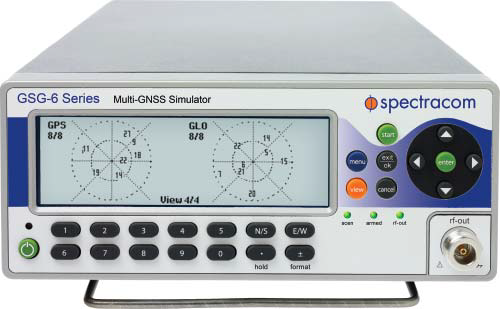
GSG Series 6 GNSS simulator.
Spectracom is a more recent entrant to the GNSS simulation market, though the company has been providing frequency and time synchronization test equipment for about 40 years. Spectracom has integrated GPS into these products for more than ten years, and decided three years ago to use the knowledge it had gained to get into the GNSS simulation business.
The GSG family of simulators is positioned at the “affordable” end of the simulation equipment scale, and is targeted at users and integrators of GNSS, rather than developers of receivers. Spectracom claims to have about 80 percent of the features of the top-end simulations systems, but its more capable (Series 6) systems sell in the $20-30k range. While new to the business, the Spectracom team feels that this allows them to bring the newest technology and innovation to the market.
The Spectracom system is derived from its well-known frequency/time synthesizer equipment — in fact, it has the same look front panel and chassis — and also makes use of the same “easy-to-use” concepts. “It doesn’t take a navigation scientist to operate these simulators,” said John Fischer, chief technology officerat Spectracom. The accompanying Studio View software is reportedly relatively easy to use to generate trajectories and other test scenarios by connecting to Google Maps and uploading them to the simulator.
But with all new firmware and FPGA implementation, 64 channels, and four frequency bands covering both GPS and GLONASS, the GSG family appears to be very well positioned for application developers integrating GNSS. Galileo and Beidou/Compass are in the works and expected this year, and will be supplied as upgrades to existing equipment.
Spectracom anticipates significant growth in its target market for application developers in “anything that moves,” including automotive and airborne, video matching, radar/lidar, and handheld nav devices, including mobile phones. Spectracom has a number of product lines and around 100 people working for them, but the GNSS simulation group is around 12 strong.
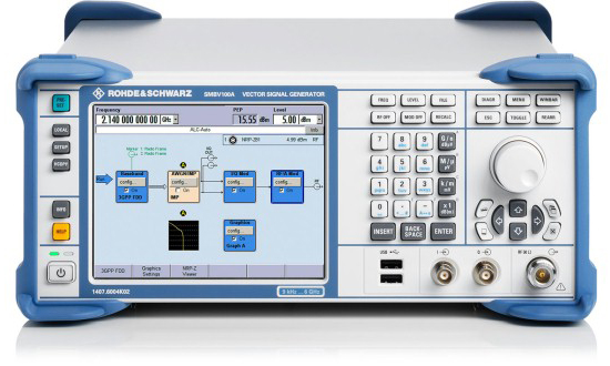
Rohde & Schwarz is another relatively recent GNSS simulation entrant with new products for the market.
SMBV100A vector signal generator.
Its current offering — the SMBV100A Vector Signal Generator – can simulate 24 dynamic GPS, GLONASS and Galileo satellites. The SMBV 100A has wide bandwidth and high output power levels. Real-time test scenarios can be customized by the user — including a neat facility that allows modeling of satellite masking by downtown buildings, along with anticipated multipath for the same urban scenario.
While somewhat new to GNSS simulation, R&S has been around since the 1930s, and its experience with frequency synthesizers and similar equipment is being carried forward into what the company terms its “cost-effective” GNSS simulation offerings. R&S anticipates significant growth in automotive, aerospace, UAV, and cellular assisted-GNSS application markets.
R&S has had success in the aerospace market for UAVs, and has developed the capability to model antenna patterns and UAV body mask as the vehicle rotates and attitude changes towards visible satellites. Along the same lines, R&S has hooked up its system to flight simulators and provided hardware-in-the-loop testing for clients. R&S also has the ability to run simulation scenarios for long periods of time, and for “very long” periods if the receiver is stationary — this feature makes use of large internal memory storage within the SMBV100A; of course, almanac validity limits just how long this is possible. P-code capability is provided as an option, and there is a roadmap for adding SBAS and Beidou capability later.
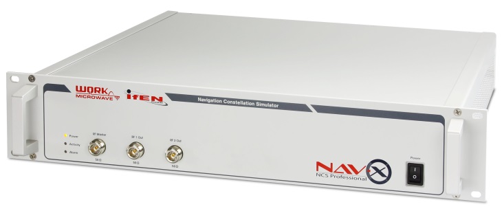
IFEN NavX-NCS Professional
In the meantime, IFEN in Germany is focusing on its NavX-NCS Navigation Constellation Simulator range of multi-GNSS signal simulators.
IFEN emphasizes the flexibility of its design, with a platform scalable from a 12-channel GPS L1 system up to a full multi-GNSS system with 108 channels and 9 frequencies for GPS, GLONASS, Galileo, QZSS and SBAS. With this building-block approach, channels and capabilities can be added as and when additional testing complexity is required.
IFEN claims that the capability to generate all GNSS signals — by combining different modulations with up to nine L-band frequencies — is the only existing solution on the market providing GPS, Galileo, GLONASS, QZSS and SBAS in one chassis at the same time. And, since April 2013, all IFEN NavX-NCS GNSS RF signal simulators are to include BeiDou B1 signal capability in accordance with the official Chinese BeiDou B1 ICD, and are ready for the other B2 and B3 BeiDou signals.
IFEN also founded a subsidiary in the USA in January this year called IFEN, Inc., located in California and operational with Mark Wilson (formerly with Spirent) as VP Sales. In addition, IFEN has formed a partnership with WORK Microwave — a leading European manufacturer of advanced satellite communications and navigation equipment. WORK Microwave is responsible for RF and digital hardware design while IFEN develops the associated software and manages the distribution of the product range.
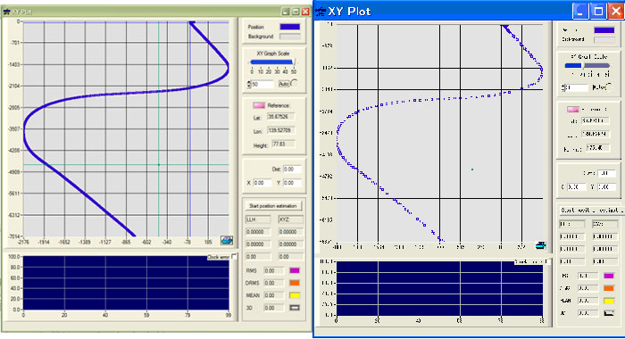
Little-known IP-Solutions in Tokyo, Japan, has been working to develop its ReGen GNSS DIF signal simulator, a software simulator that simulates ionospheric effects, generates digital IF (DIF) signals similar to those recorded by an RF recorder, and comes with an optional capability of simulating integrated inertial navigation.
IP-Solutions’ digital IF baseband signal simulator ReGen has been developed in close cooperation with the Japan Aerospace Exploration Agency (JAXA) to test and validate GNSS signal processing algorithms and methods for use on board aircraft using tight and ultra-tight integration with INS, including specific scintillation models and ionospheric bubble simulation.
Actual recorded flight data (left), ReGen replicated flight data (right).
Various configurations of ReGen can produce multichannel GPS and GLONASS L1 signals and single-channel GPS L1, L2, L5 and GLONASS L1 and L2 signals, as well as simulating noise and interference.
Meanwhile, Spirent, arguably the original market leader in GNSS simulation, has continued along its chosen path of supplying the industry with the greatest capability and most extensive simulation systems.
Spirent has recently released test systems with support for China’s BeiDou Navigation Satellite System in addition to GPS, GLONASS and Galileo.
Spirent started shipping BeiDou-ready systems to its customers in 2012. Now these may be upgraded to full BeiDou capability using the information available in the first full issue of the BeiDou-2 Signal In Space Interface Control Document (ICD).
Also aiming at mobile applications, Spirent’s Hybrid Location Technology Solution (HLTS) integrates Wi-Fi, Assisted Global Navigation Satellite System (A-GNSS), Micro Electro-Mechanical Systems (MEMS) sensor and cellular positioning technologies. HLTS integrates four very different and distinct location technologies and provides repeatable and reliable lab-based characterization of mobile devices supporting hybrid location technologies that will enable “accurate everywhere” location — including indoor user location determination.
Other notable players in the GNSS simulation business include Racelogic, CAST Navigation and Agilent who are each pursuing their chosen niches in this expanding market segment. Racelogic’s LabSat GPS simulator is gaining popularity with a number of leading companies, providing the ability to record and replay real GNSS RF data as well as user-generated scenarios. CAST has an extensive line-up of GPS and GPS/INS simulation systems and support software, and Agilent has added to its impressive electronic testing portfolio with a very capable looking GPS simulation product line.
Several other companies — some based in China and Russia — are also trying to figure out their development and marketing strategies to conquer their chosen GNSS simulation market niche. This is all a very healthy sign that there are many other companies with new embedded GNSS applications that they are bringing to market and who therefore need GNSS simulation/test capability. Overall, this means there is still significant growth underway and far wider applications of GNSS on their way to market. Great news for the GNSS industry!