oneNav has released the results of a test evaluating the resilience of its technology to widespread GPS interference. The testing was conducted in and around Haifa, Israel and focused on the performance of its L5-direct GPS receiver compared to GPS receivers in top smartphone and smartwatch brands.
For this test, oneNav compared its L5-direct GPS receiver to receivers found in iPhone, Samsung Galaxy and Google Pixel smartphones and Garmin watches. While these receivers all experienced navigation failure due to GPS interference, oneNav’s L5-direct test solution maintained accurate location fixes despite active jamming and spoofing.
This resilience is due to L5-direct’s ability to directly acquire L5 GPS signals and bypass the L1 GPS signal, which was first invented more than 50 years ago. While current commercial GPS receivers in smartphones, car navigation systems, and airplanes can process the L5 band, they can only do so in a hybrid system that must first acquire L1.
According to the company, L5-band signals are 30 times harder to jam and interfere with than L1 and offer improved performance in difficult-to-navigate areas such as urban canyons and tree-covered regions.
“We now have clear, indisputable evidence that L5-direct is resilient to widespread GPS jamming and can provide precision location in GPS-contested environments,” said, Steve Poizner oneNav CEO. “This test is a real-world validation of our first-of-its-kind technology and shows the potential for L5-direct to revolutionize how we use GPS for civilian and military purposes in Israel and globally.”
While the field testing took place in Israel, GPS interference is a global security concern due to the increase in attacks on GPS systems worldwide. In Ukraine, Russia is countering American-made smart weapons on the battlefield through GPS-jamming technology and is accused of interfering with GPS navigation systems in more than 46,000 flights across Europe.
oneNav’s IP core is available for evaluation and integration by select chip developer partners and its low-SWaP chips and modules will soon be available for select partners. L5-direct is compatible with all GNSS constellations.
The U.S. Army has released a Request for White Papers (RfWP) to develop new C5ISR modular open Suite of standards (CMOSS) mounted form factor (CMFF) prototypes.
Through CMFF, the Army aims to easily and rapidly equip ground vehicles and aviation platforms with positioning, navigation and timing (PNT) and electronic warfare (EW), through capability cards plugged into a common chassis.
The chassis, which offers power, networks and radio frequency, allows Soldiers to “plug and play” capabilities right into the vehicle without the need to custom install and upgrade individual communication and computing systems.
In this prototype effort, the key needs are to develop, procure and furnish the Army with the CMFF chassis, also known as Mounted Common Infrastructure (MCI), plus the smart display for user interface, hardware development, software development and Plug-In Cards with the following capabilities:
Converging tactical communication waveforms.
Mission Command applications.
Assured Positioning, Navigation, and Timing (APNT.)
Force Protection capabilities.
The Army plans to award a contract using the Other Transaction Authority (OTA) with system of system and prototype integrators to provide the complete CMFF system offerings. Industry partners who respond to the RfWP will have an opportunity to showcase the fully functional CMFF system at a technology demonstration in late summer 2024.
“The power of the true concept is when you can take a chassis and put it in another vehicle and you can mix and match cards,” said Col. Shermoan Daiyaan, project manager for Mission Command. “That’s when you’re following a standard. You’re matching a standard, and it just works.”
Jamie Marraccini, president and CEO of Inertial Labs, met with GPS World Editor-in-Chief, Matteo Luccio, to discuss Inertial Labs’ latest IMU technologies for challenging environments.
In October 2023, the United Kingdom’s government announced a 10-point “policy framework” to greatly increase the nation’s resilience to disruption of vital positioning, navigation and timing (PNT) services.
Two months later, Vladimir Putin began regularly jamming and spoofing GPS for aircraft and ships across a broad swath of the Baltic and northern Europe. It was the world’s first instance of such extensive activity in the absence of armed combat.
Properly executed, Britain’s policy framework will position it as a global leader in sovereign and resilient PNT. It will also provide ample new business opportunities for British businesses to fill this growing need.
The product of years of effort under both Coalition and Conservative governments, the PNT policy framework addresses challenges that have been extensively documented and studied.
The nation’s over-reliance on space- based PNT has long been recognized. Its National Risk Register listed solar activity as a threat to PNT in 2012. When, despite extensive lobbying by the UK, the rest of Europe shut down its Loran transmitters in 2015 to prevent competition with Galileo, Britain kept its single transmitter on air as a national precise time reference. In 2018 a “Blackett Report” documented the nation’s over-dependence, estimated the consequences of service outages and made a series of recommendations. A 2021 economic report further estimated the scale of the problem.
All this well before Russia’s demonstrations of the fragility of GNSS with its attacks on Ukraine and recent aggression in the Baltic.
Yet action on Britain’s way forward was repeatedly deferred.
The sticking point seems to have been deciding upon the mechanics of how the government would deal with the invisible PNT utility, which is a capability essential to every government department and every sector of the economy and society. Should it be in the Department for Transport? Perhaps in Business and Trade or Defence? Some suggested the Cabinet Office should lead addressing the PNT challenge.
The final decision was a cross- government office hosted by the Department for Science, Innovation and Technology. The office includes members from the Ministry of Defence and is tasked with leading and coordinating a whole-of-government approach.
Moving Forward
It is easy to be skeptical about the success of this new enterprise. Regardless of the nation, government policy frameworks, strategies and the like often can be a way for politicians and bureaucrats to create the impression of action without having to ever really do anything. Documents are often published and then go on a shelf, never to be seen again.
That does not seem to be the case here, though.
The very first action item in the PNT policy framework is to “[e]stablish a National PNT Office …to improve resilience and drive growth with responsibility for PNT policy, coordination, and delivery.”
While several of the 10 items begin with “develop a proposal for…,” the projects are both considered and specific, such as a timing system “of last resort” for the Ministry of Defence and the expansion of eLoran.
Britain’s integrated governance and system-of-systems approach to PNT can make the nation virtually immune to the kinds of disruptions and infrastructure challenges being seen in the Baltic and conflict zones around the world.
Achieving that goal will involve the development of new user equipment, systems to prioritize and integrate different PNT sources, new interfaces for various infrastructures, improvements to existing technologies (e.g., an encrypted component for eLoran to make it even more secure and reliable), and new policies for responsible PNT use in critical applications.
When complete, the UK will have the sovereign and resilient PNT it needs to support national, homeland and economic security.
Global Leadership and Profit
Yet Great Britain is not the only nation over-dependent on fragile PNT signals from space provided by others. Most of the world is in the same situation.
By actively promoting and sharing its developing expertise and tech stack, the UK will become a global thought leader and technology provider for sovereign and resilient PNT. A capability that will be in greater and greater demand as malicious actors, both large and small, continue to exploit the weaknesses of satellite-based navigation and timing.
Yet, to realize these benefits, the UK must act swiftly and seize the moment.
At present there is a leadership vacuum in this field. While China has its own extremely robust and integrated PNT system based on a combination of clocks, fiber, terrestrial broadcast eLoran, and space, it does not seem eager to export that to others. China may prefer to woo nations into dependence on its BeiDou satellite PNT system, rather than enabling others’ sovereignty.
Additionally, while entrepreneurial South Korea has implemented its own space-based, eLoran and fiber PNT, it is unclear how integrated the various sources are. We have also seen no evidence that they have plans to share, or sell, their success to others.
As disruptions to GPS and other GNSS continue to increase around the globe, so, too, do calls for and moves toward solutions that include alternatives.
Last year the European Union issued a tender for an integrated GNSS/eLoran receiver. Türkiye has implemented its own local terrestrial PNT systems in several port and urban areas. India envisions expanding its regional navigation satellite system to cover the globe.
Britain has the plans, capability, and resources to become the world leader in this essential and growing technology sector — and the government is working with the Royal Institute of Navigation and other learned bodies to make it a reality.
Yet its window of opportunity may already be closing.
Rather than regarding its PNT policy framework as a routine item of work, we hope the UK government seizes this opportunity for international leadership and reaps all the inherent diplomatic, security and economic benefits.
At ION JNC 2024, GPS World Editor-in-Chief, Matteo Luccio, met with Mark Glover, sr. director of business development and assured PNT at AEVEX Aerospace. Glover discussed AEVEX’s new anti-jamming and spoofing technologies and more from the show.
Anna Thorpe, marketing manager at Spirent Federal Systems showcases Spirent’s new PNT X simulator. This simulator is specifically designed for navigation warfare testing.
Swift Navigation and Bad Elf have partnered to deliver a complete, turnkey solution for high-volume and high-precision GIS data collection. GIS data allows workers across industries to create precise digital maps to improve worker safety and efficiency in construction, utilities and environmental management.
By combining BadElf’s GNSS receivers with Swift’s precise positioning solutions, field teams can capture centimeter-accurate location data on a tablet or smartphone Field teams can now more quickly and safely perform maintenance, dig trenches and avoid hazards such as high-voltage wires. wires.
Swift’s Skylark Precise Positioning Service is a cloud-based GNSS corrections service that enables accurate and reliable positioning for location-based products worldwide. Skylark is offered in multiple variants for multiple use cases, each with varying requirements for accuracy, coverage, power consumption and cost.
Bad Elf is a provider of GNSS receivers built for modern GIS mapping applications. Bad Elf’s line of Flex and Flex Mini receivers stream location data to any Bluetooth-equipped device, including Apple, Android, and Windows. When paired with Skylark, Bad Elf receivers deliver accuracy down to one centimeter and a fix within seconds. The combined solution is ideal for field workers requiring reliable high-accuracy positioning.
Trimble and Esri have extended their partnership to enhance collaboration in geographic information system (GIS) software, location intelligence and mapping. This ongoing effort aims to improve processes, support decision-making, and automate workflows for greener infrastructure planning, construction and operations for users.
The companies are exploring emerging technologies, particularly in industry data models that support accurate generative AI technologies and workflows. Trimble’s geospatial field systems, which collect location intelligence and 3D datasets, are enhancing workflow support in Esri ArcGIS Indoors and the ArcGIS Utility Network.
Trimble Unity — a new asset lifecycle management suite — leverages Esri’s GIS into construction project and capital planning, enterprise asset management and permitting solutions to improve how universities, healthcare facility operators, utilities and federal, state and local government jurisdictions track the asset management lifecycle.
Trimble and Esri also partnered with The HALO Trust, the world’s largest landmine-clearing non-profit organization, which combined Trimble’s high-accuracy mapping technology with Esri’s ArcGIS software to improve the capacity to locate and remove landmines and other explosive hazards, making communities safer.
Inertial Labs has integrated its RESEPI lidar solution into ideaForge UAVs. The integration seeks to improve lidar mapping capabilities and is suitable for mining, forestry, geographic information system (GIS) and land surveys, water resources management and more.
The UAVs equipped with RESEPI offer a vertical accuracy of 2 to 3 cm. The precision is maintained at 2 to 4 cm and it excels at a flight height of 50-100 m. The integration enhances the capabilities of ideaForge UAVs, offering users accurate and reliable data for mapping and surveying applications.
The Air Force Research Laboratory (AFRL) has sponsored the development of two unmanned vehicles aimed at accompanying and augmenting the capability of today’s front-line fighter/bomber aircraft. The Loyal Wingman story just took another step forward with the first flight of the General Atomics Aeronautical System Inc. (GA-ASI) developed X-67A at the company’s Gray Butte Flight Operations Facility near Palmdale, California.
General Atomics/AFRL X-67A in flight (Photo: Air Force Research Laboratory Public Affairs)
Little is currently known about the AFRL/GA-ASI unmanned aircraft, other than indications that it has been developed under a Collaborative Combat Aircraft (CCA) program and built on a common frame, which is intended to aid the rapid development of future new variants.
AFRL has previously sponsored Kratos to develop the XQ-58A Valkyrie, which is also intended to “work in teams with manned aircraft,” as a low-cost “attributable” asset commanded by a manned flying companion. The aircraft launches by rocket assist and is recovered vertically by parachute – the new ‘trolley’ launch capability allows the jet-powered Valkyrie to take off on a regular runway.
In earlier flight testing, communications between Valkyrie and both an F-22 Raptor and an F-35 Lightening front-line manned aircraft were established, demonstrating the manned/unmanned teaming concept. With a range of roughly 3,000 mi and an operational ceiling of 44,000 ft, the Valkyrie is intended to demonstrate how an armed, low-cost UAV can bring significant additional assets into combat situations. However, the original test article is now retired and has been put on display at the National Museum of the USAF in Dayton, Ohio, so its demonstration days appear to be over.
XQ-58A Valkyrie. (Photo: AFRL)
Nevertheless, Kratos has built several other production Valkyrie UAVs, which are reportedly undergoing tests with the US Airforce, Marines and Navy. Reports indicate that an XQ-58B electronics defense suppression version has been developed and demonstrated, along with other aircraft that have demonstrated weapons release from an internal stores bay, along with an intriguing release of a small UAV from that same internal bay.
Boeing’s Aurora Flight Sciences has just launched the Skiron-XLE Class 2 UAV – Class 2 meaning that it’s small enough to fit in the back of a pick-up truck. It was derived from an earlier Skiron-X version, which had a wingspan of 16 ft, a length of 7 ft, a weight of less than 50 lb and a meager range of only 8 mi.
Skiron-XLE. (Photo: Aurora Flight Sciences)IE-Soar-800W fuel-cell and regulator. (Photo: IE)
Aurora has now come up with a way to extend the range of the vertical take-off and landing (VTOL) UAV by up to 47 miles and increase endurance from 3 hours to more than 5 hours. This was made possible by replacing the original battery power source on the Skiron-X with a compact hydrogen fuel-cell on the XLE supplied by Intelligent Energy (IE). The Skiron-XLE can be equipped with a gimbal mount electro-optic infrared (EO/IR) sensor and is aimed at the military/security reconnaissance role.
When fuel-cells are mentioned, some people may still think of the liquid oxygen/hydrogen sphere that blew up Apollo 13. Fortunately, however, technology has moved on significantly since this less commercial design of the 1960s. As an example, according to the company’s spec sheet, the Department of Transportation (DOT) certified IE-Soar-800W fuel-cell and hydrogen regulator offers 400 w for up to 5.9 hours. Hydrogen/oxygen gasses are combined across two semi-permeable membranes to generate power — no frozen gas-slush stirring is required.
Meanwhile, progress towards eVTOL air-taxi capability took a step forward for Archer and its Midnight aircraft. Stellantis has invested an additional $55 million into Archer’s efforts to build production capacity for up to 650 aircraft per year at its planned 350,000 sq ft facility in Georgia, scheduled to be completed in 2024.
Archer’s Midnight eVTOL. (Photo: Archer)
To clarify Stellantis’ background – the company includes manufacturers Fiat-Chrysler and Peugeot, which have merged to form the fourth largest vehicle company by sales behind Toyota, Volkswagen and Hyundai. Stellantis has a strategic funding agreement with Archer and the latest investment follows the milestone first test flight of Midnight where the successful transition from vertical lift to forward flight was achieved. The European conglomerate has also acquired up to $110 million in Archer shares on the open market and through this funding initiative.
Stellantis is working with Archer to bring its manufacturing expertise to the fabrication of Archer’s composite air taxi. High-volume car manufacturing and eVTOL building have a lot in common, and there is clearly common interest for a giant car company to gain access to the new eVTOL market.
To recap – GA-ASI has joined the CCA team with the first flight of the AFRL X-67A unmanned UAV, while Kratos continues with further testing of the Valkyrie CCA UAV with several U.S. forces. The latest generation of hydrogen fuel-cells is now extending the range and endurance of Aurora’s Skiron-XLE, while more investment flows in the eVTOL air taxi market.
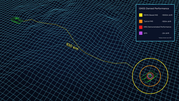
When a vehicle passes through a GNSS-denied area, its navigation system might be thrown off and report an incorrect position. Conversely, INS is inherently subject to drift — the steady accumulation of errors — and therefore must be periodically re-initialized by an external source, such as GNSS. (Photo: Safran Federal Systems)
The term “original equipment manufacturer”(OEM) is widely used, yet vaguely described. In general, an OEM product is one that a company creates and sells to be integrated into systems made by other manufacturers.
In the GNSS industry, the purchasers of OEM products typically are manufacturers of products that require precise positioning or navigation capabilities, from precision agriculture, to surveying and mapping, to UAV missions. Often, manufacturers integrate the OEM GNSS receivers with other sensors, such as inertial measurement units (IMUs) and lidar devices.
A large portion of the OEM business goes unnoticed by the end users of the equipment that utilizes OEM components. These components, such as a guidance system, are often hidden from view, due to being housed under a hood or elsewhere deep within the system.
In the following case studies, OEM products complement GNSS in air, land and marine applications. Safran Federal Systems’ INS for land vehicle navigation and Septentrio’s AIM+ anti-jamming and anti-spoofing technology tackle land and air-based defense applications, while an OxTS IMU is used in a coral reef restoration project to accurately record ship motion.
Land vehicle navigation in GNSS-denied environments
Safran Federal Systems
Ground vehicles in defense operations often navigate in challenging environments where traditional GPS signals are contested or unreliable. This includes dense urban areas, heavily forested regions, or any areas where enemies employ electronic warfare to disrupt GPS signals. Having a robust navigation system that can provide both the vehicle’s location in real time as well as its precise orientation and direction/heading is crucial for defense applications. An inertial navigation system (INS) can provide reliable position and heading data for short periods of time or distances without the aid of GPS satellite signals, allowing vehicles to stay on course and maintain awareness of their location.
Precise location and navigation capabilities are essential for mission planning, execution and coordination with other units. Inaccurate navigation can lead to mission failure, unintended engagements, or even friendly fire incidents.
Geonyx INS
Safran’s Solution
Geonyx INS with incorporated M-Code capability
Safran has developed the Geonyx INS, which provides route guidance in GNSS-denied environments. It incorporates hemispherical resonator gyroscope (HRG) technology and does not rely on external satellite signals for navigation and heading. Instead, it uses gyroscopes to detect changes in heading and accelerometers to detect changes in acceleration, then uses those data to calculate the vehicle’s position, orientation and velocity.
The Geonyx will output coordinates of the vehicle’s current location as well as the data on its intended position to the vehicle’s battle management system (BMS). It can maintain an accuracy of a couple of meters after tens of miles of pure inertial navigation.
Geonyx is a combat-proven INS solution for ground vehicles, augmenting battle management systems. It can achieve a heading accuracy as good as 0.5 mils thanks to Safran’s HRG Crystal technology. It has quick and flexible alignment, even in GNSS-denied environments.
Safran is upgrading the Geonyx to incorporate M-Code capability. This enhancement offers a fully integrated solution to tackle the challenges of GPS-denied or spoofing environments, ensuring robust and reliable navigation even in the most demanding conditions.
JammerTest in Bleik, Andøya, Norway. (Photo: David Jensen)
Resilient GNSS receiver
Septentrio
Around the world, there is an increasing demand for better resilience in positioning, navigation, and timing (PNT) systems. U.S. President Joe Biden has signed an executive order to enhance national resilience through PNT services. Geo-political tensions require a higher level of security for operations in areas of navigational warfare (NAVWAR) under contested GNSS conditions.
In countries such as Finland, companies are seeking reliable receivers that can be connected in a network to identify sources of malicious interference. In numerous GNSS applications, such as reference networks, UAV surveillance, delivery and timing synchronization, the repercussions of PNT degradation or loss can be significant.
Septentrio’s Solution
Septentrio took part in the JammerTest 2023 event organized by the Norwegian government on the remote island of Andøya, where live interference testing was conducted in a controlled environment.
While most of these test events are classified and their results cannot be shared publicly, the JammerTest represents one of the first public events of its kind where the sharing of results is encouraged.
After five days of intensive testing in Norway, Septentrio’s AIM+ anti-jamming and anti-spoofing technology proved to work well under live interference conditions. Test results revealed that under real interference, receiver technology plays a key role, while antenna technology plays a supporting role. By testing the receiver under various types of spoofing attacks, it was shown that the best spoofing protection lies in having multiple anti-spoofing mechanisms working together.
Detecting and Mitigating GNSS Jamming
This test used a “cigarette lighter” jammer, which is commonly available for purchase online. It emits signals with power between 10 dBm and 15 dBm and can disrupt GPS L1 and L2 signals. Other jamming tests involved using jammers with signals 10 million times more powerful than GNSS signals.
Over one day of intensive jamming tests, receivers with integrated AIM+ demonstrated 99.5% positioning availability under various forms of jamming from simple continuous narrow-band interference to the most complex wide-band transmissions.
The Magic is in the Receiver
For mission-critical applications, an anti-jam antenna can help achieve maximum resilience against RF interference. During the JammerTest, three receivers were tested under heavy multi-frequency wideband jamming in combination with antennas of varying sophistication. A receiver with a standard wideband helical antenna that did not have AIM+ anti-jamming technology immediately lost tracking of satellite signals during jamming. A receiver with the same antenna, but with AIM+, continued to track signals and deliver positioning. A receiver with AIM+ coupled with an anti-jam antenna displayed that the drop in signal quality is slightly less than with a standard antenna and the receiver continued to track signals and to deliver positioning.
Tests with various anti-jam antennas showed an interference reduction of about 10 dB. While AIM+ plays a role in positioning availability under jamming, an antenna plays a supporting role and can improve the chances of getting positioning in cases where the jamming is still slightly stronger than the ability of the receiver to mitigate it. While anti-jam antennas can be effective in countering wide-band “white-noise” jamming, they are less effective for other types of jamming.
Accurate and available PNT is key to successful industrial or critical operations in challenging environments. By regularly participating in live events such as the JammerTest, Septentrio anti-jamming and anti-spoofing technology is continuously being tested and improved to withstand the latest interference attacks. This technology also has been confirmed to be effective by users out in the field, who are using Septentrio receivers in places of malicious interference, such as near contested borders.
The Reef Restoration and Adaptation Program (RRAP) is an effort to help a significant ecosystem such as the Great Barrier Reef (GBR) survive climate change. Through its Cooling and Shading sub-program, RRAP’s goal is to determine whether localized cloud brightening — a technique that involves spraying droplets of sea salt into clouds to reflect sunlight and cool Earth — and/or fogging could be a temporary solution to alleviate stress on parts of the GBR during hot summer conditions, which might lead to bleaching.
The Ordnance Survey team was tasked with consistently creating precisely georeferenced point clouds that could be utilized for identifying and classifying features. The GBR is a significant source of biogenic volatile organic compounds (BVOCs), which are likely to be impacted by ocean warming in potential climate change scenarios. In turn, these BVOC emissions can influence Earth’s radiation budget by contributing to the creation of secondary organic aerosols and cloud condensation nuclei, ultimately leading to cooling.
Southern Cross University, an RRAP partner, sought an accurate method to record ship motion for this project. The team needed to measure various parameters such as velocity, acceleration, pitch/roll, angle rate, and ship heading. They approached Industrial Measurement Solutions (IMS) and OxTS to assist them in addressing this challenge. To achieve this accurately, they needed to integrate the measurements from their existing sonic anemometer, which records three-dimensional wind velocity, with the measurements from an IMU.
OxTS Takes the Challenge
Correcting wind speed for platform motion requires two high-resolution sensors to record data simultaneously: a sonic anemometer that records three-dimensional wind velocity, and an IMU that records the movement of the platform/ship. The sonic anemometer and the IMU are two very sensitive sensors, and many of the technology challenges the team faced involved setting them up correctly and getting them to work seamlessly together.
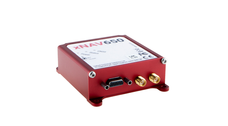
Once the project team realized that they needed an IMU to measure the ship/platform motion, one of their collaborators at the time, Airborne Research Australia (ARA), suggested an OxTS xNAV650.
After they had defined the project requirements, Southern Cross University contacted IMS who helped them navigate the commercial process.
xNAV650 is a miniature INS that uses survey-grade dual-frequency GNSS receivers and custom MEMS IMU for centimeter-level position accuracy, precise orientation and true heading. It logs the navigation data on internal storage for downloading and viewing post-mission. It can be used in many applications, such as corridor mapping and precision agriculture.
The xNAV650’s IMU allowed Southern Cross University to accurately measure the motion of the ship. The IMU was configured to “displace output” to the location of the 3D wind measurement instrument — the sonic anemometer. This allowed the project team to record the movement of the instrument directly, thus avoiding any additional complicated processing steps. Additionally, the IMU was configured to output a 1 pulse per second (PPS) signal via serial connection. This allowed the project team to connect the IMU to the sonic anemometer’s data logger to sync the time between the two instruments. This was vital on such a rapidly moving platform.
Once installed, the xNAV650 device was able to measure ship motion accurately and at high time resolution
(100 Hz), which was complementary to the team’s wind velocity and BVOC measurements. The PPS output option allowed for simultaneous measurement/recording, which would have otherwise needed to be corrected in post-calibration and would likely not have been as accurate.
“We managed to accurately record ship motion for the entire length of our second voyage,” said Liz Deschaseaux, RRAP’s research fellow on BVOC emissions. “The reliability and accuracy of the xNAV650 has had a real impact on our ability to collect meaningful data.”
Felt has introduced Felt 3.0, which includes new features and native database integrations to improve Geographic Information Systems (GIS) capabilities. The goal of Felt 3.0 is to make data more accessible and actionable for stakeholders. It provides modern GIS tools for teams to visualize, analyze and present important insights and map data relevant to their operations.
The company released version 2.0 in November 2023, which introduced UI and spatial analysis tools. This was the first step towards allowing users to gather insights from geospatial data for recruiting, analytics, management and more. Now, with Felt 3.0, teams can connect their database directly to Felt and build interactive components and dashboards tailored to their specific workflow.
Felt 3.0 allows users to directly connect Postgres/PostGIS and Snowflake databases and keep the data fresh with automated live data updates. Support for other third-party data sources, including Databricks, Amazon’s S3 and Redshift, Google’s BigQuery, and SpatioTemporal Asset Catalogs (STAC), will be available soon.
Developers can also use Felt’s new API to reduce engineering time for custom geospatial app implementations. The API allows users to create and style elements and listen to map updates via webhooks, while providing a Python SDK for professionals to continue to work in their preferred tools.