Red Hen Systems offers VMS-HDII Gas Finder, a turnkey pipeline patrol service solution. It detects pipeline gas leaks in parts per million (ppm) while capturing their locations on maps and video. This combination of Red Hens’ VMS-333 hardware and Boreal GasFinderAB laser delivers the information decision-makers need in order to quickly respond to problematic cracks or leaks in pipelines, the company said.
Red Hen Systems President Neil Havermale said the VMS-HDII Gas Finder is easier to use and more cost effective than other pipeline patrol solutions. “Simply put, our process involves gathering customer’s important data, processing their data, and making it available to them whenever and wherever they please.”
Designed specifically for pipeline corridor patrol and field-tested over the course of many years, this robust system helps enable companies to meet FERC compliance, keep patrol costs down and, detect leaks or defects in rugged and inaccessible terrain. Once leak detection data, video data, and mapping data are collected Red Hen Systems provides anytime, anywhere viewing via Google Earth or ESRI ArcGIS. Video images of the locations of detected gas leaks help companies identify the source, while providing a visual reference to integrity maintenance crews deployed to address the problem. With more than 80 percent of methane leaks occurring within pipeline corridors and related surface equipment, reliable detection and location data is vital.
The VMS-HDII Gas Finder offers a reliable means for maintaining the integrity of nearby assets and assuring the safety and wellbeing of populations and the environment. Boreal laser technology, which is used in our pipeline patrol service, was tested at the Rocky Mountain Oil Field Testing Center (RMOTC) where it substantially out-performed other gas leak detection devices tested at the facility, the company said. Data is collected during corridor patrol with a video camera, a GPS unit, and a high-definition video recorder. The VMS-HDII simultaneously records several streams of data as one file to be mapped following the operation. The gas detection map is viewable anytime, anywhere on Google Earth or ESRI ArcGIS through Red Hen Systems’ server.
The map visually indicates where each leak was detected by the Boreal Laser and is paired with the measurement of each leak in parts per million. Red Hen Systems recognizes that not all companies’ needs are the same, allowing the VMS-HDII Gas Finder to be customized to meet individual specifications.
The National Coordination Office for Spaced-Based PNT is the permanent staff of the National Executive Committee for Space-Based Positioning, Navigation, and Timing. It is the central node within the government for GPS-related policy matters.
Brecht-Clark is a Senior Executive Service (SES) official from the Department of Transportation’s (DOT) Research and Innovative Technology Administration (RITA). She is recognized in the areas of research and policy development related to transportation safety and security. She has more than 30 years of experience with federal and state government offices as well as industry firms.
In 2011-2012, Brecht-Clark served for 19 months as the Counselor for Transportation with the U.S. Embassy in Kabul, Afghanistan. Appointed by the Secretary of Transportation, she managed a team of professionals from across DOT, working to assist the government of Afghanistan in developing their governance capacity over transportation assets and responsibilities. Her team assisted the Afghan government in the design and approval of both a civil aviation authority and a railroad authority.
Russo served as the director from January 19, 2010, to December 14, 2012. During that time, he was also an SES official from the DOT’s RITA. Russo also served as deputy director of the National Coordination Office from 2007 to 2009. During that time, he was an active duty Air Force Colonel representing the Department of Defense.
Magellan today announced that it has expanded the worldwide availability of the Magellan Switch Series of crossover GPS watches to Europe for athletes who run, bike, swim or participate in a variety of outdoor activities. The Magellan Switch and Switch Up watches are available this month from select retailers and through Magellan’s European distribution network.
To support its European users, Magellan has also expanded its Magellan Active website with additional languages including French, Spanish, German, Italian and Dutch as well as English. Magellan Active makes it convenient for multisport athletes who record their performance data on Magellan’s Switch Series to easily upload and track data online with intuitive charts, maps and metrics, from a single location, Magellan said.
“Magellan is continuing to further enrich the lives of multi-sport athletes worldwide with best-in-class fitness watches and innovative tools to help them take control of their active lifestyles,” said Clark Weber, Senior Director of Fitness Products for Magellan. “The Switch Series is rapidly gaining popularity with fitness enthusiasts, and we are pleased to work with our European distribution partners to make our GPS watches available to consumers throughout Europe.”
Both Switch watches include features such as an Activity Pacer that shows runners if they are on target with their goal, and provides specific targets to attain the desired result. The Switch GPS watch, designed primarily for runners, includes nine customizable sport profiles, high-resolution display, eight hours of battery life, a high-sensitivity GPS receiver, 50-meter water resistance, and compatibility with ANT+ sensors. The Switch Up GPS watch has the same features as the Switch GPS watch but includes a barometric altimeter for precise elevation data, a thermometer to monitor and capture outside temperature, vibration alerts for notification in louder environments, and a quick-release mounting system to transition between sports.
The Magellan Switch Series is available from Magellan’s European distribution partners serving UK, France, Germany, Turkey, Spain, Italy, Austria, Switzerland and Benelux.
Developer API Program. Magellan also is making available its Magellan Active Developer API program. Third-party websites and applications can now access activity data from Magellan Active and import data into their websites once customer permission has been granted. A Magellan Active Web Widget can be embedded in any website for uploading activities and gives users the ability to upload activities and perform device software updates from within a personal website or HTML Widget/Gadget.
Did you catch the recent announcement on the Hemisphere Precision Products Group sale?
It would appear that the deal has closed, and the Ag and GNSS businesses will be separated and go their own ways. UniStrong Science & Technology Co. in Beijing China has acquired Hemisphere’s precision GNSS business for $15 million. The Ag business will be renamed AgJunction and remain on the Toronto TSX stock exchange with a new ticker symbol, and the GNSS company will in fact become a Canadian subsidiary of UniStrong, with two locations; one in the U.S. and one in Canada. Hemisphere GNSS Inc. will have its business headquarters in Scottsdale, Arizona, and the Canadian operation will remain in Calgary, Alberta.
For those of you who have followed the Ag business, you may recall that Hemisphere had recently bought a company by the name of AgJunction, which focuses on analysis and delivery of real-time prescriptions to in-cab controllers on suitably equipped Ag equipment. So the Ag business will now operate under that name.
As far as the precision GNSS business is concerned, I managed to corner Phil Gabriel, who is the new president of Hemisphere GNSS, and Jon Ladd, who is the new chairman of the board, and ask them about the deal with UniStrong.
The Loka for mobile GIS by UniStrong.
Basically, the old Hemisphere had been challenged with limited resources spread over too many programs, with profitability suffering. So, back almost a year ago a decision was taken to focus on ag and look at options for its non-core (GNSS) business. When Hemisphere appointed Rick Heiniger as its new CEO in September 2012, the board also made the decision to find an appropriate buyer for its Precision Products and Core GNSS Development business. A short list of potential buyers was drawn up and the company’s banker, PI Financial, approached this list of companies seeking a strategic investor. After due consideration, UniStrong turned out to have the best overall offer and made the best strategic fit. Hemisphere chose to negotiate exclusively with UniStrong, and UniStrong formed an acquisition team lead by Jon Ladd (ex-CEO, NovAtel), which also included Werner Gartner (ex-CFO, NovAtel), and due diligence and negotiations got underway.
UniStrong is a major GNSS player in China, established in 1994, headquartered in Beijing with eight branches in China, Hong Kong and Singapore, and more than 1,000 employees. UniStrong’s principle GNSS products appear to be high-end handhelds with GPS/GLONASS/Compass capability for navigation, high-accuracy surveying, GNSS post-processing and systems integration. UniStrong went public in China in 2009/2010 and raised around $75 million in capital.
The Dora handheld with high-precision GNSS, by UniStrong.
The relationship between UniStrong and Hemisphere goes back to 1997 when Phil Gabriel first appointed UniStrong as the Hemisphere distributor in China. Things went well over the years as they mutually expanded their businesses. When they began discussing a potential acquisition, it seemed like a natural progression in the relationship. Xingping Guo, president and CEO of UniStrong, took a significant step forward when he entrusted the acquisition to the team lead by Jon Ladd — this enabled a level of trust to be quickly established and allowed for an accelerated acquisition schedule.
The main issue to overcome seems to have been identifying, defining and clarifying how the new companies would manage themselves in relation to the markets they will go on to serve. This issue was overcome, and several cross-licenses have been put in place which will allow both sides to hopefully operate without future conflict. Clearly AgJunction will be agriculture focused, and Hemisphere will address that segment by supplying GNSS product to AgJunction under a long-term supply agreement.
Mr. Guo has given the new Hemisphere GNSS a wide mandate:
To become a leading global provider of advanced GNSS technology and products across multiple vertical markets, and
To establish Hemisphere as the cornerstone of a global business expansion strategy.
Going forward, Hemisphere GNSS is planning additional investment including the immediate hiring of around a dozen added staff positions. The Calgary location will retain its product development and engineering capabilities, but manufacturing will be transitioned by May to an existing third-party contract manufacturer. Core engineering and product marketing teams in Scottsdale will see growth, and Hemisphere is expected to begin to leverage the strong product engineering and manufacturing capabilities now available through UniStrong. Hemisphere GNSS will focus on OEM GNSS boards and antennas, marine, survey and mapping, and certain machine control applications.
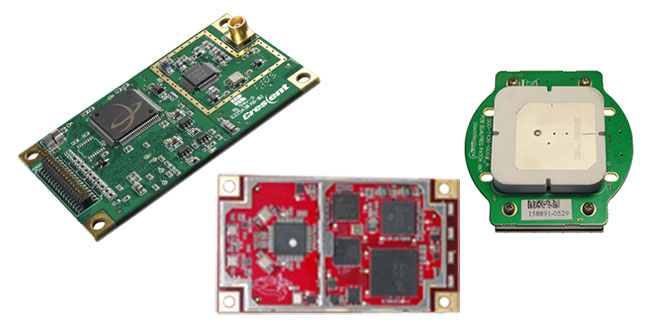
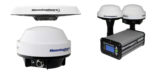
The Vector series compass product line has already enjoyed considerable success with International Marine Organization (IMO) Wheelmark applications for use on large commercial ships, hydrographic surveying vessels, fishing vessels, leisure boats, work boats, and in other general marine navigation applications. Hemisphere will continue to supply Vector as packaged full-function integrated units, also with dual antennas and stand-alone GNSS unit solutions, and in various flavors as OEM components for integrators.
(Clockwise from top left) Vector V103 and V113 GPS Compass, Vector VS330 GNSS Receiver, A325 GNSS Smart Antenna.
OEM components for integrators will continue to include such receivers as the market-leading L1 Crescent module, GPS/GLONASS Eclipse and miniEclipse, Vector enabled receivers, antenna modules, SBX-4 Beacon receiver and the LX-2 L-band receiver.
Survey applications are addressed by the S320 GNSS survey receiver and the XF series data collectors.
Clearly, Hemisphere precision technology will find its way into UniStrong products in China, and COMPASS/Beidou technology will figure largely in Hemisphere’s future. So the transaction will certainly benefit both parties – the basic edict of any acquisition – that the sum of the parts should become greater than they were separately before the acquisition. Good luck to the new international team that is now Hemisphere GNSS!
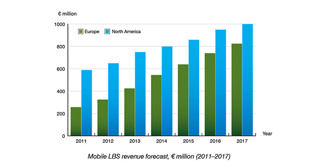
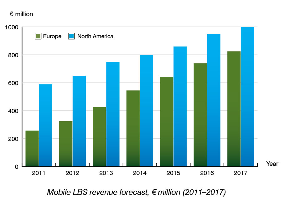
According to a new research report by Berg Insight, mobile location-based service (LBS) revenues in Europe are forecast to grow from €325 million in 2012 at a compound annual growth rate (CAGR) of 20.5 percent to reach €825 million in 2017.
The North American LBS market is forecast to grow at a CAGR of 9.2 percent from US $835 million in 2012 to reach US $1,295 million in 2017. Berg Insight estimates that 40 percent of all mobile subscribers in Europe use some kind of location-enhanced application on a regular basis. In North America, the larger installed base of GPS-enabled handsets and smartphones has enabled higher uptake of LBS.
Berg Insight estimates that about 50 percent of all mobile subscribers in the region now access LBS at least monthly. Local search, social networking and navigation services are the top application categories in terms of number of active users. Mobile workforce management services that aim to improve operational efficiency for businesses are also gaining traction in new industry segments.
“Smartphones are the most important enabler for LBS adoption in general. The installed base of smartphones in Europe has now reached 45 percent of total handsets and already surpassed 55 percent in North America,” said André Malm, Senior Analyst, Berg Insight. He adds that besides differences in smartphone adoption, there are other regional differences. “Mobile operators still play a more central role in North America than in Europe, marketing branded services to both consumer and enterprise customers.”
However, the operators’ central role in the LBS ecosystem is now being challenged by the smartphone ecosystems that bundle key LBS and give developers access to location data and distribution channels in the form of on-device app stores. Mobile operators are therefore showing renewed interest in offering network-based bulk location data for advertising and analytics, as well as new services such as secure authentication and fraud management.
Bryton Incorporated has chosen to integrate u-blox’ UBX-G6010 GPS single chip to give its sports electronics products location-aware features. Founded in 2009, Taiwan-based Bryton has established a brand of GPS-enabled sports monitoring devices dedicated to four main activities: cycling, fitness, outdoor adventure and athletic training.
“At Bryton, we understand the mindset of sport enthusiasts, and know exactly what they are looking for when they shop for electronic equipment to enhance their exercise experience: it must be smart, small, attractive, accurate, dependable, and packed with interesting and useful features that make their workouts more fun and informative,” said Wolf Lin, President at Bryton Inc.
“u-blox’ extremely small GPS chip solution requires very few external components, meaning we don’t need to allocate much space in our products to achieve state-of-the-art, extremely sensitive GPS positioning capability,” added Lin. “Another primary feature is long battery life. Thanks to u-blox’ low power chip design with sophisticated power saving modes, the GPS receiver, which must be active much of the time, requires only a small fraction of the device’s power.”
Bryton evaluated leading vendors of GPS technology and selected u‑blox’ GPS single-chip based on four key product features: small size, high sensitivity, low-power consumption, and upgradability.
Bryton markets its products under two main product categories:
Rider. An extensive line of waterproof bike computers that provide navigation while monitoring location, distance, elevation, route history as well as heart rate and calories usage.
Cardio. Smart sports watches for runners with integrated GPS that delivers accurate time, pace, distance, stride, lap information and much more.
Supergeo has developed an iOS mobile GIS app to promote the local tourism industry in Yilan, Taiwan. Integrating local tourist information and a Google Maps display, the app provides practical travel information for better itinerary planning.
Situated on Lan-Yang plain, Taiwan, Yilan County is famous for its natural beauty, a rich culture and abundant agricultural products. Convenient transportation has encouraged more people to travel to this county for vacations.
Supergeo cooperated with Department of Applied Economics & Management of National Yilan University and Yilan Leisure Farming Development Association to develop the iOS mobile GIS application by means of GIS and mobile technologies.
With an easy-to-use interface, the Yilan Travel Guide App offers detailed tour guides for destinations, a tourism map display and itinerary planning functions. Visitors can easily search and obtain the latest information about popular destinations, restaurants and accommodations in Yilan. The app is composed of four themes: Nearby Tourist Attractions, Specialists Lead the Way, Itinerary Plan and My Favorites.
SuperGIS Server 3.1 has plans to integrate maps, local tourist spots and related travel information and publish various map services via web browsers, making the tourist information more manageable to system administrators and more accessible to regular users.
The widely used ArcGIS for Desktop extensions provide simple access to powerful petroleum workflows. All oil and gas companies on the ArcGIS 10.1 platform can now use Team-GIS software for data transfer, play based exploration, license ranking, reserve estimation and well-pad pattern planning.
The Exprodat Team-GIS software is used by oil and gas teams for petroleum exploration and production workflow, using Esri’s ArcGIS platform. Because the Exprodat Team-GIS software is data independent, oil and gas companies are able to integrate vendor data with their own in-house datasets. This means that, through this enhanced GIS-based spatial analysis, decisions can be made faster, risk can be managed and technical uncertainty is reduced, Team-GIS said.
“Our Team-GIS extensions were designed with the geoscientist in mind,” said Exprodat’s Technical Director Chris Jepps. “You don’t need to be a GIS specialist or understand niche spatial terminology in order to achieve many complex spatial analysis workflows common in oil and gas. We’re delighted that our extensions are now available to organisations working on the ArcGIS 10.1 platform.”
The Team-GIS software suite comprises these extensions:
Acreage Analyst – rank exploration blocks, leases and companies
Directory – find, preview and add spatial data, increase ArcGIS user adoption
KBridge – transfer data between KINGDOM and ArcGIS
Segment Analyst – create play chance maps
Unconventionals Analyst – estimate reserves and optimize well patterns.
People worried about getting caught in an earthquake will be relieved to know there’s an app for that. The iPhone app, Earthquake Buddy, which was recently featured at an IEEE conference, sends a warning email to those in 5.0 and higher earthquakes to alert them of impending danger. If users fail to respond in a given amount of time, someone sends the cavalry.
This app, which could be very handy in some parts of the world, is the result of a combination of technologies, including remote sensors, cloud computing and geographic information systems (GIS).
“The power of GIS technology lies in its ability to combine location-based information with other data to perform complex analyses to gain insights and automate processes in ways never before possible,” said Stephen McElroy, GIS program chair at American Sentinel University. “GIS is used in many phases of disaster management and this starts before an event actually happens.”
McElroy notes that in the immediate aftermath of a serious disaster, such as an earthquake, the most pressing needs facing GIS managers is to estimate the impact of the disaster on the local population where first responders need to focus their rescue efforts.
Technicians and geospatial analysts use GIS technology to collect, store, analyze and share geospatial information needed by agencies to effectively support operations, aid disaster relief and restore disaster-affected areas.
GIS professionals understand how to make the technology work, McElroy said. However, organizations can still see limitations in their abilities to use GIS, particularly in remote offices that might not have the same speedy access to corporate data centers as a headquarters or regional facility.
GIS technicians can add flexibility and options that are unavailable any other way, largely due to the inherent capabilities of cloud computing. These options include:
Centralized resources: Cloud computing can allow a company or its service provider to centrally deploy and manage GIS resources, reducing the cost of management complexity.
Service delivery everywhere: When software is deployed locally, users are dependent on being within the reach of the organization’s data center. With cloud delivery, users can be virtually anywhere that an Internet connection exists.
Leverage of mobile devices: In a traditional GIS implementation, software might run on a server or a desktop. But in either case, users are bound to the office. With a cloud deployment, it’s possible to provide access through any sort of device, including smartphones and tablets, improving the organization’s operational flexibility.
Use of a service provider’s expertise: Having GIS experts on staff doesn’t eliminate the costs and complexities of using the associated software. Companies may need to train IT staff on how to run the applications. With cloud access from a vendor, a company can make use of the capabilities and leave issues of maintenance, configurations, and upgrades to people whose full-time job it is to manage the software in question.
Scaling up or down: When a company runs software on its own premises in traditional configurations, adding users can be complicated. The company might have to order new servers and undertake a system upgrade. With cloud computing, a company that needs to ramp up GIS use simply adds users to the monthly contract and can then scale back down to save money.
“In our technology-hungry world any company that might use GIS internally or for customer applications and cannot afford for the data to be accessible for a long period of time should strongly consider whether a cloud implementation might offer some compelling benefits,” McElroy said.
Next month Spirent is hosting a meeting with hands-on training sessions on GNSS simulation equipment led by Spirent engineers. The 2013 Spirent Federal 2013 GNSS Technical Interchange Meeting will be held March 19-21 at the DoubleTree Hotel Anaheim-Orange County, in Orange, California.
March 19 and 20 are for general participation. The third day, March 21, features FOUO (For Official Use Only) sessions for U.S. citizens only.
The Lockheed Martin team developing the U.S. Air Force’s next generation Global Position System III satellites has completed a key flight software milestone validating the software’s ability to provide reliable and effective command and control for the GPS III satellites planned for launch into orbit.
The GPS III program will affordably replace aging GPS satellites, while improving capability to meet the evolving demands of military, commercial and civilian users. GPS III satellites will deliver better accuracy and improved anti-jamming power while enhancing the spacecraft’s design life and adding a new civil signal designed to be interoperable with international global navigation satellite systems.
The milestone, known as Software Item Qualification Testing (SIQT), was completed for the satellite’s spacecraft bus flight software, which is critical to controlling the spacecraft on orbit and monitoring the health and safety of the satellite’s subsystems. SIQT included 131 individual test events and represented the culmination of a rigorous software engineering risk reduction and development phase. The software will next be integrated and tested on the first GPS III satellite, which is on schedule for launch availability in 2014.
“Completion of this flight software milestone demonstrates our continued positive program momentum and is another step forward in reducing risk up front to facilitate long term affordability,” said Lt. Col. William ‘Todd’ Caldwell, the U.S. Air Force’s GPS III program manager. “In this challenging budget environment, the entire government and industry team is focused on delivering the critical GPS III satellites affordably and efficiently for users worldwide.”
To further reduce risk, the flight software has already been integrated and tested on the program’s satellite prototype, known as the GPS III Non-Flight Satellite Testbed (GNST).
“Delivering fully qualified flight software this early in program development demonstrates the rigor of our GPS III software development processes,” said Keoki Jackson, vice president of Lockheed Martin’s Navigation Systems mission area. “Through up-front investments in high-fidelity, flight equivalent hardware and software testbeds, our team successfully executed on schedule to develop and qualify the flight software critical to the success of the GPS III program.”
Lockheed Martin is on contract to deliver the first four GPS III satellites for launch. The Air Force plans to purchase up to 32 GPS III satellites.
The GPS III team is led by the Global Positioning Systems Directorate at the U.S. Air Force Space and Missile Systems Center. Lockheed Martin is the GPS III prime contractor with teammates ITT Exelis, General Dynamics, Infinity Systems Engineering, Honeywell, ATK and other subcontractors. Air Force Space Command’s 2nd Space Operations Squadron (2SOPS), based at Schriever Air Force Base, Colorado, manages and operates the GPS constellation for both civil and military users.