LOCiMOBILE, Inc., a wholly owned subsidiary of GTX Corp, has launched its first enterprise app for companies looking to effectively track and monitor their workforce in real time. Track My Work Force (“TMWF”) is available for download on iTunes, and based on its early success, is in development for release on the Android platform.
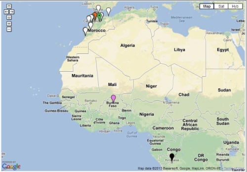
Once downloaded on either an iPhone or iPad, the app works in the background and reports the whereabouts of that device back to the GTX Corp monitoring back-end. The app was designed for small- to medium-sized companies that have a mobile sales or service workforce and need to know the location of their reps in real time. Companies in the U.S., Canada, Czech Republic and Morocco, in industries including transportation, construction, plumbing, IT, medical and pharmaceutical, have already deployed the TMWF app and the GTX back-end monitoring platform.
In January, a pharmaceutical company based out of Morocco that services 25,000 pharmacies across several North African countries deployed TMWF for 150 of its sales reps.
“Our diamond delivery business relies heavily on our traveling sales representatives in order to maintain relations with existing customers as well as meeting new ones. GTX Corp’s Track My Work Force app was extensively tested during our system trial,” Jack Daynes of the Diamond Group said. “The results were such that we implemented the program immediately and haven’t regretted it in the slightest. Both the pricing and the service that we’ve received have exceeded our expectations.”
Companies can easily deploy this technology by leveraging the mass adoption of smartphones and tablets in the workforce, said GTX Corp. In January, a pharmaceutical company based out of Morocco that services 25,000 pharmacies across several North African countries deployed the app for 150 of its sales reps.
“We are very pleased with the initial feedback and potential of this app,” said Patrick Bertagna, GTX Corp CEO. “There are tens of thousands of companies all over the world that can benefit and increase customer service, productivity and security from two-way GPS technology and are now able to implement this technology with a simple download.”
The TMWF app is an efficient and cost-effective way for business owners and managers to keep track of and manage their mobile work force, GTX Corp said. It’s faster and safer than text messaging and allows the worker to focus on the task at hand rather than spending valuable time calling HQ to check in and report, the company said. The app costs $9.99 initially, with an additional monthly monitoring service fee that costs around $5.00 per user per month.
The company provides a free two-week evaluation for any business with more than five employees, and custom solutions along with a licensable white-label platform for larger companies.
The Moscow Times is reporting that the first overseas GLONASS ground station for differential correction and monitoring was launched in Brasilia, Brazil, on Tuesday, citing information from the Russian Federal Space Agency (Roscosmos). The station will become the first correction point in the Western Hemisphere and will significantly improve the accuracy of GLONASS navigation signals, the agency said.
GLONASS stations will also be installed in the United States, according to Pravda.Ru. “GLONASS stations are to be installed in the U.S.. This will improve the accuracy of the system. In general, stations like these are planned to be located in more than 30 countries of the world. Most of the countries that received the offers for the installation of the stations responded positively.
“However, the process is slow because of the need to conclude appropriate intergovernmental agreements. The documents with Brazil were signed in 2012. Agreements with Spain, Indonesia and Australia will be finalized soon,” Pravda.Ru said.
The Brazilian SDCM station is located on the campus of the University of Brasilia.
Trimble has acquired a suite of software solutions from Penmap.com Ltd. of Bradford, United Kingdom. Penmap.com’s solutions include both office and field data collection software specifically designed for the cadastral and surveying markets. The comprehensive software suite enables Trimble to further address local application requirements and customer needs by providing complete customized surveying software solutions for the cadastral market, the company said. Financial terms were not disclosed.
The software solutions include:
Penmap encore: A new solution specifically designed for PDAs and handheld GPS receivers running Windows Mobile operating system. The software’s revolutionary user-friendly interface takes advantage of virtually the entire display screen to maximize map real-estate and is designed for fingertip operation.
Penmap encoreT: A new premium data collection software specifically designed for tablet PCs running Windows 8, 7, Vista or XP operating system. Its user interface shows collected data on the map in real-time. This feature gives users peace of mind that they have collected data correctly before leaving the site, Trimble said.
Penmap Office: An intuitive office platform for Penmap encore software. The office software streamlines the land administration professional’s workflow — from project preparation and importing data to managing large raster and vector background maps collected in the field, Trimble said.
“Penmap.com has built a very close and successful relationship as a customer of Trimble for many years,” said Erik Schütz, managing director for Penmap.com Ltd. “Since Penmap.com was founded, our vision has been to focus on the local requirements of the regional markets we serve and provide those customers with a fine-tuned and easy-to-use solution. The software is an ideal fit within the Trimble portfolio of solutions to address the cadastral market.”
“The acquisition of Penmap.com’s software suite of office and field solutions reinforces Trimble’s continued commitment to the cadastral market, as well as our focus on providing customers with complete solutions that are customized for local market requirements,” said Matt Delano, business area director for Trimble’s Land Administration Solutions. “Penmap.com’s strength lies in its ability to customize surveying software applications for regional markets, providing users the most intuitive work processes for optimal efficiency and productivity, making it a perfect fit for our customers.”
The explosion of an underground nuclear device by North Korea this week disturbed the Earth’s ionosphere. The blast generated infrasonic waves that propagated all the way to the upper atmosphere causing small variations in the density of electrons there.
By analyzing the signals from GPS satellites collected at ground-based monitoring stations in South Korea and Japan, scientists at the California Institute of Technology’s Jet Propulsion Laboratory, Purdue University, and the Korea Advanced Institute of Science and Technology independently confirmed the ionospheric disturbance generated by the North Korean test.
The researchers used the same GPS signals that are used by surveyors for precise positioning. These signals are slightly perturbed as they transit the ionosphere, and by processing the collected data with sophisticated software, the researchers were able to detect the small effect that the explosion-induced atmospheric waves had on the distribution of the ionosphere’s electrons.
The same technique is being used by the researchers and others to study the ionospheric effects from natural hazards such as tsunamis, earthquakes, and volcanic eruptions.
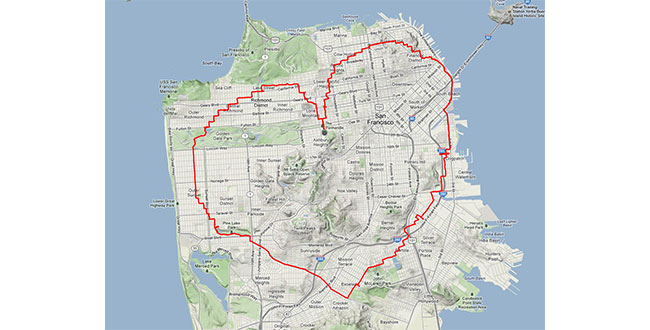
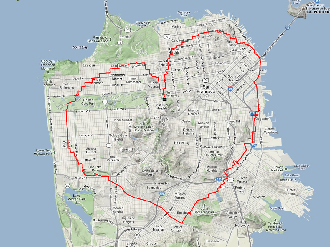
Yes, there is a way. According to Krulwich Wonders, an NPR science blog, a man in San Francisco equipped with an iPhone and tracking app rode his bike 27 miles around the city. Two and a half hours later, Payam Rajabi had etched a heart shape onto a city map.
Click to enlarge.
In 2012, Rajabi had to leave his girlfriend behind in Toronto for a new job. To make sure Clare knew this was a labor of love, Payam included an elevation map of his ups and down in the hilly city.
This year, Verizon is featuring Rajabi — who repeated the feat for cameras — in a television commercial:
There always is a lull in news between the Consumer Electronics Show and the Mobile World Congress, which is later this month in Barcelona. However, published reports that Facebook plans to launch a location application is big news. The social network giant, with more than 1 billion mobile users worldwide, could conceivably generate huge advertising revenue through the location-based friend-finder app. Facebook has a number of competitors, but with the sheer number of worldwide users, it has to make the industry take strong notice.
Facebook to Roll Out Location Application for Mobile Users
Facebook is attempting to grab a big piece of the mobile location market with a new app that will track users to perhaps boost mobile advertising sales. The news, first reported by Bloomberg, indicates that Facebook is adding location features to perhaps take a chunk of profit from 1 billion mobile users who use the social network.
The new feature, expected to be launched in March, will work with smartphones, even when the user is not using the application, according to the Bloomberg article. This may raise some privacy hackles, as competing services have opt-in functions. In addition, some handset manufacturers and carriers require user opt-in as part of privacy agreements.
Facebook already purchased two location companies in Glancee and Gowalla. Glancee is a location-tracking startup Facebook bought in May 2012. Gowalla, a location-based social network, was purchased in December 2011.
Facebook Has Competitors in Location Market
The new Facebook location app will be an answer to Google Latitude, which was launched in early 2009. Latitude, a feature for Google Maps, is an opt-in mobile app that allows users to see the location of friends and family, who also allow the service to track them. Google’s premise, four years ago when it launched Latitude, was that many users wonder where their friends and family are — and what they are doing.
Because it is an opt-in service, Google said users could find out where a spouse was stuck in traffic on the way home from work, knowing when a loved one’s flight landed safely, or if a buddy was in town. Although it has been around for more than four years, Latitude was innovative with the concept that not only can you see friends on a map, but you can get in touch with them via SMS, Google Talk, gmail and updating a status message.
“While Google quietly improved its databases, tools and location services, most other players in the location industry were slipping further behind, apparently involved in a frenzy of disorganization prompted by a lack of skills in strategic planning,” said Mike Dobson, Telemapics president, in a recent interview.
Another similar service, Find My Friends from Apple, runs on the iOS 5 operating system. It is another location share service that attempts to allow users to find friends in real time, according to published reports.
Apple needs to hit a home run in the location and mapping market. Last year, the controversy surrounding Apple Maps caused a shake up at the company and industry because of faulty map data. The incident made manufacturers realize that digital maps are a very important feature for smartphones. It also made many of these giant companies, who believe that location isn’t that big of a deal, sober up to the fact it is hard to make quality maps.
A number of other companies are offering friend and family finder apps, namely Location Labs, Life360 and Loopt.
Still, while such companies as Facebook, Apple and Google give away maps and navigation for free, which destroyed smaller companies and caused a huge consolidation of the industry starting in 2008, some believe that maps are too hard to produce for free. Some analysts, Dobson included, think that “free” maps and navigation services may not stay that way as consumers and enterprise customers demand better accuracy.
Tablet Owners Spend More than Smartphone Buyers
In advance of the Consumer Electronics Show, analysts were saying not only that flatscreen TVs sales were dropping, but the champion of the previous shows, the tablet, also was to see a downward trend. Not so, says ABI Research, which estimates nearly 200 million tablets shipped worldwide since 2009, with an additional 1 billion tablets forecast to ship over the next 5 years.
What’s interesting, or not, depending on your location company’s strategy, is that ABI says 22 percent of users spend $50 or more per month and 9 percent spend $100 or more on purchases ordered from their tablets. That’s higher amounts than from even smartphones, the company says.
As we reported last fall, the next edition of Amazon’s Kindle Fire tablet introduced mapping services in partnership with Nokia, which snubbed technology from Google, which is funny because its mobile operating system powers the platform. But it was an indicator of how much promise companies are still seeing in adding location-based services capability to tablets.
In other LBS news:
Sense Networks released the results of a location-based mobile advertising campaign for Denver-based fast food chain Quiznos. The campaign, conducted in Portland, Oregon, placed ads on mobile devices of people 18-34, who eat at competing, and similar, restaurants such as Subway. The company said Quiznos had a 20 percent gain in coupon redemptions.
TeleCommunication Systems, Inc. (TCS) is providing map, local search, location services and navigation applications for the new BlackBerry 10 smartphone. The TCS-based mapping application will ship with the new smartphones, which are scheduled to roll out in mid-March. TCS’ APIs are also available for Blackberry 10 developers. This leads many in the industry to believe that if this smartphone is a much-needed home run for Research in Motion, the TCS partnership could be a big deal.
Locaid plans to provide GTECH with secure mobile location, IP location and other LBS to include geofencing and location authentication. What’s cool about this deal is GTECH designs and sells lottery technology. Its service includes a geo-complaince engine that ensures a mobile or Internet-connected device is within state lines.
If you have news, or tips, or gossip, please contact me at [email protected]. The Mobile World Congress in Barcelona is coming up this month, so get me your story ideas and product news.
With the introduction of a new version of Pocket 3D software for its HiPer SR GNSS receiver, Topcon Positioning Systems is expanding the delivery of high-accuracy 3D positioning technology to contractors needing a low-cost, one-man layout and measurement system.
Pocket 3D is powerful, easy-to-use data collection and control software for grade checking and other measurement applications on a job site. Version 10.0.2 makes it fully functional with the HiPer SR receiver, introduced in August.
The new receiver is not only “perfect for contractors, but also for other non-traditional GNSS users such as landscape architects, law enforcement forensics projects or any others requiring high-accuracy 3D positioning,” said Tony Vanneman, Topcon construction products marketing manager.
Its field-rugged and fully-integrated design delivers a 1,000-foot working radius through Topcon’s new LongLink technology. “This innovative wireless data link was developed specifically for the HiPer SR, and provides reliable and interference-free base-to-rover communications that don’t require an FCC license to operate,” Vanneman said.
“We took the best signal tracking technologies and packaged them in a small, energy-efficient design,” he said. “Anyone looking for a rugged, easy-to-use, low-cost 3D GPS system will find what they need in the HiPer SR.”
Additional key features of the HiPer SR include:
Shock-resistant magnesium alloy housing – allowing the HiPer SR to take a 6 ft. (2m) pole drop onto concrete;
Arctic sea ice volume has declined by 36 percent in the autumn and 9 percent in the winter between 2003 and 2012, an international team of scientists has discovered.
Researchers used new data from the European Space Agency’s CryoSat-2 satellite spanning 2010 to 2012, and data from NASA’s ICESat satellite from 2003 to 2008 to estimate the volume of sea ice in the Arctic.
They found that from 2003 to 2008, autumn volumes of ice averaged 11,900 cubic kilometers (2,855 cubic miles) But from 2010 to 2012, the average volume had dropped to 7,600 cu. km. (1,823 cu. mi.) a decline of 4,300 cu. km (1,032 cu. mi.) The average ice volume in the winter from 2003 to 2008 was 16,300 cu. km. (3,911 cu. mi.), dropping to 14,800 cu. km (3,551 cu. mi.) between 2010 and 2012 — a difference of 1,500 cu. km. (360 cu. mi.).
A Polar-5 aircraft flying over an Arctic site uses its instruments to validate sea-ice thickness measurements made from space by the Cryosat-2 satellite. (Credit: R. Willatt)
‘The data reveals that thick sea ice has disappeared from a region to the north of Greenland, the Canadian Archipelago, and to the northeast of Svalbard,” said Katharine Giles, a research fellow at the Centre for Polar Observation and Modelling at University College London (UCL) and a member of the scientific team.
Giles and her colleagues report their findings in a paper that has been accepted for publication in Geophysical Research Letters, a journal of the American Geophysical Union. AGU has posted the manuscript online as an accepted article.
The findings confirm the continuing decline in Arctic sea-ice volume simulated by the Pan-Arctic Ice-Ocean Modelling and Assimilation System (PIOMAS), which estimates the volume of Arctic sea ice and had been checked using earlier submarine, mooring, and satellite observations until 2008.
Other satellites have already shown drops in the area covered by Arctic sea ice as the climate has warmed. Indeed, sea-ice extent reached a record minimum in September 2012. But CryoSat-2, launched in April 2010, differs in that it lets scientists estimate the volume of sea ice — a much more accurate indicator of the changes taking place in the Arctic.
“While two years of CryoSat-2 data aren’t indicative of a long-term change, the lower ice thickness and volume in February and March 2012, compared with same period in 2011, may have contributed to the record minimum ice extent during the 2012 autumn,” said Professor Christian Haas of York University, Canada Research Chair for Arctic Sea Ice Geophysics, co-author of the study and coordinator of the international CryoSat sea ice validation activities.
CryoSat-2 measures ice volume using a high-resolution synthetic aperture radar altimeter, which fires pulses of microwave energy down towards the ice. The energy bounces off both the top of sections of ice and the water in the cracks in between. The difference in height between these two surfaces let scientists calculate the volume of the ice cover.
The team confirmed CryoSat-2 estimates of ice volume using measurements from three independent sources — aircraft, moorings, and NASA’s Operation IceBridge.
The research was funded by the Natural Environment Research Council, the European Space Agency, the German Aerospace Center, Alberta Ingenuity, NASA, the Office of Naval Research and the National Science
Foundation.
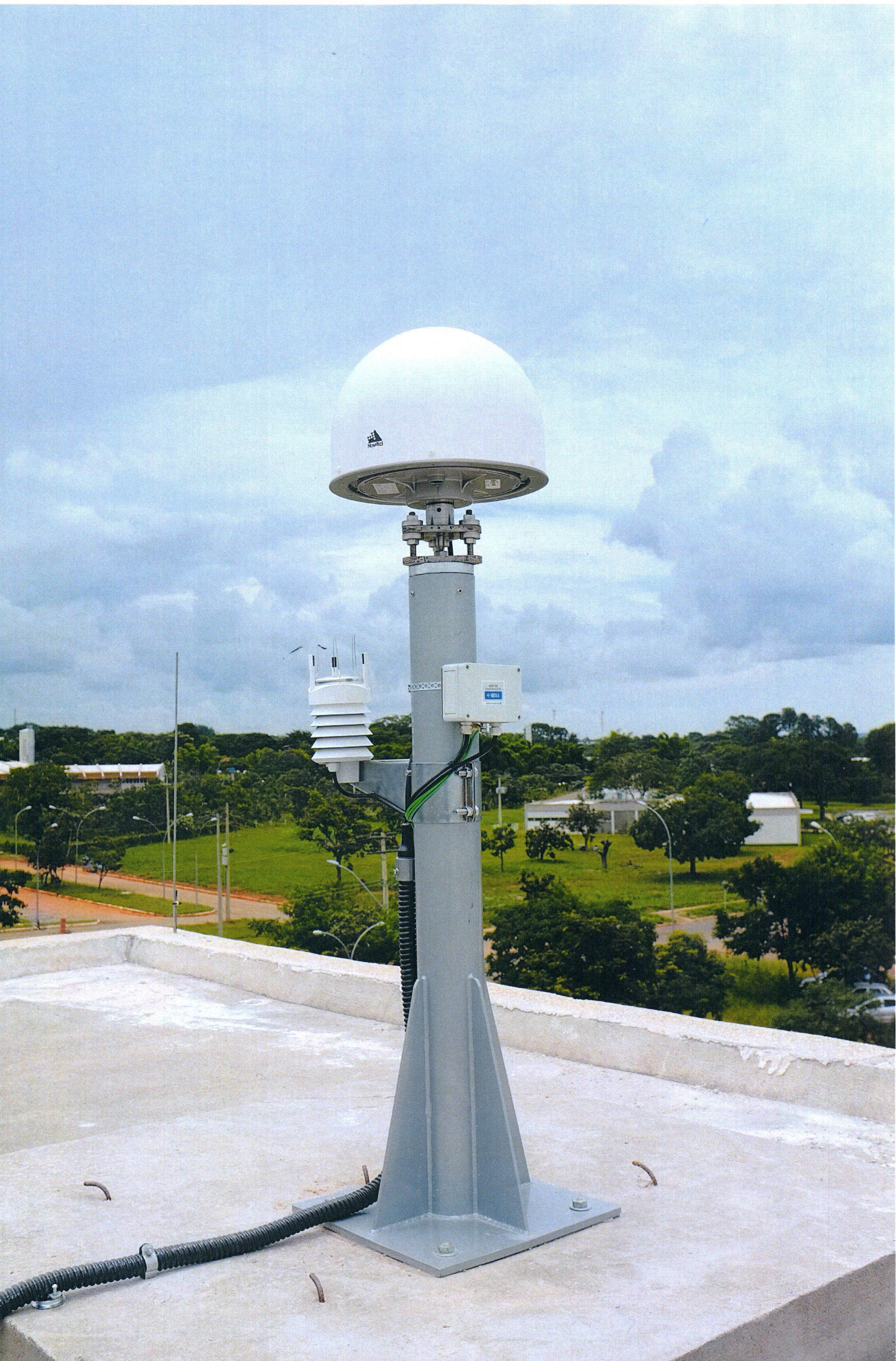
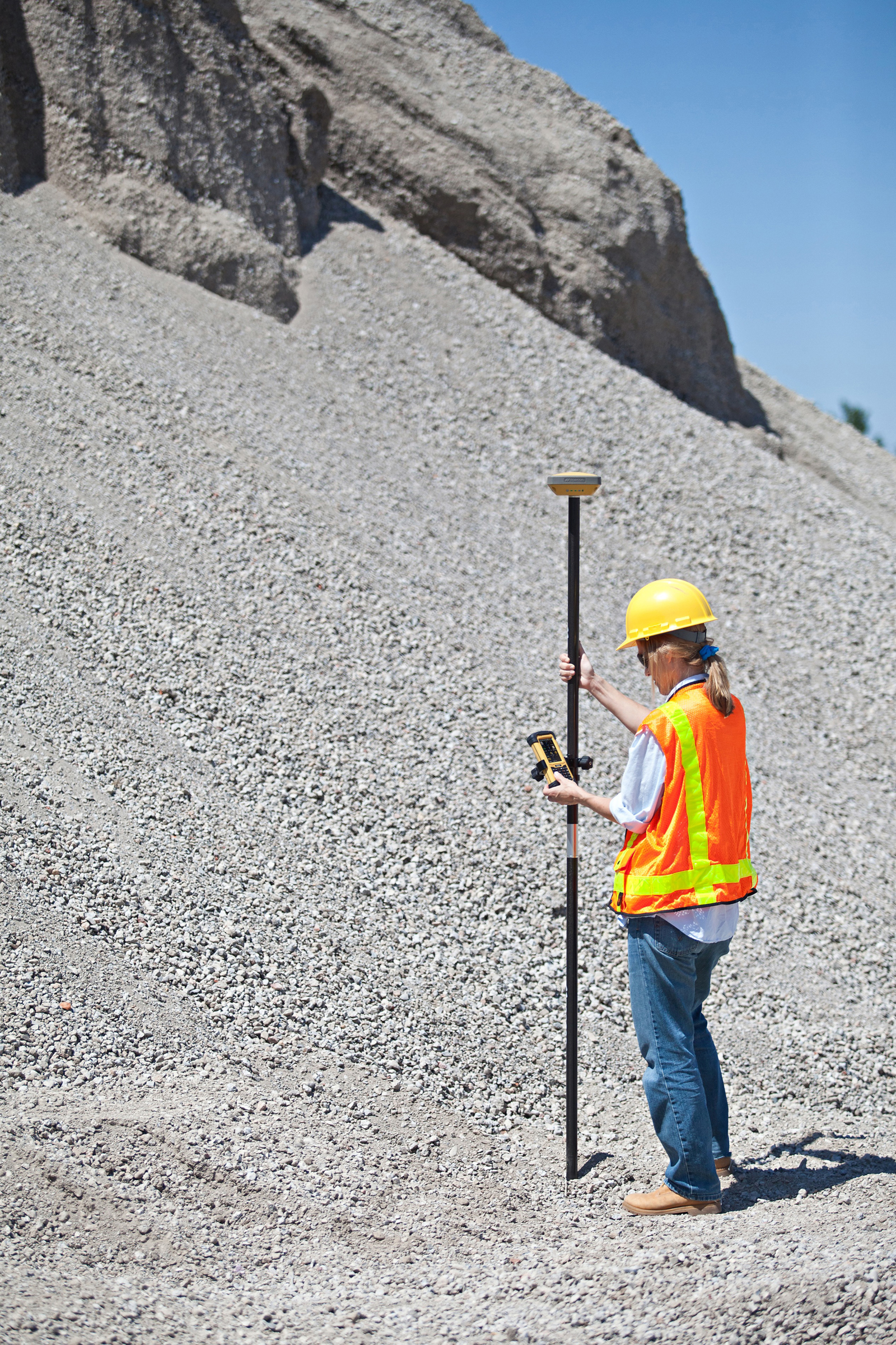
A new system developed by Universidad Carlos III de Madrid (UC3M) researchers uses sensors to improve the ability of GPS to determine a vehicle’s position compared to use of conventional GPS devices by up to 90 percent.
The prototype can guarantee the position of the vehicle to within 1 or 2 meters in urban settings, the researchers said.
Sensor Fusion. The prototype system incorporates a conventional GPS signal with those of other sensors (accelerometers and gyroscopes) to reduce the margin of error in establishing a location. “We have managed to improve the determination of a vehicle’s position in critical cases by between 50 and 90 percent, depending on the degree of the signals’ degradation and the time that is affecting the degradation on the GPS receiver,” said David Martín, a researcher at the Systems Intelligence Laboratory (LSI – Laboratorio de Sistemas Inteligentes) at UC3M. The system was jointly designed and developed by LSI and the Applied Artificial Intelligence Group (GIAA – Grupo de Inteligencia Aplicada Artificial).
The margin of error of a commercial GPS, such as those that are used in cars, is about 15 meters in an open field, where the receiver has wide visibility from the satellites. However, in an urban setting, the determination of a vehicle’s position can be off by more than 50 meters, due to the signals bouncing off of obstacles like buildings, trees, or narrow streets. In certain cases, such as in tunnels, communication is lost, hindering the GPS applications reaching Intelligent Transport Systems, which require a high level of security.
“Future applications that will benefit from the technology that we are currently working on will include cooperative driving, automatic maneuvers for the safety of pedestrians, autonomous vehicles or cooperative collision warning systems,” the scientists comment.
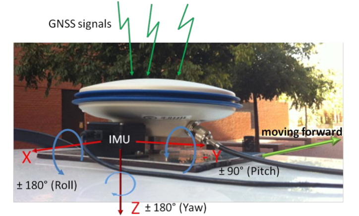
Integration of GNSS antenna of rover receiver and IMU in a platform over the roof of the vehicle.
The greatest problem presented by a commercial GPS in an urban setting is the loss of all satellite signals. “This occurs continually, but commercial receivers partially solve the problem by making use of the urban maps that attempt to position the vehicle in an approximate point,” Martín said. “These devices can indicate to the driver approximately where he is, but they cannot be used as a source of information in an Intelligent Transport System like those we have cited.”
The basic elements that make up this system are a GPS and a low-cost inertial measurement unit (IMU). The latter device integrates three accelerometers and three gyroscopes to measure changes in velocity and maneuvers performed by the vehicle. Then, everything is connected to a computer that has an application that merges the data and corrects the errors in the geographic coordinates. Enrique Martí of UC3M’s GIAA explains, “This software is based on an architecture that uses context information and a powerful algorithm (an unscented Kalman filter) that eliminates the instantaneous deviations caused by the degradation of the signals received by the GPS receiver or the total or partial loss of the satellites.”
The current prototype can be installed in any type of vehicle. It is already working on board the IVVI (Intelligent Vehicle based on Visual Information, pictured above), a car that has become a platform for research and experimentation for professors and students at the university.
The LSI and UC3M researchers working on this “intelligent car” can capture and interpret all of the information available on the road, and that drivers use. To do this, the team is using optical cameras, infrareds and lasers to detect whether drivers are crossing the lines on the road, or whether there are pedestrians in the vehicle’s path, as well as to adapt the speed to the traffic signals and analyze the driver’s level of sleepiness in real time.
Next Steps. The researchers will analyze the possibility of developing a system that makes use of the sensors that are built into smartphones, because intelligent telephones are equipped with more than ten sensors, such as an accelerometer, a gyroscope, a magnetometer, GPS and cameras, in addition to Wi-Fi, Bluetooth or GSM communications.
“We are now starting to work on the integration of this data fusion system into a mobile telephone,” said Enrique Martí, “so that it can integrate all of the measurements that come from its sensors in order to obtain the same result that we have now, but at an even much lower cost, since it is something that almost everyone can carry around in his pocket.”
Blue Marble Geographics has announced the release of Global Energy Mapper 14.1, making available a variety of enhancements in the its GIS tool for energy professionals. This update to the company’s desktop GIS software offers new and improved features and functions, including a significant improvement in the ability to process massive amounts of LiDAR point cloud data, jumping from tens of millions of points to hundreds of millions. B
lue Marble’s geospatial data manipulation, visualization and conversion solutions are used worldwide by thousands of GIS analysts at software, oil and gas, mining, civil engineering, surveying, and technology companies, as well as governmental and university organizations.
Global Energy Mapper 14.1 provides a dramatic increase in LiDAR processing and display speed and the ability to view and process point files in the hundreds of millions range, Blue Marble said. This is beneficial for previewing the data before creating a gridded surface model and includes several options for filtering the data during import and for rendering the point cloud to reflect return type or intensity. Improved metadata access provides a detailed statistical breakdown of the point cloud and customizable point size improves on-screen display. Global Mapper Package (.GMP) files are now able to store LiDAR point clouds in a special compressed format, much smaller than uncompressed LAS data and on par with the best compression available today. This allows LiDAR data to be efficiently archived or shared with other Global Mapper users.
Global Energy Mapper 14.1 also provides a new tool for creating whisker lines emanating from a selected point or points, useful for seismic survey coverage. Whisker lines are often used to estimate coverage from selected points to see if a point in a seismic survey covers what is needed. There is also a new digitizer tool for easily subdividing an existing area into four separate areas that is useful for subdividing parcels or properties.
Version 14.1 includes an enhancement to the Site Pad Placement tool so users can create a site pad for a non-level surface. There are also speed improvements when accessing Spatial On Demand data from our partner Spatial Energy, along with new built in point types for oil and gas symbology, Blue Marble said. Additionally USB dongle licensing is now available for GEM with this release.
“We are excited to be offering this significant upgrade to our Global Energy Mapper customers,” stated Blue Marble President Patrick Cunningham. “We are confident our users in the oil and gas and other energy sectors will be impressed with the improvements in processing LiDAR point clouds along with the new energy specific tools.”
According to tracking data from NORAD/JSpOC, GLONASS 743 experienced a delta-V maneuver on or about February 12 as it approached its new orbital position at Slot 8 in Plane 1.
Note that GLONASS 743 is not currently in service but will likely rejoin the active constellation once the move is completed, replacing GLONASS 701K in the broadcast almanac.
Although GLONASS 701K, the test GLONASS K1 satellite, is currently transmitting on frequency channel -5, it continues to be set unhealthy in the almanac.
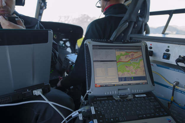
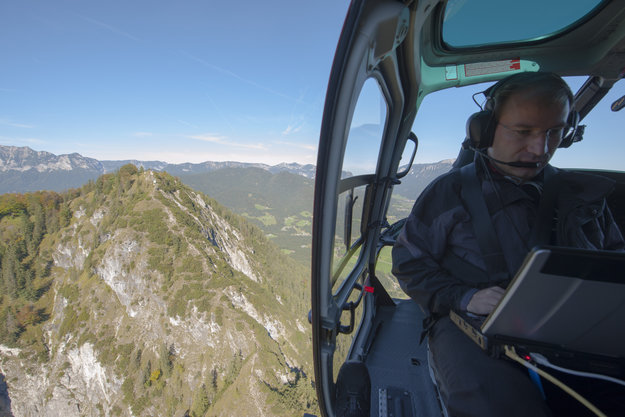
Europe’s two satellite navigation systems could combine in the future for heightened performance, an airborne test has confirmed. A helicopter flight took place above an alpine valley in Germany, the one place on Earth where Galileo services are already routinely available.
The test receiver. The helicopter flew a variety of maneuvers, from fast loops to mid-air hovering, to see how satnav signals were received in practice.
Results of the flight test, conducted in September 2012, show that adding Galileo signals to the European Geostationary Navigation Overlay Service (EGNOS) should boost its accuracy significantly. EGNOS, which augments the accuracy and reliability of GPS signals over Europe, renders satnav usable for safety-critical applications such as aircraft guidance, as well as more general precision uses.
Operational horizontal and vertical distance “protection levels” for safety were cut by half by combining use of GPS and Galileo within EGNOS. In addition, new integrity algorithms installed within the user receiver turned out to reliably detect and exclude reflected or otherwise faulty signals.
The first test of real Galileo navigation fixes is scheduled for later this year from the four satellites already in orbit, with more satellites set to join them by the end of the year.
The Galileo Test and Development Environment – GATE – is a giant outdoor laboratory where prototype Galileo receivers can be used freely without any modifications.
As the constellation takes shape, satnav researchers and industrial developers can already try out Galileo services with prototype receivers at the German Galileo Test and Development Environment, or GATE, a giant outdoor laboratory. GATE, in and around the town of Berchtesgaden in the Bavarian Alps, is Europe’s go-to place for Galileo testing: transmitters atop eight neighbouring mountains cover 65 square kilometers of territory with simulated Galileo signals.
ESA’s Global Navigation Satellite System Evolution program carried out helicopter-based testing here on September 24–26. The results will help to guide the development of next-generation satnav systems.
The helicopter flew a variety of maneuvers, from fast loops to mid-air hovering, to see how satnav signals were received in practice. The test relied on ESA’s SPEED platform — Support Platform for EGNOS Evolutions & Demonstrations, co-funded by French space agency CNES and operated by Thales Alenia Space France — which enabled the receiver to receive simultaneous realtime augmentation for both GPS and Galileo.
Europe’s next-generation EGNOS, planned for around 2020, is envisaged to operate in the same way, with augmentation of both constellations and dual-frequencies at the same time making the system much more robust.
A helicopter flies over the Galileo Test and Development Environment – GATE – in Berchtesgaden, Germany, gathering data on how EGNOS and Galileo will work together. The promising results from the testing are now being analyzed.