Spirent started shipping BeiDou-ready test systems to customers in 2012. The solution will now be upgraded to full-BeiDou capability using the information from the recently released first full issue of the BeiDou-2 Signal-In-Space Interface Control Document (ICD).
“Spirent has successfully demonstrated BeiDou-2 in simulation systems at its offices in Beijing, China,” said Stuart Smith, product manager for Spirent’s positioning and navigation group. “Prior to the ICD release we used recorded navigation data to enable our systems to drive a full BeiDou receiver and qualify the implementation. With the release of ICD information, navigation data is generated automatically, as with the other constellations that the system simulates.”
Spirent’s BeiDou-2 system includes testing for GPS, GLONASS and Galileo, as well as IRNSS, QZSS and SBAS along with options such as interference generation, MEMS sensor simulation and systems targeted at transport segments.
Background on BeiDou. The BeiDou navigation system, sometimes known as Compass, is a project by China that is being deployed in three phases. BeiDou-2 (the second phase) supports regional operation from a network of geostationary, medium earth orbit and inclined orbit satellites. BeiDou-2 adds to the benefits from “Multi-GNSS” where increased accuracy, availability and integrity are possible from using separate, but interoperable GNSS systems.
As with any other GNSS, systems using BeiDou require testing. As well as testing the BeiDou stand-alone operation, Spirent’s systems enable testing of interoperability and co-existence testing with other navigation systems and sensors.
With apologies to the Bard of Avon, as I paraphrase his prose, 2C or not 2C — that is the question for millions of GPS users and has been for several years. Indeed, over the past seven years hardly a week has gone by without an email or inquiry about the status of the GPS L2C signal.
The name “L2C” refers to the radio frequency used by the signal (1227 MHz, or L2) and the fact that it is for civilian use, but of course it will also be used by the military. There are also two military signals on the L2 frequency. In the past couple of months inquiries concerning L2C have become an almost everyday occurrence. Plus I have it on good authority that it was a topic of conversation at recent a PNT EXCOM or Executive Committee Meeting.
However, when I started making inquiries I was met with an interesting dichotomy. One group of users actually laughed and accused me of having a Don Quixote complex and tilting at windmills, since this debate has been continuing for over seven years, while other more sanguine user groups are seriously interested in the future of L2C. Here is what I discovered.
What is L2C?
According to the official U.S. government website concerning GPS, “L2C is the second civilian GPS signal, designed specifically to meet commercial needs. When combined with L1 C/A [ed. coarse acquisition] in a dual-frequency receiver, L2C enables ionospheric correction, a technique that boosts accuracy. Civilians with dual-frequency GPS receivers enjoy the same or better accuracy as the military. For professional users with existing dual-frequency operations, L2C delivers faster signal acquisition, enhanced reliability, and greater operating range. L2C broadcasts at a higher effective power than the legacy L1 C/A signal, making it easier to receive under trees and even indoors. The Commerce Department estimates L2C could generate $5.8 billion in economic productivity benefits through the year 2030. The first GPS IIR(M) satellite featuring L2C launched in 2005. Every GPS satellite fielded since then has included an L2C transmitter.”
Problems
So while this would appear to be a “no brainer” as it were, especially the $5.8 billion in economic benefits, it appears the Global Positioning System is actually at a crossroads and the decision makers are apparently on the horns of a dilemma. For some groups of users, the laudable global PNT (position, navigation and timing) gold standard is looking a bit tarnished of late but has an opportunity to shine once again. The question and future perception of GPS by many global users simply revolves around implementing full navigation messages on signals that are already in place, namely L2 and L5 with CNAV and M-code with MNAV. So, what’s the issue, you say? The signals are there, and in the case of L2C and M-code, have been for seven years — simply upload a full navigation message and be done with all the ambiguity that has become unwelcome baggage for these modern day signals. Au contraire, mon ami, if it were only that simple.
Now grant you this, should be a simple decision, but remember this is the U.S. government we are talking about — apropos failed budgets, endless continuing resolutions, health care fiascos, and the fiscal cliff — important but in the end actually simple decisions all. Unfortunately, history reflects when the U.S. government is involved, nothing is ever easy and timely decisions are hard to come by. So as not to confuse anyone, especially the players, let’s take this process one step at a time and see what all the fuss is about, shall we?
Problem Statement: The L2C and M-code signal capability has been on orbit for more than seven years, since 2005. In 2009, the 2SOPS began uploading and broadcasting a Message Type Zero on L2C, which, while not a navigation message, does put data on the channel. What users are now asking for is the full navigation message on L2C or CNAV, which is a modern-day navigation message and will have significant advantages for all users. Plus, the signal would be available to potentially more than 3 billion users versus the small subset today that utilizes the L2C carrier phase for RTK (real-time kinematic) operations. Indeed, when compared to the L1 C/A (coarse acquisition) signal, L2C has 2.7 dB greater data recovery (with a navigation message) and 0.7 dB greater carrier tracking.
The bottom line is that, with the addition of a valid and updated CNAV message on L2C, all users, the military included, would immediately have ten more potential navigation signals available, and that number would grow with each new GPS launch. Obviously, the same is true for military users with M-code and for all users with an L5 capability. However, the upgrade process needs to start somewhere, and L2C is the obvious choice since there are essentially no M-code receivers available today and there are approximately between 450,000-500,000 L2C capable receivers already in the hands of users.
Assets
Hardware – Simply put, there are currently 10 satellites (SVs) capable of broadcasting a full navigation message or CNAV message on the L2 signal and MNAV message on the M-code signal, also on L2 and three L5 CNAV capable SVs:
7 – IIRM SVs (does not include SVN-49 which, while capable, is currently in residual and/or test status).
3 – IIF SVs (same capabilities as the IIRMs and also capable of broadcasting an L5 signal with CNAV).
While the lack of L2C monitor stations has historically been used as a reason for not broadcasting the new CNAV navigation messages, today there are literally more than one hundred L2C- and L5-capable monitoring stations, which includes the NASA JPL (Jet Propulsion Laboratory) monitoring stations. Logs from several independent monitoring stations show that at any given time there are from one to three L2C SVs visible for the majority of global users, including our warfighters, who in the mountains of Afghanistan need all the signal availability we can provide.
Plus, of the estimated 450,000-500,000 fully capable L2C receivers, several thousand of those are in the hands of our warfighters. Trimble started building in the L2C and L5 CNAV capability as far back as 2003, a full two years before the first L2C launch, for users that wanted the option. However, that option has never been fully tested with live on-air CNAV coded transmissions and they need to be. More on testing later.
From a global user perspective, Japan has essentially leapfrogged the U.S., since the L2C and L5 signals with full CNAV messages are already being broadcast on the Japanese QZSS navigation satellite QZSS-1.
Software was initially thought to be an issue, but according to my sources, the current MNAV or M-code full navigation message is remarkably similar, as to be almost identical to the CNAV messages for L2C and L5, and MNAV has already been shown to work well on the ten GPS SVs capable of broadcasting the M-code signal. Granted, it is not fully integrated into the current OCS or operational control system known as AEP or Architecture Evolution Plan, but then not many future capabilities are, so this is really not an issue since manual processes abound in the current OCS. The L2C, L5 and M-code full navigation messages are supposedly still part of the plan for OCX or the future operational control system for GPS, which should be up and working sometime in early 2017. This would be twelve years after the L2C and M-code signal capability was first placed on orbit.
Timelines
Given those timelines, some would say, hey that’s only four years from now, maybe five if you count testing, and the full navigation message might actually be turned on. But, alas, rumors abound that there is a government agency apparently objecting to the immediate activation of L2C and L5. This agency, and it is not hard to ferret out exactly which one, wants extensive testing to ensure there will be no complications with the WAAS or Wide Area Augmentation System broadcasts, and as an alternative plan it proposes waiting until all the L5 satellites are on orbit before activating navigation messages on L2C or L5. Let’s do the math – that’s 24 L5 SVs, before the L2C and L5 PNT signals are activated with full navigation messages. At one launch per year, the current GPS launch rate, and it matters not whether it is a IIF or a III, and with three L5 SVs already on orbit, that effectively means we will see all 24 L5 SVs on orbit sometime in 2034, if indeed the II-F SVs are truly the first 30-year GPS SVs. If not, then it could be as late as 2037. However, given the average life span of GPS SVs today, it is more than likely that by 2037 every single L2C, L5 and M-code capable satellite on orbit today will have been disposed of without ever having broadcast any of the new signals for which they were designed. Now, how’s that for a lachrymose plan?
Fortunately, this alternate long-term “plan’ has not a prayer of passing, dare I utter the words, the dreaded Washington Post test. Never having purposely written anything for the Washington Post, even though several of my articles have been quoted and misquoted there, it is still a force to be reckoned with in our nation’s capital, simply because the Washington Post continually asks the question, “Is this a wise use of taxpayer’s money?” The answer for the alternative GPS L2C and L5 plan is obvious.
Personnel and monetary issues are always mentioned in the context of new GPS capabilities; however, I have no doubts that the absolutely superb blue suit operators, tacticians and support contractors at 2SOPS are more than capable of performing the simple actions of uploading the new navigation messages on their own.
Sure, times are tough but the blue suit operators and their on-site support staff, at the 2SOPS, have proven themselves time and again to simply be the best in the business. They have brought GPS SVs back from the dead, they (with Braxton Technologies Software) maintain residual satellites that everyone thought for years was an impossible task, and they have saved SVs for important missions that everyone else thought should have been abandoned. We don’t give the fine men and women at Schriever AFB, the 50th Space Wing and the 2SOPS (2nd Space Operations Squadron) enough credit, and I am not about to sell them short. I am convinced the signals in question can be uploaded with full navigation messages, tested and made operational, even if only on a test basis, within six months without expensive outside help.
Full-Scale Testing
This brings us back to the full testing proposal, which actually makes a lot of sense. We (all users) need immediate full scale and extensive operational evaluations that confirm “we have it right” with the CNAV and MNAV data messages. We should encourage manufacturers to participate in this testing process to ensure their GPS devices meet specifications and are not flawed because of a misinterpretation of an interface specification. The GPS equipment manufacturers would be the first to embrace this approach. The manufacturers and users need open-air full-scale testing with valid CNAV messages being broadcast by numerous satellites to ensure they have coded the L2C, L5 and M-code receivers properly.
Immediate testing is the key here, because otherwise under one proposed plan we will only find out if there is a problem with full end-to-end testing of the L2C CNAV signal and user equipment 13 years after manufacturers began fielding the supposed and promised capability. Under the wait for L5 FOC (full operational capability) plan, we won’t find out if the implementation of specifications are correct for another 20-plus years. Personally, I find this to be unacceptable. We need to begin the immediate six-month test plan now.
The aviation community has the mantra, “Test it as you fly it.” We should not do any less. A full six-month evaluation is absolutely appropriate and should be undertaken now. We cannot afford to repeat the 5.5C debacle. [ed. click to read more about 5.5C].
Users, of course, are the prime concern. If you or your organization, including the military, can benefit from 23 more navigation signals today (and three additional signals each year from now until 2034), one of them being the strongest GPS signal to ever be broadcast (L5 with CNAV), and you want/need those signals active now, then please let us know. You may email me at [email protected].
Stand up and Be Heard
Although some of my comments have been a bit tongue-in-cheek, this is indeed your chance to be heard and to make a difference. Let there be no mistake: there is no other PNT system in existence today, planned or unplanned, on the drawing boards or on PowerPoint slides that approaches the capability, availability, reliability, longevity, accuracy and integrity of the Global Positioning System. The folks at Air Force Space Command have been and continue to be admirable stewards. We just need to let them go about their business without undue restrictions.
Dare to Compare
If you want to know exactly how the GPS compares to other PNT systems, consider that the Russian GLONASS (Globalnaya Navigatsionnaya Sputnikovaya Sistema), which came into existence in 1979 only one year after the first GPS launch, has only been Fully Mission Capable (FOC) as a global PNT system for about two years, and that dubious status is literally day-to-day as it teeters on that magic number of 24 available SVs broadcasting multiple PNT signals simultaneously. Contrast that to the GPS, which currently has 32 active SVs with several additional SVs in residual status. Three GPS SVs are nearing, have attained or will soon attain 20 years on orbit. One of our SVs has been on orbit for more than 22 years. GLONASS has serious problems merely attaining an average SV life of less than five years on orbit. Even the vaunted Chinese are experiencing serious technical, longevity and integrity issues with their multiple PNT constellations. It is just not as easy as it sounds. So yes, GPS is the global PNT gold standard, and its stewards must always strive to improve and lead the way. The GPS must continue to grow and innovate or risk being left behind. This is your chance to contribute to that leadership role. Let your opinion be heard.
Until next time Happy New Year, happy navigating, and keep those card, letters and emails coming.
Septentrio announced on January 7 that it has successfully implemented BeiDou support in the company’s high-precision receiver software, taking advantage of the recent official release of BeiDou’s Interface Control Document (ICD) to including the Chinese satellite navigation signals into its position-velocity-time (PVT) solution.
According to the Belgian GNSS receiver manufacturer, its engineers “are currently processing further data sets to finalize the implementation of full BeiDou support. Although the BeiDou constellation is still being deployed, the data analysis already shows promising results.”
The top panel of Figure 1 compares the height from a stand-alone solution of GPS-only with a GPS+GLONASS solution and a third (in light blue) including BeiDou. “The value added by BeiDou is more than what was expected from a constellation that is still being deployed,” according to Septentrio business development manager Laurent Le Thuaut. “Although the solution is not aided by differential corrections, the position shows an increase in accuracy when sufficient BeiDou satellites are included.”
The bottom panel of Figure 1 shows that, even with the current BeiDou constellation (15 satellites total, of which five are geostationary over China, five in full mid-Earth orbit similar to GPS and GLONASS, and five in inclined geosynchronous orbit over Asia), the total number of satellites used over the European region reached 26 for a short moment.
Figure 2 shows the L1 pseudorange residuals for all constellations individually. This comparison highlights the advantage of the GPS constellation, which builds on two decades of real-time orbit prediction. The BeiDou orbits are “quite accurate for a relatively young constellation, but show typical meter-level jumps when ephemerides are updated,” according to Septentrio.
Septentrio says that the new feature will soon become available on selected company platforms. Users of its multi-constellation receivers will then benefit from improvements in urban availability and signal integrity, thanks to the augmented signal coverage.
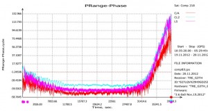
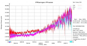
On December 29, two days after the Compass Interface Control Document (ICD) was made publicly available, JAVAD GNSS announced that it had tracked “B3 signal from all launched Compass satellites, using TRE-G3T-E E6-band capable receiver. Graphs shows SNR and ‘code-minus-phase’ combination of GEO svn #5 (sat #215 on graph), IGSO svn #8 (sat #218) and MEO svn #14 (sat #224). ‘C/A’ stands for B1, ‘L5’ for B2, ‘CL2’ for B3.”
The General Lighthouse Authorities of the UK and Ireland (GLA) have announced that ships in the Port of Dover, its approaches and part of the Dover Strait can now use eLoran radio navigation technology as a backup to satnav systems like GPS and Galileo. What is considered the world’s busiest shipping route is the first to deploy eLoran to counter jammers and space weather, the GLA said in a statement.
The ground-based eLoran system provides alternative position and timing signals for improved navigational safety. The Dover area, the world’s busiest shipping lane, is the first in the world to achieve this initial operational capability (IOC) for shipping companies operating both passenger and cargo services.
Today’s announcement represents the first of up to seven eLoran installations to be implemented along the East Coast of the United Kingdom. The Thames Estuary and approaches up to Tilbury, the Humber Estuary and approaches, and the ports of Middlesbrough, Grangemouth and Aberdeen will all benefit from new installations, and the prototype service at Harwich and Felixstowe will be upgraded, the GLA said.
Although primarily intended as a maritime aid to navigation, eLoran could become a cost-effective backup for a wide range of applications that are becoming increasingly reliant on the position and timing information provided by satellite systems.
“Our primary concern at the GLA is for the safety of mariners,” said Captain Ian McNaught, Chief Executive of Trinity House. “But signals from eLoran transmitters could also provide essential backup to telecommunications, smart grid and high frequency trading systems vulnerable to jamming by natural or deliberate means. We encourage ship owners and mariners to assess eLoran in this region and provide feedback to the GLA on its performance.”
P&O Ferries has installed an eLoran receiver on its new vessel Spirit of Britain. She will be based at Dover and is one of the largest passenger ships the busy Dover/Calais route has ever seen.
“Accurate real-time positional information is essential for the safe navigation of ships with modern electronic charts,” Captain Simon Richardson, head of Safety Management at P&O Ferries, said. “Satellite navigation systems are vulnerable to degradation of signal strength and our ships have also experienced occasional loss of signal. We welcome the development of a robust alternative to provide redundancy in real-time positional information and we see eLoran as the most effective solution to countering the problem.”
Commenting on the announcement Stephen Hammond, Minister for Shipping, said, “I congratulate the General Lighthouse Authorities on this initiative that seeks to improve navigational safety in what is the busiest shipping channel in the world, through the development and deployment of technology. I look forward to receiving reports of its effectiveness.”
GPS Plotter makes it easy to plot longitude and latitude coordinates using iPhone, according to app developer Make It Digital. Using the mobile phone’s in-built GPS system, users can plot their current location at the touch of a button. Multiple sessions can be used to create maps plotting anything, and easy export of longitude and latitude coordinates is made possible by utilizing the universal CSV data format.
GPS Plotter is designed for:
Orienteering
Outdoor wayfinding
Tracking unmarked trails
Detailing longitude and latitude on the move
The app is available for 69p ($0.99 US) in the App Store and is compatible with iPhone 4, 4S and 5 running iOS 5 or later.
Researchers at Israel’s Ben-Gurion University of the Negev (BGU) say reveal that data culled from geosocial networks like the GPS traffic app Waze can help prevent traffic incidents with better deployment of police resources at the most accident prone areas.
“Only now are we beginning to discover the potential in the huge amount of data collected daily,” explains BGU researcher and Ph.D. student Michael Fire. “Studies of this kind, which monitor events such as traffic accidents over time, can help the police identify dangerous sections of roads in real time, or alternatively, locations where few police are needed.”
The paper, “Data Mining Opportunities in Geosocial Networks for Improving Road Safety,” was presented at the IEEE 27th Convention of Electrical and Electronics Engineers in Israel.
Waze records location data and enables users to upload and share comments on any detail, including traffic alerts, accidents or police presence. According to its website, Waze has 30 million worldwide users and describes itself as “a community-based traffic and navigation app whose users share real-time traffic and road info, saving time and gas money.”
Using Waze data and Google Earth, the BGU researchers determined that three-quarters (75 percent) of the locations in Israel with the highest number of accidents were intersections. They then analyzed references to a police presence to determine if the police were present at the spots that had the worst traffic accidents.
“There were numerous instances where the police were manning quieter intersections, while busier intersections went unmonitored,” Fire explains. “According to the data, police response time varied from 20 minutes to 40 minutes in some situations.”
Using Waze, data from May and June 2012 was collected and analyzed on accident reports, police presence, traffic jams, and speed traps. BGU researchers identified 579 different locations in Israel that had at least five reoccurring accidents during this time where 5,156 reported accidents occurred. Police were reported at least 15 times at more than 3,500 locations.
Other researchers involved with the study from BGU’s Department of Information Systems Engineering and BGU’s Telekom Innovation Laboratories include Prof. Yuval Elovici, head of the lab, as well as Dr. Rami Puzis, Prof. Lior Rokach as well as student Dima Kagan.
In December 2011, Grizzly Analytics released its first comprehensive report on indoor location positioning technology, predicting that indoor location services were ready to revolutionize the mobile market. The five months that followed have shown how true this was, with new initiatives announced on a regular basis and numerous demonstrations at industry conferences, Grizzly Analytics says.
In a fully revised and updated 163-page report, Grizzly Analytics gives an up-to-date analysis and comprehensive overview of indoor location positioning R&D. Included is information on the research activity of all the major mobile companies — Google, Microsoft, Samsung, Apple, Nokia, RIM, Cisco, Qualcomm, Broadcom, STMicroElectronics, Sony Ericsson and others — and also more than 30 start-up companies that are actively bringing indoor location services to market.
“These technologies are poised to revolutionize smartphone usage by enabling GPS-style mapping, navigation, local search, check-ins, location-sharing and other location-based services to work indoors in malls, megastores, offices, airports, casinos and other big indoor places,” according to a statement by Grizzly Analytics. “Indoor location will also transform commerce, enabling searching for items on store shelves, sending deals and promotions to nearby customers, advertisements for nearby stores in malls, and more. Location services are also entering the enterprise, with indoor asset tracking, employee search, and more.
“In this updated technology trend report, Indoor Location Positioning: Research Pipelines, Start-ups and Predictions, Grizzly Analytics answers the questions you have about this new technology. What approaches are being researched by different companies? Which companies have mature research? What are the gaps in each company’s research that they are likely to fill by acquiring start-up companies? Which start-up companies are likely to be acquired or to emerge successful in the market? What areas of technology are not yet addressed by start-ups, and remain open to new entrepreneurs and investors?”
Advanced Navigation, in collaboration with KVH Industries, has announced its new Spatial FOG GNSS/INS. Spatial FOG is a ruggedized GNSS-aided inertial navigation system and AHRS that provides accurate position, velocity, acceleration and orientation under demanding conditions. It combines the new KVH Industries 1750 fiber-optic gyroscope-based inertial measurement unit with magnetometers, a pressure sensor and a dual-frequency RTK GNSS receiver. These are coupled in a sophisticated fusion algorithm to deliver highly accurate and reliable navigation and orientation, the companies said.
Spatial FOG contains a dual-frequency RTK GNSS receiver that provides 1-centimeter accuracy positioning and supports all of the current and future satellite navigation systems, including GPS, GLONASS, Galileo and Compass.
A next-generation memory backup system allows Spatial FOG to hot start inertial navigation from its last position in 2 seconds and obtain a GNSS fix in as little as 3 seconds. The memory backup system lasts for the lifetime of the product and will provide backup for 24 hours without power.
Spatial FOG’s internal filter runs at 1,000 Hz, and data can also output at this rate over high speed RS232 or RS422. This allows for control of dynamically unstable platforms, the companies said. Spatial FOG is also highly tolerant to both shock and vibration thanks to the performance of the KVH 1750 IMU design and advanced filtering.
Spatial FOG supports a wide range of peripherals including external GNSS receivers, odometers, DVLs, USBLs and NMEA devices. It also supports both industry-standard NMEA output and a binary protocol. Spatial FOG also is easily integrated into retrofits or new designs, said Advanced Navigation.
Telit Wireless Solutions today introduced the UE910 V2 HSDPA (High Speed Downlink Packet Access) and HE910 V2 HSPA+ (High Speed Packet Access) modules based on Qualcomm Technologies, Inc. chipsets, each to be banded for European and North American markets.
The MDM6200-based HE910 V2 supports both GPS and GLONASS location technologies, is fully digital audio capable, and provides full-duplex PCM input and output. With these features — combined with the up to 14.4Mpbs downlink and 5.76Mbps uplink data rates — the HE910 V2 is designed for applications such as video surveillance and security, and emerging applications areas such as healthcare, Smart Home, and Smart Grid.
Both products feature dual-band 3G and GSM/GPRS/EDGE support. The entry-level 3G UE910 V2 is based on Qualcomm Technologies’ QSC6270 chipset and delivers a top 3.6Mbps downlink data rate.
The new products are fully compatible with Telit’s xE910 family and can be easily dropped into existing or planned designs for xE910 modules requiring no additional rework. Positioned at entry-level and mid-range respectively, the new Qualcomm Technologies-based UE910 V2 and HE910 V2 modules enable the Telit xE910 family to enhance cross-technology compatibility with its other popular global air-interface technologies. The application of the Qualcomm Technologies chipsets improves interchangeability between CDMA (1xRTT, EV-DO) and UMTS (HSDPA, HSPA+) variants making the adaptation of customer applications to regional technical requirements quick and easy, minimizing time to market and total cost of ownership.
The QSC6270-based UE910 V2 is to be positioned as a 2G to 3G migration path product, and includes high-value features such as analog audio, making it ideal for applications from home and commercial security and surveillance systems, to asset monitoring, logistics, and mass-transit monitors. Telit is planning a UE910 V2 variant based on QSC6270-Turbo with additional support for Java J2ME 3.2 and eCall.
Both the UE910 V2 and HE910 V2 will be available in local band-group variants as required for all major carriers and partner networks in North America and Europe. The Qualcomm Technologies-based products will be available in North America with 850/1900MHz and in Europe with 900/2100MHz dual-band combinations. Both regional variants will be available in data-only as well as data & voice variants.
“The Qualcomm Technologies-based entry-level 3G UE910 V2 and mid-range HE910 V2 are Telit’s new 3G products launched in response to increasing demand for dual-band HSDPA, and HSPA+ modules,” said Dominikus Hierl, chief marketing officer at Telit Wireless Solutions. “They come to address the need from application areas and regions requiring easy interchangeability between CDMA or UMTS lines of air interface technology, particularly in United States, Europe and key opportunities.”
“Qualcomm Technologies’ fully-integrated QSC6270, QSC6270-Turbo and MDM6200 chipsets support the bandwidth and feature requirements of a broad range of M2M applications, and we are pleased to enable HSDPA, and HSPA+ products in the xE910 family,” said Nakul Duggal, vice president of product management for IOE, Qualcomm Technologies. “By using Qualcomm Technologies’ Gobi 3G solutions in its xE910 product family, Telit will be able to offer its customers the technology flexibility to address M2M products and drive 2G to 3G migration in Europe and North America.”
Trimble’s ThingMagic Mercury6 (M6) RFID Reader will be part of the ng Connect Program’s Connected Service Vehicle, which showcases a full suite of cloud-based services designed to deliver office productivity to vehicle-based workers. In this concept vehicle, the ThingMagic reader will be used to support work-order based inventory management and tool tracking applications to illustrate aspects of a typical service visit.
The ng Connect Program, founded by Alcatel-Lucent, is a multi-industry ecosystem dedicated to the creation of the new generation connected user experience. ng Connect is comprised of more than 190 Contributing and Associate member companies including network, consumer electronics, application and content providers. Twelve proof of concept demos will be featured this year in the Alcatel-Lucent CES booth at the 2013 Consumer Electronics Show, January 8-11, in Las Vegas.
As a collaborating member of the ng Connect program, Trimble is providing the development platform for in-vehicle RFID solutions and sensor technology for high-volume commercial, industrial and enterprise applications. Achievements in the automotive market include receiving the Ford World Excellence Award for contributions to a first-to-market RFID-enabled solution designed to help contractors track and manage their tools.
“We’re honored to join the ecosystem of innovative, market-shaping companies in the ng Connect program,” said Bernd Schoner, vice president of business development at Trimble’s ThingMagic Division. “Using the vehicle as the basic point of data capture can enhance productivity. Uploading asset information from the vehicle to a central data aggregation layer for anywhere, anytime consumption by a variety of applications is the future.”
“Family,” a new app by GPS navigation software company Sygic, is designed to help parents keep their children safe and simplify the way families stay in touch. The app is now live on the Apple App Store and Google Play Store.
The app shows the real-time location of all the family members on the map. It allows parents to set up Safe / Unsafe zones and sends automatic notifications when kids enter or leave a zone. Geofence is useful for one-time notification when users enter certain areas. Augmented reality shows family members in the real surroundings — for example, if kids are running around in a park. Navigation to the family member’s location can be launched from within the app. The app also features free family messaging.
“We wanted to create an app that will help its users in their everyday life,” said Sygic’s CEO Michal Stencl. “As parents we want to raise our children to be self-reliant but we also need to have confidence that they are safe. Family by Sygic gives parents this peace of mind, while kids will appreciate that parents don’t feel the need to call them all the time to check where they are.”
The app is free until January 31st on Google Play and App Store. Afterward, the price will be 2.99 Euro per year/family.