LiveViewGPS, a GPS tracking company for business, government and individuals, is now shipping its VLS 300VZ GPS vehicle tracker that operates exclusively on Verizon’s CDMA wireless system. The hard-wired unit features a three-wire hookup and can be configured to update vehicle locations at 1-, 2- and 5-minute intervals.
The VLS 300VZ GPS vehicle tracker is based on LiveViewGPS’ VLS platform, an Internet-based GPS tracking system for small businesses that need powerful monitoring at a lower price, the company said. It includes a fully-featured, real-time, on-demand GPS tracking system with no software and no contracts required.
Users log on via their web browser or web-enabled mobile device. Once connected, the intuitive, user-friendly interface lets them locate multiple vehicles via a high-resolution satellite map. Users have the option of calling a special phone number instead of using a mobile device. The system automatically texts or emails alerts whenever it detects a vehicle speeding, entering restricted zones, deviating from routes and more. Automated detailed reports include starts/stops, excessive idling, mileage and speeding. State-to-state mileage reporting is also available.
“The VLS 300VZ GPS vehicle tracker is a low-cost entry device for small fleets, company vehicles and personal vehicles in areas with poor GSM coverage,” said George Karonis, LiveViewGPS CEO, “and it’s even programmed to store and forward information whenever a vehicle loses CDMA coverage, so users never have to worry about data loss.”
Today, Hemisphere GPS introduces the Vector VS330 and Vector VS131 GPS compass products that provide high performance heading, position, heave, and attitude data. The new Vector products are designed for professional marine applications such as hydrographic and bathymetric surveys, dredging, oil platform positioning, and buoys that demand a high level of 3D positioning accuracies.
Based on Hemisphere GPS’ Eclipse GNSS technology, Vector VS330 uses the most accurate differential corrections including RTK, L-band, SBAS, and beacon. The smart intelligence from our MFA firmware provides differential solutions by automatically switching to the next best differential source if the original source is no longer available, Hemisphere GPS said.
Vector VS330 is Hemisphere GPS’ flagship receiver and computes heading information with better than 0.01 degrees accuracy when using a 10-meter antenna separation. Positioning accuracy is better than one centimeter in RTK mode or four centimeters when using OmniSTAR HP corrections. Vector VS330 also provides five-centimeter RTK heave and 0.01 degree pitch and roll accuracies.
Combining Hemisphere GPS’ Crescent Vector and LX-2 receivers with two separate antennas, the Vector VS131 computes heading information with better than 0.03 degrees accuracy when using a five-meter antenna separation and better than 50 centimeter position accuracy when using L-band, SBAS, or beacon corrections. Vector VS131 accepts most differential correction signals for unparalleled flexibility to obtain sub-meter positioning in all regions.
The ruggedness of the new Vector enclosure also makes it suitable for more harsh environment installations like machine-control applications, including agriculture, heavy construction equipment, mining equipment, unmanned vehicles, cranes, and other machinery or industries that require very accurate heading and positioning solutions. The Vector’s versatility for providing heading, position, heave, and motion makes it directly compatible with the most popular hydrographic and side scan survey packages. Vector VS330 and VS131 include an intuitive and easy-to-follow user interface to facilitate fast installations.
“Vector VS330 and Vector VS131 are premium additions to Hemisphere GPS’ Vector series product line,” said Phil Gabriel, vice president and general manager, Precision Products, for Hemisphere GPS. “As the demand for more rugged and precise GPS equipment increases, we are meeting this demand by exceeding the accuracy of competitors’ products while being significantly more affordable.”
Vector VS330 and Vector VS131 will be featured by Hemisphere GPS in hall 9, stand B.62 at the INTERGEO Conference and Trade Fair in Hanover, Germany, from October 9-11. Both products will be available for shipping in November through the Hemisphere GPS Precision Products global dealer network.
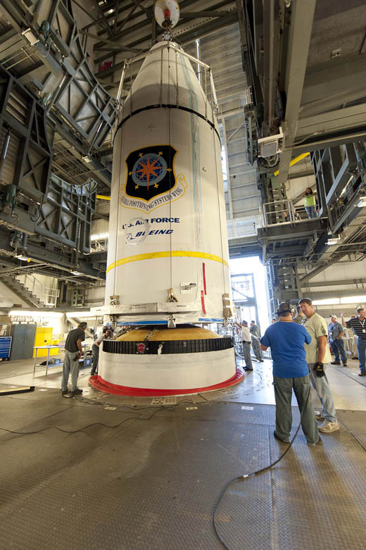
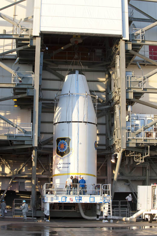
ITT Exelis has passed a major milestone for the U.S. Air Force’s Global Positioning System III (GPS III) program. The company has successfully completed acceptance testing of the navigation payload element for the GPS III Non-Flight Satellite Testbed (GNST), and shipped the pathfinder unit to prime contractor Lockheed Martin’s facility near Denver, Colo., for thermal vacuum testing and space vehicle integration.
In March 2012, Exelis announced that it had been awarded a $32 million contract by Lockheed Martin to build the navigation payloads for GPS III space vehicles three and four.
“The completion of this program milestone is testimony to the fact that we are focused on delivering GPS III capabilities to meet the needs of more than 1 billion users worldwide,” said Mark Pisani, vice president and general manager, Precision Instruments and Positioning, Navigation and Timing Systems, ITT Exelis Geospatial Systems. “We are excited for the next step in this program—delivering the Exelis navigation panel to Lockheed Martin for integration into the space vehicle.”
Affordably replacing and improving the current GPS satellites, GPS III will deliver better accuracy and improved anti-jamming power while enhancing the spacecraft’s design life and adding a new civil signal designed to be interoperable with international global navigation satellite systems.
“Completion of the GNST Navigation Panel Element is a very important milestone for this program,” said Keoki Jackson, vice president of Lockheed Martin’s Navigation Systems mission area. “This accomplishment was made possible by the tremendous teamwork between ITT Exelis, Lockheed Martin, the Aerospace Corporation and the U.S. Air Force. We look forward to integrating the panel onto our pathfinder vehicle and continuing to reduce risk early in the program, paving the way for very efficient and affordable satellite production.”
For nearly 40 years, Exelis payloads and payload components have been on board every GPS satellite and have accumulated more than 500 years of on-orbit life without a single mission-related failure due to Exelis equipment.
The GPS III team is led by the Global Positioning Systems Directorate at the U.S. Air Force Space and Missile Systems Center. Lockheed Martin is the GPS III prime contractor with teammates ITT Exelis, General Dynamics, Infinity Systems Engineering, Honeywell, ATK and other subcontractors. Air Force
Space Command’s 2nd Space Operations Squadron (2SOPS), based at Schriever Air Force Base, Colorado, manages and operates the GPS constellation for both civil and military users.
Trimble introduced today the Trimble Geo 5 and Juno 5 handheld GNSS devices, further extending Trimble’s portfolio for data collection, maintenance and inspection applications. The Geo 5 and Juno 5 series are both optimized for GIS field workflows, including Trimble’s TerraSync field software available on all Trimble GIS platforms.
Since 1994, the Trimble GeoExplorer line of GNSS handhelds has been used for professional GIS data-collection applications. While the GeoExplorer 6000 series is the most capable Trimble handheld for GIS data collection, not all customers require the larger screen and innovative Floodlight technology of the 6000 series. The Geo 5 provides the essential functions for all day, submeter productivity in a smaller package, Trimble said.
The Trimble Juno product line is used worldwide for maintenance, inspections and asset management applications. With the addition of the Juno 5 series, Trimble is providing a rugged handheld that delivers the capabilities and convenience of a smartphone, Trimble said. The Juno 5’s slim, ergonomic design is thinner and lighter than other rugged computing products in its class today and provides a more advanced feature set than the Juno 3 series.
“Whether users are engaged in initial data-collection tasks or inspection of assets, it is critical they have a complete solution they trust,” said Daniel Wallace, general manager of Trimble’s GIS Data Collection Division. “Now with two platforms in both the Geo and Juno families, customers can confidently choose a handheld that best fits their needs. Trimble TerraSync software is the unifying workflow that brings these choices together, so customers can always trust the quality of their data throughout the complete lifecycle of a field management project.”
Complete with wireless communications options, integrated cameras and bright, sunlight-readable screens, both devices are built for work in the field and rugged enough to withstand shock, vibration, water and dust.
JAVAD GNSS has commented on some news that its receivers can track a new L5 signal from the Indian SBAS satellite, GSAT-8, launched on May 20. In a further explanation to GPS World, CEO Javad Ashjaee explained, “All owners of our products can track it. The only thing is that if customers have not updated their firmware for a long time, they should update to recent firmwares released earlier. They need to update their firmware, which is free of charge and is posted on our website. All of our customers with recent firmware versions can track the GAGAN L5 signal.”
An earlier report from CANSPACE that appeared on the GPS World website said, in part, “Although GSAT-8 reportedly carries a dual-frequency transponder, no L5 signals from this satellite have yet been detected by International GNSS Service tracking stations.”
The JAVAD GNSS statement on September 30 said “Report of GPS World that GAGAN PRN127 does not transmit L5 signal is not correct. Our receivers track it. This graph shows code-phase measurements for this signal.” The web page displays this figure:
A check with a University of Bern, Switzerland, report of stations participating in the IGS M-GEX campaign on October 2 found that a number of stations are tracking the L1 signal from GSAT-8 but none are tracking the L5 signal yet due to issues with receiver firmware. However, various stations in the Cooperative Network for GNSS Observation (formerly the Cooperative Network for GIOVE Observation, still abbreviated CONGO), using Javad Triumph receivers, have tracked GAGAN L1 and L5 signals for more than half a year. No detailed analysis of these measurements has been performed so far.
UPDATE: The SVN65/PRN24 L5 transmitter has now been switched on. L5 is the civilian safety-of-life GPS signal, designed to meet demanding requirements for safety-of-life transportation and other high-performance applications.
UPDATE: The GPS Block IIF-3 satellite, SVN65, began transmitting L1 and L2 signals as PRN24 on October 8. A number of stations of the International GNSS Service are now tracking the satellite. The satellite is included in broadcast almanacs although it is set unhealthy and will continue to be so until satellite commissioning is completed. The satellite is still drifting towards its designated orbital position of Slot 1 in Plane A.
Meanwhile, SVN27/PRN27 was decommissioned from active service on October 6 and removed from the broadcast almanacs. However, the L-band
transmitters of SVN27 remain active, presumably for end-of-life testing.
UPDATE: According to Boeing, the satellite manufacturer, SVN65 is on orbit and performing as expected. A Boeing press release stated that “Controllers confirmed initial contact with the spacecraft at 11:43 a.m. Eastern time. The satellite’s GPS signals will be turned on and tested within a few days.”
Incidentally, the launch occurred exactly 55 years to the day after the launch of the world’s first satellite, Sputnik I, on October 4, 1957. It was Doppler tracking of that satellite that gave rise to the Transit navigation system and subsequently, its successor, GPS.
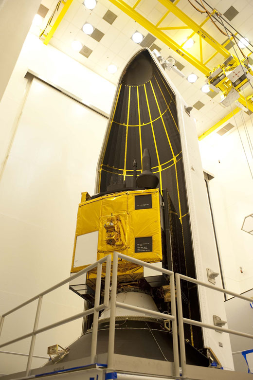
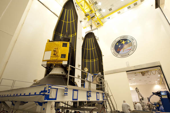
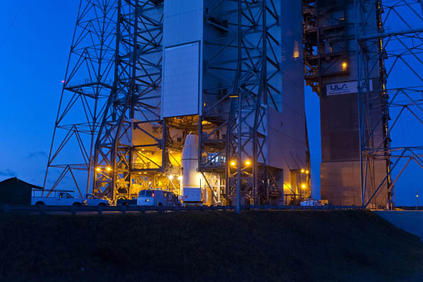
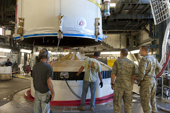
The launch of the GPS Block IIF-3 satellite took place as scheduled October 4 at 12:10 UTC (8:10 a.m. EDT), aboard a United Launch Alliance Delta IV rocket from Cape Canaveral, Florida. Spacecraft separation was reported at 16:27 UTC.
The Boeing-built spacecraft is designed to improve network coverage for both civilian and military networks, including a new L5 signal for improved commercial and civil aviation users.
The satellite, also known as SVN65, will be positioned in orbital slot 1, which is in plane A and will use the PRN24 ranging codes. Slot 1 was recently occupied by a Block IIA satellite, SVN39, operating as PRN09. SVN39 is one of the oldest operating satellites in the GPS fleet, having been launched on 26 June 1993. SVN39 underwent an initital Delta-V on September 27 to move it close to SVN38/PRN08 in slot 3 in plane A, making room for the new Block IIF satellite.
“Congratulations to the entire team on today’s successful launch of the GPS 2F-3 satellite,” Jim Sponnick, ULA vice president, Mission Operations, said in a post-launch press release.
“ULA and our mission partners have a rich heritage with the GPS program and we are proud to have served alongside the government and contractor teams over the last two decades to provide important Global Positioning System capabilities for our national defense and for millions of civilian and commercial users around the world.”
A Delta IV rocket lifts-off with an advanced GPS satellite from Cape Canaveral on Thursday. (Credit: ULA/Atkeison).
2. GPS SATELLITE SVN65 (PRN24) WAS LAUNCHED ON JDAY 278.
A USABINIT NANU WILL BE SENT WHEN THE SATELLITE IS SET ACTIVE TO
SERVICE.
3. POC: CIVILIAN – NAVCEN AT 703-313-5900, HTTP://WWW.NAVCEN.USCG.GOV
MILITARY – GPS OPERATIONS CENTER AT HTTPS://gps.afspc.af.mil/
GPSOC , DSN 560-2541,
COMM 719-567-2541, [email protected] , HTTP://gps.afspc.af.mil/GPSOC/GPS
MILITARY ALTERNATE – JOINT SPACE OPERATIONS CENTER, DSN 276-3514.
COMM 805-606-3514. [email protected]
Geodetics is a small, responsive company that the U.S. Department of Defense (DoD) has gone to for innovative, commercial GNSS solutions. With the growth in the unmanned aircraft vehicle (UAV) market, Geodetics is well positioned with an inventory of novel approaches for applications both on land and in the air. Recently teamed with ITT Exelis, a new Geodetics RTK SAASM product is also well positioned to take off.
I met Geodetics’ President and CEO Lydia Bock at the Geodetics booth at AUVSI in August, and we talked at length about the diverse program, customer and product mix that makes up Geodetics’ business base. The company appears to have benefited by being small, nimble and reactive to a slew of U.S. Forces requirements, which they were able to satisfy, presumably at the expense of several big defense contractors who were unable to spin on a dime the way that Geodetics is able to. And as a consequence, Geodetics has received several recent awards for being among the fastest growing GNSS outfits in North America.
Their small size belies their capability with a significant proportion of the people who work there having doctorates, masters and engineering degrees, but with a really pragmatic and practical way of solving complex problems for DoD.
Founded in 1999, their first objective was to commercialize reference network management development, which they were able to do quite nicely for example the City of Long Beach installed their monitoring systems to detect oil-field subsidence.Water is pumped into the field to extract the oil and as time goes on, the ground sinks around the wells.
By 2003, DoD was looking for commercial innovation and was turning to commercial companies like Geodetics for GNSS solutions. Geodetics was quick to establish a reputation as a problem solver and they began to win more competitive procurements, sometime teamed with some of those big-gun companies who needed to tap their small company innovation.
Over the years, Geodetics has developed capability in cm level relative and absolute real-time positioning and navigation for high and low-dynamic platforms, both manned and unmanned. Solutions not only using GNSS but sensor fusion with Kalman filtering using IMU, step-sensors, magnetometers, barometers and others – including time sync, integrity monitoring, and data smoothing. And of course they have kept on developing the early network capability which got them going, into large scale (>1000 platforms) networks, some of which are RTK based. Geodetics doesn’t regularly talk about to its break-through Epoch-by-Epoch technology which uses a single epoch of data to get to cm level performance — nowadays its just called ‘RTK’.
Army Test & Evaluation and Training has turned out to be one of Geodetics’ main markets, with soldier carried units used for large training exercises. Small, non-intrusive units with 12-15 hours battery capability, data recording/storage, all connected by networked radio through a range radio infrastructure, has allowed the Army to develop new training capabilities.
And where does Lydia think Geodetics will focus next? Their Geo-RelNAV product is designed for relative navigation between airborne platforms and is ideal for maintaining formation flight capability, especially for the growing UAV market. High precision relative navigation is key for UAV collision avoidance and automated landing – wherever precise relative position and orientation is essential between the UAV and other platforms, moving or stationary.
Geodetics uses a number of different commercial and military SAASM receivers in its products, and has recently teamed up with ITT Exelis to develop and introduce a SAASM RTK product. Incorporating proven RTK technology from Geodetics, integrated with the high precision and GPS security features of the EGR-2500 ITT SAASM receiver, this package has several advanced features going for it. Able to run a self-contained RTK on the capable processor of the 2500 receiver, this solution is low power while still being compatible with a number of Geodetics’ nav products including inertial, relative navigation, GPS-based attitude determination, GPS reference network/survey and post-processing tools.
When integrated with inertial, aiding feedback to the ERG 2500 assists the ITT tracking loops to maintain phase lock through 6g turns and get to cm level RTK performance. This Geodetics’ RTK solution on ITT’s Type II SAASM receiver provides customers with a low-power anti-spoofing solution — which must be attractive for the growing UAV market.
ITT is working on its next-generation 2550 receiver which could well show up in Geodetics’ products in the future. The 2550 has an acquisition bank of 2000 correlators for super-fast firstfix and re-acquisition, and they hope to get down to ¾-watt power, which is remarkable for a SAASM receiver. The new RF has even better anti-jam performance and is also M-code ready.
So with a product line-up which also includes reference receivers, data-links, commercial personal navigators, attitude determination packages, precision heading receivers, high-dynamic solutions, and a great track-record in electronics miniaturization, Geodetics is ready for the challenges that the GNSS market will throw at them and still allow them to move forward into the future.
At the magazine’s annual Leadership Dinner, held during the ION-GNSS Conference, we gave the first GNSS Leadership Awards to four individuals for their respective work in the four fields of satellites, signals, services, and products. We asked each recipient to give us a vision of the future: upcoming work, whether that’s something they plan to undertake or they think someone else should get going on, new directions for the industry, and so on. I asked them to ruminate as speculatively and as far into the future as they wished to go. Here’s what they told us.
These are not lifetime or career achievement awards, but recognition of significant contribution in the last year or two. Think of them as the Oscars, the Academy Awards of GNSS, if you will, for significant recent achievement.
Several people were nominated in each category by a small group, then voted on by a larger group of about 40, including the magazine’s Editorial Advisory Board, the contributing editors, and a dozen industry executives.
Here are the award recipients, followed by their remarks to an audience of 200 GNSS international VIPs attending the GPS World dinner.
In the Satellitescategory: Martin Unwin and the Surrey Satellite Technology Team
Principal engineer, SSTL.
For work on the GIOVE-A and Galileo IOV satellites, and on space-borne receivers
In the Signalscategory: Todd Humphreys
Director, Radionavigation Laboratory, and assistant professor, University of Texas at Austin.
Leader of several seminal studies on spoofing and jamming; testified this summer before Congress on the subject.
In the Servicescategory: Waldemar Kunysz
Senior staff engineer, NextNav LLC.
Forwork on Wide Area Positioning System (WAPS) design and implementation in the continental United States.
In the Products category: Robert Lutwak
Chief scientist, Symmetricom.
For practical advances to overcome the intrinsic physical barriers to affordable chip-scale atomic clocks, enabling precision time and time transfer in mobile GNSS and communications systems.
Now, their remarks.
Martin Unwin, honoree in the Satellites category.
Martin Unwin
Principal Engineer, Surrey Satellite Technology Team
“I feel privileged and honoured to receive this award from GPS World.
“With respect to the achievements in GIOVE-A and Galileo, I cannot claim this award on behalf of myself, but I will claim it on behalf of the people in SSTL who made the projects possible, and to those in the team here who have been working tirelessly to make the payloads and satellites happen. We are of course partnered with others in Europe that have been labouring equally hard, so it has been a true team effort.
“With respect to the spaceborne GPS and GNSS activities, my achievements have only been possible thanks to the top class staff we have in the receivers team, and thanks are also due to the support we have had from the rest of SSTL.
“In the 20 years I have been in the company, Surrey Satellite Technology Ltd has grown from a small University-based department to a major player in the international space scene, and I am immensely proud to have been part of this story.
“A few words for the future:
“Whilst it cannot quite match the early heady days of GPS, I still think nevertheless we are entering an exciting time in the GNSS world. We have two operational systems, and within a few years, we will be seeing two more reaching operational capability. Dual-, even triple-frequency civil signals will soon become operationally available, and some very wide bandwidth signals will be sent down, in particular, by Galileo. There is bound to be a steep learning curve in understanding how to exploit these new signals, with a few crevasses to be negotiated during the climb. But these new signals are bound to lead to an expanded vista of increased accuracy and robustness, and undoubtedly some unexpected destinations.
“Taking perhaps the highest perspective, spaceborne remote sensing is a good example that has surprising relevance to the rest of us still on the ground. In this case, GNSS satellites are used as radar sources, and all that is required on a low Earth orbiting satellite to change the world is a GNSS receiver. GPS Radio-Occultation measurements from low Earth orbit are now already the third most important data source for our global weather forecasts, thanks to the like of the COSMIC and MetOp satellites. Furthermore a new constellation of satellites called CYGNSS has recently announced by NASA that will be using ocean-reflected GPS signals to probe inside hurricanes and typhoons, and for the first time will enable the sensing of the wide-scale ocean roughness, leading to improved global wind and wave knowledge.
“By adding to this spaceborne receiver the ability to accommodate signals from Glonass, Galileo and Compass, plus any other available GNSS-type signals, the number of measurements is instantly quadrupled, and a new capability in sensing the atmosphere, waves and even ice and land is likely to be seen. Meteorologists already view GPS as an emerging utility for weather and climate sensing, but I think this new role for GNSS will be reinforced and expanded into yet another area where GNSS incontrovertibly, if indirectly, makes such a significant difference to our daily lives.
“As with many other applications where GNSS has become important or even critical to our modern world, this is, at the same time, both a blessing and a matter for some caution.”
Todd Humphreys, honoree in the Signals category. (credit: Mark Cowart)
Todd Humphreys Director, Radionavigation Laboratory,
and Assistant Professor, University of Texas at Austin
“It’s a genuine honor to receive this award. I’d like to thank Alan Cameron and all the contributors to GPS World. GPS World plays an essential role in building our GNSS community and keeping it together, providing GNSS news, instruction, and, indispensably, gossip!
“I’d also like to thank my students at the University of Texas Radionavigation Lab. Much of the credit for this award goes to them
“The futurist Ray Kurzweil spoke at a conference I attended back in 2001. Maybe some of you have heard of Ray. He’s regarded variously as a prophet, or a crackpot. He’s taking hundreds of vitamins every day to keep himself alive until the singularity arrives, at which point he’ll download himself onto a robot and live forever, or at least he’ll have his head cryogenically frozen so that he can be downloaded and live forever later on.
“In that 2001 talk Ray made some bold predictions. One, in particular, I remember well. “Within the decade,” Ray assured us, “we’ll all be wearing special contact lenses that give us a permanent Internet feed directly to our eyeballs.” Nonsense, I thought, and indeed it was nonsense. Here we are in 2012 and no such contact lenses exist, never mind their being in widespread use.
“I resolved back then that if I were ever called on to peer into the future and tell what I see, as Alan has asked me to do tonight, I’d be more modest about it.
“So tonight I’m going to make a modest prediction, and only one of them. I predict that by the GPS World dinner in 2020 carrier-phase differential GNSS, or, if you prefer an adjective for what should be a noun, Real-Time Kinematic, will be cheap and pervasive. We’ll have it on our cell phones and our tablets. There will be app families devoted to decimeter- and centimeter-level accuracy. The consequences will be fantastic. And this will be enormously disruptive to the current precision navigation industry. This will be the commoditization of centimeter-level GNSS.
“Now you may very well object to this prediction. You might point out that integer ambiguities will be difficult to resolve in the face of the near-field effects around and poor placement of the GNSS antenna in handheld units. You might also argue that the increased power requirements of carrier-phase techniques will be a dealbreaker for mobile devices. That’s all fine. I agree that those are hard problems. My students and I are looking into them, trying to overcome them.
“But please don’t make as one of your objections the one that I’ve heard so many times: “Why would anyone ever want cm-accurate positioning in their cell phone?” Because I’ll object that your objection lacks imagination.
“To see one example of what could be done with commoditized centimeter-accurate GNSS, I invite you all to a presentation by my students Daniel Shepard, Ken Pesyna, and Jahshan Bhatti tomorrow in the F5 Session (Millimeter-accurate Augmented Reality Enabled by Carrier-Phase Differential GPS). They’ll show off a crude box that we’ve built, through which, if you peer, you can see a sandcastle that’s not really there. And you can walk around the sandcastle and see it from all sides with centimeter accuracy.
“Imagine when this technology is in our tablets! Or, better yet, when it’s in our glasses — or, I suppose, our contact lenses. Not that I’m making any predictions about contact lenses…”
Waldemar Kunysz, honoree in the Services category. (credit: Mark Cowart)
“Ladies and gentlemen: I am much honored to receive this award and recognition. It means a lot to me.
“I would like to thank people that made difference in my career, without them it would not be possible to be here.
“First I am grateful to Dr. Maurice Meyer, former MIT professor. He taught me the black magic of antenna engineering.
“I am quite sure that his spirit guided me when I invented GPS/GNSS “Pinwheel” antenna when working at Novatel for which I received 6 patents. I also would like to thank Prof. Gerard Lachappelle and Dr. AJ Van Dierendock for teaching me GPS technology and to Dr. Phillip Ward to provide very useful insight to subject of interference. That knowledge saved me countless hours when troubleshooting some system level issues when designing the current and past GPS/GNSS products.
“Currently I am working at, LLC developing a new terrestrial based Wide Area Positioning System (WAPS). NextNav is a start-up company based in Silicon Valley that already, in its short life, has designed a new system that is being deployed in 40 major urban cities in the continental USA. This system will allow receiving a GPS look like signal in the areas where the coverage is weak or non-existent like indoors and dense urban developments (i.e. downtowns, urban canyons, etc.). We have already over 50 beacons installed in the San Francisco area that allows indoor and outdoor positioning anywhere from San Francisco to San Jose.
“As we know all major terrestrial systems have been shut down in the past several years such as Loran, Omega, Decca, etc. We became very dependent on satellite based services such as GPS and Glonass without any terrestrially based back-up. Any major solar storm in future could be very disruptive to this service so having a terrestrial based system that is in sync with satellite based system will fill that void.
“The future looks very bright for the positioning service industry. In my opinion, by 2020 it will become another utility such as phone or power. I’d like to agree with my other awardee and predict that in 2020 we will be able to have a carrier-based positioning accuracy anywhere and anytime available from any devices including handheld units. You will know where all your assets are and you won’t need to post a question to your wife: “ Honey, did you see where my tie is?”, your personal digital assistant will locate it for you.
“Thanks again everyone for being here.”
Robert Lutwak, honoree in the Products category. (credit: Mark Cowart)
Robert Lutwak
Chief Scientist, Symmetricom
“Thank you, Alan, for the introduction. Thank you also to the awards committee and especially to the individual who nominated me.
“Alan requested, repeatedly and forcefully, that we keep the sentimentality to a minimum, but I would be remiss if anyone left here with the impression that the development of the Chip-Scale Atomic Clock was in any way a solo effort.
“On the contrary, while I have had the privilege of being the “front man,” the success of this program can be attributed entirely to the fantastic collaboration between three highly disparate groups, from very different industries and cultures, including our Research Group at Symmetricom’s Technology Realization, in Beverly, Massachusetts, the MEMS group at The Charles Stark Draper Laboratory, led by Mark Mescher and Matt Varghese, and the optoelectronics group at Sandia National Laboratories, led by Darwin Serkland. If any of these groups and people had been anything less than extraordinary, both technically and personally, I would not be standing here this evening.
“With this introduction I can say, with little loss of humility, that the Chip-Scale Atomic Clock is a really cool device. Depending on where you’re coming from, it’s either 100X lower size, weight, and power (SWAP) than traditional atomic clocks or it’s 100X more accurate than quartz oscillators with comparable SWAP. Regardless of your perspective, it clearly represents a disruptive technology and paradigm shift for portable battery-powered navigation, communication, and timing applications. For comparison, the CSAC can run for a day on a full cellphone battery charge whereas the next lowest power clock of comparable performance will run down a car battery in an hour. The CSAC is not an evolutionary improvement in SWAP, it is revolutionary in that it enables previously untenable system architectures, mission scenarios, and network topologies.
“Since Symmetricom introduced the first commercial CSAC, roughly 2 years ago, the market response has been overwhelming. Despite having done our due diligence to predict the market demand and despite having nearly doubled our manufacturing output every quarter, our shipment backlog remains strong and I am frequently surprised by innovative customer applications that we had not envisioned at the product launch. We have to date shipped many thousands of CSACs to over a hundred different customers, representing vastly different markets and applications. While many of the novel applications are still in the early stages of prototype development and evaluation, it is clear that CSACs will be ubiquitous across diverse applications within the decade.
“I am fortunate, in my position, to interact directly with the technical integrators of the CSAC and learn the details of many of the applications. My general impression is that the timing and frequency stability performance of the CSAC is adequate for most of the emerging applications. The most common requests that I hear from customers are for reduced cost, power consumption, and size, in that order. It is not surprising that size is at the bottom of the list — in most applications, the batteries are still larger and heavier than the CSAC, so small improvements in power consumption are generally more valuable to reducing system SWAP than size reduction of the CSAC itself. As in any new technology, the cost will come down naturally with increased volume and improved manufacturing efficiencies, both at Symmetricom and at our vendors. While it is unlikely that you will get a CSAC in your next free cellphone, I do expect that the cost will progressively decrease over the next several years and the technology will become cost-viable to an exponentially increasing spectrum of applications. Similarly, we continue to evolve our electronics and algorithms for improved power consumption, aided by external advancements in microwave and microprocessor electronics driven by the smart-phone industry. It is my expectation that a factor of 2X improvement in power consumption is likely within the next three- to five-years.
“To date, most of the commercial products that have emerged, based on CSAC technology, have been in the timing and frequency calibration space. It is not surprising to me that the time and frequency community was the first to adopt and exploit the technology as many of them have been closely monitoring the development program and had the internal expertise and experience to rapidly exploit it.
“I admit, though, that I am a bit disappointed to see that there are no papers with “CSAC” in their titles at the 2012 ION-GNSS, but I am confident that this will change in the years to come. Adoption of CSAC by the navigation community has lagged behind the timing community in large part, I believe, because the technology has caught the community somewhat off-guard and the benefits of the CSAC to INS and GNSS are just now beginning to be realized.
“The most obvious and straightforward application of CSAC to GNSS is rapid P(Y) acquisition and we have demonstrated 15s time-to-subsequent-fix (TTSF) after two hours of GPS denial. This was a fairly simple demonstration that simply consisted of jamming time into an unmodified GPS receiver, but I believe that this is just the tip of the iceberg. With access to the core navigation algorithms within the receiver, precise knowledge of time could improve the receiver performance and reliability on other levels, including (at least):
Improved uncertainty of the navigation solution
Navigation with less than four (or less than three) satellites
Anti-spoof and anti-jam detection
Seamless co-integration of GNSS and INS systems
“Another navigation area that I believe is ripe to benefit from CSAC technology is in self-assembling navigation systems, e.g. a local ad hoc GNSS-like network which self-assembles from handheld timing beacons/receivers. Such a system would have value for safety-of-life applications in GPS-denied environments, such as indoor firefighting and mine safety.
“Thank you again for the recognition and opportunity of this award.”
Rand McNally today introduced the RVND 7720, a 7-inch RV GPS device with Wi-Fi connectivity allowing for real-time weather information and display, and new hardware with rugged casing, video input, and brighter screen.
The new device — shipping now to stores, online retailers, and RV dealers and distributors — joins Rand McNally’s line of RVND GPS devices for RVers. Rand McNally pioneered RV-specific navigation by launching the first GPS device designed specifically for RVers and campers, the company said.
RV-specific navigation is necessary to route large vehicles and towables around road restrictions, low bridges and other physical hazards. However, like all Rand McNally RV GPS devices, the RVND 7720 can be used as a car GPS by changing a simple setting.
One of the key new features of the RVND 7720 is Wi-Fi connectivity, which enables the transmission and display of weather as well as other real-time information. With updated weather information, RVers will be able to anticipate delays and make plans by viewing current and predicted conditions displayed on the map and along the route, the company said. Besides weather, other RV-specific connected services will be coming soon for this device.
The RVND 7720 has a new hardware platform as well, with a rugged design with ridged casing for added protection, a brighter screen that adjusts for low and strong light, and video input compatible with a range of back-up and rear-view cameras, Rand McNally said.
The base maps and overlaying content, such as campgrounds, parks, RV service and other RV points of interest, also have been updated for the RVND 7720.
The new device ships with Lifetime Maps, so owners will be able to update their devices at no additional cost.
The RVND 7720 GPS includes the following additional new features:
Fully updated road data, including RV-specific information such as speed limits, legal and physical restrictions, and all Rand McNally proprietary RV data
Fully updated points of interest necessary for safe and convenient routing, including travel centers and RV parking information at rest stops, exits, and other locations
Fuel logs, which are accessible from the Virtual Dashboard or via RV Tools; the feature enables drivers to record fuel purchases for a trip
Additional routing options such as “Avoid State or Province” and “Avoid Smaller Roads”
Address book icon enhancement, which enables unique icons to be created by group and shown on the map for imported locations; address book items can be sorted by name, distance from current location or date added
Text-to-speech alert details for user-imported custom points of interest, such as red light cameras, to reduce driver distraction
The RVND 7720 also has these features: Virtual Dashboard; junction view with lane assist; free downloads of Rand McNally’s proprietary construction information and software updates; Exits Quick View, which shows RV parking and amenities at exits; RV Tools, RV amenities and locations such as campgrounds, RV services, and dumps; Woodall’s Campground information with searchable amenities; Rand McNally exclusive pre-planned trips with photos and video; and routing for 11 types of RVs as well as for cars.
Today, Hemisphere GPS announced the new S320 network rover and XF2 handheld data collector. With support for network RTK corrections, the S320 network rover is an integrated solution that simplifies land surveying applications by eliminating the need for a base station and radio modem, the company said.
A variety of public and private organizations post RTK network corrections on the Internet. The S320 GSM cellular communication connects users to Internet-based corrections and processes the data to achieve centimeter-level positioning performance. As a result, users do not need to purchase and operate their own RTK base station and radio modem connection. Users also have the option of using satellite-based L-band corrections for high-precision mapping jobs.
Hemisphere GPS’ XF2 next-generation data collector combined with Carlson SurvCE software provides a familiar and proven interface to the S320. The two products communicate through a Bluetooth wireless connection and attach to a standard survey pole making the system portable and simple to operate, Hemisphere GPS said.
“Hemisphere GPS’ S320 network rover and new XF2 provide a very powerful and cost-effective surveying and mapping solution,” says Phil Gabriel, vice president and general manager of Precision Products for Hemisphere GPS. “The rugged design and versatile performance of our S320 makes it a great fit for a variety of applications.”
Launched one year ago, S320 combines the advanced GNSS receiver performance of Hemisphere GPS’ Eclipse technology, precise geodetic antenna, wireless communication and batteries in a portable, rugged unit. Compatible with a variety of existing surveying equipment, S320 is a multi-GNSS positioning system designed for applications in GIS, mining, construction, mapping, land, and marine surveying.
The S320 network rover and XF2 will be featured by Hemisphere GPS in hall 9, stand B62 at the INTERGEO Conference and Trade Fair in Hanover, Germany from October 9-11. The products are available through the Hemisphere GPS Precision Products global dealer network.
Lift-off is set for 8:10 a.m. EDT (1210 GMT) Thursday for a GPS IIF satellite, reports Spaceflight Now. GPS IIF-3 will replace an aging 19-year-old craft in plane A, slot 1, part of the program to incrementally upgrade the GPS constellation with greater accuracy, better jam-resistance, and a new civilian aviation signal, all of which are features of the Boeing-build Block IIF series.
The United Launch Alliance Delta 4 rocket and GPS satellite payload will undergo a final technical assessment today and a readiness review Tuesday before entering into countdown operations Wednesday night.
The 19-minute launch window is timed to deliver the GPS IIF-3 satellite directly into plane A of the navigation network 11,000 miles above Earth.
The satellite is expected to be checked out and ready for handover to Air Force controllers by mid-November, according to Jan Heide, Boeing’s GPS program director.


