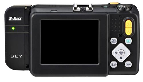
Ricoh Americas Corporation announced a new module for Ricoh digital cameras that provides the most advanced solution for precise, secure and portable military-grade photo/video geotagging.
Available in August, the thumb-sized Ricoh SE-7 GPS hardware module bolts on to the ruggedized Ricoh G700SE digital camera. This combination enables users to automatically geotag images with location information immediately useful in navigation, mapping, planning, analysis, strategy, reporting and more.
“The SE-7 module gives the military and other users important new capabilities for fast, precise and secure geotagging under less-than-ideal conditions,” said Yuki Uchida, Vice President, New Business Development, Ricoh Americas Corporation. “There’s a lot going on in this ultra-compact module to help soldiers and others be more successful in their work.”
According to the announcement, the module, which sets a new standard in global positioning system (GPS) speed and accuracy, offers a more compact and convenient geotagging solution than traditional systems requiring a laptop-camera combination. The SE-7 also generates location coordinates down to the meter, which is far more precise than consumer-grade products. For even better accuracy, the Ricoh G700SE/SE-7 combination is forward-compatible to 18-satellite GPS processing, a military standard scheduled to take effect in 2016.
Ricoh reports that the SE-7 module integrates directly with attachable laser range finders, includes a built-in compass for directional data capture, enables barcode tagging, and provides full support for selective availability anti-spoofing modules (SAASMs). SAASMs ensure GPS precision and accuracy even in the presence of malicious jamming and spoofing.
Tagging
The camera/module combination supports up to 20 memo fields that are customizable for tagging photographs with valuable data. Example data tags are photographer’s name, operation ID, operation type, unit ID and more. This information, along with GPS coordinates, GPS date and Zulu time, are automatically stored as metadata in each image file on the G700SE.
Mapping and direction
The SE-7’s GPS Track-Log feature maps the geographic path by which photographs are collected. An integrated electronic compass allows users to accurately record the direction in which a photograph is taken regardless of the angle at which the camera is held. After images are collected in the field, data is uploaded using the camera’s built-in wireless, Bluetooth or USB connection in preparation for analysis, mapping and reporting.
Formats
GPS coordinates collected with the SE-7 module can be displayed in a variety of formats directly on the camera, including LAT/LONG, MGRS, UTM and combinations of each, depending on user requirements. Data is compatible with a broad range of software, and images are plotted as a spatial data layer along with tagged information.
Laser range finder integration
Range finder integration allows users to tag not only where the picture was taken, but the location of objects in the distance being photographed.
On July 9, Boeing shipped the third of 12 GPS IIF satellites for the U.S. Air Force from the company’s Satellite Development Center in El Segundo to Cape Canaveral Air Force Station, Florida, aboard a Boeing-built C-17 Globemaster III airlifter.
SVN-65 is scheduled to be launched in the fourth quarter of this year aboard a United Launch Alliance Delta IV rocket. It will join the first and second Boeing-built GPS IIF satellites, launched May 27, 2010, and July 16, 2011, to continue the sustainment and modernization of the GPS network.
“As each IIF satellite becomes operational, we continue the seamless transformation of the GPS constellation into an even more accurate, reliable and durable navigation resource for the U.S. military and the global civilian user community,” said Craig Cooning, vice president and general manager of Boeing Space & Intelligence Systems. “Our efficient pulse-line manufacturing process, adapted from Boeing’s commercial airplane production lines, also ensures that we deliver each spacecraft on time and on cost.”
SVN-65 will now undergo preflight checkout, fueling, and integration to prepare for the early October launch. When on orbit, it will be controlled by the Operational Control Segment, the GPS network’s ground control system. Developed by a Boeing-led team, the OCS entered service in 2007 and was turned over to the Air Force 50th Space Wing in April 2011.
GPS IIF features greater navigational accuracy through improvements in atomic clock technology, a more secure and jam-resistant signal for the military, and a protected, more precise, and interference-free civilian L5 signal for commercial aviation and search-and-rescue operations. Other enhancements to the IIF include an extended 12-year design life and a re-programmable on-orbit processor that can receive software uploads for improved system operation.
Of the remaining nine IIFs that Boeing is building for the Air Force, three are complete and in storage, and six are being assembled and tested.
The Royal Institute of Navigation has awarded the Duke Of Edinburgh’s Navigation Award for Technical Achievement to Professor Nicolai Testoedov, who received it on behalf of Yuri Urlichich, the chief designer of GLONASS, “in recognition of the achievement of a complete operational constellation of satellites in December 2011, thus providing a full global positioning and timing service.”
This award honours a specific achievement by a team or individual in the field of navigation systems development, research, or education. The presentation was made at the RIN Annual General Meeting on July 11 by Sir John Charnley, a past president of the Institute (in the absence of Prince Philip who was engaged in a Diamond Jubilee event). The award has been instituted to mark the 90th birthday of His Royal Highness The Prince Philip, Duke of Edinburgh, Patron of the Royal Institute of Navigation.
In 2011, the RIN’s Technical Excellence Award changed its name, becoming the Duke of Edinburgh’s Navigation Award for Technical Achievement. In that year, it was awarded awarded to Barry Wade of Kelvin Hughes for his work on the SharpEye radar system.
Trimble has announced that its latest generation of GNSS receivers for marine construction and hydrographic survey now support Fugro's Marinestar positioning services. Using satellite-delivered Marinestar corrections with Trimble SPS855 and SPS555H GNSS receivers, contractors can conduct dredging work up to 20 miles offshore, without relying on land-based infrastructure such as reference stations and radio networks. The Fugro Marinestar positioning service expands the operating environment for contractors using the Trimble marine construction GNSS receivers and enables decimeter accuracy for precise placement of dredging equipment and dredged materials.
The Trimble SPS855 GNSS Modular Receiver provides accurate water level information and tidal height for a construction or dredging location, which is significantly more cost-effective than with conventional methods. Its modular design means the contractor can place the receiver inside the vessel cabin for maximum security and protection from the environment while mounting the GNSS antenna outside for optimized signal strength. The Trimble SPS555H Heading Add-on Receiver provides exact heading information for projects that require precise orientation of a dredging vessel.
The Marinestar positioning service from Fugro offers two options: Marinestar GPS — a high-performance, high-accuracy GPS augmentation service; and Marinestar GNSS — a high-performance augmentation service for both the GPS and GLONASS.
The new Trimble SPS855 GNSS Modular Receiver and SPS555H Heading Add-on Receiver are available now through the Trimble Marine Construction distribution network. Subscription to the Marinestar GPS and Marinestar GNSS service is available for dredging and other marine construction applications through Fugro.
Trimble has announced that the Trimble GCSFlex Grade Control System for Excavators now offers highly accurate GPS machine guidance via Wi-Fi. By serving GPS corrections over a Wi-Fi connection from a local base station, Trimble has eliminated the need for a radio network on the construction site and made it easier than ever to deploy GPS for a broad range of excavation work, the company said.
Trimble introduced GCSFlex Grade Control System for Excavators in 2011 as an affordable, easy-to-use machine control system for owner operators and small to mid-sized contractors who want to increase their productivity and competitiveness. With several system configuration options available, contractors can select the sensor options that fit their job site needs at a price point that fits their budget.
The new configuration of GCSFlex is deployed with the innovative Trimble SPS985 GNSS Smart Antenna as a local base station for transmitting GPS corrections to the excavator. The operator needs only to position the Trimble SPS985 base station and power it on to automatically establish a Wi-Fi connection and begin broadcasting corrections to the machine. With simplified daily setup and operation, Trimble has made the highly powerful GCSFlex system easy to deploy and use, even for excavator operators with little or no experience with machine control.
GCSFlex with GPS Guidance also offers the benefit of using in-field design templates created directly from the cab on the Trimble CB450 Control Box. This allows the excavator operator to very accurately dig to a desired depth, slope or alignment without creating a digital design in the office.
Trimble announced a new UHF RFID Reader accessory for its Nomad rugged handheld computer.
The Trimble ThingMagic Reader supports reading and writing of EPC Global Gen2 tags which are commonly used for asset and inventory management. The UHF RFID Reader accessory is designed to withstand drops, vibration, humidity, extreme temperatures and immersion, making it ideal for challenging environments.
"The Nomad has been a very successful rugged mobile platform, supplying field workers with a robust tool for data capture and navigation," said Jim Sheldon, general manager of Trimble's Mobile Computing Solutions Division. "The RFID Reader further extends the Nomad's capabilities and offers enterprise management more options in its use."
"Similar to the widespread integration of GPS into today's positioning solutions, we believe RFID is a natural complement to many asset management applications and Trimble solutions," said Tom Grant, general manager of Trimble's ThingMagic Division. "Integrating high-performance RFID technology into high-value products like the Nomad delivers a strong platform for next generation productivity applications."
The UHF RFID Reader is available in two variations: one for use in Europe, and the other for use in the U.S., Canada and most of South America. The Reader is based on the best-in-class ThingMagic M5e Compact UHF RFID module, and includes device drivers and a Software Development Kit to enable systems integrators to add RFID capabilities to their mobile applications.
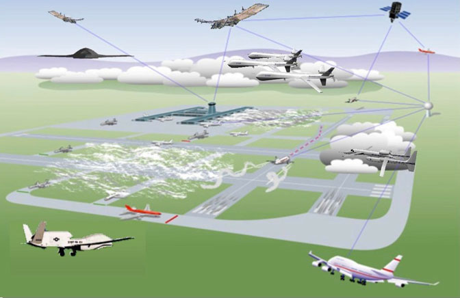
While the FAA is moving ahead with plans for UAS/UAV to have regular access to U.S. airspace by 2015, a number of barriers remain. For UAVs to be treated like manned aircraft, their systems likely need to be qualified to the same standards as civil avioncs — this is a challenge, as each UAS has largely unique systems. UAS equipment standards are emerging, but threats to GNSS abound and defense/mitigation is required. The coming AUVSI convention in Las Vegas in August may provide some answers.
Today’s demand for a wide range of unmanned aerial systems (UAS) has resulted in a lots of different types flying today in many applications. With no apparent standard avionics fit or uniform safety standards, each UAS type is basically configured for specific tasks. As commercial applications for UAS emerge, major market growth is anticipated. One forecast indicates that the UAS market could reach $7.26 billion this year alone. The promise of new and better ways to reduce costs, improve safety, and for more efficient operations is feeding a real market expansion.
However, in the U.S. the FAA currently requires each UAS commercial project desiring access to controlled airspace to obtain an FAA-approved Certificate of Authorization (CoA). While the FAA has made efforts to speed up approvals, this process has put a damper on widespread commercial adoption of UAS. Nevertheless, opportunities abound in pipeline and transmission line inspection, crop spraying, expanded law enforcement/security, and hundreds of other applications. The FAA may have felt some pressure to move forward, because Congress has put in place the Modernization and Reform Act of 2012, which calls on the FAA to fully integrate unmanned systems, including those for commercial use, into the national airspace by September 2015.
Cadence Technologies SR-20.
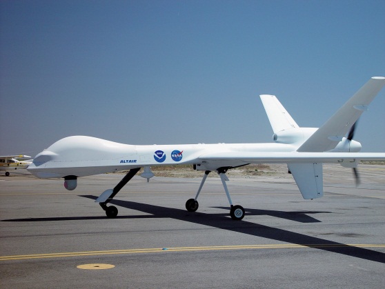
Meanwhile, a project called the Unmanned Aircraft Systems Integration in the National Airspace System (or UAS in the NAS) undertaken by NASA’s Dryden Flight Research Center at Edwards Air Force Base, California, seeks to reduce technical barriers related to safety and operational challenges associated with enabling routine UAS access to the NAS.
Civil aircraft and UAS may co-exist after September 2015.NASA Predator test vehicle.
Europe is also undertaking a study on the integration of unmanned aerial systems (UAS) in non-segregated airspace for the future “Single European Sky”. The study, known as ICONUS (Initial CON OPS for UAS in SESAR), will be carried out by a consortium within the European air traffic management program called SESAR. The group is led by France’s ONERA, and includes AVTECH (Sweden), CIRA and Deep Blue (Italy), ENAC (France), and INTA (Spain) — all have significant experience with UAS. The study will allow the definition of the requirements, capabilities, and the equipment that UAS will need to operate safely and efficiently in the coming European SESAR environment.
In the U.S., the RTCA SC-203 committee is busy drafting UAS operational requirements, and there has been significant progress towards ultimately publishing Minimum Aviation Performance Standards (MASPS), including requirements for navigation. Europe also has similar activities under way aimed at improving UAS access to their airspace.
The big picture is that requirements for unmanned aircraft are being brought into conformance with the standards applied to the performance and behavior of manned aircraft. Navigation requirements for UAS are expected to specify that systems will need to be qualified to Minimum Operational Performance Standards (MOPS). This means that on-board electronics, including GNSS systems, will probably need to be FAA TSO qualified, just as they are now for manned aircraft.
But why do we need to investigate certified avionics now? In the scheme of things, +2 years of breathing space to certify UAS avionics systems is not long before the September 2015 deadline. FAA airborne software and hardware qualification will take mucho time and effort to implement, and reconfiguration of systems, interfaces, and operating procedures may take even longer.
UAS manufacturers have the option to move forward in stages — for instance, by selecting a few existing airborne qualified OEM avionics, they could minimize the internal effort to comply. And as the first UAS with certified avionics emerge, they will probbaly get good support from FAA to adopt the rules of operating in the U.S. NAS. Embedding an existing certified GPS receiver in UAS avionics will reduce the level of internal work needed and will allow more effort for developing commercial market opportunities which are looking to quickly adopt UAS.
And while this is going on, efforts are in full swing to change the navigation landscape in the U.S. and Europe over the next few years. So it would be better to be ready with a capable GNSS receiver that is already built to meet the challenges of the FAA NextGen and SESAR environments.
The L5 civil GPS frequency may likely be operational around the time that UAS unrestricted access becomes possible. GPS L1/L5 dual-frequency operations will enable higher navigation accuracy, reliablity, and integrity. The FAA is already developing NexGen WAAS to include L5, and revisions to the GPS MOPS to include L5 are anticipated to begin shortly, in time for a usable GPS L5 constellation in 2015/2016.
The FAA is already preparing for L5 avionics, and industry investigative work is under way. It’s possible that GPS L1/L5 may well meet the accuracy and integrity requirements for CAT II/III automated landings. And in Europe, Eurocae work is expected to gain momentum for the Galileo E1/E5a MOPS as the Galileo satellite navigation system is launched and becomes operational.
The new GNSS environment also includes WAAS/SBAS precision approach (LPV) capability — LPV is available now in the US and will soon be in wider operation in Europe. And Automatic Dependendant Surveillance (ADS-B) is being rolled out in the U.S. and around the world. ADS-B is being mandated within the U.S. NAS as the means for air traffic control to track all aircraft, so UAS avionics will need to include certified ADS-B Out capability.
The Septentrio AiRx2 receiver comes out of the box as a certified L1 GPS with ADS-B and WAAS LVP, but is also ready for GPS L5 and Galileo E1/E5a.
Photo: Septentrio
And yet, even as greater steps forward are being taken to enhance how GNSS is used in this wider definition of aviation, which will soon include UAS, a team at the University of Texas was busy demonstrating how a UAV could be maliciously side-tracked (see article in the August issue of GPS World). Their recent tests at White Sands Missile Range used a spoofing set-up built in their lab to significantly affect the trajectory of a Hornet Mini UAV. Admittedly, the GPS on this vehicle was not a qualified airborne receiver, but there were other sensors on board the vehicle which may have been able to indicate that the GPS had been hijacked. The spoofing set-up used a high-power directional signal to overwhelm the real GPS signals and “distract” the GPS on-board receiver. Nevertheless, they were able to force the hovering UAV down towards the ground — somewhat reminiscent of the Iranian downing of a U.S. surveillance drone in December last year.
How could this happen when there was also an inertial sensor and a radio-altimeter on the UAV? A good question, which UAV manufacturers will need to consider when they implement their on-board Kalman filters, knowing that spoofing is now an additional threat to combat. But, couldn’t we detect that high-power RF spoofing signal at the front-end of the GPS receiver? Even if only to tell the on-board systems that there could be Hazardous Misleading Information (HMI) about? Or run separate GPS and GPS/inertial position solutions, detect significant divergence, and set the same warning flag? And multi-constellation, multi-frequency receivers, and even controlled radiation pattern antennas — all things to investigate, and even more effort for the aviation receiver guys who are always working tirelessly to improve the integrity of GNSS positioning.
Of course, if you hijack a UAV with a high-power spoofer, you are also spoofing civil transports operating in the same airspace — so now there is the potential to trigger a federal investigation. And it will probably be easier to detect this stuff with moving airborne sensors rather than the fixed ground equipment used to find jammers on trucks at Newark Airport, and lots of pilots likely providing real-time location information on radios if their GPS goes even a little haywire — all would help to quickly locate and shut down any spoofer. Nevertheless, it’s a threat to be mitigated.
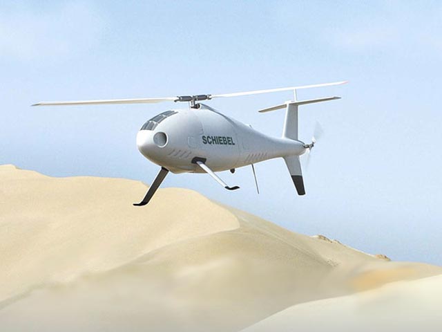
In South Korea, the effects of intermittent North Korean jamming of GPS to disrupt navigation at sea, on land, and in the air in the south may have contributed to the recent fatal crash of a Schiebel Camcopter S-100 drone — a 150-kilogram rotorcraft capable of 220 km/h flight, which should have coped with loss of GPS as the Camcopter has multiple inertial measurement units that “allow safe operation and recovery in the absence of GPS signals.”
Schiebel Camcopter S-100.
Schiebel, however, has indicated that information recovered to date indicates that after the loss of GPS signals to the aircraft’s receivers, there may have been incorrect handling and operator errors which resulted in an unfortunate chain of events that ultimately led to the crash.
Emergency procedures “to ensure a safe recovery in such a situation” do not appear to have been “correctly and adequately followed,” Schiebel alleges.
NovAtel may have found one way to help mitigate spoofing on UAVs — they just released a combined civil/SAASM GPS receiver, the OEM625S, aimed specifically at UAVs. Granted, the idea is to add SAASM anti-spoofing capability to a number of UAVs which currently use NovAtel commercial receivers — mostly in military systems. And of course that may well be motivated by the desire to avoid any further Iranian incidents!
BAE Systems has obviously been thinking of giving GPS a back-up for just those situations where jamming or even spoofing is detected. BAE’s system was just announced at the Farnborough Air Show in the UK and is still in the research phase, but looks extremely promising. Known as Navigation via Signals of Opportunity (NAVSOP), it interrogates the radio environment for the ID and signal strength of local digital TV and radio signals, plus air traffic control radars, with finer-grained adjustments coming from cellphone masts and Wi-Fi routers. Mapping the locations of all these sources might be quite an undertaking, and given that these are all non-safety-of-life commercial signals, the sources are subject to the vagaries of power outages, regular maintenance, and breakdowns. Nevertheless, with such a multitude of signals, NAVSOP could well turn out to be a viable back-up for GNSS.
Meanwhile, the Association for Unmanned Vehicle Systems International (AUVSI) big show is set to run August 6-9 in Las Vegas. With more than 500 exhibitors, attendance is expected to be more than 8,000 people from all over the world. All the key manufacturers, suppliers, and users of UAS are expected to be there, so it’s a great opportunity to meet people working with UAS and see some of the hardware and systems. Hopefully we will be able to get a feel for how the industry sees the onset of commercial market opportunities and the changes this may mean to systems and vehicles. It will be my first time walking round all these exhibits and seeing the live demos, so I’m very excited to be able to find out even a little about what makes this industry tick! More on this later…
So, shared access to civil airspace, wider applications in commercial operations, and changes in equipment qualification — along with potential solutions for GNSS jamming and spoofing — lots to consider for the UAS industry.
Last weekend, I attend the Survey Summit in San Diego, which is sponsored by Esri with participation by ACSM/NSPS. As usual, there’s was some great content, but it’s not all good news. On the other hand, attendance at the Esri International User Conference, which started on Monday, was at 16,000 and counting. That’s up considerably from last year.
Survey Summit
The agenda for the first day of the Summit was different this year, and better. It was mostly a set of Lightning talks, followed by some technical presentations, and rounded off with a keynote. The lightning talks were very good. I like that style, get to the point and show what you have
Hemisphere GPS, a leading innovator and manufacturer of advanced GNSS products, continues to expand its intellectual property portfolio with newly awarded patents. These patents represent the latest advancements in adaptive machine control and GNSS solutions, the company said.
The Adaptive Machine Control System and Method patent describes the sophisticated adaptive control methods used to guide vehicles and provide accurate and efficient coverage. The system is comprised of a machine controller, GNSS guidance system, and software and is most commonly used in precision farming. From pre-planned guidance patterns the system provides the ideal pattern adjustments for guidance and automated steering taking into account a variety of conditions and user inputs including path, boundary or terrain irregularities, and minimum turning radius. In addition, the system provides optimal, automated turns and spray nozzle control. As a result, farmers complete their fieldwork with greater accuracy and efficiency as well as improve their yields and reduce their input expenses. The patent supports current products and new developments within Hemisphere GPS’ precision farming product line including Outback Guidance branded products.
Hemisphere GPS was awarded seven other patents in 2012 that include advanced GNSS solutions for antenna design, an application specific integrated circuit (ASIC), multiple antenna control system, tracking of fixed and slow-moving structures, augmentation of differential corrections, antenna alignment and monitoring system, and vehicle guidance control.
"Hemisphere GPS’ commitment to innovation has generated over 75 pending and issued patents,” said Mike Whitehead, chief scientist at Hemisphere GPS. "Through these inventions and sophisticated new technology, we continuously enhance capability and performance of our positioning, guidance, and machine control solutions in the marketplace.”
Topcon Positioning Systems (TPS), announces the release of a new mobile GIS field software – eGIS.
According to the announcement, eGIS is compatible with Topcon’s FC-25, FC-236, Tesla and GRS-1 controllers, and makes all accuracy capabilities from autonomous measurements to RTK centimeter level accuracy easy to achieve. The new software makes it easy to collect and maintain databases for a variety of uses – electric utilities, gas pipelines, disaster management, water and wastewater operations, forestry, highway maintenance, environmental studies, as well as other mapping projects.
Jason Hooten, TPS national sales manager for GIS products, said, “As applications for GIS data collection continue to expand, we are pleased to offer an easy-to-use field software solution. The customization and graphical interface aspects of this software make it very simple to collect, view, download and export GIS data.”
Key features of eGIS include:
• ESRI compatible (Native Shapefile format);
• Fully integrated GRS-1 GNSS functions;
• Capture, edit, analyze and display geographic information;
DeLorme today announced at the Esri Users Conference the introduction of ArcSync, a software engine that allows customers to transfer field data edits to Esri repositories and synchronize field databases with the internal GIS database.
ArcSync automates the process of defining and scheduling tasks, providing automatic data flow and keeping field and office databases in sync.
“The ArcSync engine is an automated tool that streamlines the synchronization between field data collection and the ArcGIS database at headquarters,” said John Auble, DeLorme vice president, data products and HA/DR programs. “It is the ideal solution for organizations with a need to collect and distribute GIS data to field personnel in a disconnected format. It creates disconnected GIS layers from ArcGIS feature classes and maintains synchronization as changes are made via DeLorme, ArcMap, or other Esri tools.”
Auble noted that ArcSync permits the GIS Admin to ensure data viewed in the field is current for both the connected and disconnected GIS user, pushing work tickets to field personnel in an automated fashion so that critical data can be collected in a timely manner. It also allows for a scheduled automated process to run in order to make sure that all databases are in sync, eliminating the need for GIS Admin to spend time processing files manually to keep the field database and internal GIS database synchronized.
DeLorme is showcasing its full range of mapping, positioning and tracking solutions in Booth 2407 at the 2012 Esri Users Conference this week in San Diego.
Altus Positioning Systems has made three announcements at the Esri 2012 Users Conference in San Diego this week. The company introduced a new GPS-based data-acquisition system for the GIS industry, introduced a portable integrated system for GIS applications, and announced the commercial availability of a GNSS receiver.
New GIS system. Altus introduced a new GPS-based data-acquisition system for the GIS industry. The new system from Altus includes an ikeGPS multi-sensor data-acquisition system and a variety of built-in software tools for specific data-collection projects.
The ikeGPS product combines a GPS receiver, laser rangefinder, 3D compass and digital camera in a single ruggedized handheld device, providing a fully integrated low-cost solution for capturing geospatial data and 3D GIS imagery. The versatile system permits the user to geolocate objects quickly and easily from a single location with the laser rangefinder and compass, using the recorder’s GPS coordinates as a reference. The digital camera provides a visual reference for each object captured into the database, and the system can even calculate position coordinates for target items directly from the photographs.
“The ikeGPS multi-sensor platform enables the capturing of GIS data in situations that would be otherwise impossible using traditional GIS equipment,” said Neil Vancans, CEO and president of Altus Positioning Systems. “The ikeGPS mobile GIS solutions provide unique improvements on conventional GIS data-collection efficiency. It also enables the user to capture accurate measurements of remote objects — for instance, across a busy highway, barbed-wire fence, or stream — from safe distances with its point-and-shoot capability, producing verifiable, geo-referenced data collection.”
Vancans noted that for applications requiring higher-precision positioning, the ikeGPS device can be interfaced with Altus’ APS-3 GNSS RTK survey-grade receivers for centimeter-level accuracies.
Portable Integrated System for GIS Applications. Altus also introduced the new ProCyon, which integrates the flexible, rugged Psion Workabout Pro handheld computer with Altus’ APS-3 RTK GNSS receiver for a powerful GIS data-acquisition platform, the company said.
The ProCyon system delivers one-centimeter RTK accuracy using an external antenna, integrated camera, and quad-band GSM modem. Additionally, the ProCyon has hardware expansion slots, making the addition of new modules fast and easy, as well as a range of available add-ons, including fingerprint scanners and the largest selection of RFID readers on any handheld device, Altus said.
The ProCyon Windows Mobile operating system accommodates ESRI ArcPad and ArcGIS applications. Both programs use NMEA messages that are standard outputs from the integrated GNSS receiver in the ProCyon.
“The ProCyon is built on the industry-standard platform of the Psion Workabout, one of the world’s top-selling Windows Mobile devices,” said Neil Vancans, CEO and president, Altus Positioning Systems. “The ProCyon is an answer to the needs of many utilities already using Psion products.”
Commercial Availability of GNSS Receiver. Altus Positioning Systems also announced the commercial availability of its new APS-U GNSS receiver. For maximum flexibility, the APS-U is scalable from a single stand-alone GNSS receiver to full options with heading, wireless links, precise point positioning, and RTK capability. The unit has an additional processor for on-board configuration and custom applications separate from the GNSS engine. It has an extensive suite of interfaces for data output, timing, event marks and a second antenna port for GNSS heading.
“The APS-U provides multi-frequency capability together with GNSS heading, L-Band positioning and wireless communications, all within a hardened housing that meets military environmental specifications,” said Neil Vancans, CEO and president, Altus Positioning Systems. “With its wide range of interfaces and 9-30V power input options, the APS-U is an ideal GNSS solution for GIS data collection as well as machine control, agriculture, aerial photogrammetry, heading sensors and military applications. It can also be used in a variety of different formats, without heading information, in a robust receiver or base station configuration.”
The 136-channel receiver is designed to use all GPS, GLONASS, and Galileo frequencies. Integrated wireless options include Bluetooth for easy configuration, plus a GSM or CDMA cellular modem and UHF radio modem for transmission and reception of RTK corrections. It also works with WAAS, EGNOS, and other satellite-based augmentation systems.
The rugged new APS-U units incorporate Septentrio GNSS receiver engines, and meet MIL-STD-810G specifications for humidity, dust, shock, and vibration, and operates under temperatures from 30 to minus 65 degrees Celsius.


 Portable Integrated System for GIS Applications. Altus also introduced the new ProCyon, which integrates the flexible, rugged Psion Workabout Pro handheld computer with Altus’ APS-3 RTK GNSS receiver for a powerful GIS data-acquisition platform, the company said.
 Commercial Availability of GNSS Receiver. Altus Positioning Systems also announced the commercial availability of its new APS-U GNSS receiver. For maximum flexibility, the APS-U is scalable from a single stand-alone GNSS receiver to full options with heading, wireless links, precise point positioning, and RTK capability. The unit has an additional processor for on-board configuration and custom applications separate from the GNSS engine. It has an extensive suite of interfaces for data output, timing, event marks and a second antenna port for GNSS heading.