Author: Don Jewell

  • September budgeting surprises: Scarcity or surplus?

    September budgeting surprises: Scarcity or surplus?

    Halloween may occur in October for the civil and commercial population, but for the U.S. government (USG) all the craziness of the spooky season starts in earnest in September. The end of the USG’s fiscal year (FY) ends the last day of September, and Oct. 1 is a whole new ballgame from a monetary and budgeting perspective.

    All the machinations begin: balancing budgets, ensuring monies have been fully allocated and spent, determining surplus funds and figuring out what programs need additional year-end funds.

    Certainly the process begins far in advance of September, but the last 30 days of the FY are historically a circus. Anyone who has ever been through it, especially as a budgeteer or program director, knows the anguish and anxious moments involved. If you think this all sounds a bit more dramatic than necessary for simple funding and budgeting issues, then think again.

    Budgeteers inside and outside the USG (prime contractors and small companies as well) are all vying for what is known as fallout money. These are funds that “fall out” because a program has failed to meet timelines, specifications or certifications; funds that fall out because a program came in early and under budget (a rarity); or funds that fall out just because of over-confidence in flying hours or lack of equipment availability. Regardless of the reason, the fact is that fallout funds at the end of the FY have significant impacts on all USG programs.

    For example, as a PM or program manager, if your program is doing well and maybe even ahead of schedule, and the customer is chomping at the bit to put your hardware or software in place, then you might be allocated additional fallout funds as a sign of confidence and support from the government. This is what Program of Record (POR) PMs love to see happen, because it means there is faith in their program and in their ability to manage it and bring it home; this can include promotions and more responsibility on the horizon.

    Conversely, if your program is in trouble, over budget and behind schedule, and the USG lacks faith in your ability to complete the POM (Program Objective Memorandum), then your funds may well be cannibalized to support other programs. This is something no PM likes to see happen. It is a downer for the USG, the POR and the career of the PM. Yes, for PMs, every September is a report card, and the grades are rarely ambiguous or subtle.

    Of course, the organization that allocates and authorizes USG funding at the beginning of the FY, better known as the U.S. Congress, plays a role here as well; many take a vacation or flee to the hinterlands during this time of bureaucratic chaos and get out of town. For 2016 and the 114th Congress, the Senate is in session just 14 days of the month and the House of Representatives convenes for about 10 days on average.

    As the former Legislative Director (LD) for Air Force Space Command (AFSPC), I actually had the honor to serve as the first LD for AFSPC. This worried me a great deal until I discovered that, fortunately, while a few congressional members were in recess or at home backslapping and politicking with constituents, the congressional staffs remained in D.C. and were hard at work. This is important because, during the craziness and bargaining of September fallouts, critical decisions are often made that determine the future of PORs and many smaller but critical efforts by small businesses as well. If you are a government contractor, small or large, prime or sub, September is not a time to take a vacation or lay on the beach, rather you need to be an active player in the fall flurry of hyperactivity.

    This year Senator John McCain from Arizona and the SECDEF (Secretary of Defense) the honorable Ash Carter both have plans and are pushing for new acquisition strategies as well as separate schemes to revamp Department of Defense (DoD) Command and Control systems. Unfortunately, neither plan has a support system for small businesses.

    Space Systems

    SpaceX launch of an OrbComm satellite in December 2015. (Photo: Space X)
    SpaceX launch of an OrbComm satellite in December 2015. (Photo: SpaceX)

    For space programs this coming year, obviously current and future launch activities are at the forefront. Congress must decide to either fund Russian engine procurement or say no to future Russian engine purchases, determine whether the United Launch Alliance (ULA) is a survivor and competitor, and decide where SpaceX plays in the whole scenario now that they have thrown a monkey wrench into the mix by experiencing another Falcon 9 failure on Sept. 9 after so many successes.

    Interestingly, SpaceX actions in the main seem to be the right decisions. They are at the forefront of commercial launch and recovery technology, and other than Blue Origin, they are the only company recovering the initial stages of their launch vehicles for reuse. Of course that reuse can only occur if the launch is successful in the first place.

    While SpaceX certainly cannot afford more launch failures, the conundrum concerning the latest Falcon 9 catastrophe is that it was not actually a launch failure; rather, it was an accident that occurred on the launch pad. Who knows? Future investigations, performed primarily by SpaceX and the FAA, may show SpaceX was not at fault.

    The fueling explosion could easily have been caused by a ruptured refueling hose, a stray spark or ungrounded support equipment, we just don’t know. It is entirely too early to rush to judgment and blame it all on SpaceX. We should and, indeed, must take a wait and see attitude.

    However, just so you know for comparison, ULA has performed more than 100 successful launches without a single failure. Many of those used the infamous Russian RD-180 engine as a core. So, to say that launch is a topic of national and Congressional concern during the September chaos is putting it mildly.

    SV 01 in testing at Lockheed Martin's Denver facility. (Photo: LMCO)
    SV 01 in testing at Lockheed Martin’s Denver facility. (Photo: LMCO)

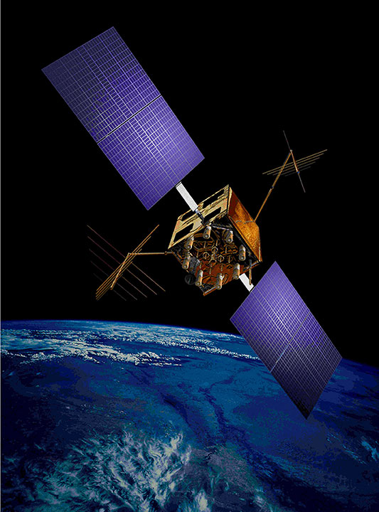
    According to my sources, an omitted qualification test of a tiny capacitor in the GPS III payload will move the GPS III program’s availability for launch (AFL) from August to December 2016. My sources and my experience as a space operator tell me the qualification test — which over-stresses the capacitor’s integrity to survive multiple mission lives — is really not an issue. The satellite should be delivered before the end of the year, well ahead of the Air Force’s planned first GPS III launch date of March 2018.

    My experience also tells me that it is much more likely that, rather than a tiny capacitor issue, the launch schedule for the first GPS III will be affected by the as-yet-unresolved SpaceX explosion on the launchpad at Cape Canaveral; the damage to the launchpad and nearby facilities; the launch slips due to the ripple effect of the subsequent accident investigations, along with new safety and fueling procedures that may need to be implemented and tested; the rescheduling of other missions, handled in the military by the USAF Current Launch Schedule Review Board or CLSRB; and the lack of an available MEO (Medium Earth Orbit)-capable launch vehicle.

    And, of course, you need a ground control system (which I go into more below).

    Position, navigation and timing (PNT) programs

    Concerning PNT, Congress is debating when to award Lockheed Martin GPS III satellites 9 and 10, which by the way, will not carry an NDS (Nuclear Detonation Detection System) payload, a first for GPS space vehicles (SV) since the first NDS was launched on the sixth Block I SV on April 26, 1980. At the time, the NDS payload was known by the ungainly moniker IONDS, or the Integrated Operational Nuclear Detonation Detection System.

    The new, redesigned NDS payload is simply not ready for prime time, and hence LMCO will delete that portion of the payload from GPS III SVs 9 and 10. So, although the GPS III family of GPS vehicles will be as similar as possible, in fact the last two, currently scheduled (which we hear may be awarded to LMCO this month), will be radically different in some respects, and in others be exactly the same.

    This leads us to the question concerning exactly when the real competition for GPS III SV 11+ will truly get underway. Right now, the competition is in the formative and PowerPoint stages for some competitors, although a couple have bent hardware and are writing some software support programs. The USG has awarded each team, including LMCO, a few million dollars to keep them interested and to defray early non-recurring costs, but the competition has yet to truly heat up. Might some year-end fallout money be made available for the competitors? We shall have to wait and see.

    OCX

    OCX, the future ground control segment of GPS, is so far over budget and schedule that the end-point is not even visible on the event horizon. Most pundits put the completion date, if it is continued as the POR, at 2023 and beyond, seven years late and $3.5 billion over budget.

    Certainly no fallout funds can cover such a Nunn-McCurdy breach, but fallout funds might become available for alternative courses of action (COA). There’s a thought to keep USG budgeteers and small company CEOs and CFOs awake at night.

    What might the future hold? Large primes not withstanding, small businesses are a major player in all major USG programs. Karen Mills, former head of the Small Business Administration (SBA), wrote in the Harvard Business Review recently, “Half the people who work in this country [USA] either own or are employed by businesses with fewer than 500 employees.”

    At the same time, the Wall Street Journal (WSJ) reports that SBA statistics show these same small companies produce 46 percent of private economic output and 33 percent of the value of U.S. exports. Even so (paraphrasing the report), the [USG] is sometimes guilty of not paying sufficient attention to small firms. Is it time for the USG to look at proven small-company capabilities where OCX is concerned?

    Just a thought, whose time may well be long overdue. As Nitin Nohria, dean of the Harvard Business School, wrote in the Wall Street Journal, “I do hope that the question of how to create policies that support small companies gets more attention during the coming debates and the final few weeks of this presidential campaign.”

    Research and development (R&D)

    We could go on and on considering PNT or GPS military user equipment (MUE), the advantages of GNSS considerations and the R&D being conducted at AFRL (USAF Research Laboratories) and the other service labs where PNT is concerned. (Read my In defense of PNT: Multi-GNSS to the rescue, May 11, 2016, Defense PNT column)

    Of course, let’s not forget DARPA (Defense Advanced Research Projects Agency). As experienced PMs know, you neglect DARPA at your program’s peril. DARPA waxes and wanes on the publicity scale, but they are always on the cutting edge where R&D is concerned. Many of our nation’s most noted scientific accomplishments began life as DARPA hard projects, way too many to mention. DARPA, like all R&D laboratories, have their hands out and are just hoping for and are ready to commit any fallout monies that become available in scary September.

    If you are wondering why no one in Washington, D.C., is returning your calls and emails, or why they seem distracted or preoccupied when you are able to connect, just blame it on the most chaotic month of the USG budget year, September. It’s feast or famine, or you could say, early trick or treat.

    ION GNSS+

    Prevailing health issues prevent me from traveling to ION GNSS+ 2016, which takes place Sept. 12-16, at the Oregon Convention Center in Portland, Oregon. ION bills this event as “the world’s largest technical meeting and showcase of GNSS technology, products and services. This year’s conference brings together international leaders in GNSS and related positioning, navigation and timing fields to present new research, introduce new technologies, discuss current policy, demonstrate products and exchange ideas.”

    This is a great event, which I normally look forward to every year. Not to worry, GPS World is well represented by editors, writers and contributors. Be sure and stop by the GPS World booth — chat, pick-up a magazine while you’re there, and subscribe to the free print and/or digital editions.

    Until next time, happy navigating and remember: GPS is brought to you free of charge by the United States Air Force.

  • Considering GPS III in light of a PNT wager

    Considering GPS III in light of a PNT wager

    It was not a big wager as wagers go, at least not in monetary value, but the underlying premise of the wager spoke volumes. It all began innocently enough in 2005 when the first test, or proof of concept, Galileo satellite known as GIOVE-A was launched.

    In March of that year, a group of PNT experts made a simple wager that there will be:

    • 10 or fewer operational Galileo satellites by 12/31/15

    or

    • 11 or more operational Galileo satellites by 12/31/15
    Galileo's GIOVE-A retired in June 2012.
    Galileo’s GIOVE-A retired in June 2012.

    About 20 PNT experts took the bet, evenly divided on both sides, which essentially said that given that the first test (GIOVE) Galileo satellites were launched in 2005 and 2008 respectively, surely there would be at least 10 operational satellites on orbit or about one per year by 2015.

    The stakes were modest, but as I said, the import of the faith (or lack of faith) in the European Union and its ability and understanding of the difficulties involved in the Galileo endeavor spoke volumes. As the chief scientist at Air Force Space Command stated at the time, “This is rocket science; this is hard.”

    Chutzpah and/or naïveté

    But the Europeans refused to believe it was a very hard problem. Indeed, after the second GIOVE launch, GIOVE-B in 2008, the European ministers announced, with incredible chutzpah and/or naïveté, that the Galileo constellation would be fully operational (24 fully operational on-orbit satellites) by 2013.

    Of course, nothing of the sort has happened. Following the in-orbit validation (IOV) satellites, the first operational satellite launch did not occur until October 2011, almost six years later.

    As of May 2016, there were 12 operational Galileo satellites on orbit along with two in early orbit or checkout stages — a far cry from the predicted 24 operational satellites. This is not a criticism of the Galileo system; rather, a validation of those who took the pessimistic side of the wager and of the chief scientist who clearly stated the obvious: this is indeed, as a popular euphemism states, a DARPA hard problem.

    So the Europeans have been going about this PNT business since the initial decision to proceed in 2003 — 13 years. The United States has been producing and launching GPS satellites continuously since the first test launch of a NAVSTAR satellite in 1977 (39 years), with a continuously fully operational system (FOC) since 1995 (21 years), and guess what? It is still a hard problem. No one denies that. Which brings us to GPS III.

    GPS III Update

    Since the United States — specifically the United States Air Force (USAF) — has been in the space-borne PNT business longer than any other nation, you would think we would have this down by now. But it is still a hard problem with, fortunately, a long string of successes and very few (only two) failures.

    To date, the U.S. government has launched a total of 72 GPS satellites. There are 31 active operational GPS SVs (satellite vehicles) on orbit, with seven additional in residual or test status; 32 have been retired into a parking orbit where they will not interfere with the operational constellation. That equates to 1.85 GPS satellites launched per year on average, or one every 6.5 months — an enviable record, failures and all.

    Plus, there are GPS IIA satellites still on orbit that have been there for more than 22 years. Not bad for a satellite built to last (contracted service life) for 7.5 years.

    Amazingly, the payloads on every GPS satellite to date were built, in part, in partnership with or completely by one company, now known as Harris, nee Exelis, nee ITT. Of course, the complexity of the payloads being built by Harris for the GPS III satellites is a far cry from the payloads built in 1975 for launch in 1977. According to GPS III program manager and VP Mark Stewart and his cohorts at Lockheed Martin (LMCO), the aerospace company building the GPS III satellites, GPS III

    “…will deliver three times better accuracy, provide up to eight times improved anti-jamming capabilities and extend spacecraft life to 15 years [ed. contracted life], 25 percent longer than the [ed. latest family of satellites on orbit today]. GPS III’s new L1C civil signal … will make it the first GPS satellite to be interoperable with other international global navigation satellite systems.”

    While many of you may look upon that LMCO statement as marketing hype, in fact it is a rather incredible prophesy. To a PNT expert it translates to: almost all GPS users globally will have sub-meter level positional accuracy from a group of signals that will rarely if ever be completely jammed, from an SV with a projected lifetime of 30 years that has more signals and greater signal strength, flexibility and interoperability than ever before. By the numbers GPS is still, far and away, the world’s gold standard.

    So exactly where are we in relation to a launch of the first evolutionary GPS III satellite? After all, the last IIF launch, number 12 in the series, built by Boeing, occurred in February, so by the law of averages we should have the first GPS III launch later this month. That is not going to happen, but then what is a few months among friends when iterated over 39 years?

    Currently the first GPS III launch date, according to the USAF, is scheduled for May 2017. All indications are the government is on track to meet that date with, interestingly enough, the availability of a suitable launch vehicle being the LIMFAC (limiting factor), not the availability of an GPS III SV to launch.

    SV 01 in testing at Lockheed Martin's Denver facility. (Photo: LMCO)
    SV 01 in testing at Lockheed Martin’s Denver facility. (Photo: LMCO)

    According to my sources, GPS III SV-01 is fully integrated, has completed all environmental testing and is essentially ready to ship to Cape Canaveral,. It would be available for launch (AFL) sometime before the end of the calendar year if there were a launch vehicle, a ground control system and range availability.

    GPS III SV-02 will undergo full integration (“core-mating”) completion sometime this fall and — following successful completion of its environmental tests — should certainly be AFL in 2017.

    The complete navigation panel (from Harris) for GPS III SV-03 should arrive in the LMCO Denver facility early next year. Providing the vehicle stays on track through testing, it should be AFL in 2018.

    The government has yet to complete the contract award process for GPS III vehicles SV-09 and SV-10 to LMCO, but I am assured the award is imminent.

    My sources confirm that Harris is continuing to pump money, expertise and technology into the GPS III payload development process, a manufacturing tour de force, and the company should be back on schedule early next year.

    As for OCX, the future GPS Ground Control Segment, that is another tale for another time. For all other GPS III segments, all in all it is a positive message for development and deployment. Which is an admirable feat — after all, it is rocket science!

    By the way, the Galileo wager is open to interpretation. There were certainly more than 10 Galileo platforms on orbit on the last day of December 2015, but only nine of them were operational at the time. Both sides are claiming victory. What a surprise!

    A product to save your hearing

    The EB15LE with Hearing Defenders with accessories. (Photo: ERI)
    The EB15LE with Hearing Defenders with accessories. (Photo: ERI)

    Before I close, I want to mention a product I have tested as extensively as I can in a limited environment. I agreed to test this non-GPS product because of all the emails and letters I receive concerning tinnitus and how it negatively affects our warfighters. Several emails make clear the necessity and criticality of a good sight picture or display for GPS guidance, especially where exfiltration is concerned.

    When warfighters or law enforcement officers are suffering the ill effects of extremely loud noises, it is often disorienting. Much like the effects of a flash-bang device, a victim can lose his bearings and needs to have a clear visual of how to exit the threat environment.

    The best solution would be not to suffer the devastating effects of the loud noises in the first place. This is where a company named Etymotic Research Incorporated (ERI) comes into play. ERI has developed electronic hearing protection for law enforcement officers and military users.

    The version I tested was designated the EB15 for law enforcement. It functioned well as electronic hearing protection and amplification where needed. The device is essentially an electronic hearing aid that amplifies natural or quiet sounds up to five times, and a hearing defender that electronically blocks loud, harmful sounds by up to 25 decibels.

    While I was not able to test the hearing defenders in actual combat, the testing I did perform demonstrated that the EB15-LE is an impressive product with a plethora of earplugs for various noisy environments that may help save a user’s hearing. Our warfighters and law-enforcement officers deserve the best technology available, especially if it helps them retain their orientation in a dangerous environment and saves their hearing.

    Until next time, happy navigating, and remember: GPS is brought to you free of charge courtesy of the USAF.

  • The GPS Update Syndrome

    The GPS Update Syndrome

    Don Jewell
    Don Jewell

    The I-want-free-advice syndrome was once called the “Doctor Syndrome” or “Expert Syndrome.” I have recently heard it referred to as the “unsolicited advice” syndrome, because there is a new version that involves shaming the expert in to giving free advice.

    Occasionally those of us with expertise in an area of interest, which certainly include doctors and lawyers, are faced with tough decisions involving rules, regulations, laws and conflicts of interest.

    We are all guilty of these ethical violations in one way or another. On an airplane you discover your seatmate is a doctor of osteopathic medicine; not five minutes have gone by and you are telling him or her about all your aches and pains and seeking advice. My daughter, a clinical psychologist, says this frequently happens to her, but legally it is not a syndrome, although it could certainly be described as a phenomenon.

    Regardless of the nomenclature, the newest wrinkle goes like this, as stated by a congressman at our table at a fundraiser I attended recently, when he was asked about the troubled OCX program (Next Generation GPS Operational Control System) and GPS funding in general. “Well, I don’t know much about GPS or navigating, but this is what I know about OCX and GPS. I am sure Don will correct me if I am wrong…”

    I mention this phenomenon because for position, navigation and timing (PNT) issues, it is growing at an alarming rate. For instance, my 10-20 emails per day asking about PNT issues have grown over the past few weeks more than tenfold. I perceive that many of you are confused and concerned about the future of GPS, PNT and GNSS in general.

    With the House Armed Services Committee deleting more than $420 million from the GPS budget line for OCX in the 2017 budget and canceling funding for certain Acquisition, Technology and Logistics (AT&L) positions dealing with acquisition, there are all kinds of rumors and innuendo floating around. [Editor’s Note: the Senate did not make the same deletions, so this must be worked out in congressional committee meetings before the end of September]. So, I went out and formally asked the experts (GPS Directorate, Lockheed Martin and Harris Corp among others) what they think the future holds for GPS. Here is what I learned…

    Artist's concept of the nextgen GPS III satellite (courtesy of the USAF).
    Artist’s concept of the nextgen GPS III satellite (courtesy of the USAF).

    GPS III Spacecraft. According to Colonel Steve Whitney (USAF), the director of the Global Positioning Systems Directorate, Space and Missile Systems Center (SMC), Air Force Space Command (AFSPC), Los Angeles AFB, California: “The GPS III program is actively engaged in production of the first eight [GPS III] satellites (SV), while proceeding ahead with contracting actions for the ninth and tenth spacecraft. “

    Colonel Whitney went on to explain, “We have had several notable successes over the last year, including delivery of the first two navigation payloads [from Harris Corp] and completion of the first spacecraft’s environmental tests (acoustic, thermal vacuum and electromagnetic compatibility). As we prepare to accept delivery of the first spacecraft, the directorate is gearing up for the Mission Readiness Campaign and satellite launch.”

    I spoke independently with representatives from both Harris Corp and Lockheed Martin, and they expressed the same opinions. Work is progressing toward a launch of the first GPS III SV hopefully sometime in 2017.

    Of course, all of the companies mentioned and many others are also involved in the follow-on production of GPS III satellites known officially, oddly enough, as the:

    GPS III SV11 + Follow-On Production Phase One (1). According to Colonel Whitney, “The GPS SV11+ program is implementing a phased acquisition approach to determine first if viable alternate sources exist for a production-ready spacecraft. We successfully awarded three Phase 1 contracts on 5 May 2016, and are working with all three vendors to inform our follow-on approach.”

    For those of you who have not been keeping up, the three Phase 1 contracts were in the amount of $5M to each company. LMCO is included in the competition and was one of the three companies. To go into a bit more detail, the three GPS III awards are firm-fixed-price contracts that are not-to-exceed $6 million; the base contract plus two $500,000 options. The base contract period of performance is 26 months, and each option extends that time by six months for a total period of just over three years or 38 months.

    At the end of the competition, the GPS Directorate will award one GPS III Phase 1 Production Readiness Feasibility Assessment contract to one or more of the three companies:

    Colonel Whitney’s boss, Lt. Gen. Sam Greaves, who is the Space and Missile Systems Center commander and Air Force program executive officer (PEO) for space, said: “Industry told us they were ready to compete for the GPS III space vehicles. We look forward to working with Boeing, Lockheed Martin, and Northrop Grumman to assess the feasibility of a follow-on, competitive production contract.”

    The USAF has issued an artist’s concept of the GPS III satellite, but seriously, I have listened to the proposals from all three companies in detail, and the proposals are all so radically different that the picture is just that, an artist’s concept, it may not even be close to reality.

    Artist’s concept of the nextgen GPS III satellite (courtesy of the USAF).

    Certainly, $5-6M is not much money in the scheme of things, certainly not enough to design and build a GPS satellite from scratch, but it is a show of good faith on behalf of the U.S. government, proving they are serious in their search for a new and improved PNT satellite in the GPS III family.

    Next-Generation Operational Control System (OCX). The original OCX contract was awarded for somewhere slightly south of $900M for a six-year total effort to deliver a new Full Operational Capability (FOC) ground control system for all GPS satellites except the long-lived GPS IIAs. The federal government, having watched programs like OCX go south before, took the Raytheon bid and quietly doubled it and assured everyone they had the program well in hand. The government assured us time and again that OCX would never breach Nunn- McCurdy levels as they planned for double the cost. Smart move, but OCX costs finally reached double the original estimate plus 25 percent, which triggered the Nunn-McCurdy breach on June 30.

    Now Raytheon and the government have until October to decide whether to continue with the OCX program. However, Colonel Whitney and the folks at SMC remain confident; he kindly describes the current status of OCX this way: “The OCX team continues to pursue a restructured plan approved by the Defense Acquisition Executive [USD (AT&L)] and will hold its next deep dive with the Secretary of the Air Force [SECAF] and USD (AT&L) in early July [maybe this week]. Raytheon is driving for Functional Qualification Testing of the GPS III Launch and Checkout System (GPS LCS and OCX Block 0) in August 2016.”

    My sources tell me that a realistic date for OCX FOC, based purely on past performance, software issues and cyber-security concerns, is 2023 with a total cost of $4.2B. This may all be academic if OCX cannot clear the Nunn-McCurdy hurdles.

    The interesting story here is that there are alternatives. This brings us to the…

    GPS III Contingency Operations or Cops, which Colonel Whitney described this way when I asked him about it. “We [USAF, SMC] awarded the GPS III Contingency Operations effort on 3 February 2016 on an expedited basis with the task of delivering the capability to put on-orbit GPS III spacecraft into operations, providing legacy mission capabilities. We successfully completed the Preliminary Design Review (PDR) on 11 May 2016 and are on-track for Critical Design Review (CDR) in November 2016.”s

    What the Colonel meant to say — my words, not his — is that we (the U.S government) are finally hedging our bets. Just in case OCX does not come to fruition, both for launch and operations, we know we need to put a GPS III satellite on orbit soon so we can check it out before all the satellites are produced and sitting in a warehouse and we discover a major anomaly. We are running out of time.

    If all of the GPS satellites are produced (and there are only six or eight more to be built under the current contract depending on the future award schedule), and not one of them has been launched, then the program is in trouble. If LMCO does not win the follow-on contract, then the GPS III production line will be shut down at LMCO and experts scattered to the winds. Spare parts for a satellite in storage will be hard if not impossible to find, much less repair or install. If the first GPS III satellite is not launched until after production ceases and a major flaw or anomaly is discovered, then the government’s options are slim to none.

    To prevent a worst-case scenario, the government must launch a GPS III satellite, and soon. Certainly a date in 2016 is preferable, but a 2017 date will suffice, according to my sources. However that is doubtful with an OCX-based launch program that has yet to launch a satellite.

    Kudos to the government for looking at OCX alternatives, and for looking down the road at…

    Military GPS User Equipment or MGUE. Colonel Whitney, who successfully ran this program for several years before becoming the overall GPS SPO director, knowledgeably described the current MGUE effort this way. “We have taken delivery of the first GPS Military GPS User Equipment (MGUE) Final Test Articles this past month. These articles are going through initial checkout in the test labs as we prepare for integration into our lead platforms, like the B-2 Bomber.”

    Approving the final test articles is a big deal for MGUE because it not only puts the products in the hands of operational integrators and users, but opens the door for a multitude of changes necessary to incorporate the latest up-to-date technology. This technology hopefully includes the use of GNSS signals and capabilities as well as other PNT signals and augmentations that can now be incorporated.

    By the way, the congressman at the fundraiser dinner that I mentioned at the beginning did a credible job, but managed to get most of it wrong. But then, congress has so much more on its plate than GPS. That’s why the real experts need to make sure they keep everyone informed.

    Wooldridge and Ramo on the cover of Time Magazine, 1957.
    Wooldridge and Ramo on the cover of Time Magazine, 1957.

    Simon Ramo

    I hate to end on a sad note, but I must acknowledge the passing of a legend in the aerospace industry. Dr. Simon “Si” Ramo, who I knew well and worked with for many years early in my career, passed away on June 27 at the age of 103.

    Si, who held two doctorates, was already a leader in the aerospace industry when I was born, and I credit many of his well-known books (he was a prolific author) for drawing many a young person to space, rockets, the dynamics of space launch, and engineering.

    Dr. “Si” Simon Ramo
    Dr. “Si” Simon Ramo

    Si cofounded TRW Inc. in the late 1950s by taking two companies — Ramo-Wooldridge and Thompson Products — and leading them into the ICBM (Intercontinental Ballistic Missile) world. He was a tireless promoter of the space industry. The world will not soon see another character, gifted leader and entrepreneur like Si Ramo.

    Until next time, happy navigating, and remember: GPS is brought to you free of charge by the United States Air Force.

  • Iridium and GPS revisited: A new PNT solution on the horizon?

    Iridium and GPS revisited: A new PNT solution on the horizon?

    How many times have you heard of a nearly 20-year-old space constellation being modified with a new technology? It almost never happens.

    I will never forget when the general slid the sensitive Iridium folder across my desk; I knew from his facial expression that he was not happy. The folder contained a controversial civilian plan to de-orbit the entire multi-billion dollar Iridium communications satellite constellation less than a year after it was launched.

    Fortunately, the folder also contained a proposed military, U.S. government (USG) and joint civilian proposal to sustain the constellation, with the only caveats being that a buyer be found and that the military and/or USG provide “indemnity” (insurance policy) for the Iridium constellation if it were to be utilized by the USG and our Allies, especially during wartime. At the time I was serving as the deputy chief scientist at Air Force Space Command headquarters. Our job was to determine the technical feasibility of both proposals and make a recommendation.

    Iridium satellites

    Replica of Iridium satellite. (Photo courtesy of Iridium)
    Replica of Iridium satellite. (Photo courtesy of Iridium)

    Launched in 1998 by Motorola, Iridium is a satellite communications constellation that is a “technological marvel,” as John Bloom writes in his new book about Iridium, Eccentric Orbits. Additionally, Iridium was and remains a capability sorely needed by the USG that in many ways revolutionized global communications — unfortunately, just not in the manner or time frame Motorola originally envisioned.

    Indeed, eventually not 66 or 77, or even 88, Iridium satellites would be launched, as you will read in many places. Rather, a total of 95 Iridium satellites have been launched to date, which should give the constellation the name Americium, since 95 is the atomic number for the element americium. But I digress.

    The problem with Iridium was not technical or even space-related. Motorola, which developed the technology and launched the constellation into low Earth orbit (LEO) — an amazing feat in so many respects — totally missed the correct marketing strategy. Motorola developed Iridium as a quick (five-year lifetime) money-making capability and profit center when in fact it proved to be a much longer term project. Today, there are Iridium satellites that are fully expected to be on orbit and fully functioning for more than 20 years.

    The original Iridium satellite was — and still is — a technological marvel that broke almost all the so-called rules for manufacturing spacecraft:

    • The satellites were built without any fully space qualified or certified parts.
    • The satellites were not built in a clean room.
    • The satellites were built “horizontally” on a moving assembly line, like automobiles, versus vertically, individually and historically as a stationery static device. The moving assembly line produced a satellite every five days by a little-known company that eventually became part of Lockheed Martin (LMCO).
    • The satellites were launched by nearly every space-faring nation that had a launch capability at the time.
    • The original Iridium satellites were built for a projected lifetime of five years — that was more than 18 years ago. The current Iridium constellation of 66-plus satellites (remember, 95 have been launched) has exceeded its projected lifetime by nearly 400 percent, and is still going strong.

    In 2010, Iridium Communications entered into a long-term agreement with Boeing for maintenance, operations and support of the satellite network. Boeing operates the constellation and provides support for Iridium’s satellite control system (SCS).

    Recently, the corporation that owns Iridium announced a global space-based capability that promises to compliment GPS and other PNT constellations.

    How many times have you heard of an almost 20-year-old space constellation being modified with a new technology? It almost never happens.

    The constellation’s legacy

    Amazingly, the only reason the Iridium constellation still exists today, in several respects, is due to the intervention of the USG and a major program that suffered a production failure. Originally Motorola contracted for an additional hosted payload that just never came to fruition. The nameless company developed an Iridium test program, on which it failed to deliver. This “major glitch” caused a weight and balance problem for the Iridium satellites, which Danny Stamp, an Iridium program engineer, solved at the time by recommending a quick fix: adding an additional fuel load of the same weight as the failed payload to the satellite. It was a simple fix just to get the satellites launched on time that no one thought much about at the time. However, the result was a key component — remaining or residual fuel — that ensures the satellites are still in orbit, and can be maneuvered and working properly today.

    As I mentioned earlier, one of the major reasons the entire Iridium constellation was not de-orbited was because the USG decided it was a necessary tactical capability during wartime for our warfighters, as well as being an amazing R&R tool for morale purposes. (The Iridium system enabled conversations with loved ones back home.)

    Add to that a civilian plan put together by some true visionaries, individuals such as Dan Colussy and corporate partners such as Boeing, that were able to purchase the entire constellation for pennies on the dollar, and you have an incredible success story.

    The result is one of the most successful — certainly the largest and most well known — satellite communication constellations ever flown. Plus, as I mentioned earlier, Iridium has proposed a brand-new capability that, if it comes to fruition, has the potential be a huge boon for GPS by serving as a key global PNT augmentation.

    The way ahead

    Just last week, Iridium announced that it is proposing, or has developed, in conjunction with other companies, an augmentation or compliment to GPS. Reuters quoted the CEO of Iridium Communications, Matthew Desch as saying the new technology used chips that were the size of a postage stamp, and could ultimately be integrated into other devices, heavy machinery, automobiles and the power grid.

    The system, known as STL or Iridium Satellite Time and Location System, transmits signals via Iridium’s satellite constellation, delivering codes to ground positions that are independently authenticated, Reuters reported.

    Both Iridium and the private firm Satelles said STL as a system has been demonstrated in military, academic and commercial applications. The Reuters article didn’t provide specific details on the exact nature of the devices or any launch customers. (Satelles and Boeing entered into a patent and technology license agreement for STL in 2013).

    Iridium NEXT, Iridium’s next-generation global satellite constellation, will support the STL solution. Iridium NEXT is scheduled for completion by late 2017. Along with supporting the current Iridium constellation, Boeing is under contract from prime contractor Thales Alenia Space to provide system integration and testing support for Iridium NEXT.

    So, while STL is far from concrete, it makes for an interesting possibility that Iridium is proposing or has apparently built an on-orbit satellite augmentation to GPS, and PNT in general. My government inquires brought the to-be-expected, “We can neither confirm or deny” response. As far as Iridium and Satelles are concerned, I suppose it is a wait-and-see proposal.

    Still, it is good to see company internal R&D funding being used to further support our global PNT infrastructure. Now that the word is out, we can look for more details on the horizon. So stay tuned. By the way, many of you may remember that this is not the first time Iridium has gone down this path; perhaps this time it will actually work.

    Yes, sometimes 18 years ago seems just like yesterday.


    Note: You can read about Iridium as a GPS augmentation solution in “Iridium/GPS Carrier Phase Positioning and Fault Detection Over Wide Areas, a paper by M. Joerger, J. Neale and B. Pervan presented at ION GNSS 2009. It is available for download per ION’s current download policies.

    Abstract: The iGPS high-integrity precision navigation system combines carrier-phase ranging measurements from GPS and low-Earth orbit Iridium telecommunication satellites. Large geometry variations generated by fast moving Iridium spacecraft enable the rapid floating estimation of cycle ambiguities. Augmentation of GPS with Iridium satellites also guarantees signal redundancy, which enables fault-detection using carrier phase Receiver Autonomous Integrity Monitoring (RAIM). Over short time periods, the temporal correlation of measurement error sources can be exploited to establish reliable error models, hence relaxing requirements on differential corrections.

    In this paper, a new ionospheric error model is derived to account for Iridium satellite signals crossing large sections of the sky within short periods of time. Then, a fixed-interval positioning and cycle ambiguity estimation algorithm is introduced to process Iridium and GPS code and carrier-phase observations. A residual-based carrier phase RAIM detection algorithm is described and evaluated against single-satellite step and ramp-type faults of all magnitudes and start-times. Finally, a sensitivity analysis focused on ionosphere-related system design variables (ionospheric error model parameters, code-carrier divergence, single and dual-frequency implementations) explores the potential of iGPS to fulfill some of the most stringent navigation integrity requirements with coverage at continental scales.


    ION Joint Navigation Conference

    The highly anticipated and always rewarding Institute of Navigation Joint Navigation Conference (ION JNC) kicks off this week, June 6-9, at the Convention Center in Dayton, Ohio, and at Wright Paterson Air Force Base.

    There are the expected technical and joint presentations, along with a classified day (U.S. only) and a Warrior Panel. It all sounds like a great time and an educational experience. Be sure to visit the National Museum of the U.S. Air Force, including the website where you can take a virtual tour; it is an amazing venue. Also take time to visit the Wright Brothers exhibits in the “Birthplace of Aviation” while you are there.

    Wright Brothers 1901 Wind Tunnel on display in the Early Years Gallery at the National Museum of the United States Air Force. (Photo: U.S. Air Force)
    Wright Brothers 1901 Wind Tunnel on display in the Early Years Gallery at the National Museum of the United States Air Force. (Photo: U.S. Air Force)

    ION always puts on a great event. I hope many of you are there to participate.

    Until next time, happy navigating, and remember: GPS is brought to you free of charge, courtesy of the United States Air Force.

  • In defense of PNT: Multi-GNSS to the rescue

    In defense of PNT: Multi-GNSS to the rescue

    An artist's concept of a GPS IIR-M satellite in orbit (courtesy of Lockheed Martin).
    An artist’s concept of a GPS IIR-M satellite in orbit (courtesy of Lockheed Martin).

    For more than 41 years, many of us who were there in the beginning have been discussing the attributes, capabilities, enabling features and shortcomings of GPS and other space-based PNT (position, navigation and timing) systems. You have likely heard most of them; historically they go something like this:

    • The signal is weak.
    • The signal is easily jammed.
    • The signal can be spoofed.
    • The signal is subject to atmospheric perturbations.
    • The signal doesn’t penetrate buildings.
    • The signal doesn’t penetrate dense canopies (urban or natural).

    I am sure you have heard most of these. Now, allow me to update the situation with some of the developments enabled by modern signals, new techniques, and multi-frequency, multi-GNSS (Global Navigation Satellite System) “all-in-view” receivers. All of the above bulleted statements are still true, but to a lesser extent, virtually each day. As some well-known pop musicians once sang, “It’s getting better all the time.”

    • Today,  multi-GNSS signals in a fully modern multi-GNSS receiver can to some degree resist interference — intentional (jamming) or unintentional — and  spoofing. It is extremely difficult for a jammer or spoofer to disrupt GPS, GLONASS, Galileo and BeiDou all at the same time. And more help is on the way.
    • Today, multi-GNSS signal corrections remove a large amount of error due to atmospheric perturbations and can sometimes deliver centimeter and millimeter accuracy in real time (in the case of short-baseline real-time kinematic (RTK) using only L1 carrier-phase as data, and/or in some other special situations.)
    • Today, multi-GNSS signals and augmentation signals show some improvement in penetrating dense canopies and canyons by virtue of their multiplied numbers and dispersed geometry.
    • Today, new ground-based technologies show promise at penetrating buildings to provide indoor location. When combined with GPS/GNSS, this is starting to get us closer to the Holy Grail, the ubiquitous PNT solution.

    Debate

    The future looks bright for PNT solutions, ground and space-based. I know it all sounds like a debating society, and you may have heard some of these arguments before. My point, my premise if you will, or bottom-line-upfront in military parlance, being: the GPS (space-based) limitations of the past are gradually giving way to the improved multi-GNSS capabilities of today and the combined ground-based and space-based PNT technologies of the present and rapidly arriving future.

    Unfortunately, there are many uninformed so-called PNT pundits who love to posture for the press — and who are living in the past. The future is right in front of them, or in many cases in their hands, and they cannot or will not acknowledge its existence.

    It’s all in the numbers

    Current estimates are that more than 4 billion users depend on PNT daily for position, navigation and timing, or the multitude of services each of these resources enables. More than half of that number is attributable to smartphone users, which means, at a minimum, more than 2 million PNT users have a two-way communications device incorporated into their PNT receiver/sensor.

    Let’s look at current high-end smartphones as examples of commercial multi-frequency, multi-GNSS “all signals available” devices. The user has a true multi-GNSS device incorporating:

    • GPS — Global Positioning System, United States government
    • GLONASS — Globalnaya Navigazionnaya Sputnikovaya Sistema, the Russian space-based PNT system
    • BeiDou — the Chinese BeiDou Navigation Satellite System, a regional system now, soon to be global (2020 the advertised date).

    with augmentations such as

    • WAAS — U.S. Wide Area Augmentation System
    • EGNOS — European Geostationary Navigation Overlay Service
    • Other SBAS — additional Satellite-Based Augmentation System signals by region
    • Wi-Fi — Signals compatible with a set of broadband wireless networking standards.

    The latest high-end smartphones incorporate an inertial system, a digital compass, a rate gyro, and a pressure sensor integrated with pedometer software that keep track of position, heading and velocity when  external signals are lost. Add cellular tower and network-enabled positioning and timing technology, and you have a two-way communications and PNT-based multi-GNSS sensor that, as long as it has power, is never lost.

    Atomic numbers

    The rubidium-based (atomic-reference system) timing signals from GPS satellite vehicles (SV) are among the most stable timing frequencies ever broadcast from space. The true accuracy of the signal in space is classified, but approaches an accuracy 10 times better than what was once thought to be adequate for our warfighters.

    The best clocks in any current GNSS system are the passive hydrogen masers of Galileo. Thus a PNT set-up that adds Galileo to GPS improves in more ways than one.

    Ephemeris numbers

    Twenty-five years ago, the U.S. military kept track of GPS satellite orbit locations (known as the ephemeris of the satellite) using actual GPS measurements at the control segment tracking stations. The GPS satellite ephemeris was known to a much lesser degree of accuracy than now. At the time, that accuracy was  considered good enough.

    Today, the ephemeris is known much more precisely, and this can be on the order of some centimeters. This has to do with not only the location of the satellite’s center of mass (c.o.m.), but the actual location from which the signal is broadcast. The position of the satellite’s broadcast antenna is known reasonably well most of the time, by very high-end users, after correcting for the arm lever between the c.o.m. and the antenna phase center. The c.o.m. itself can vary by some centimeters over time because of depletion of onboard expendables, but here we are getting into very high-order minutiae.

    Suffice it to say that certain multi-GNSS scientific high-precision receivers today are used to measure tectonic movements on the order of centimeters over the course of a full year.

    Number of signals

    Just recently, with the addition of certain QZSS signals (the Japanese Quasi-Zenith Satellite System) along with the Indian (GAGAN) and Russian (SDCM) equivalents of WAAS and EGNOS, the number of multi-GNSS PNT signals available to a truly international multi-GNSS receiver exceeds 200. For example, one set of global commercial receivers routinely receive and process more than 190 PNT signals in a six-hour period. The receivers are both static and dynamic, and they are networked. The static receivers know their actual location to within millimeters, and use this location as a truth set from which all other signal data is compared.

    Accuracy numbers

    For our example (and all parameters are software-defined and user-programmable), the location parameter may be set at 10 centimeters, meaning that any position derived from PNT signals or augmentations that differ by more than 10 centimeters from the “truth set” are immediately rejected, and that data is broadcast on the systems network, which keeps the dynamic receivers in sync as well.

    The individual receivers each contribute to their own and a networked website with metadata usable by Kalman filters to which other users may choose to subscribe. This makes the multi-GNSS receivers not only receivers, but system and PNT monitors and sensors that can detect  jamming, interference and spoofing attempts, which are reported.

    This monitoring and tracking system is constantly evolving and incorporating new technologies while becoming more secure everyday. This is not a totally new concept, as the core system is a mature enterprise system that has been in operation and commercially viable for more than seven years.

    This should be comforting information for those of you who stay up at night worrying about the safety of autonomous vehicles on land, sea and in the air.

    Don’t let me give you the impression that GPS is just waiting around for other GNSS to come to its aid. GPS is aggressively modernizing itself. In Air Force parlance, “GPS III space vehicles will introduce new capabilities to meet higher demands of both military and civilian users.” As stated by GPS III contractor Lockheed Martin, the modernized system will:

    • Deliver signals three times more accurate than current GPS spacecraft.
    • Provide military users up to eight times improved anti-jamming capabilities.

    Augmentations and improvements

    The bottom line is that a greatly increased number of space-based PNT platforms — along with quantum improvements in computing power, cheap non-volatile memory and software-defined capabilities — have produced a multi-GNSS PNT capability that increases availability via sheer numbers, with more security and reliability on the way.

    A pair of LocataLite transmit antennas overlook a section of the White Sands Missile Range blanketed by the Locata high-precision ground-based positioning system.
    A pair of LocataLite transmit antennas overlook a section of the White Sands Missile Range blanketed by the Locata high-precision ground-based positioning system.

    We are rapidly developing a PNT system that goes far in countering the naysayers. It takes advantage of augmentations and complimentary systems such as newer versions of Loran, (Long-Range Navigation System) and local PNT implementations such as Locata, just to name a couple of examples.

    These ground-based systems are critical to the future of PNT, and have very strong signals. For instance, eLoran is extremely difficult to jam, if not actually unjammable. If a monstrous sunspot were to temporarily knock out the majority of space-based systems, the ground-based systems would more than likely still be available, if — big if here — they are fully developed. At the moment, this is not a sure thing. It is a work in progress.

    Ground-based augmentations and complimentary/backup systems can in the future add a level of security for GPS and other space-based PNT systems: Why bother trying to knock out these space-based systems when there is a suitable and readily available ground-based system as a backup?

    The U.S. government maintains a number of monitor stations around the globe. However, it has not historically taken advantage of the incredible capabilities of multi-GNSS receivers and sensor technology. Although NASA and other U.S. non-military agencies have been involved with multi-GNSS — specifically the Russian GLONASS — for the past 20 years or so, the use has not been widespread. Fortunately, recent changes now permit multi-GNSS receivers for government users, including the military, in certain non-targeting activities, and the government would do well to take advantage of the changes. The good news is that the majority of the capability is in the receiver design, a capability on which the current director of the GPS Directorate at the Space and Missile Systems Center (SMC) “made his bones.”

    To all those critics who take every opportunity to denigrate space-based PNT, both inside and outside the government, I say: Pay attention to multi-GNSS. Stop your diatribes, because the future is arriving. Secure space-based PNT systems are here to stay.

    They continue to improve and become more secure as they incorporate space- and ground-based augmentations, new PNT technologies, software-defined capabilities, multi-GNSS signals, and enhanced computing.  “It’s getting better all the time.”

    Allow me to repeat myself all over again. Space-based PNT is here to stay.

    Until next time, happy navigating, and remember: GPS is brought to you free of charge by the United States Air Force.

  • Words from Gen. Hyten: Leader, prophet and warfighter

    Words from Gen. Hyten: Leader, prophet and warfighter

    There were well over 100 presentations and speeches given at the 32nd Space Symposium in Colorado Springs, Colo., last week. However, I only want to speak about one of them briefly. While there were many presentations that were absolutely newsworthy, one presenter had something special and significant to say about the future of space and warfare.

    Gen. John Hyten is generally known for his role as the Commander of Air Force Space Command. In truth, he wears many more hats — official and unofficial. Fortunately, his role as the commander of AFSPC works perfectly for our analysis.

    Commander AFSPC – Gen. John Hyten (Courtesy of the USAF)
    Commander AFSPC – Gen. John Hyten (Courtesy of the USAF)

    I have known and respected John Hyten for more than 20 years and have seen him grow and mature in his role as leader, mentor and prophet in all things space. He has grown in his ability to speak his mind in a clear and cogent fashion. This has not always been the case, and he and I butted heads for about 30 seconds one day years ago, with the result that I respect him now more than ever.

    John Hyten is and has always been an ardent supporter of GPS not only for the military and joint warfighter but also as a free gift to the world, of incalculable value, courtesy of the United States Air Force.

    For those who did not notice, let me say that Gen. John Hyten’s Space Symposium Keynote Address was given without him looking at one note. He barely glanced at his slides or his video — all because John Hyten is not only clear and certain with his message, but he is passionate in his beliefs and he speaks from knowledge and experience as well as from the heart. John Hyten lives and breathes “space” as a domain and as a vision.

    Now we get to the prophet part of John Hyten. John is not only an articulate spokesman for space, cyber-space and airmen, he is a true visionary for what is to come. He thinks problems through and is not afraid to question conventional wisdom when it is not truly wisdom. John is not afraid to take on the establishment when conventional thinking puts our warfighters in harm’s way.

    In his presentation, John makes a curious and I think debatable distinction. He says:

    “…a lot of people think that I’m a warfighter. I’m not; I’m with the organize, train and equip command. The warfighter is Lieutenant Gen. David Buck. He works for the Commander of Strategic Command — that’s where we do operations. My job in Air Force Space Command is to lead the 36,000 men and women — organize, train and equip forces so I can present forces to Gen. Buck — so he can actually do the missions he needs to do. That’s the way it works.”

    So now the general and I are going to butt heads gently once again. Gen. Hyten and his organize, train and equip forces are warfighters in their own right. After all, the first tenet of organize, train and equip is “train like you fight.” And interestingly, this is the very point John makes in his insightful and prophetic presentation. We have undoubtedly the best warfighters in the world, bar none, but they and the environment they fight in and through can be better. John makes the point that he is not a space warfighter bringing space to the fight, but a warfighter bringing to bear all the forces and assets that space enables, whether they originate there or merely pass into, through and out of that venerable, heretofore peaceful domain.

    John makes the point that we don’t want to go to war in space, but if we must, we will prevail. To do so, we must think in a multi-domain fashion. We must have a space enterprise vision and execute Battle Management Command and Control, all without regard to how the threat is mitigated and ultimately defeated. To ultimately succeed, it is paramount we accomplish this first in training long before it happens on the battlefield, wherever that may be. To train a warfighter, you must first be a warfighter.

    So yes, Gen. John Hyten is a warfighter, a visionary, and a prophet when necessary. But the question still remains: Does the corporate Air Force truly recognize his abilities and his prescience? Will he be regarded as Joseph, the cupbearer or the baker? Only time will tell. Regardless, Gen John Hyten is a leader and a valuable asset to this nation. We have been blessed to have him as the Commander of Air Force Space Command and as the steward of GPS.

    Until next time, happy navigating. Remember, GPS is brought to you free courtesy of the U.S. Air Force and all the warfighters at Air Force Space Command.

  • Remote servicing and repair could be ‘Holy Grail’ for space

    Remote servicing and repair could be ‘Holy Grail’ for space

    Don Jewell reports from the 32nd Space Symposium, April 11-14, Colorado Springs, Colorado. (See Monday’s blog here.)

    Tuesday, April 12

    There are few Holy Grails in space. Today’s announcements from several different companies made it clear that a couple of these Holy Grails are hopefully about to be realized.

    This morning, Orbital ATK, in conjunction with its customer Intelsat, announced they are entering the home stretch for a viable and hopefully profitable space payload Mission Extension Service/Vehicle (MEV). Indeed, they actually announced they are fully funded and open for business. Intelsat as the inaugural customer was on hand to support Orbital ATK and explain why this is a necessary mission.

    David W. Thompson, Orbital ATK’s president and CEO, put the mission in perspective by stating, “There is a vital need to service fully functional but aging satellites in both commercial and government markets.”

    Yes, this is the Dick Tracy comic strip capability we have seen for years, where a space vehicle comes alongside another and refuels, replenishes and otherwise reconstitutes another on-orbit satellite vehicle. We have been doing this for years in a sense with the International Space Station with human involvement (a more analog version, if you will).

    But the Orbital ATK capability is a true remote in-space servicing and repair capability extending the life of geosynchronous satellites by as much as 15 years. The in-space ability provides a satellite vehicle with batteries, solar panels and propulsion systems that take over for aging satellite subsystems and possibly payloads.

    Currently, the first launch of an MEV to service and extend the life of an Intelsat SV is scheduled for 2018. The MEV will launch to support an aging GEOStar spacecraft heritage bus platform on orbit today. Currently Intelsat is utilizing 10 such on orbit assets with the GEOStar bus.

    Displaying critical flexibility the 2,000-pound MEV can be dual launched with another GEO asset, making it much more cost effective. The MEV uses an electric propulsion system for both transit, rendezvous and on orbit operations.

    The MEV will dock with the subject and/or aging satellite by grappling onto a thruster port. Then the MEV can take over and significantly extend the life of a functional satellite. The MEV can even provide attitude control and, when finished, with one “save” the MEV can use the same electric propulsion system to move to another GEO SV needing replenishment services, even if the move to another platform occurs years later.

    “The impossible is fast becoming a reality,” said Stephen Spengler, chief executive of Intelsat. Indeed, over the next five years Orbital ATK expects to launch a fleet of five MEV satellites that will refuel, replenish and provide robotic repair to an ailing/aging space vehicle, and eventually provide on-orbit assembly and repairs.

    You may think this is merely a commercial version of the NASA Goddard “Restore L” program. Actually, the Orbital ATK capability is much more aggressive in nature — refueling is merely one of many on-orbit capabilities.

    Note that Orbital execs were quick to point out that this is not an offensive weapons capability as it is not made to work with uncooperative satellites. But is by design a life-extension capability for GEO satellites.

    I asked Orbital CEO David Thompson about using the MEV capability for boosted GPS satellites that still have a viable capability. While he did not discount the idea, he clearly stated that the GPS missions would have to wait until the capability is proven as economically viable in GEO, which is a much more forgiving environment both for radiation and distances between assets.

    The other Holy Grails for space: launch and return, robotic arm

    Jeff Bezos also spoke today and showed a video of his Blue Origin spacecraft returning to Earth and landing successfully from a suborbital mission for the third time without an engine change.

    This is an incredible capability and, of course, just a couple of days ago Elon Musk and SpaceX demonstrated a similar landing capability. The SpaceX Falcon 9 rocket landed on a drone ship at sea — the first time the company has been able to pull off an ocean landing after four previous attempts ended in failure.

    Shortly after the Orbital ATK announcement, Braxton Science and Technology Group, who just acquired Space Ground Systems Solutions (SSGS), reminded attendees they are completing work on a robotic arm along with the U.S. Naval Research Laboratory.

    The robotic arm is capable of being mounted on any suitably-sized space vehicle, that — contrary to the Orbital ATK MEV — can be used both for replenishment and defensive purposes.

    So, it appears the Holy Grail of SV rendezvous’ is about to be realized.

  • Don Jewell reports from 32nd annual Space Symposium

    Don Jewell reports from 32nd annual Space Symposium

    Opening Day, April 11

    It never fails. Invite 11,000-plus of your closest acquaintances for a week in the Rocky Mountains in April, and you have one — make that several — weather related events.

    I have attended 30 of the 32 Space Symposiums and it always rains buckets, snows a blizzard, hails in biblical amounts or is a combination of all three interspersed with incredible mountain vistas and bright sunshine.

    To those of us who live here it is part of the charm of the Rocky Mountains, but to visitors… fortunately it seems not to matter at all, as 11,000 or more people show every year. And thank goodness they do, as this is indeed the premier space event of the year, every year, bar none.

    This year the Space Foundations’ 32nd Space Symposium kicks off on Monday, April 11, and runs through Thursday evening at the Lockheed Martin Exhibition Center at the Five Star Broadmoor Resort. There are several post-symposium-events scheduled for Friday and through the weekend as well, not to mention all the ski trips starting on Friday in Breckenridge, Vail, Keystone (which has night skiing) and Aspen. The party and business ventures continue on the slopes.

    Space Symposium and Cyber 1.6

    Commander AFSPC – Gen. John Hyten (Courtesy of the USAF)
    Commander AFSPC – Gen. John Hyten (Courtesy of the USAF)

    In conjunction with the Space Symposium is Cyber 1.6, or the 7th annual Cyber symposium, which is happening today at a highly classified level. This super-secret meeting brings together the “who’s who” of the cyber world. Due to classification levels, that’s about all I can say about that.

    I have attended five of the seven cyber symposiums, and I can tell you it is a tremendously productive meeting that just gets better and — more importantly — more relevant every year. If cyber is your thing, and of course it affects us all, make plans now (if you have a SECRET clearance that is) to attend Cyber 1.7 next year.

    International Event

    The Space Symposium is truly an international event, featuring ambassadors, governors, congressmen, generals, agency directors (including the NASA administrator) and many more —too many to name, of course — from around the world.

    Jeff Bezos, founder and CEO of Amazon, will be a keynote speaker, as will Gen. John Hyten, who will speak at both the Cyber and Space Events as the commander of U.S. Air Force Space Command.

    Jeff Bezos, founder and CEO of Amazon and Blue Origin.
    Jeff Bezos, founder and CEO of Amazon and Blue Origin.

    Back to Jeff Bezos for a moment. In addition to being Amazon’s Founder and CEO, Jeff has a real interest in space. He is also the founder of aerospace company Blue Origin, which is working to lower the cost and increase the safety of spaceflight so that humans can better continue exploring the solar system.

    Jeff says his interest in space began long before he graduated summa cum laude, Phi Beta Kappa, in electrical engineering and computer science from Princeton University in 1986, and was named Time magazine’s Person of the Year in 1999. I can’t wait to hear what plans Jeff has for Blue Origin and space in general. Amazon already ships to m0re than 190 countries. Can space be far behind?

    The Blue Origin logo.
    The Blue Origin logo.

    Trivia Alert: I wonder if any astronauts have ever ordered from Amazon while on orbit on the International Space Station; they do have Internet, after all. Why not? Maybe we will find out. And yes, I realize it is one thing to order from Amazon while on the International Space Station and quite another for Amazon to deliver there, but from what I hear, Jeff is working on that problem as well. Will that make the Space Symposium an Intergalactic event?

    Exhibitors

    This year there are more than 160 exhibitors in the Lockheed Martin Exhibit Center and the Exhibit Center Pavilion. It’s more than you can visit in just four days, but I try every year to at least spend a minute or two at every exhibit. If you do nothing else but visit the exhibits, it is an experience.

    Activities

    Tonight, the 32nd Space Symposium kicks off with a welcome address from Colorado Governor John Hickenlooper, several key industry awards and the opening of the exhibit hall with food and drink. About five hours later, the evening’s festivities end with a huge fireworks display over the lake of the Broadmoor. The symposium offers something for everyone, and we will keep you up to speed right here on GPSWorld.com.

    Note: Trimble kindly sent me its latest GPS/PNT-enabled 10.1-inch Windows 10 based rugged tablet named the Kenai to help commemorate the event. I will be utilizing this incredible tool all during the Space Symposium to take pictures, record events, type my short articles and transmit them all on the fly to GPS World. I’ll let you know how it fares. Hint: Thank goodness it is a rugged tablet — someone has already knocked it out of my hands and onto a hard floor, with no ill effects.

    Stay tuned. We are expecting significant announcements concerning OCX, GPS III, GPS Next, MGUE and all sorts of international input from GLONASS, Galileo, Beidou and QZSS, just to name a few.

    Until next time, happy navigating.

  • All Betz are on: A satnav book review

    In September 2013, the night before he won the prestigious ION Kepler Award, Dr. John Betz and I were enroute to an ION (Institute of Navigation) dinner when he casually mentioned that he was thinking about writing a book. The natural journalistic inquiries about subject and timing brought a surprising response. The draft of the first chapter was already complete and it would be about PNT space systems or GNSS (Global Navigation Satellites System) if you will. Not just GPS, but all space-borne (satnav) PNT (position, navigation and timing) systems and augmentations.

    When I asked John exactly why he was writing the book he replied, “I am writing the book for several reasons. First, there is a shortage of books that uniformly treat all satnav systems, rather than emphasizing a single system. There are a lot of common and complementary characteristics that become clear when all are treated in a uniform and consistent way.

    “Second, this is a chance to provide an integrated perspective on satnav systems engineering. Lastly, I’ve learned a lot in the last 17 years, and I want to document it in an organized way.”

    I, of course, offered to help in any way I could. I mentioned that I would very much like to review the book when it was finished. Not too much was said about the book until the next year at the very same event, when John mentioned the book would be ready for publication in the first quarter of 2016. Again I offered to review the book, and this column is that promised review.


    Betz-book-coverEngineering Satellite-Based Navigation and Timing: Global Navigation Satellite Systems, Signals, and Receivers

    John W. Betz

    ISBN: 978-1-118-61597-3
    672 pages

    December 2015, Wiley-IEEE Press

    Hardcover print or ebook available


    Qualifications

    First of all, there can be no doubt that Dr. John Betz, a MITRE Fellow, is qualified to author this engineering tome about all matters pertaining to space-borne PNT. Indeed, if I were to fully recite his impressive curriculum vitae, it would be longer than the entire space allocated for my column, so I will make do with the short paragraphs that accompanied the Kepler Award.

    Dr. John Betz, winner of the ION 2013 Kepler Award.
    Dr. John Betz, winner of the ION 2013 Kepler Award.

    “Dr. John Betz contributed to the international interoperability and compatibility efforts leading to the design of the GPS L1C civil signal. His Binary Offset Carrier (BOC) technique is used for the GPS M-code signal, and adopted by satellite navigation systems developed by Russia, Europe, China, Japan and India.

    “Since 1997, Dr. Betz has worked on the NAVSTAR GPS and also on international negotiations concerning compatibility and interoperability of GPS with the world’s satellite navigation systems. For his role in the United States/European Union negotiations that established compatibility and interoperability between GPS and Galileo in 2004, he received the U.S. State Department’s Superior Honor Award.

    “More recently, Dr. Betz provided critical analysis related to GPS modernization, recommending affordable enhancements to address increasing threats and to shape the architecture of military GPS for decades to come. Col. Bernard Gruber, [then] director of the GPS Directorate said, ‘I can think of no one else in the past two decades, military or civilian, who has influenced this critical national asset to the same degree as Dr. Betz’.”

    I asked Dr. Betz what he liked most about writing the book, what he disliked the most, and would he do it again?

    “Don, some chapters just flew — it was really fun to write them,” he said. “And I really like the color graphics, even in the print edition. It was challenging to find the time, given my work schedule. That was probably the most difficult part. It’s amazing when I look back. It was a little more than two years from start to submitting the manuscript. I had planned on 400 pages and it’s 640 pages. And yes, I would do it all again.”

    Scope

    The scope of this engineering reference is exhaustive in nature where PNT is concerned. The work is balanced between original content and a compilation of academic papers by numerous expert authors. Certainly, Dr. Betz gives credit where credit is due; he often recommends other volumes, texts and papers for enlightenment. However, for me his personal and professional insights and clear explanations of highly technical issues are what make this a compelling volume.

    In his introduction, Dr. Betz describes his effort:

    “This book describes satellite-based navigation and timing (satnav), the engineering of systems that transmit radio frequency (RF) ranging signals from a constellation of satellites so that a passive receiver can determine time and its position. The intent of this book is to provide a consistent and integrated depiction of the engineering behind satnav.”

    If a PNT or GNSS constellation, or even a small group of satnav vehicles, is in orbit today — such as WAAS, EGNOS and QZSS — John describes their makeup and contribution to the overall PNT solution in great detail that is understandable to both the academic and layman alike.

    Insights

    I have personally been involved with satnav in one fashion or another for 40 years. Frankly, I thought I was well versed in the subject. Yet, in every chapter of John’s book, I either learned something new or had an issue explained that I obviously did not understand quite as well as I thought. There is something for everyone interested in satnav in this wonderful book, regardless of their level of involvement or sophistication with PNT.

    References

    The book contains exhaustive tables, references, figures and formulas for all levels, which is why I am sanguine this book will become an invaluable reference and textbook for the military as well as any university dealing with educating students concerning satnav and PNT issues.

    When I finished reading the 640-page volume, I had added more than 40 blue “stickies” to mark figures or tables for future reference.

    This book is a treasure trove for PNT engineers and satnav experts, but it’s readability is such that even if you are only slightly curious about how space-based PNT works, you will find it an educational and enjoyable read.

    For instance, on page 29, Table 2.1 summarizes the nominal constellation characteristics, 16 for each system, between GPS (US), GLONASS (Russian), Galileo (European) and the BeiDou (Chinese) constellations. While this will probably only serve as riveting cocktail repartee at something like an ION function, it is also just good to know, fun facts if you will. It might even serve as a Jeopardy category one day.

    Bottom Line

    Dr. Betz begins his lengthy but enjoyable tome with an explanation of satnav; takes the reader through the various space-borne PNT systems and augmentations on orbit today; describes the signals, the errors and the various pluses and minuses of each system; and then delves into PNT receiver design and describes how each signal is received and utilized.

    After reading the book I asked Dr. Betz if he thought or hoped the book would be used as a textbook. He replied, “I hope it gets used in multiple ways. It can certainly be used by practicing engineers as a reference and for in-depth exploration. I hope its contents and structure make it useful as a textbook, because the book includes theoretical and applied questions at the end of many chapters that should help students learn how to extend and apply the theory and practice laid out in the book. Also, I hope its structure is conducive for use in teaching.”

    While the jury is still out on whether this is a engineering textbook, a satnav reference manual, a primer on modernized PNT, or perhaps a compendium of all three, if you care at all about modern-day GNSS and all it enables, this book should be in your library.

    Until next time, happy navigating, and I hope you enjoy the book.

  • GPS aboard the world’s highest, fastest manned gliders

    Featuring an exclusive interview with Astronaut Scott Kelly from aboard the International Space Station

    This month, we discuss sailplanes of all sorts and conduct a brief on-orbit interview with Astronaut Scott Kelly concerning his time piloting the space shuttle — actually a supersonic glider. We touch on the role GPS played in making it a safer rocket glider. Kelly also gives us an update on his time aboard the International Space Station (ISS), nine months and counting.

    You can jump straight to U.S. space shuttles: The world’s highest flying and fastest manned gliders for the interview. For some background on gliders, read on.

    Combat Gliders versus Sailplanes

    When you think of gliders — or more accurately sailplanes — you probably think of long flexible wings, slow flight, bubble canopies, pristine white aircraft gleaming in the sunlight and tow requirements. For most aviators, the holiday picture of the beautiful Schleicher Model 32 sailplane below typically comes to mind.

    AS (Schleicher) Model 32. (Courtesy of AS GMBH)
    AS (Schleicher) Model 32. (Courtesy of AS GMBH)

    However, there are certainly some World War II combat glider pilots living today, heroes all, although unfortunately fewer and fewer everyday, that think of gliders in a very different way. They think of and remember huge green, tan and camouflaged wooden and cloth flying machines that carried 10 or more troops, who — if they lived through the experience — were able to wear glider rather than paratroop badges.

    Army General William C. Westmoreland said of the heroic combat glider aviators, “Every landing was a genuine do-or-die situation . . . it was their awesome responsibility to repeatedly risk their lives by landing in unfamiliar fields deep within enemy-held territory, often in total darkness. They were the only aviators during World War II who had no motors, no parachutes, and no second chances.”

    The venerable wooden and cloth combat gliders of World War II were about as far removed from soaring sailplanes as a glider can be. Once released, they glided or, more accurately, careened to Earth. They were versatile and rugged enough to carry combat vehicles behind enemy lines and land in rugged terrain. but they most certainly did not soar.

    The courageous flight crews did not have the luxury of GPS. Navigating for the short time after the tow vehicle — typically a transport, cargo (C-24) or bomber aircraft (like the B-24) — dropped them off at altitude, almost always below 10,000 feet, was a very hit or miss affair. There were only four very basic flight instruments on the glider’s rudimentary control panel, which most of the pilots completely mistrusted and ignored.

    Glider flying in World War II was strictly VFR, or visual flight rules. Veteran glider pilots tell me that finding your landing zone (notice I did not say runway) was frequently haphazard. Often they had to make do with any decent-sized farmer’s field as a landing zone. Frequently, these landing were made in broad daylight, behind enemy lines, amid a hail of bullets, so they were fraught with danger in many ways, including not knowing their exact location when they finally landed. Glider infantrymen and glider pilot casualties reached 40 percent for some missions. What would they have given for a GPS?

    The venerable WACO gliders were the most common versions. By war’s end, more than 13,900 CG-4A gliders had rolled off the production lines of several companies mass producing the same design for approximately $15,000 per copy — although one company charged as much as $50,000 per unit. It is estimated that less than one tenth of 1 percent of the gliders survived to fly after conflict ceased in 1945.

    According to the Silver Wings National World War II Glider Pilots Association, “Over 6,000 individuals were trained as combat glider pilots and earned their silver wings with MOS (military operational specialty) 1026. Approximately 150 glider pilots and Troop Carrier Veterans still participate in the group’s activities, although their numbers are declining with ages in the 89- to 96-year group.

    Author Michael MacRae, writing on the ASME (American Society of Mechanical Engineers) webpage in an article titled “The Flying Coffins of WWII,” describes the WACO CG-4A as America’s first stealth aircraft, but also as an aircraft expendable by design: “The CG-4A fuselage was 48 feet long and constructed of steel tubing and canvas skin. Its honeycombed plywood floor could support more than 4,000 pounds, approximately the glider’s own empty weight. It could carry two pilots and up to 13 troops, or a combination of heavy equipment and small crews to operate it. The nose section could swing up to create a 5 x 6-foot cargo door for Jeeps, 75-mm howitzers, or similarly sized vehicle. With a wingspan of 83.5 feet, the Waco maxed out at 150 mph when connected to its tow plane. Once the 300-foot length of 1-inch nylon rope was cut, typical gliding speed was 72 mph.”

    Gliders first appeared in U.S. combat operations in the 1943 invasion of Sicily. They flew on D-Day into Normandy, June 6, 1944, and in other important airborne operations in Europe such as Operation Market Garden, the Battle of the Bulge, and crossing the Rhine, as well as in the China-Burma-India Theater.

    After World War II, the gliders participated in U.S. military exercises in 1949, but glider operations were deleted from the U.S. Army’s capabilities on Jan. 1, 1953. Today, only special forces use gliders for silent, small-scale insertion.

    Sailplanes

    In contrast, a modern-day open competition glider built by the world-famous Alexander Schleicher (AS) company, for example, can soar to more than 50,000 feet with a supplemental oxygen supply, cruise at 280 kph or 170+ mph with a glide ratio of up to 80:1, with flight durations lasting more than 50 hours. Most modern sailplanes today fully incorporate GPS into their avionics suite that rivals any powered aircraft cockpit.

    Contrast this with the World War II combat gliders that careened Earthward with somewhere between a 16 to 30:1 glide ratio at 70+ mph on a trajectory that typically lasted 10-15 minutes max. Sad to say, most of the operational versus training flights during World War II were one-time affairs and one-way trips, but they delivered the goods, including some very expensive firewood once the gliders were abandoned. Certainly, the WACO CG-4A glider was the last of its genre. Mothballed at war’s end, fewer than a dozen restored gliders exist today.

    Rocket Gliders

    Now to the heart of the matter. Gliders have evolved in ways that are difficult to imagine. Many of the aircraft that have broken world altitude and speed records are actually gliders, although we don’t typically think of them as being among that genre.

    Messerschmitt Me 163B at the National Museum of the United States Air Force. (U.S. Air Force photo)
    Messerschmitt Me 163B at the National Museum of the United States Air Force. (U.S. Air Force photo)

    Typically a rocket-powered glider consumes fuel at a rapid rate, so most glide in for a landing. Examples include the German Messerschmitt Me 163 rocket-powered interceptor seen above, as well as the American series of research aircraft starting with the Bell X-1, which first flew and glided in for an unpowered landing in 1946. Examples of the type include the North American X-15, which spent much more time flying unpowered than under power.
    In the 1960s, research and development or test vehicles now known as unpowered lifting bodies such as the X-20 Dyna-Soar space project vehicle were all the rage, and even though the X20 was eventually cancelled, the R&D led directly to the development of the U.S. space shuttle.

    U.S. space shuttles: The world’s highest flying and fastest manned gliders

    NASA’s now-famous and retired space shuttle first flew on April 12, 1981. The shuttle, which was a powered rocket during liftoff and cruise, re-entered as the fastest glider known to man at Mach 25 at the end of each spaceflight, landing entirely as an unpowered glider that, ironically, created its own sonic boom when it re-entered the atmosphere.

    The U.S. space shuttle and its Soviet equivalent, the seldom-seen Buran shuttle, were by far the fastest aircraft ever to fly and, by a wide margin, the fastest gliders ever to fly in space and in the atmosphere.

    NASA astronaut Scott Kelly floats aboard the International Space Station after the hatch opening of the Soyuz spacecraft Mar. 28, 2015. (Photo: NASA)
    NASA astronaut Scott Kelly floats aboard the International Space Station after the hatch opening of the Soyuz spacecraft Mar. 28, 2015. (Photo: NASA)

    One of the more well known space shuttle command pilots is Commander Scott Kelly, who as I write this is well into his ninth month aboard the International Space Station (ISS). He has three more long months to go before he returns home to a hero’s welcome and a battery of medical tests to determine how longevity in space affects the human body by comparing him to his astronaut twin who remained Earth-side during the same 12-month period. You know Einstein’s general theory of relativity, divided by telomere length and all sorts of quantum mechanics and medical technology. Talk about being poked and prodded.

    Scott Joseph Kelly (born February 21, 1964) is an American astronaut, engineer and a retired U.S. Navy Captain. A veteran of three previous missions, Kelly was selected in November 2012 for a special year-long mission to the International Space Station, which began in March 2015.
    Scott Joseph Kelly (born Feb. 21, 1964) is an American astronaut, engineer and a retired U.S. Navy Captain. A veteran of three previous missions, Kelly was selected in November 2012 for a special year-long mission to the International Space Station, which began in March 2015.

    Scott Kelly is interesting for one more record he created during his time as a shuttle commander and shuttle command pilot. He flew the first-ever space shuttle GPS approach on Aug. 21, 2007, on STS-118. When I first heard about this feat, I thought it would be interesting to talk with Scott about it, and I made plans to do so upon his return from the ISS in March 2016.

    However, through the marvels of instant messaging and the good graces of my friend Joe Rolli at Harris Corporation (nee Exelis, nee ITT) I was put in touch with Scott Kelly.

    We conducted our brief interview electronically with nary a glitch even though Scott is hurtling around the Earth in low Earth orbit at a speed of approximately 17,150 miles per hour (about 5 miles per second). This means that as Scott orbits the Earth, he experiences a sunrise once every 92 minutes for a total of 5,634 sunrise events during his year on orbit.

    Relatively, however, compared with the speed of electrons or light, which travel at 670,616,629.4 mph in the vacuum of space, Scott and I — who are traveling at a differential of 17 orders of magnitude compared to electrons — are essentially standing still. So the seemingly huge speed differentials makes little or no difference. Again Einstein, Newton, Schroedinger and probably his cat, if alive, would beg to differ on a technicality, but for our intents and purposes, I stick by my statement.

    Here’s how that interview went. I want to publicly thank Scott for taking the time out of an incredibly busy schedule to talk with us about the importance of GPS and the space shuttle. Scott currently serves as Commander of the ISS on the one-year mission. In October 2015, he set the record for the total amount of days spent in space by an American astronaut — 382. As this article goes to press, Scott has spent more than 445 days in space.

    NASA astronaut Scott Kelly has been aboard the International Space Station since March as part of an endurance mission to test the effects of long-term exposure to space.
    NASA astronaut Scott Kelly has been aboard the International Space Station since March as part of an endurance mission to test the effects of long-term exposure to space. In this July 12, 2015, photo he poses for a selfie in the “Cupola” of the ISS. (Photo: NASA)

    (Don: Don Jewell, GPS World Defense Editor; Scott: Astronaut Scott Kelly)

    Don: Scott, thanks for taking the time out of your busy schedule for our questions concerning GPS and the first space shuttle approach made using that technology, which you flew several years ago now.

    Scott: This was eight years ago and I don’t have notes here, so this is my best quick effort.

    Don: Why did NASA decide to approve GPS approaches for the space shuttle, and why were you chosen to fly the first one? I would assume that your experience, safety, approach options and flexibility would play a part here.

    Kelly-patchScott: TACAN was going away. I wasn’t assigned to STS-118 because of this. This was a secondary DTO or Developmental Test Objective.

    Don: Was a GPS approach after that first landing always an option?

    Scott: GPS approach is kind of a misnomer. We incorporated GPS into the navigation state [for the space shuttle] from about Mach 5 [five times the speed of sound] until we transitioned to a microwave landing system on final.

    Don: Were the certified and validated GPS approaches unique, or did they mimic current approaches such as ILS or VOR/DME?

    Scott: Actually, Don, they have little to do with the GPS approaches aircraft fly.

    Don: Were there both precision and non-precision GPS approaches? Do you remember the approach speeds and critical points in the approach? Can you discuss them? Since some of the alternates around the globe are in fairly primitive locations, did GPS make them more accessible and actually provide more alternates?

    Scott: Again, GPS was used to update our navigation state. On an approach to a runway without an MLS (Microwave Landing System), GPS would have been our primary navigation source to the ground, but its not like we would be looking at an approach plate.

    Don: What were the minimums for a GPS approach, before you could start a descent profile for a GPS (aided) approach and landing?

    Scott: Actually, Don, our weather minimums were pretty restricted before we could start the de-orbit burn [while still in orbit]. Ceilings of 5,000 feet I think.

    Don: At what point in your descent profile were you or NASA required to make a decision about your landing location and alternates? And, related to that, was there a typical point during the descent profile where you were committed to a landing location and could not choose an alternate? How far was that from your landing site nominally?

    Scott: Legally you could re-designate after the de-orbit burn to an alternate [landing] site, but this would be in a very critical situation and was never done. Basically, when we did the de-orbit burn, we were essentially committed to landing at the chosen airfield.

    Don: In an emergency, were you able or authorized to land at an alternate that did not have an advance NASA team in place, and were you able to fly the space shuttle totally manually or were computers always involved for stability?

    Scott: Yes, and computers were always involved.

    Don: Many modern fighters are inherently unstable. When the last computer fails, ejection is the only option. How did this apply to the space shuttle?

    Scott: We were [essentially] fly by wire…the shuttle can’t fly without at least the backup flight control system (FCS) computer. Nominally, we have four FCS computers online.

    Don: Since aerodynamically you were essentially flying the world’s fastest and highest flying glider, at what point were you committed to a landing site? What discretion as the Pilot in Command did you have, or was it all up to NASA headquarters?

    Scott: When you did the de-orbit burn, you were committed to a landing attempt somewhere. If you had communications with the Mission Control Center (MCC), they decided where you would land. [With] no communications, it is up to the commander in an emergency.

    Don: The space shuttle exceeded the speed of sound by a factor of 25 in the Earth’s atmosphere (Mach 25) on approach. What were the handling characteristics when this occurred? While there was obviously a sonic boom, where there any handling anomalies that required manual inputs from the pilot in command?

    Scott: There was a little buffeting — sort of like running off the road in a pickup truck.

    Don: Speaking of alternates, if your landing gear failed to deploy, or you had an indication that there was a gear malfunction, where you able to land on alternate surfaces such as grass or sand? Most importantly, in your opinion, would the shuttle and crew have survived a water (ocean or lake) landing? And were these alternate landing sites planned for or simulated to any high degree of fidelity?

    Scott: The simple answer is you would try and bailout, but of course crash, if you had no choice.

    Don: Finally, your comments. What was it like to pilot the space shuttle, and what did having a GPS approach available mean to you?

    Scott: It was a privilege. GPS allowed us to continue to fly the space shuttle as legacy systems like TACAN were retired.

    Don: Thank you so much for your time. If you have some comments concerning your current one-year experiment aboard the ISS, that would be great.

    Scott: Sure, Don. I am currently a little over 270 days into my one-year flight aboard the ISS and going strong. Plus, to bring this all back to GPS, I can definitely say that GPS is working well on the International Space Station. We also have a Garmin GPS in the Soyuz, which we would break out in an emergency situation, and use a handheld satellite phone if we had an off-nominal landing, to tell people where we were.

    The International Space Station. (Photo: NASA)
    The International Space Station. (Photo: NASA)

    Space Station and GPS

    It is a good thing the GPS receivers on the ISS are working as well as they are. Since 2002, they have been the primary means for determining attitude, position, speed and universal coordinated time reference on the ISS. The GPS position of the ISS, which moves at five miles per second, is accurate to within 10 meters and is updated continuously.

    Previously, according to NASA, the station’s position was determined using ground tracking and other techniques. That information was considered to be adequate if not overly accurate, as it was updated just once a day. Just before an update, the actual and propagated position of the station, the ephemeris, could differ by as much as 10,000 meters.

    Specifically, the ISS uses the GPS position and velocity solution as the ISS navigation state. The ISS’s attitude determination filter combines the GPS receiver attitude information with ring laser gyro data available from the ISS rate gyro assembly (RGA) to produce the ISS attitude solution.

    Today, continuous accurate knowledge of the space station’s location also keeps it safely out of the path of wayward space debris.

    So now you know something about sailplanes, combat gliders, the U.S. space shuttle, the ISS, Astronaut Scott Kelly and how they are all affected by GPS. Even more importantly, I hope this column reinforces for you the ubiquity of the Global Positioning System.

    GPS is the world’s time keeper and primary global time distribution system. GPS time synchronizes networks, computers, communications and any number of other devices, from Apple iWatches to undersea navigation, to systems used by private pilots, airlines, spacecraft and astronauts in deep space. You name it: If it uses time, chances are GPS time is the provider, with an incredible stability of 1E-14.

    Indeed, you should think of GPS as an enabler. It enables so much of our technology today that it would be difficult to imagine living without it. Contrary to popular belief, even in the U.S. government, GPS is robust and reliable and becoming more so every day. Just think about it: GPS tells us when and where we are, how to get where we are going, and whether or not we are late. An amazing system, brought to you free of charge by the United States Air Force.

    Until next time, happy navigating.


    Featured photo: NASA

  • GPS programs at a crossroads: Which way forward?

    The late, great, oft-quoted Yogi Berra, in an interview shortly before his passing, was quoted as saying “I never said most of the things I said.” For our purposes, let’s concentrate on one of his most famous quotes: “When you come to a fork in the road, take it.”

    On to GPS. I use the term GPS in a ubiquitous PNT (position, navigation and timing) sense for simplicity, because most people today use the term in a universal sense, similar to how we say “Google It” no matter which search engine we’re actually using.

    Today, GPS is indeed at a crossroads, and there are multiple paths or avenues to follow — or Courses of Action (COA), as the government likes to say. Fortunately, most of you reading this fully realize GPS is so much more than just an atomic reference system in MEO, or Medium Earth Orbit. Let’s review the various GPS programs and see how they’re faring.

    GPS III

    Let’s be conventional and start with the hardware, the actual satellite bus (vehicle) being built by Lockheed Martin Space Systems in its Waterton facility in the beautiful foothills of the Rocky Mountains in Littleton just west of Denver, Colorado.

    In an October 2015 speech before the International Astronautical Congress in Jerusalem, Israel, LMCO Chairman, President and CEO Marillyn Hewson stated the following in a marvelous speech entitled “There are No Borders in Space: International Cooperation Will Drive the New Space Age:”

    “We must focus on three priorities for the future of space. The first is space as an instrument to create global industrial partnership. Second is space as a driver of economic growth. And third is space as an opportunity to inspire the next generation of innovators.”

    Chairman Hewson concentrated on the future of space, as are we, and probably due to her venue, she naturally chose to focus on international cooperation. She went on to say this about GPS specifically:

    “GPS III, the next-generation of the U.S. Air Force’s Global Positioning System, will share a new, common civil signal with other international navigation satellites like Galileo and GLONASS. That means people around the world will have more accurate and reliable positioning data and connectivity from a truly global positioning constellation.”

    Speaking about space capabilities and opportunities in general, she said:

    “Space-based technologies are ubiquitous today. Want to find an address? Find out the weather forecast? Talk to someone on the other side of the world? The fact is, space is already an enabler of economic growth. And with today’s innovations combined with the power of international partnerships, it has the potential to drive magnitudes more.

    “Today, the space sector represents about 1 percent of global economic activity. Yet, I could argue that without space, the other 99 percent wouldn’t be nearly as effective or efficient. Partners are developing commercial satellites that connect people around the world, enable distance learning and fuel job growth in many sectors of the global economy.”

    You really can’t fault any of Chairman Hewson’s statements about space and GPS in particular. Indeed, it is an excellent presentation as it embodies the essence of motherhood and apple pie for space-faring nations.

    However, she has glossed over one of the most pressing problems, not only for GPS III, but for all potential U.S. space-based assets still to be launched: access to space. How are we going to actually lift the satellites into orbit? Where are the launch vehicles?

    United Launch Alliance

    ULA launch. (Courtesy of United Launch Alliance)
    ULA launch. (Courtesy of United Launch Alliance)

    Many of you may have seen the latest GPS III launch services announcement by United Launch Alliance (ULA), a consortium of Boeing and LMCO launch companies taking advantage of the synergies each company brings to the launch arena. Officially, ULA is described as a 50-50 joint venture between Lockheed Martin and The Boeing Company, formed in 2006 to provide reliable, cost-efficient access to space for U.S. government missions.

    Just a few weeks ago, ULA — the consortium that has launched all GPS satellites since 2006 with more than 90 consecutive government launches without a single failure, a world record — made what many consider to be a startling, albeit carefully worded, announcement regarding the latest and what many consider to be unduly restrictive government GPS III RFP (Request For Proposal) for launch services.

    “ULA wants nothing more than to compete, but unfortunately we are unable to submit a compliant bid for GPS III-X launch services. The RFP requires ULA to certify that funds from other government contracts will not benefit the GPS III launch mission. ULA does not have the accounting systems in place to make that certification, and therefore cannot submit a compliant proposal.

    “In addition, the RFP’s Lowest Price Technically Acceptable (LPTA) structure allows for no ability to differentiate between competitors on the basis of critical factors such as reliability, schedule certainty, technical capability and past performance.

    “Further, under the restrictions imposed by the 2015 National Defense Authorization Act (NDAA), ULA does not currently have any Atlas engines available to bid and therefore is unable to submit a timely proposal.

    “ULA remains fully committed to supporting America’s national security missions with world-class launch services. We look forward to working with the Air Force to address the obstacles to ULA’s participation in future launch competitions to enable a full and fair competition.”

    A separate ULA press release states ULA will continue with development of its Vulcan launch vehicle, which they bill as a next-generation launch system. So it appears that it is merely the restrictions and caveats that pose a problem for ULA and GPS III launches, not technology or timelines.

    “With the introduction of the Vulcan, ULA’s next-generation launch system (NGLS), ULA is transforming the future of space launch — making it more affordable, accessible and commercialized — and innovating to develop solutions to the nation’s most critical need: reliable access to space,” ULA said.

    The Falcon .9 (Courtesy of SpaceX)
    The Falcon .9 (Courtesy of SpaceX)

    SpaceX

    With ULA out of the picture, at least temporarily, for GPS III launches, this leaves the door open for Elon Musk, recently of Big Bang Theory fame, and his Space Exploration Technologies Corporation better known as SpaceX to step in and fill the void presumably with a variation of their heavy lift Falcon 9 rocket.

    SpaceX promotes itself as the largest private producer of rocket engines worldwide, and no doubt that is true. SpaceX has demonstrated the capability for both successful launches and spectacular failures. That is almost to be expected for a new rocket engine and a new company, which only came about in 2002. However, where human lives are concerned, failure is not an acceptable option.

    SpaceX is very much aware that a launch failure resulting in lives lost might well spell the end of SpaceX. With that as a given, SpaceX recently delivered its 100th Merlin 1D engine, nine of which form the basis for the first stage of the Falcon 9 launch vehicle. Indeed, SpaceX touts unparalleled redundancy — with nine Merlin 1D engines on the first stage, it could actually overcome a failure of any one of the Merlin engines and still have a successful launch.

    Merlin ID engines all in a row. (Courtesy of SpaceX)
    Merlin ID engines all in a row. (Courtesy of SpaceX)

    Only time will tell, however, and this scenario leaves the U.S. government with very few options as long as the current guidelines regarding the Russian RD-180 core are in place. Other companies such as Moog, Orbital Sciences, Aerojet Rocketdyne, Blue Origins and ATK, to name a few potential contenders, could separately or as a team bid on the next-generation launch vehicle for GPS III.

    However, that would mean storing the GPS III satellites and payloads for inordinately long periods of time, which is both expensive and risky. Expensive in dollars, since each GPS III space vehicle (SV) would cost approximately $1 million per year — not an official figure, but a best guess from several sources, to store, and expensive and risky from an operational point of view in that the federal government and LMCO would have no idea if the GPS III SVs and payloads really worked as advertised.

    They would have no idea if there were any major flaws or anomalies, and once the production line at LMCO space systems was shut down, it would be prohibitively expensive to restart, if that were even possible. Remember, three GPS III SVs are being constructed currently, and today there are only eight confirmed orders for GPS III SVs.

    As for major anomalies, just think back to the GPS IIF launches where the first four each revealed a major and separate anomaly for IIF SVs that had to be corrected on all future SVs and payloads before further launches occurred.

    My sources at LMCO in Littleton assure me the first GPS III SV with a complete payload, built by Harris nee Exelis, nee ITT, will be ready for delivery to the government in mid-2016, possibly earlier. With a 90-day checkout the first GPS III SV could be ready for launch as early as late fall 2016.

    The problem at that point becomes — and actually is a problem right here and now — there is no evidence that the government currently has a viable certified program to launch, control or maintain the GPS III satellites and payloads. But that is another story with many twists and turns.

    The Road Less Taken

    Apparently, there are numerous options for the government where GPS programs are concerned, and for a change many of those options, while being considered outside the box, actually appear to be the smarter choice.

    As that great American poet Robert Frost once famously wrote:

    “I shall be telling this with a sigh
    Somewhere ages and ages hence:
    Two roads diverged in a wood, and I—
    I took the one less traveled by,
    And that has made all the difference.”

    Until next time, Happy Holidays, Happy New Year and Happy Navigating on that road less traveled by.

  • PNTAB and eLoran in the People’s Republic

    That is, in the People’s Republic of Boulder, Colorado. To those of us who live in Colorado, Boulder is known by this seemingly timeless but absolutely accurate appellation. This stunningly beautiful city located in the foothills of the Rocky Mountains, known as the Flatirons, is where the National Space-Based Positioning, Navigation and Timing Advisory Board (PNTAB), which provides independent advice to the National Executive Committee on Space-Based PNT (EXCOM) from outside the U.S. government, chose to meet in the waning days of October 2015. Ironically, they chose the same week as a Republican presidential candidates debate, which took place at the University of Colorado just a couple of miles away. The PNTAB was also concomitant with the ICG, the Tenth Meeting of the International Committee on GNSS (ICG-10), held Nov. 2-5, 2015. Both the PNTAB and ICG were held at the Boulder NCAR/UCAR facility, University Corporation for Atmospheric Research Center Green Conference facility.

    PNTAB

    The PNTAB serves a vital purpose. Board memberse advise the highest levels of the U.S. government (USG) concerning all matters relating to PNT. This open-ended charter covers a multitude of sins, and as the new PNTAB Chairman John Stenbit, stated clearly, it is important to focus on the doable, even if it seems difficult, but not to tilt at windmills. I have known and worked with John Stenbit for more than 25 years, especially during his two stints in the Pentagon, and I find him to be extremely knowledgeable and ethical. He is certainly well-spoken and gregarious, but he does not suffer fools, and is known to be resolute, which is a pseudonym for stubborn and hardheaded, but in a good way. I look forward to his chairmanship.

    PNTAB Members at 16th Meeting in Boulder. New Chairman John Stenbit is center of last row. (Courtesy of gps.gov)
    PNTAB Members at 16th Meeting in Boulder. New Chairman John Stenbit is center of last row. (Courtesy of gps.gov)

    You can view the PNTAB presentations at the www.gps.gov website. While there, you will note there were more than 25 presentations, and most were excellent. Only a couple required the audience to consume copious amounts of caffeine to remain coherent.

    In the end, the PNTAB adopted courses of action (COA) on which to formulate recommendations for the EXCOM. For our purposes, the pertinent COAs centered around two main subject areas: Spectrum protection and eLoran. The spectrum protection issues are fraught with equal parts litigious danger and tedium. Not coincidently, the World Radiocommunication Conference 2015 (WRC-15) kicked off in Geneva, Switzerland, on Nov. 2, just two days after the end of the PNTAB. Several of the PNTAB members attended the closing Saturday night PNTAB dinner and flew from Denver direct to Geneva Sunday morning, just in time for some minor jet lag adjustments, and then attended the opening ceremonies of WRC 2015 in snowy Switzerland.

    I have had the dubious privilege of observing several International Telecommunication Union (ITU)-sponsored WRC sessions in the past, and it is certainly a critical spectrum decision-making body. (Seriously, folks, 26 days of talking and wrangling about spectrum? Praise the Lord the Swiss know how to brew strong coffee.) WRC 2015 wraps up on Nov. 27. In this regard, Ann Ciganer, who serves as an official PNTAB representative and the executive director of policy for the GPS Innovation Alliance (GPSIA, formerly the U.S. GPS Industry Council), is my hero. She has been working spectrum issues for more than 20 years. She has the fortitude of FDR and the patience of Job.

    Since the spectrum and spectrum-protection issues are still being coldly debated in Geneva, let’s take a look at the PNTAB’s second major topic, eLoran. While eLoran was discussed ad nauseam, there was one definitive standout presentation given by my old friend and colleague Professor David Last. David is Professor Emeritus at the University of Wales (Bangor) and former president of the Royal Institute of Navigation (RIN). As he is wont to do, David held forth, with that wonderful, attention-arresting British public school accent, on eLoran matters before an appreciative audience. David presented his topic with equal parts passion and credibility. You can view his presentation material in its entirety (the PowerPoint slides, anyway) at www.gps.gov, but you will not have the wonderful experience of having him present it personally with all the attendant persuasion, and dry British humor and wit.

    eLoran European Style

    David immediately makes the point early on in the historical portion of his presentation that the U.S. first committed to Loran-C more than 75 years ago, and as recently as 2010 upgraded a majority of the sites to eLoran status only to have the current administration shut down Loran just after officially assuring the United Kingdom the U.S. would keep Loran up and running. Now the U.S. is in the position of looking for a backup and major terrestrial augmentation to GPS (GNSS) and is once again considering eLoran.

    Professor David Last at 16th PNTAB

    Professor David Last at the 16th PNTAB meeting. (Photo: Don Jewell)
    Professor David Last at the 16th PNTAB meeting. (Photo: Don Jewell)

    Professor Last explained the difference between our viewpoints. “I see it from a British perspective, and a European perspective. I watch administrations in other parts of the world grappling with the same decisions the U.S. faces. The U.S., of course, is in a unique position: it is the source of GPS, the world standard in satellite navigation. And over the nearly 40 years since the first satellite was launched, the U.S. has taken the lead in learning to understand the role of GPS, from its military-only origins, through when it was a novelty with its first civil applications, through a period of hubris in which it was to replace every other means of navigation on land, sea and air, to its present role, so deeply embedded in your national life as to form a critical component of national infrastructure. The U.S. was first to recognize the vulnerabilities of GPS, to understand the threat they posed to your nation and to seek ways of mitigating them. That topic came to dominate technical conferences first in the U.S. and now around the world. And it has led to a policy debate of quite exceptional difficulty, one that is shared by all governments.”

    The Message

    What David did not come right out and say, although I maintain it was implied by his tone of voice and body language, is that this discussion is at times both energized and denigrated by those that refuse to acknowledge GPS or GNSS vulnerabilities and those that would be happy to see it revert to a military-only system — the proverbial ostrich syndrome. David made it clear that GPS vulnerability discussions must take place publicly in the U.S. because they are, in fact, global discussions. “All space-based PNT systems today are similar to GPS in concept and technology, and referred to by most users as GPS,” he said. “Very few bother or even know about Galileo, GLONASS and BeiDou. To them, it is all simply GPS.”

    David went on to make his point by describing the ubiquity and pervasiveness of GPS and GNSS. “Now there is no area of transportation, commerce, industry or telecommunications in your country or mine that does not employ satellite navigation.”

    Indeed, David described how other GNSS systems came about due to national pride, and yet they had no choice but to mimic GPS both technically and officially, since they must for safety-of-life concerns reside in the same regimes and crowded radio bands.

    David stated, “Soon, these new GNSS became invested with immense national pride. Their vast cost had to be justified by claims of technical superiority. In reality, engineers know that their designers had no choice but to make them compatible with GPS, since GPS was decades ahead and the world standard. These new systems also had to squeeze alongside GPS in the narrow radio bands allocated internationally to navigation. Not surprisingly, indeed happily, all our new GNSS turned out to look very like GPS: versions of the same technology — with just a hint of garlic here, a whiff of curry there. This similarity is obvious to engineers and to navigators, though rarely to politicians.”

    DOT Volpe GPS Jamming Report

    Professor Last referred to the U.S. provider and user communities as groups that, prior to the important 2001 Volpe Report, failed to acknowledge that GPS had any serious vulnerabilities. That report was a watershed event for the future of GPS, and for me as a journalist. Among other jamming incidents around the country, a major jamming occurrence in San Diego harbor affected GPS-dependent systems (mostly those dependent on accurate timing) and users for miles around. It became a wakeup call for GPS and GNSS users globally; I wrote a Defense PNT column on it in this space in 2007.

    David put it in perspective. “To understand the perceptions of those governments, wind back the U.S. story to before the Volpe Report on GPS vulnerability with its recommendations that led to your [PNT Advisory] Board’s policy of ‘Protect, Toughen, and Augment’. Despite the growth of jamming and even attacks by one sovereign nation on its neighbor, despite the appearance of low-cost spoofing, there has never been a Volpe Report anywhere outside the United States. The pre-Volpe culture of the denial of vulnerability is alive and well and living in Europe.”

    “Thirty-seven years after the launch of the first GPS satellite, there is still little recognition by the world’s governments of how essential resilient position, navigation and timing have become to the critical infrastructure of their nations,” Last said.

    After the Volpe Report came an industry report chaired by the Father of GPS, Professor Bradford Parkinson (Col, USAF, Ret), describing eLoran as the only cost-effective method of backup to GPS. The report was published globally, and then the United States completely failed to implement the transition from Loran-C to eLoran. At the time it failed politically, the Loran-C to eLoran conversion was 85 percent complete and only needed a small amount of funding for the future. Luddites within the U.S. OMB (Office of Management and Budget) managed to kill the program just short of completion. Unfortunately, the message to the world of GPS users was the U.S. had categorically rejected eLoran as a complimentary PNT system.

    David presented the European point of view: “The Volpe Report, an FAA study, proposed and demonstrated Enhanced Loran (eLoran). GPS-like digital techniques were applied to the obsolete Loran-C low-frequency system. The result were astounding: it met the accuracy, integrity, availability and continuity standards of certain aircraft instrument approaches plus the very demanding port-entrance requirements of shipping, and it delivered precise timing to support telecomms. Brad Parkinson’s high-level study group of industry leaders said this was the only cost-effective GPS substitute for U.S. needs.

    “The world outside the U.S. watched the Department of Homeland Security announce eLoran as the U.S. national backup to GPS and then completely fail to implement it! That message, that the U.S. does not need a complementary system and has rejected eLoran, is the current understanding of U.S. policy in many countries.”

    Professor Last maintains the same eLoran drama is now being played out in Europe in real time. The UK developed its own eLoran system from the North of Norway to the South of France which, while it only officially achieved initial operational capability on Oct 31, 2014, has in fact been running flawlessly 24/7 for three years.

    The message to the world, especially Europe, should be that the eLoran concept proposed by the U.S. FAA (Federal Aviation Administration) really works and is easy to implement. It has been, in fact, implemented and maintained in the UK by a mere handful of personnel.

    However, according to David, the European eLoran system may never reach FOC (full operational capability) because currently Western Europe lacks any coordinated plan to respond to the vulnerabilities of GPS and all other PNT systems. Many have yet to embrace or even recognize the Volpe Report.

    Indeed, several European countries are planning to shut down their eLoran systems supposedly since that is what we (the U.S.) did and it seems to be working for us.

    David explains that “this [proven] system may never reach Full Operational Capability. Western Europe lacks any coordinated plan to respond to the vulnerability of GPS — why, who needs that when Europe has Galileo and EGNOS! The governments who control the Loran stations in Norway and France, observing that mariners no longer want Loran-C, plan to close down the transmissions just nine weeks from now, and demolish the infrastructure. After all, they say, that is what the U.S. did.”

    Service Alternative

    To paraphrase Winston Churchill, this was indeed not our finest hour. However David maintains there is a realistic commercial alternative: provide eLoran as a service. This is exactly what some in the United Kingdom and Europe are considering. It is a totally viable alternative, but David asserts that what would really help “is a positive signal from the United States.”

    Continuing in the same vein, David posits “all is not lost. Responding to the future — indeed, the present — needs of the telecomms and broadcasting industries, and driven from the U.S., there is a commercial plan to take over and operate that European Loran infrastructure and sell its services to government and industrial users. If governments struggle to seize the initiative in this area, let the market — and good old greed — provide the mechanism for realizing the multiple benefits, paying the costs and making a profit. But I believe that this initiative will only succeed in Europe, if there is a positive signal from the U.S. The world listens to signals from the U.S., from the EXCOM, from this board.”

    Unique Organizations

    Historically, relationships between multi-GNSS systems are confrontational at best; however, David states clearly that Europeans realize the PNTAB and EXCOM are unique and unprecedented around the world. “These official government entities recognize and advocate for resilient PNT that is of major importance to critical infrastructures of the U.S. and other nations as well.”

    In actuality, the U.S. has faced up to these vulnerabilities thanks to the PNTAB and EXCOM, two truly unique organizations. Undeniably, there is an incalculable polyphonic argument to be made concerning the vulnerabilities of space-based PNT systems such as GPS and how to mitigate them, but globally beyond the PNTAB and EXCOM, no one is officially having these critical discussions.

    In the end, according to Professor Last, over the next nine weeks the immediate future of PNT really comes down to one critical question: “Will global PNT with eLoran be a global system or a nationally unique system?”

    David supports his cogent argument for eLoran by giving excellent examples of GPS and multi-GNSS jamming supporting his insightful adage, “Space-based PNT systems live and die together.” They are all subject to the same vulnerabilities.

    Wrapping up his refreshingly insightful presentation, Professor Last posed two questions to the PNTAB:

    1. Does the U.S. see a role for eLoran as a complement to resilient GPS?
    2. Does the U.S. recognize and encourage the move to GNSS receivers that take advantage of multiple constellations?

    As one PNTAB pundit opined, “The critical issue for the U.S. government is we have to break the mold. The current administration is too often technologically controlled by Luddites and held hostage by low-level bureaucrats within OMB.”

    Professor Last appropriately has the last word: “The bottom line for the PNTAB, EXCOM and USG is that the United Kingdom, nee Europe, is asking for support on eLoran.”

    Until next time, happy navigating and don’t forget your GPS when you head over the bridge and through the woods to Grandma’s house. Happy Thanksgiving!