All.Space, a provider of multi-orbit, multi-link satcom omplatforms, has been awarded €950,000 by the European Space Agency’s Navigation Innovation and Support Programme (NAVISP). The award is to develop an alternative position, navigation and timing (PNT) capability designed to operate in GNSS-denied environments.
The project will build a proof of concept for alternative PNT, harnessing All.Space’s multi-orbit terminal technology to generate and analyze signals of opportunity that can deliver position and orientation data independently from traditional GNSS sources.
The technology is designed to counter rising threats from GNSS jamming and spoofing – scenarios of increasing concern for both defence and commercial operators. Delivered in partnership with UK-based GNSS experts GMV NSL, the project is aimed at embedding a resilient PNT capability directly within the All.Space terminal, forming part of its growing software as a service (SaaS) portfolio.
“GNSS denial is no longer a hypothetical scenario,” said Paul McCarter, CEO at All.Space. “It’s a growing reality. With this project we’re developing a sovereign alternative that can restore confidence, capability and control in even the most contested environments.”
Once proven, the technology will be matured and commercialized as an integrated service offering, helping customers achieve operational independence and secure navigation in any domain.
ESA’s NAVISP programme is designed to spur innovation in navigation technologies and services across its Member States.
NAL Research, SGM Technology AS and Tschudi Shipping Company have formed a strategic collaboration to develop a new line of navigation and tracking products designed for the commercial shipping industry, using Iridium’s low-Earth orbit (LEO) satellite network.
This joint effort comes amid a rising need for reliable asset tracking and secure navigation tools in high-risk maritime regions, where threats to GNSS signals — such as jamming, spoofing and other forms of interference — are increasing on a global scale. Maritime authorities in some areas have reported a 350% increase in vessels affected by such disruptions in the past six months, according to NorthStandard. The technological interference has caused real-world consequences, including shipping collisions, operational delays, financial setbacks for global trade, and safety risks for crews at sea.
“As a fifth-generation shipping company, we’ve witnessed the evolution of maritime navigation, but never before have we faced technological threats such as GPS jamming and spoofing,” said Felix Tschudi, chairman of Tschudi Group. “These disruptions pose a serious risk to vessel safety, crew welfare, and the reliability of global trade routes. The industry must act collectively to address these vulnerabilities to protect maritime personnel and assets.”
The partnership’s initial focus is on integrating NAL Research’s decades-long expertise in assured positioning, navigation, and timing (APNT), tracking, and connectivity with the Iridium PNT service. This service provides a resilient, fully authenticated L-band signal engineered to withstand spoofing and jamming. The venture is also drawing upon SGM’s more than 15 years of experience in maritime technology and Tschudi Shipping Company’s international operations, bolstered by 140 years in commercial shipping and logistics. Together, their aim is to deliver high-reliability navigation solutions for environments where GNSS signals are compromised. Trials of the new solution are now underway.
“Protection against GPS vulnerabilities is no longer a nice-to-have, but a necessity to ensure operational success and asset safety,” said NAL Research President Robert Bills. “Through this collaborative effort, we are aiming to achieve complete global situational awareness and increase safety at sea for our commercial maritime customers, even in the most remote and challenging situations.”
“In today’s maritime landscape, the threat of GPS jamming and spoofing is no longer theoretical — it’s a growing reality. Ensuring navigational safety is critical, not just for protecting cargo and vessels, but for safeguarding the lives of seafarers who rely on precise and trustworthy systems every day,” said Steffen Grefsgård, CEO of SGM Technology AS.
Government, industry and public safety leaders call for action on PNT resiliency as threats escalate.
GPS is the invisible backbone of modern life, supporting America’s national and economic security in ways both recognized and overlooked. While other countries have developed competing systems, GPS remains far ahead of its rivals. Yet that dominance is also a vulnerability. GPS is a single point of failure, and the U.S. lacks complementary positioning, navigation and timing (PNT) solutions. A successful disruption could cost the U.S. economy $1.6 billion per day and impact everything from first responders to our energy grids.
As threats to GPS reliability mount, policymakers and industry leaders gathered on Capitol Hill to underscore the urgent need for backup systems to protect America’s PNT infrastructure.
Last month, I hosted an event on Capitol Hill called: “The Race to GPS Resiliency: What the US Can Do Today to Strengthen National Security.” It brought together senior officials from the Department of Defense (DOD), the Federal Communications Commission (FCC), Congress and industry to make the case for a layered approach to PNT resiliency. These experts examined the technical vulnerabilities of GPS, the increasing frequency of jamming and spoofing incidents, and the policy measures required to expedite the deployment of complementary technologies.
GPS: Foundational and Fragile
The first panel focused on how federal agencies are addressing growing vulnerabilities in GPS. Thomas Rondeau, Ph.D., principal director for FutureG at DOD, shared some eye-opening insights, including how a DARPA project demonstrated that, for less than $300 in parts from Amazon, one could “create a very bad day for the American military.” He called GPS disruption one of the easiest threats to develop and warned that adversaries are already exploiting this vulnerability as part of modern conflict.
From left to right: Diego Areas Munhoz, reporter, Punchbowl; Thomas Rondeau, Ph.D., principal director for FutureG, DOD; Arpan Sura, senior counsel, chief AI officer, FCC.
Rondeau shared how GPS disruption is now a feature of modern warfare, as he witnessed firsthand during his time at DARPA: “We were seeing massive loss of capabilities, and ordnance, because they were dependent on GPS. And as soon as they flew there, the tent turns on, capability goes away, we lose… assets.”
Arpan Sura, senior counsel and chief AI officer at the FCC, walked through the FCC’s process for evaluating GPS alternatives and discussed how the agency is considering complementary PNT technologies.
“National security is one of his (Chairman Carr’s) top priorities. And we recognize, as Tom mentioned, that GPS remains vulnerable to jamming and spoofing. But also, non-national security threats like solar flares, environmental risks like orbital debris. And there is heavy reliance on it in the U.S. economy,” Mr. Sura said.
Lives on the Line
From left to right: Mariam Sorond, board chair and CEO, NextNav; Adam Eldert, director of public safety for Fairfax County, Virginia.
During the second panel, the conversation shifted from global conflict zones to local communities. Adam Eldert, director of public safety for Fairfax County, Virginia, emphasized the life-saving value of resilient PNT technologies in emergency response.
“Technology should be carrying us forward, allowing us to make better decisions with the information we have to affect life-saving measures faster, get to places quicker and avoid any sort of potential problems,” said Eldert.
Mariam Sorond, CEO and president of NextNav, pointed out that GPS limitations can delay locating 911 callers and responding to active threats like a mass shooting situation she and Eldert had previously discussed. “It’s not just to save somebody’s life, but it’s also about preventing disasters.”
She then highlighted the company’s 5G-powered 3D terrestrial PNT solution, which is currently being considered by the FCC’s ongoing Notice of Inquiry on PNT and in a separate Petition for Rulemaking specific to NextNav. She explained that the company is working to address a national security challenge with a near-term, future-proof solution that delivers a widescale terrestrial PNT solution without relying on taxpayer funding.
Congressional Support
The closing panel featured Rep. Richard Hudson (R-NC), Chairman of the House Energy & Commerce Subcommittee on Communications and Technology, and former Rep. Greg Walden (R-OR), who previously chaired the full committee.
Both Hudson and Walden warned that the United States is lagging behind adversaries such as China and Russia in deploying terrestrial backup systems to GPS.
Chairman Hudson reflected on how the issue hits close to home: “I represent Fort Bragg, the largest army base in the world. We call it the epicenter of the universe. Our special forces and airborne troops that deploy out of Fort Bragg rely on GPS for almost everything they do. So, real-life scenarios with them keep me awake at night.”
Chairman Walden spoke about another high-profile case in San Diego. “[T]here was a naval exercise between two ships, and they jammed GPS… which caused some issues, ” said Walden. “It also speaks to the problem we have, in America, where, unlike China and Russia, two of our adversaries, they have terrestrial-based systems for GPS backup.”
What Comes Next
The event made clear that action is needed — and possible. Mr. Sura told the crowd that he believes the FCC’s Notice of Inquiry will help drive a conversation about a holistic approach to PNT resiliency, exploring the economics of how these systems will work, and how to foster competition in a way that will yield multiple outcomes. When asked about next steps, Mr. Sura encouraged the group to “stay tuned.”
Speakers throughout the event called for continued public-private collaboration to accelerate development of a more resilient PNT system — one that combines space-based and terrestrial technologies to safeguard national security, critical infrastructure, and public safety.
Congressman Hudson closed with a note of urgency and optimism: “It’s clear the FCC understands the urgency, and they’re conducting thorough reviews right now.”
Diane Rinaldo of Peake Advisors, which sponsored the event, is one of the country’s leading authorities on 5G, telecommunications supply chain security and privacy. She served as Acting Administrator of the National Telecommunications and Information Administration and Acting Assistant Secretary of Commerce for Communications and Information in the first Trump Administration.
Safran Electronics & Defense has introduced BlackNaute, a new autonomous positioning, navigation and timing (PNT) system. The system integrates Safran’s HRG Dual Core inertial navigation technology, the Skylight multi-mode GNSS receiver board and an atomic clock to offer navigation resilience in challenging electronic warfare environments.
BlackNaute’s built-in atomic clock is designed to maintain precise timing, which is essential for secure communications and collaborative combat operations. The system features advanced anti-jamming and anti-spoofing algorithms, which have been validated in more than 16,000 operational cases. These capabilities allow BlackNaute to detect compromised signals and automatically switch to autonomous and trusted navigation and timing sources to ensure continuity of operations.
Its modular design allows it to be adapted across a variety of platforms. Airbus Helicopters has selected the NH90 to be equipped with this new Embedded GNSS and Time INS (EGTI).
“What we are offering today is not just a new solution — it’s an operational guarantee, designed to meet the challenges of electromagnetic warfare,” said Alexandre Ziegler, Executive Vice President, Defense Global Business Unit at Safran Electronics & Defense. “It is a concentration of innovation combining precision, versatility, and security to ensure positioning, navigation and timing — anywhere, under any circumstances.”
Question: What are currently the most promising approaches to non-GNSS PNT for applications that do not require high accuracy?
Answer: The DOD PNT strategy posits use of space-based, regional and local sources of information to ensure PNT resilience if GPS is disrupted. Resilience does not require GPS-quality accuracy but must enable service continuity for operations while GPS is unavailable. Local sources are viable for limited areas; however, regional sources are necessary for broader coverage. Enhanced Loran (eLoran) can be a viable and affordable backup to GPS. It broadcasts at a much higher power and at a different frequency than GPS, is virtually un-jammable over wide areas, is receivable underwater, and offers a communications channel. eLoran has been recommended as a critical infrastructure backup to GPS by the National PNT Advisory Board and directed by the U.S. Congress. Yet, lacking federal interest or resources, its infrastructure is heedlessly being dismantled — while Russia, China and Iran invest in their own Loran-based backups. What do they know that the United States does not?
Q: What reforms in GPS governance would help accelerate the modernization of the system?
A: Today, modernized GPS is not enough, though it remains the cornerstone of the national PNT Enterprise. Attention to the entire Enterprise is urgently needed. With GPS, the United States enjoyed a dominant GNSS position for nearly three decades. Absent PNT attacks or mishaps, a sense of ‘business-as-usual’ lethargy impedes GPS improvements and the adoption of complements. Leadership watches GPS modernization slide to the right while its complements and needed domestic critical infrastructure backups languish. Within DoD, GPS is no longer a discrete program, and there is no other joint program to command resources and bring urgency and coherence to resilient PNT efforts. Structural changes and experienced, competent acquisition managers are necessary to focus resources and deliver capabilities, and committed leadership is essential for continuity. They must acknowledge PNT as vital to our national security and economy — while our adversaries and competitors leverage its value and can exploit any unaddressed vulnerabilities.
Mitch Narins’ answer to the question, “If not GNSS, then what?” in the August 2024 issue’s EAB Q&A column, conveys an important message. As a result of their quality and availability, services offered by GNSS create dependencies and subsequently the expectation that of course they must always be there. However, recent experiences have shown we cannot rely on that expectation because either natural or hostile occurrences can disrupt GNSS services, no matter what measures are taken to protect them. That is why the U.S. Department of Defense (DOD), in its “Strategy for the DOD PNT Enterprise,” assessed that, “To combat man-made and natural threats to GPS, other sources of PNT information will be necessary to assure continuous PNT service …”
The strategy describes a layered PNT architecture using global (GPS), regional (eLoran), and local (or self-contained) sources of PNT information. It states, “The global PNT layer is space-based and available worldwide. The regional PNT layer may be implemented in areas … where PNT resiliency must be assured with backup capability. The local layer provides PNT information using man-made and natural information sources available for a limited time or over a limited area.” To achieve resilience from this layered architecture, the strategy provides an integration concept in which GPS and other GNSS are individually integrated with PNT information from the other layers into resilient applications to operate through the hostile environments they will encounter.
Unfortunately, the U.S. government is ignoring a major piece of this layered strategy in favor of space-based and local or self-contained solutions, as it has dismantled virtually the entire legacy Loran infrastructure in the United States and completely in Alaska, although GPS backups are lacking in the Arctic and northern Pacific regions. The loss of the Alaska sites is particularly concerning as the Arctic and northern Pacific Ocean coverage they would provide is a valuable backup to vulnerable GPS signals at a time when other nations are eying the sea lanes north of Alaska/Canada and conducting excursions around the Aleutian Island chain and the Alaskan coast. Coincidentally, the DOD has just published a new “Arctic Strategy,” which requires availability of PNT from GPS (at least) for its success, though “PNT” is not mentioned. However, without effective PNT, whether from GPS or other sources, the systems on which the strategy depends will fail.
As Mitch notes, there are those GNSS advocates who see strengthened GPS/GNSS as the best answer – but real-world events highlight the need for diversification, and now other nations are expanding their Loran-based regional systems. For its Arctic interests and domestic critical infrastructure as well, the U.S. must wake up to reality and do the same.
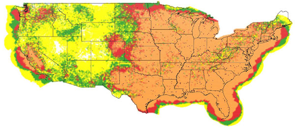
Full-power UHF TV stations in view in the continental United States: yellow (1—3 stations), green (4—6), red (7—10), orange (11 or more). (Image: NAB)
Over the years, we have seen several proposals to use television broadcasts for positioning, navigation, and timing (PNT). This idea was taken one step further in a paper by the staff of the National Association of Broadcasters (NAB). We talked with one of the authors, Robert Weller, NAB’s vice president for spectrum policy, to find out more.
Goward. Bob, your paper calls the notional system the “Broadcast Positioning System” or “BPS.” What is new about your proposal? And what led you and your colleagues to develop this idea and publish the paper?
Weller. Television broadcasters are transitioning to a new transmission standard, ATSC 3.0, that plays well with other industry protocols, has more robust operating points, stricter timing requirements, and is much more flexible. There are already more than 50 US markets with a station transmitting ATSC 3.0. Our paper began to analyze PNT in the context of ATSC 3.0 and confirmed that there was a good match. So, the idea of “broadcast positioning” was born.
Goward. In general, how would BPS work?
Weller. TV stations transmit from towers at known fixed locations. A TV station can transmit its precise location (geographic coordinates and antenna elevation) along with a time-stamp. For fixed receivers using the timing service, only one TV signal is required. Receivers would know their location a priori and would simply calculate their distance from the TV station and use that distance to determine the corresponding time that it takes for the signal to travel from the TV transmitting antenna. That time difference is then added to the received time-stamp to determine the present time at the receiver.
Both fixed and mobile users could access positioning and timing services when at least three TV stations are within range.
Goward. GPS and other GNSS are ubiquitous. What advantages do you see BPS having over space-based navigation systems?
Weller. BPS is not intended to replace GPS. BPS can provide an independent timing and/or position determination, which can provide confidence and help detect spoofing or other problems with GPS. BPS also has the advantage of high power and strong signal levels. Most UHF television stations radiate 1 megawatt of power, which does a good job penetrating buildings and is difficult to jam or spoof.
Goward. There have been many proposals for terrestrial systems to complement GPS. In general, what advantages would implementing BPS have over other non-space approaches?
Weller. There are several advantages. The cost to deploy will be less since the broadcast infrastructure is already in place. Also, because of our high power, the number of nodes necessary is fairly small. I’ll add that TV stations are built to operate 24/7, so most of them are fairly “hard” with back-up power and redundant transmitters. Additionally, the modulation and coding we propose for BPS is intended to provide service well above the noise floor, making it quite robust. Finally, low-cost receivers that are used in televisions can be used to decode the BPS information.
Goward. Your paper says that using the television stations we have today, geographically about 85% of the contiguous United States by land area would be able to get PNT services from BPS. The number is 99% for just timing services. Do you have any thoughts about those not in range for services?
Weller. Those percentages were intended to be conservative and only considered full-power UHF TV stations. There are also hundreds of VHF stations and thousands of low-power TV stations. If you include those stations, the coverage percentages are even higher. It’s certainly possible to add more stations if needed to reach the most remote and unpopulated parts of the United States.
Goward. What about user equipment? Have you done any work in that area? How small do you think receivers could be eventually?
Weller. There are compact GPS and Loran receivers out there, and the technology for BPS isn’t much different. Some Korean companies have already built very small ATSC 3.0 receivers to carry RTK corrections to GPS for use in drones. There are also already ATSC 3.0 USB receivers that weigh less than an ounce.
Goward. Are there other services that BPS could provide?
Weller. BPS can be one element of a PNT system-of-systems that also improves other PNT services. In my opinion, the most valuable service BPS can provide is an alternative reference for critical infrastructure if GPS is compromised. However, BPS would occupy a tiny fraction of ATSC 3.0 signal capacity. So, there could be additional services such as transmitting ephemeris data for expedited GPS acquisition, RTK data for improved PNT accuracy, or even map information.
Goward. Have you thought about what you would be using as a time source?
Weller. Most TV stations already have GPS, but since the point of BPS is to provide redundancy and resilience to GPS, we’re looking at cesium clocks, optical fiber, and eLoran as possibilities.
Goward. NAB is a trade association. How do you see this project benefiting your members?
Weller. This project affirms the public service mission of broadcasters as well as our designation as critical infrastructure. If broadcasters are compensated for the equipment and resources required for deploying and operating BPS as a public service, I expect high participation and user adoption.
Goward. Where do you think you and your colleagues will take the project from here?
Weller. We’re working with possible users to determine their requirements while also trying to identify funding sources to enable the development. We hope to build prototypes and launch market trials as next steps towards commercialization.
By Nino De Falcis, Senior Director of Business Development, ADVA
Today’s critical network infrastructure is heavily reliant on positioning, navigation and timing (PNT) services. Power grids, financial markets, transportation, data centers, communications — all have become more complex and interconnected, while the threats to the PNT on which they depend have grown in frequency and sophistication. PNT systems are so vulnerable to the activities of cybercriminals that attacks may soon become global in scale and significance, with potential costs of billions of dollars.
Utilities are a key example of infrastructure at risk. In the past, power networks were passive systems with everything simple and centralized, and with energy flowing in one direction only as AC power was provided to consumers. However, the growth in renewables and distributed energy resources has spurred diversification of the market, and a new paradigm of bidirectional AD and DC energy production and distribution has emerged: the smart grid.
Timing Challenges
Today, many smaller producers are generating power from multiple sources. The power grid has become a decentralized system and the flow of energy is now bidirectional. Energy from solar panels (microgrids), for example, can be generated by private individuals and either stored or fed back into the grid. Electric vehicles (EVs) are also becoming more common, and like all other nodes across the smart grid, charging points require precise timestamping of the massive amount of data they generate to balance power demand and supply.
Precise timing is also key to rerouting power flows away from transmission outages, to locating power line faults, and for synchronizing distributed control and protection systems. Without highly accurate timing and synchronization, power grids are vulnerable to partial outages and even complete blackouts.
That is why accuracy requirements of data timestamping are tighter than ever. In fact, they are shifting from legacy Network Timing Protocol (NTP) timestamping, which has millisecond accuracy needs, to Precision Timing Protocol (PTP) timestamping, requiring sub-microsecond accuracy. The syncrophaser now demands accuracy better than 1 microsecond.
For fault location, we’re now at 100 nanoseconds. The micro-phasor measurement unit (PMU) is at less than 1 microsecond and substation LAN communication protocols have to be time-stamped at as low as 100 microseconds for GOOSE IEC 61850 and at 1 microsecond for IEC 61850 sample values. This is a big change from just five years ago when accuracy in all these categories was firmly in the millisecond range, and it’s a high bar that needs to be maintained by next-generation redundant systems, should GPS or ground-based timing become compromised.
Guidelines for making PNT infrastructure fully redundant are being pushed by governments across the world. In the United States, regulations are being driven by Executive Order 13905 with the Department of Homeland Security (DHS) providing a framework for how assured PNT (aPNT) should operate. It states that PNT infrastructure must perform three core functions: prevent, respond and recover. Infrastructure must have the ability to prevent atypical PNT errors and corruption of PNT sources. If prevention fails, networks must be able to respond to detected errors or anomalies and then recover from those errors.
The DHS framework outlines four resiliency levels. Level 1 has only one source providing PNT, while level 4 is a next-generation system leveraging multiple sources to derive and distribute PNT data. At Level 4, systems need to be self-survivable. This means they must function for long periods in the absence of a GPS timing source, or when ground-based timing sources have been otherwise compromised. There is even an IEEE P1952 resilient PNT standard in progress that will use this DHS framework.
Rising Threats
There are two categories of threat to PNT: external and internal. External threats include jamming (equipment that can block GPS is available off the shelf for as little as $20) and spoofing, which is the act of transmitting false GPS signals that trick receivers into calculating an erroneous position. Sophisticated cyberattacks can be in the form of either of these and spoofing (especially synchronous) is the most complex to detect.
The two main internal PNT threats come from attacks on NTP and PTP network timing as well as active GPS receivers connected to the network.
Legacy power grids have traditionally used NTP to distribute timing to substations, including IRIG, and this has already shown itself to be vulnerable to attack because it can be hacked by a process called NTP amplification.
Today, power grids are increasingly migrating to PTP because it provides the sub-microsecond accuracy needed for modern applications. PTP also has not yet been hacked, but that does not mean it soon will not be. If an attack did occur on ill-prepared critical infrastructure, the results could be catastrophic.
Secure Smart Grid Timing Components
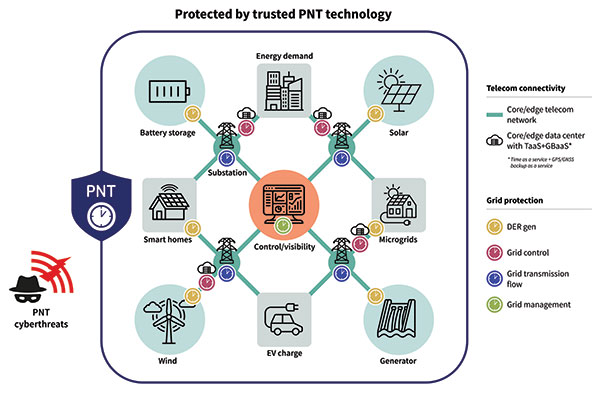
There are two components in the smart grid: telecom connectivity to transport data, and grid protection that has different level generation grid control, transmission and management. On the telecom side, there is the edge telecom network and sometimes there are data centers. There are either core or edge data centers and these are also equipped with very good timing. A key concept in the data center is time as a service and GPS backup as a service when GPS goes down. The smart grid can also leverage this service as it gives even more robust protection and security against threats to PNT. See Diagram 1.
Diagram 1. A key concept in the data center is time as a service. (Image: ADVA)
A Resilient and Assured PNT Solution
As with other aspects of cybersecurity strategy, smart grids must employ a zero-trust framework of PNT sources. This approach never assumes that any one PNT source can be trusted. Instead, it uses a multi-source approach, verifying sources and comparing them to each other in real time to get the most accurate timing possible.
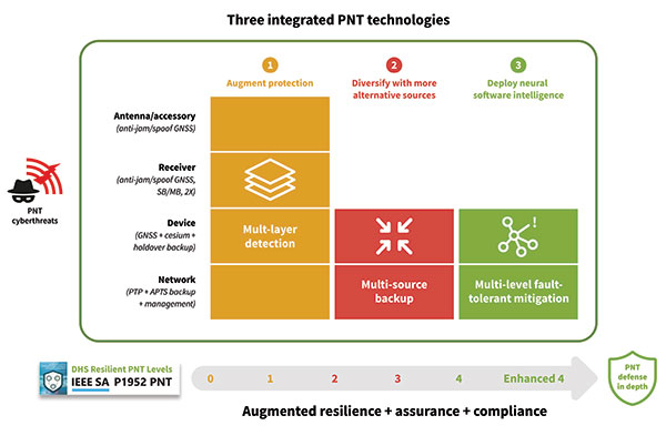
To prevent and mitigate interruptions to GPS, smart grid operators should deploy a resilient and assured PNT solution. This means it’s based around three integrated technologies: multi-layer detection, multi-source backup and multi-level fault-tolerant mitigation.
Multi-layer detection is performed through timing devices – either single or redundant – that have jamming and spoofing detection and monitoring capabilities. GNSS devices are also capable of comparing sources such as network PTP timing and they can be equipped with standalone, GNSS-backup clocks that leverage rubidium or cesium oscillators to obtain the most reliable timing information from other timing sources in the network.
Multi-source backup comes in the form of a cesium or rubidium oscillator that can provide extended holdover. Backup can be further bolstered with other sources such as eLORAN, NIST and LEO.
A neural network management system is an intelligent platform that ties everything together, from self-actionable recovery and assurance software to alerting users of issues in the network-wide timing infrastructure. It provides visibility and control of all aspects of prevention, mitigation and backup. The management system gives detailed operational data on the smart grid, showing the locations of the faults, the types of faults, and how PTP backup assurance is performing. Through capabilities powered by artificial intelligence and machine learning, the management and control system provides the end-to-end control, visibility, and trusted, assured PNT. It has all the intelligence to reveal threats and also take action against them, quickly recovering the network’s timing distribution capability, while keeping the network timing self-survivable. See Diagram 2.
Mitigating Cyberattacks with a Defense-in-Depth Approach
So, let us imagine there is a major attack on a smart grid. A jamming device has been used to block GPS reception on an edge grandmaster being used at a substation, while at the core of the network an ePRTC’s ability to receive GNSS signals has also been compromised. GPS is no longer viable as a source for timing in the smart grid.
The intelligent software monitoring and management system is the first line of defense, detecting and alerting operators to the two or more attacks on GPS: one at the core of the network and one at the substation. The network timing capability of the whole smart grid has been compromised.
Upstream from the substation, the core enhanced PRTC (ePRTC) has become an unreliable source of timing. However, it is equipped with a cesium clock that steps in to propagate trusted PNT backup into the substation and throughout the rest of the network. The cesium clock has no antenna, no RH signal, and is a stratum 1 clock that can propagate highly accurate timing (accurate to 1 microsecond over four months) throughout the network. It has now become the trusted source of timing until GPS can be re-established.
The most crucial element of PNT is timing. Without timing there is no positioning or navigation — it is the enabler of both — and so the distribution of accurate timing must be our top concern when we build systems.
For smart grids and all other critical infrastructure dependent on PNT to function, the cornerstone for secure and self-survivable timing networks is the concept of zero-trust. A multi-source approach to building timing networks will allow operators of critical infrastructure to leverage a combination of intelligent management software and timing devices equipped with adequate PTP holdover to respond to all threats to PNT.
To see a real-world example of this approach in action, check out the DOE DarkNet program.
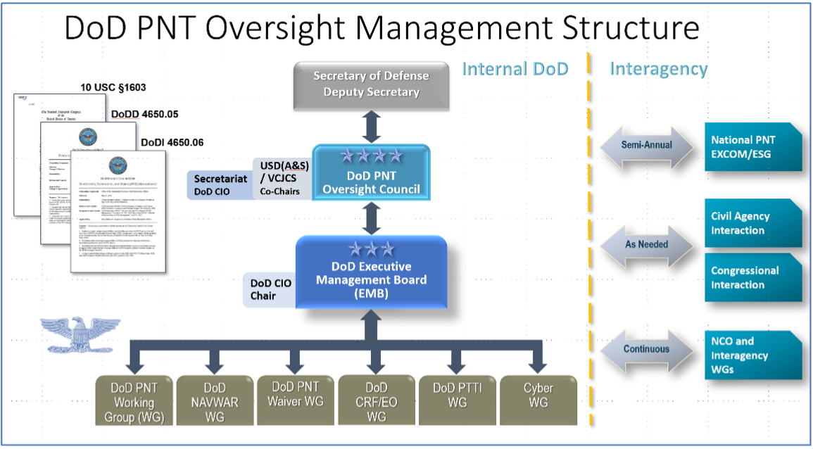
In early August, the U.S. Government Accountability Office (GAO) released its third report in 15 months about GPS and other positioning, navigation and timing (PNT) issues within the Department of Defense (DOD). Each report raised raised concerns about the way in which PNT programs were being managed and led within the department.
Observations included that DOD continues to rely heavily on GPS despite known vulnerabilities. Also, that alternate PNT efforts are not well coordinated and receive little support.
“Opportunities” for DOD to improve its alternate PNT efforts, according to the report, include:
Improving coordination across the services
Clarifying authorities and responsibilities for prioritizing needs
Focusing on resiliency versus GPS as the cornerstone of department PNT efforts
Clarifying PNT requirements rather than just defaulting to GPS as “the need”
The report pointed out that M-code has been in development for 20+ years, and that GPS satellites have been capable of transmitting M-code signals since 2005. Also, while there are still program risks, the Next Generation Ground Control Segment, known as OCX, is forecast to be ready to support M-code use by 2023.
OCX has experienced severe cost overruns and is more than five years behind its original schedule. GAO issued a report on OCX delays in May 2019.
M-code won’t really be a capability in DOD, though, until user equipment is widely fielded. That will take several more years, according to GAO.
One of the remaining challenges to M-code implementation, GAO said, was that the department did not collect and validate all the data it needed for leadership planning and prioritization.
A summary on the first page of the report contains what could be seen as harsh criticism of how PNT efforts are led within DOD:
“DOD’s overall PNT portfolio is managed by the PNT Oversight Council, a statutorily established senior-level body. However, the Council has largely prioritized modernizing the existing GPS system over alternative PNT efforts during recent meetings and has no strategic objectives or metrics to measure progress on the alternative efforts.”
Image: DOD
Too Much Leadership?
Some believe the real problem with DOD PNT is not a lack of leadership, but rather too much.
“If everyone is in charge, no one is,” commented one retired senior military officer familiar with the issue.
“Congress has been concerned about DOD’s lack of attention to GPS and PNT alternatives for years,” the individual said. “In 2015 Congress mandated creation of the Oversight Council to help ensure PNT got the right amount of leadership attention.” This may have not had the desired effect, though.
“The council is comprised of three undersecretaries, the vice chairman [of the Joint Chiefs of Staff], four combatant commanders, the NSA [National Security Agency] director, DOD’s CIO [chief information officer], and host of other very senior folks. All of whom have way too many other duties. It’s no wonder the department has a hard time getting things done!”
The department’s CIO is the Defense Secretary’s Principal Staff Assistant for PNT. As such, the CIO is tasked with coordinating department-wide efforts. The task is made particularly difficult by the many and diverse players across the department, all of whom have their own authorities, interests and projects.
Proposed systems and capabilities are examined and developed by a variety of DOD organizations. These include laboratories belonging to the five services and the Defense Advanced Research Projects Agency (DARPA).
Programs of Record, which usually lead to acquisition of large systems, are led and managed within the individual services.
A Better Way?
Aside from recommending improved coordination of PNT efforts across the department, GAO has never addressed the way DOD manages its PNT enterprise.
“That is not something we normally get into unless specifically tasked,” said one of the reports’ authors. “We assume departments know best how to lead and manage their efforts.”
Others are not so reticent. They believe the current management structure is incapable of managing the development, acquisition and fielding of the DOD PNT Enterprise with any urgency or efficiency.
“GAO’s focus on the Oversight Council is misplaced,” one retired official asserted. “The missing piece is not oversight, it’s day-to-day DOD-wide management.”
“They need a multi-service program of record for resilient PNT,” the official said. “This would be separate from the GPS program, which would keep its own projects going and feed into the resilient effort. The new resilient PNT program should be managed by a Joint Program Office, which could consolidate integration and acquisition of resilient PNT applications. The office would be the steward for the critical technologies that underpin the modular, open-system integration strategy, including the digital reference architecture, input and output standards, software fusion engines, and needed modeling and simulation tools to ensure NAVWAR compliance.”
Such a construct could provide needed focus and coordination to DOD efforts, address many long-standing congressional concerns, and, by coordinating efforts within DOD and with industry, accelerate progress.
Dana A. Goward is President of the Resilient Navigation and Timing Foundation. He serves on the President’s National Space-based Positioning, Navigation, and Timing Advisory Board.
On July 14, the U.S. House passed its version of the National Defense Authorization Act (NDAA) for fiscal year 2023, which begins Oct. 1, 2022.
The report released with the legislation contains several provisions of interest for the GPS and positioning, navigation and timing (PNT) communities. Perhaps most intriguingly, it indicates the National Guard is considering a program to ensure it has one or more sources of time independent from GPS.
Here are some of the more interesting PNT-related mentions in the report.
GPS Disruption & RF-Based Alternatives
A provision entitled “Briefing on Disruption of Global Positioning System” reiterates concerns Congress has expressed repeatedly over the last two decades.
On the civil side, these concerns have resulted in prohibiting the U.S. Coast Guard from disposing of old Loran facilities until a backup for GPS is decided upon and requiring the Department of Transportation to establish a timing alternative to GPS.
Most of Congress’ attention has been focused on the Department of Defense (DOD), though. Over the years, it has tasked the department with a wide variety of briefings and actions including reporting on threats to GPS, how DOD will operate in GPS-denied environments, progress (or lack thereof) in OCX and M-code, and development of alternative PNT systems.
The 2021 NDAA took a more activist approach and required DOD to “generate resilient and survivable alternative positioning, navigation and timing signals.” It also directed the department to work with the National Security Council, the departments of Transportation, Homeland Security, and others “to enable civilian and commercial adoption of technologies and capabilities for resilient and survivable alternative positioning, navigation, and timing capabilities to complement” GPS. The act mandated that this all be completed within two years.
Photo: Andrea Izzotti/Shutterstock.com
The 2023 NDAA reinforces Congress’ long standing concerns about “increasing threats of disruption” to GPS, stating “it is critical to invest in technologies that provide resilient and assured positioning, navigation and timing capabilities…”
Language in that same provision, though, focuses just on alternate navigation capabilities as opposed to full PNT. The act requires a briefing before the end of this year about DOD’s plan across the Future Year Defense Program (FYDP) for “alternative navigation broadcast services.” The briefing is required to include information about “progress on radio frequency-based alternative navigation solutions,” what the department is doing now, and cost estimates for infrastructure and other expenses across the FYDP.
Army MAPS Program
The Army’s Mounted Assured PNT System (MAPS) is focused on ground vehicles. Information on the service’s website seems to indicate the upgrade in the first generation of MAPS is an anti-jam antenna. The overall program of record is more ambitious, according to the site, and includes M-code, other GNSS and inertial sensors.
“Path to ALTNAV” and “Open Standards Interfaces” are also listed as features in the MAPS final version. This is likely incorporation of DOD’s mandate for modular open system architecture to ensure the ability to easily integrate future navigation and timing systems and signals.
The Army is already producing and fielding the Gen 1 version of MAPS. In March 2022, the Aberdeen Proving Ground News announced that 1,000 units had been fielded.
In its report accompanying the NDAA, Congress expressed concern with the pace of the MAPS program. It notes the Army has procured 2,000 units — a small fraction of the 225,000 ground vehicles the service operates.
The text of the congressional report also seems to indicate the program is not much beyond the point described on its website two years ago. The website says a Program of Record technical solution was planned to have been finalized in September 2020.
The House version of the bill would require the Army to provide a briefing on:
technical performance of candidate systems to incorporate into MAPS
the cost of these systems and integration
plans to deploy MAPS to the Army’s fleet of vehicles
plans to upgrade the Gen I MAPS units already fielded.
Another indication of the delayed pace of the program is that this briefing is not due for more than a year, in December 2023.
Autonomy Software for PNT-Denied Environments
While much less specific, another interesting PNT-related provision is a requirement for DOD to “Report on autonomy software for Next Generation Air Dominance.”
It describes a developing Air Force strategy for using piloted and unpiloted aircraft alongside each other. The software “could enable the continued operational capability of systems in positioning, navigation and timing-denied environments.” The Navy and Marine Corps are developing a similar concept.
Photo: Brian Kinney/Shutterstock.com
Little public information is available concerning any of the Next Generation Air Dominance programs or supporting systems. Experts have speculated, though, that operation in PNT-denied environments would likely involve some of the aircraft remaining outside the denied area and providing PNT information to the others via one or more links.
National Guard and Nationwide Alternative Timing
At the end of a section entitled “Collaboration on positioning, navigation, and timing research,” the House report reveals that the National Guard is concerned about relying entirely on GPS for timing and seems to have begun to address that shortfall.
It requires a report no later than February 2023 on the Guard’s “Nationwide Integration of Time Resiliency for Operations (NITRO) effort.” The report should address, among other things, mission need, capability gaps, estimated costs and how the department is collaborating with other federal, state and local entities.
The budget item for NITRO cites malicious cyberattacks that can impact command and control (C2) systems. It says the Guard’s ability to support civil authorities and critical infrastructure is at risk if not mitigated with resilient time.
While attempts to reach the National Guard for comment have been unsuccessful, PNT expert Pat Diamond said the Guard’s concerns and efforts are well justified. “Precision timing is a seriously weak link for everyone in the United States, including critical infrastructure and organizations like the National Guard,” Diamond said. “If GPS timing was not available for some reason, land mobile radios, common operational pictures, the ability to navigate, plus command-and-control systems would suffer greatly, potentially being completely degraded. It’s outstanding that the Guard has realized this and seems to be moving out. All the power to them.”
A Must-Pass Bill
The House version of the 2023 NDAA has yet to be conferenced and reconciled with that of the Senate. While the Senate’s version of the NDAA has been filed, the accompanying report has not yet been released. Since the House provisions seem relatively non-controversial, they are almost certain to be included along with others from the Senate in the final bill and report.
The resulting legislation is almost certain to pass into law.
Congress often struggles to pass even routine legislation. For example, it has only funded the government on time in four of the last 40 years. The annual defense authorization is an exception. NDAA’s are considered “must-pass” bills. Congress has sent one to the president in each of the last 61 years.
Dana A. Goward is President of the Resilient Navigation and Timing Foundation. He is also a member of the President’s National Space-based Positioning, Navigation, and Timing Advisory Board.
ADVA is enabling service providers to offer GPS/GNSS-backup-as-a-service (GBaaS) to answer the need for operators to safeguard services that rely on positioning, navigation and timing (PNT) information.
Along with spoofing and jamming of GNSS, in-network timing based on network time protocols (NTP) and precision time protocols (PTP) are also increasingly vulnerable to cyber threats.
As a response, ADVA is now empowering service providers to offer GBaaS and enable end users to address new guidelines and standards for redundant PNT architectures. GBaaS meets the latest recommendations for PNT homeland security, including U.S Executive Order 13905. Leveraging ADVA’s aPNT+ technology, GBaaS eliminates the risks and costs associated with GNSS dependence.
“Threats to hamper PNT capabilities are growing, and much of the world’s critical infrastructure is still without adequate protection from GNSS vulnerabilities,” said Gil Biran, general manager of Oscilloquartz, ADVA. “All of that can change when service providers are able to offer GBaaS.”
GBaas is based on ADVA’s aPNT+ platform, which leverages a suite of technologies, including multi-band GNSS receivers and management software based on artificial intelligence and machine-learning.
Service providers can offer ADVA’s aPNT+ protection as a subscription-based service as part of their service-level agreements.
ADVA’s GBaaS solution employs a combination of multi-layer detection, multi-source backup and fault-tolerant mitigation to render timing networks more secure. Embedded in all timing devices, ADVA’s Syncjack technology provides comprehensive and precise synchronization performance monitoring and analytics, enabling the Ensemble Sync Director network management suite to intelligently operate and prioritize multi-source timing feeds across the network.
Onboard multi-band GNSS receivers boost timing accuracy and also protect against attacks like jamming and spoofing. When GNSS is either unavailable or compromised, a dispersed network of autonomous cesium atomic clocks and network backup timing feeds is ready to deliver highly accurate network timing over long periods of GNSS unavailability.
Artist’s impression of the CACI/York Space DemoSat scheduled to launch in January 2023. (Credit: CACI)
CACI International, a U.S. defense contractor, plans to demonstrate a supporting navigation technology for military use as part of its DemoSat launch in January 2023.
CACI will launch two demonstration payloads on a York Space Systems satellite scheduled to fly to low Earth orbit in January aboard the SpaceX Transporter 7 rideshare.
The payload will contain an alternative positioning, navigation and timing solution that will work in a contested space domain. It is designed to support rather than replace GPS.
The technology is two-way time transfer and clock modeling technology. Two-way time transfer has been used for years on the ground, but in this case will be used in space. The low size, weight and power (SWaP) space-based PNT is expected to significantly improve multi-platform remote sensing.
If the experiment is successful, CACI plans to offer the two-way time transfer PNT service to the military and other government agencies.
CACI has completed the critical design review for the DemoSat. CACI and its partner York Space Systems will also demonstrate a tactical intelligence, surveillance and reconnaissance (TacISR) payload. The TacISR payload identifies and captures key signals of interest and operates with CACI’s Beast ground receiver to demonstrate real-time radiofrequency geolocation for deployed U.S. forces.
“CACI expertise, systems, and technology help our customers maintain dominance in the increasingly contested space environment,” said Mike Hale, executive vice president of CACI’s Advanced Solutions Group. “We are very proud that CACI is launching a DemoSat payload into orbit – distinguishing our mission technology and transformative solutions for customer success.”