Tag: DARPA

  • UAV updates: DARPA advances UAVs, Area-51 RQ-170 investigation expands and more

    UAV updates: DARPA advances UAVs, Area-51 RQ-170 investigation expands and more

    Most people appear to be silently waiting for artificial intelligence (AI) to come up with a meaningful application beyond replicating jobs — one that actually helps people accomplish new tasks.

    Daily news reports show one of the so-called “Magnificent Seven” technology companies pouring another billion dollars or more into AI data centers or basic development. Well now, the Defense Advanced Research Projects Agency (DARPA) has found a smaller AI company to develop a novel application for UAVs.

    VISTA X-62A autonomous aircraft (Photo: Alex Lloyd/USAir Force)
    VISTA X-62A autonomous aircraft (Photo: Alex Lloyd/U.S. Air Force)

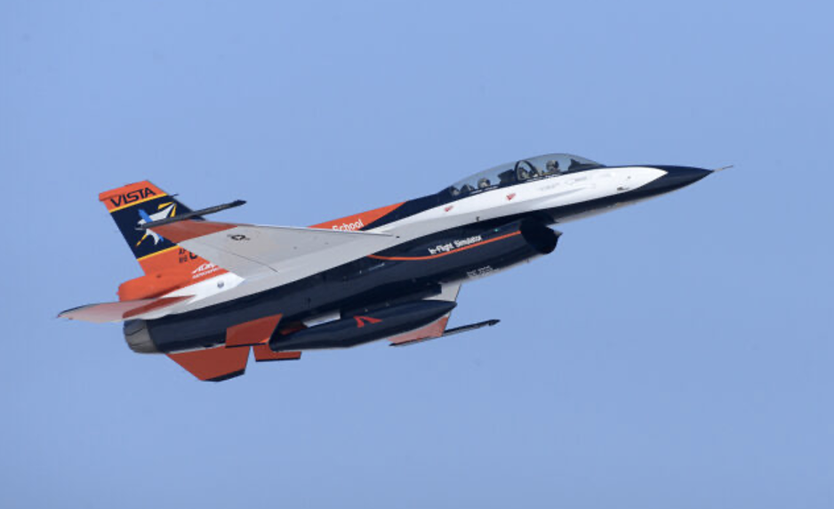
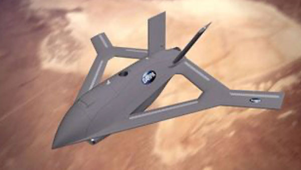
    PhysicsAI has contributed AI “agents” to a highly modified F-16 for machine perception, intelligent behavior, control and adaptive learning to create an autonomous UAV, according to available information. The VISTA X-62A participated in a manned-unmanned dogfighting demonstration in September 2023, though the outcome has not been disclosed. Other platform enhancements include intelligent sensors through computer vision, EO/IR/RADAR sensor fusion and virtual reality simulations.

    DARPA has engaged PhysicsAI to enhance UAVs so they can extend range and mission length by “soaring” — the technique birds use to find thermals in the atmosphere to climb to higher altitudes. AI agents will be designed, trained and tested to evaluate dynamic wind conditions, optimize flight profiles and perform soaring maneuvers.

    DARPA intends to develop AI agents that will extend endurance by employing this bird-like soaring capability to reduce UAV onboard power usage and extend range and mission duration.


    There is nothing new to report on the apparent drone crash Sept. 25, 2025, near the secretive base in Nevada, known as Area 51. The aircraft was attached to the 432nd Wing/432nd Air Expeditionary Wing at Creech Air Force Base in Nevada, about 57 miles southwest of the crash site. The 432nd operates MQ-9 Reaper drones, but the 33rd and 44th Reconnaissance Squadrons are also known to operate out of Creech and may operate RQ-170 Sentinel stealth drones.

    RQ-170 Sentinel Stealth Drone thought to operate out of Cheech AFB Nevada (Photo: Lockheed Martin)
    RQ-170 Sentinel stealth drone thought to operate out of Cheech AFB Nevada (Photo: Lockheed Martin)

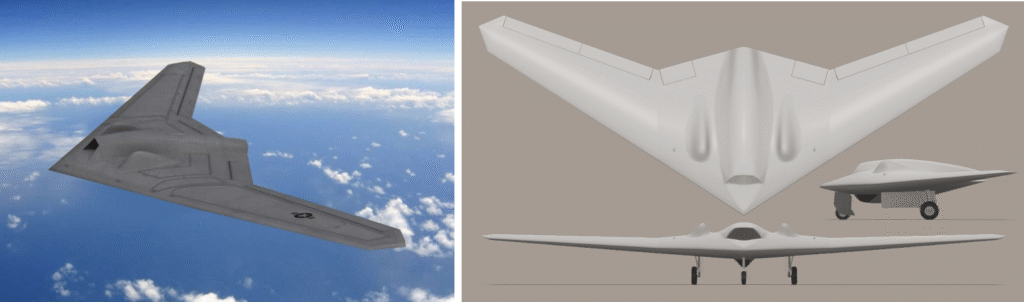
    Famous (or infamous) for a 2023 reconnaissance operations in Iran, where one aircraft was apparently captured by the Iranians, the RQ-170 has been around since 2021.

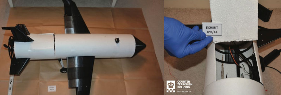
    The mystery surrounding the crash near Area-51 has grown somewhat since an inert training bomb and an aircraft panel were discovered at the crash site, but these items were not part of the damaged/destroyed crashed aircraft. In addition, the Air Force Office of Special Investigations (OSI) and the FBI have now been brought in to investigate. Enthusiasts who managed to get to the crash site recently found it cleaned completely, with no sign of spilt fuel or debris.


    Troops in the field need information most — where the enemy is, their capabilities and what they’re doing.

    One option: Launch a drone with video, infrared and radar, then use whichever works best depending on lighting, weather and whether the enemy jams signals. Better yet, call in a high-altitude surveillance drone like a GA-ASI Reaper that the enemy can’t see or hear. But that takes time, and one might not be available.

    A new concept builds on an old precept — climb a tree and look at the opposition. But trees can be hard to find, difficult to climb and not high enough.

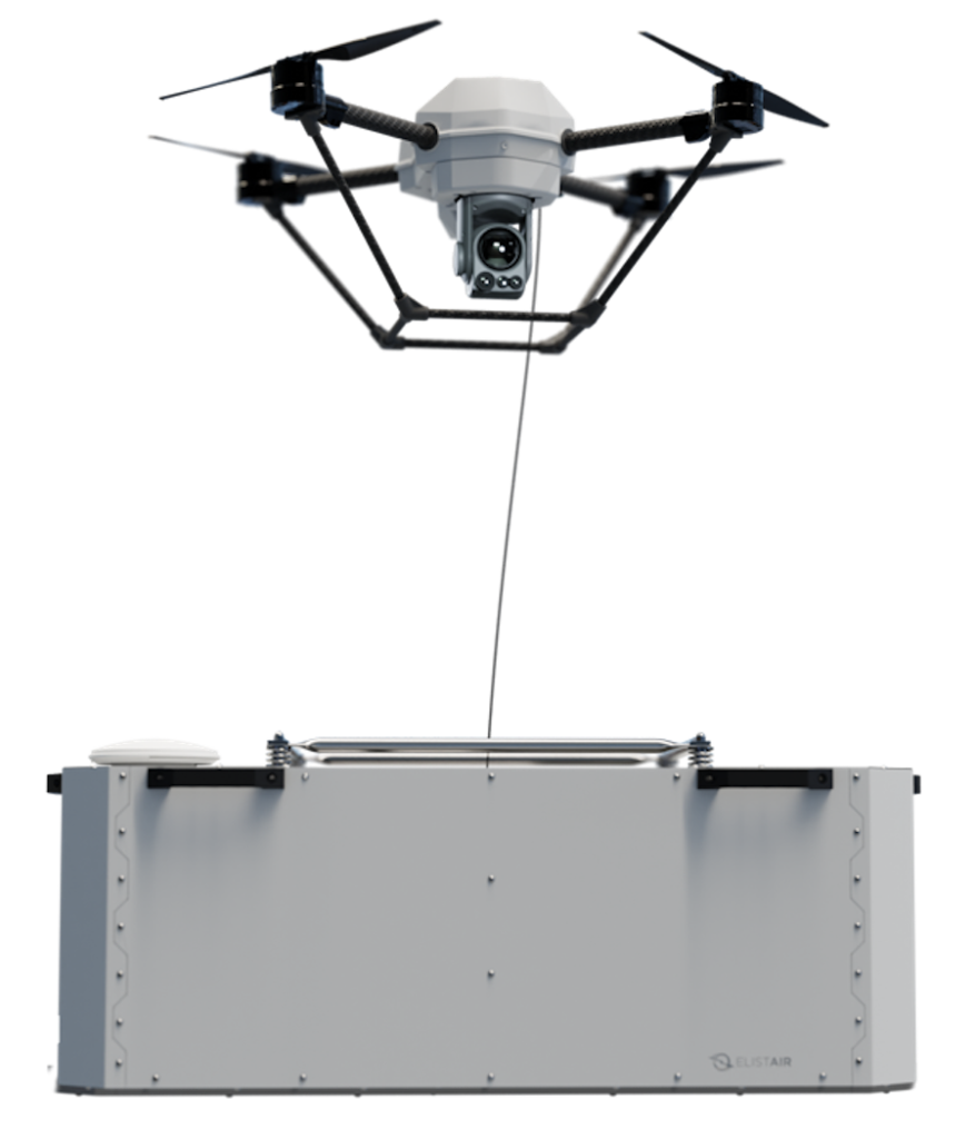
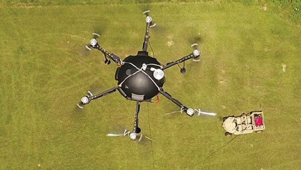
    The answer to jamming and observational altitude: a tethered drone that a squad can carry. If the squad has a truck or Humvee, it can launch a tethered drone with no time limits because power comes up the tether with driving instructions while visual data goes back down. If necessary, move the ground vehicle closer and the drone moves with it.

    Tethered drones serve any operation needing overview — rescue teams in disasters needing to see farther or a temporary communications hub, security operations searching for someone or something, monitoring or observing for infiltrators, initial surveys of difficult-to-access locations or military operations. Many other applications exist.

    Most commercial and first-responder operations favor commercial or heavy-lift multirotor drones. Companies using multirotor drones include Hoverfly, Zenith, Fotokite, USaS, Advexure, Elistair, Kratos and Volarious.

    Elistair Khronos Tethered DroneBox. (Photo: Elistair)
    Elistair Khronos Tethered DroneBox. (Photo: Elistair)
    Kratos Aethon	 Tethered Drone. (Photo: Kratos)
    Kratos Aethon Tethered Drone. (Photo: Kratos)

    If tethering drones to get really high, maybe use an aerostat that TCOM claims can operate from ground level to the stratosphere — pretty long tether needed! But applications also include anti-drone systems used to track and disrupt drone intruders.

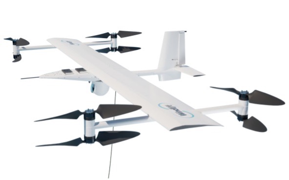
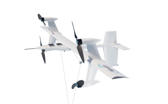
    Then a more recent entrant is Windlift who uses a fixed wing multi-prop drone on the end of a very long tether to gain altitude and to operate in the sort of wind conditions that might be found at times in many locations world-wide, on land or at sea — very windy to gale force winds, actually up to 55mph. Now this is pretty tough for any tether system, but Windlift has a variable cross section tether which mitigates wind-resistance. And their special application is to fly in a figure of eight pattern at high altitude — to generate electricity.

    Windlift surveillance drone(Photo: Windlift)
    Windlift surveillance drone (Photo: Windlift)
    Windlift power generator (Photo: Windlift)
    Windlift power generator (Photo: Windlift)

    This month brings a mixed bag of drone news, ranging from AI-driven “soaring” drones to an Area 51 drone crash mystery and an overview of tethered drones and their applications, including power generation. Who could have forecast these drone applications? Well, maybe the crashing part.

  • Q-CTRL, Lockheed to Develop Quantum Navigation for DARPA

    Q-CTRL, Lockheed to Develop Quantum Navigation for DARPA

    DARPA selects Q-CTRL to develop next-gen sensors for advanced defense platforms.

    Quantum software company Q-CTRL has been awarded two contracts under DARPA’s Robust Quantum Sensors (RoQS) program. The Defense Advanced Research Projects Agency (DARPA) is an independent research and development agency within the U.S. Department of Defense.

    The contracts, valued at $24.4 million, will augment Q-CTRL’s field-validated quantum sensing technologies for demanding real-world use cases in high-performance military vehicles. 

    Navigational technology that is resilient to denial, jamming, spoofing and other denials in the environment has become increasingly critical to defense applications, from battlefield operations to intelligence and surveillance. With conflict zones expanding, the risks to crewed and uncrewed defense missions are growing daily. Quantum sensing offers a complementary solution to  GPS that is resilient against external interference while filling coverage gaps.

    Quantum sensing offers a complementary solution to  GPS that is resilient against external interference while filling coverage gaps.

    Q-CTRL will develop next-generation quantum sensors for navigation based on their success in field trials of airborne, maritime, and ground-based quantum navigation augmented by their proprietary AI-powered software ruggedization. The technology enables sensors to operate reliably on moving defense platforms subject to challenging real-world conditions, without the need for traditional shielding or isolation.

    Q-CTRL will be joined by Lockheed Martin as a subcontractor on one aspect of the RoQS program, leveraging its expertise in GPS and quantum technology.

    Photo:
    Software-ruggedized quantum magnetometer. (Image: Q-CTRL)

    DARPA established RoQS to accelerate the development, testing and validation of quantum sensors for real-world defense applications, which include maintaining stability against environmental interference, mechanical vibrations and heavy g-forces. 

    Some sectors and organizations are fast-maturing quantum navigation for use on land, sea, in space, and in the air. The aerospace industry is actively exploring the potential for magnetic navigation technologies, with companies like aircraft manufacturer Airbus pursuing their development. 

    Additionally, Q-CTRL’s programs target the complementary missions of geophysical mapping of gravity and magnetic fields, as well as positioning based on matching detected signals to the pre-generated maps. This approach provides huge advantages in navigational missions and delivers new insights into minerals prospecting and underground target detection.

    Photo:
    Software-ruggedized quantum gravimeter. (Image: Q-CTRL)

    Ironstone Opal, the company’s quantum-assured navigation system, recently outperformed a high-end inertial navigation system (INS) in flight for the first time, achieving up to 111x greater positioning accuracy when GPS was unavailable – a significant step forward for real-world applications of quantum sensing to defense missions. In these tests, the company’s proprietary AI-driven, software-level innovation was the key to the removal of platform interference.

    Ironstone Opal’s navigation system was also recently validated in maritime trials on board the Royal Australian Naval vessel, MV Sycamore.

    In March, Lockheed Martin and Q-CTRL were awarded a contract by the U.S. Department of Defense’s Innovation Unit to prototype a quantum-enabled inertial navigation system.

  • Kamikazi UAVs and X-Wings

    Kamikazi UAVs and X-Wings

    A UK judge just jailed a student for building a UAV. How could that be? Well, the 3D-printed UAV built by a guy in his room at home was only part of the story. It turns out that his jailing was perhaps more related to his connection to the Islamic State of Iraq and Syria (ISIS), and his apparent intent to use this UAV loaded with explosives or a chemical weapon to attack ISIS enemies.

    3D-printed drone seized by anti-terror officers and rear access panel (Image: West Midlands CTU/PA)
    3D-printed drone seized by anti-terror officers and rear access panel (Image: West Midlands CTU/PA)

    The experts who analyzed the vehicle stated that it was only partially built and appeared somewhat ‘primitive’ in its construction. It would seem that an explosive charge or chemical weapon would need to be located with its fusing circuitry at the front end of the UAV, and maybe the enclosure was rather an access panel to aid the build process.

    It is unclear whether the protruding black item towards the front of the UAV is either a GNSS or communications antenna. This antenna would normally be placed on the upper skin and relatively close to the autopilot or comms radio. It is possible that there is a communications/control signal antenna at the top of the vertical stabilizer. Rudimentary landing gear can be seen aft of the control surfaces of the wing, but the rear propulsion does not appear adequate for the size of the vehicle. Not a bad attempt to create an amateur UAV, but a pretty bad idea for the guy involved to intend it to be a kamikaze, one-way drone for ISIS — he received a 20-year sentence.

    Both Russia and Ukraine continue to churn out new models of one-way UAVs, which they enthusiastically hurl at one another. Russia unveiled a new swarm drone known as ‘Product 53’ which apparently has the ability to seek and identify targets autonomously.

    With a payload of only 3-5 kg it cannot inflict severe damage on major targets, but the plan is apparently to bombard an area with large numbers of Product 53 controlled as a swarm.

    So, Russia’s latest software-driven, sophisticated kamikaze UAV is a far cry from the primitive, partially constructed, 3D-printed UAV which lead a UK court to jail its constructor. Much more was obviously made of his encrypted online contacts with ISIS and his intent to inflict potential death and destruction on behalf of a terrorist group.


    On a far brighter note, a Defense Advanced Research Projects Agency (DARPA) project known as Control of Revolutionary Aircraft with Novel Effectors (CRANE), which first went out to industry for proposals back in 2021, has now moved into Phase 3 build and manufacture following a successful Phase 2 Critical Design Review (CDR).

    Aurora Flight Sciences, a Boeing Company subsidiary, has been authorized to begin building a 7000 lb X-wing manned/unmanned aircraft. The aircraft is intended to prove out a design for aerodynamic control without the use of moving surfaces.

    Illustration of proposed X-Wing aircraft (Image: DARPA)
    Illustration of proposed X-Wing aircraft (Image: DARPA)

    Elevators, flaps, slats and rudders on conventional modern aircraft require significant internal hydraulics and/or cabling and actuators throughout the airframe, which add to the complexity, and potential failure modes, aerodynamic drag and weight. Most current UAVs emulate these flight control systems and use external control surfaces.

    The DARPA X-Wing aircraft may use compressed air jets or even electrical discharges emitted at critical actuation points along its outer surface to ‘gently push’ the aircraft from its existing path through the airstream, which allows the remote pilot to maneuver the aircraft. Known as Active Flow Control (AFC) this technology has been prototyped to one extent or another in recent years, but this DARPA/Aurora project aims to prove the concept.

    For the demonstration aircraft, normal moving control surfaces will be installed and retained. The aircraft will initially be flown using these standard airflow controls to form a baseline for how the aircraft performs. The control surfaces will then be locked down and the aircraft will be flown using AFC, and the performance will be compared to the standard controls baseline.

    Understandably, the earlier phases of the project likely worked through the required control systems for the unique X-wing configuration. Aurora may have been well positioned to provide such flight control systems, autopilot and software from its store of Guidance, Navigation, and Control (GNC) technology — the basis for the operation of autonomous air vehicles.


    Building illicit UAVs intended for terrorism may not be one of the best academic projects to undertake when you’re an ISIS supporter; Russia and Ukraine appear to be in a race to mass produce ever more sophisticated UAVs; and DARPA/Aurora appear to be headed to a relatively heavy prototype air vehicle demonstrating not only X-Wing technology, but also active flight control. Overall, there is a variety of news on UAVs in various configurations and applications.

  • Tiny clock meets big challenges

    Tiny clock meets big challenges

    chip-scale atomic clocks can supplement GNSS receivers to provide accurate and reliable time in GNSS-challenged environments. Photo: Microchip Technology
    Chip-scale atomic clocks can supplement GNSS receivers to provide accurate and reliable time in GNSS-challenged environments. Photo: Microchip Technology

    Accurate and reliable time is just as important as accurate and reliable location for a wide range of military and civilian applications — and GNSS receivers cannot provide either one when they are jammed. For timing, one solution is to supplement GNSS receivers with a miniature atomic clock. We asked Microchip Technology a few questions about their chip-scale atomic clock (CSAC) and Stewart Hampton, the company’s senior product line manager, responded.

    How long was your SA65 CSAC in development before you announced it in August 2021? Typically, how often do you launch a new CSAC?

    CSAC development started in 2001 under a contract from DARPA with Draper and Sandia laboratories. CSAC was first introduced to the commercial marketplace in 2011, and in 2016 we released an improved product design with an operating temperature range of –10 C° to +70 C°. Last year we released our CSAC SA65 with a wider operating temperature range, faster warm-up and improved frequency stability aimed at the defense and industrial marketplace. So, it has been about five years between major CSAC releases, but that may not be indicative of future products because we have also introduced specialized CSAC versions, such as the Low Noise CSAC (LNCSAC) in 2014 and the only commercially available radiation-tolerant CSAC (Space CSAC) in 2018.

    What is the CSAC SA65’s drift rate?

    Its typical drift rate is specified at <9 × 10⁻¹⁰ per month. Another key specification, particularly for many portable military applications, is total sensitivity of frequency to temperature (tempco) over a specified range. For the CSAC SA65, that specification is ±3 × 10⁻¹⁰ over the entire operating temperature range of –40 C° to +80 C °.

    What are a few specific military use cases?

    CSAC is designed into multiple military programs and used in a wide variety of military applications, particularly in GNSS-denied environments — including assured positioning, navigation and timing (APNT) modules, underwater unmanned and autonomous vehicles, software-defined radios, man-portable transceiver-based military communications, vehicle management computers, airborne reconnaissance/UAVs and GNSS-disciplined oscillators. It is also used in command, control, communications, computers, cyber, intelligence, surveillance and reconnaissance (C5ISR). The space CSAC variant is commonly used on low-Earth-orbit space defense payloads supporting such applications as low-latency communications networks, RF geolocation (geointelligence, or GEOINT), optical time transfer, alternative PNT satellites and Earth observation.

  • New APNT in an old box

    New APNT in an old box

    Leonardo DRS’ A-PNT Converged Computer – Embedded & Scalable (AC²ES) adds capabilities to its widely used DDUx. Photo: Leonardo DRS
    Leonardo DRS’ A-PNT Converged Computer – Embedded & Scalable (AC²ES) adds capabilities to its widely used DDUx. Photo: Leonardo DRS

    To help counter attacks that degrade GNSS capability on combat vehicles, Leonardo DRS developed a modified data-distribution unit computer, the DDUx II, with an embedded assured positioning, navigation and timing (APNT) capability the company calls Assured Positioning, Navigation and Timing Converged Computer Embedded & Scalable (AC²ES). It augments standard military GPS PNT sources with technologies such as anti-jam, anti-spoof, M-code receivers, additional RF sources, vehicle infrared (IR) sensor vision navigation, wheel rotation and inertial measurement units (IMUs). It also offers a choice of multiple timing holdup modules that increase accuracy proportionately with cost.

    The DDUx II and military variants, fielded by the U.S. Army and Marine Corps, allow for integration of APNT functionality with the Battle Management System (BMS). It can provide APNT distribution to all other devices needing PNT within the vehicle without adding to its size, weight and power (SWAP).

    Following a five-year development program, Leonardo DRS launched the AC²ES in September 2021 as a commercial option while continuing discussions with the U.S. Army and Marine Corps, which have not yet adopted it. “We have tested it,” said Mike Stucki, business development manager for the company’s land electronics division. “We have gone to Army jamming and testing events. We have performance and results. However, it has not been officially tested under the Army or Marines programs, with which we are moving forward this year.”

    Leonardo DRS wants to offer the armed services the additional components they need to achieve APNT “and not require them to buy anything they don’t need or want,” Stucki said. Those additional components include multiple GNSS receivers for timing and a low-end internal IMU to provide continuous navigation in case GNSS is disrupted. All these components fit directly into the existing DRS hardware. Under the Mounted Family of Computer Systems (MFoCS) program alone, the Army has fielded more than 100,000 DDUx units. Some vehicles already have high-end INS, wheel encoders, and other sensors, and MFoCS can ingest their data.

    Navigating with Infrared

    For vision navigation, Leonardo DRS uses software developed by its partner Leidos that ingests data from existing hardware on the vehicles, many of which already have IR cameras. In a GNSS-denied environment, this enables the system to navigate by matching what the IR camera sees to an imagery database. Leidos’ software is based on work it began in 2011 with the DARPA All-Source Positioning and Navigation (ASPN) program.

    “Leidos developed algorithms that use these other sensor inputs in the sensor-fusion engine to provide more accurate absolute positioning in a completely RF-denied environment,” said Kevin Betts, PNT director for Leidos. “We take the live images from the vehicle’s existing IR camera and match them to a satellite-derived model of the environment. When the images match, we have an absolute position update that we can provide to the navigation filter.”

    MFoCS “is the heart that runs the Blue Force tracker system that the soldiers use,” said Bart Blanchard, director of advanced programs at Leonardo DRS. “We’ve added the APNT components inside that box. They’re leveraging the hardware that they already own. It’s a very cost-effective solution.”

  • Raytheon swarm enables one operator to guide 100+ drones

    Raytheon swarm enables one operator to guide 100+ drones

    Raytheon BBN-led team recently supported DARPA's fifth OFFSET program field exercise. (Photo: Raytheon)
    Raytheon BBN-led team recently supported DARPA’s fifth OFFSET program field exercise. (Photo: Raytheon)

    Raytheon Intelligence & Space, a Raytheon Technologies business, recently supported the fifth OFFensive Swarm-Enabled Tactics (OFFSET) DARPA program field exercise.

    Using integrated swarm technology developed by a Raytheon BBN-led team, a single operator successfully controlled a swarm — composed of 130 physical drone platforms and 30 simulated drone platforms — both indoors and outdoors in an urban setting. Raytheon BBN provides advanced technology research and development with a focus on national security priorities.

    During the exercise, the team used a combination of commercial off-the-shelf and custom-built hardware and software to deliver swarm autonomy. This enabled a single or small group of operators to direct and manage the activities of a large swarm of autonomous air and ground vehicles with minimal training.

    “Controlling a drone swarm changes the way an operator or group of operators think about the drones,” said Shane Clark, Raytheon BBN OFFSET principal investigator. “Takeaways from this exercise help inform us of the inflection points between utility and manageability.”

    Inexpensive Hardware

    A key element of the program is the use of inexpensive hardware. Without the powerful computing and sensing capabilities available in larger more expensive platforms, Raytheon BBN needed to create a broad library of simple tactic building blocks used to create plans to accomplish mission objectives.

    Raytheon BBN also designed and configured a scalable, modular and decentralized approach to manage a variety of current and future platforms and missions. Whenever possible, the drones collaborate actively to decide how to accomplish a specific mission most efficiently.

    “Our software is smart enough to assign drones with the right capabilities to the appropriate set of tasks,” Clark said. “For example, if the task is to surveil a building, multiple drones will be dispatched, with each surveilling portions of the building. The software considers each platform’s sensor capabilities, and tasks drones with downward-facing cameras to surveil the roof.”

    Once the drones are deployed, their collaboration allows them to understand what parts of a building have been explored and where the gaps are. They then autonomously select how to fill in those gaps.

    Virtual Reality Interface

    To tackle the complexities of human swarm interfaces, the Raytheon BBN team created a virtual reality interface in addition to traditional camera views. It takes feeds from all the swarm assets to create an interactive virtual view of the environment.

    “You can look behind the building to access a view of drone locations, for example, and use the virtual reality environment to test and see if your mission is viable,” Clark said. “We also developed a speech interface with the operationally deployed Tactical Assault Kit, or TAK, integration capability that enables the operator to act quickly while maintaining situational awareness over many systems simultaneously.”

    The Raytheon BBN-led team includes Smart Information Flow Technologies, or SIFT, and Oregon State University. The team is contracted by DARPA to demonstrate its swarm capabilities during Army Expeditionary Warrior Experiment 2022 taking place in February to March, and hosted by the Army Maneuver Battle Lab.

  • Catching DARPA’s gremlins and flying a Renault 4L

    Catching DARPA’s gremlins and flying a Renault 4L

    Developments in the autonomous space this month include an cargo aircraft with unmanned passengers, another way drones can deliver really heavy cargo, and a fanciful recreation of a beloved vintage car.

    How do you catch a gremlin? Wait, what’s a gremlin?

    Gremlins are supposed to be unmanned aircraft which are launched and recovered in flight from a cargo or bomb-carrying aircraft. Flying in small collaborating swarms, gremlins are equipped with sensors for communications, jamming, reconnaissance or other needs.

    As envisioned by the U.S. Army’s Defense Advanced Research Projects Agency (DARPA), gremlins are reusable, may be autonomous, can operate in GNSS-denied environments, and can be flown on high-risk missions into high-risk areas — places that high-value manned aircraft would avoid.

    DARPA has contracted Dynetics to come up with a system that meets those criteria — a pretty demanding list of capabilities. So far, prototype X-61A UAVs have been built and flown through four flight test campaigns.

    Many military technologists have dreamed of unmanned flying aircraft carriers, which could be put to a variety of uses. If the gremlin system works, the commercial world might well find its own applications.

    Carried under the wings of a C-130A cargo transport, gremlins have been launched and flown through three flight tests. Capture and recovery has been attempted but was unsuccessful because of unanticipated turbulence. One  test vehicle was lost when its parachute recovery system failed — altogether, three vehicles have been lost.

    Finally, on Oct. 25 over the Dugway Proving Ground in Utah, one Gremlin X-61A was flown onto the C-130A capture system and successfully recovered.

    The gremlin X-61A test vehicle is recovered into C-130 transport on its fourth test flight. (Photo: DARPA)
    The gremlin X-61A test vehicle is recovered into C-130 transport on its fourth test flight. (Photo: DARPA)

    The DARPA program requires a number of Gremlin UAVs to be captured, recovered and stowed in the mother aircraft within 30 minutes. The current recovery system is somewhat complex, so it remains to be seen if subsequent tests can achieve this substantial goal. Recovery might become easier and more reliable with an increase in the degree of autonomous operation for both the UAV and the recovery system.

    A Guided Box for Disaster Relief

    We turn now from a complex system to a direct and simple one that fulfills a key logistical requirement for disaster relief. It’s a fully autonomous UAV that lacks any integrated power source. Essentially, it’s a guided box.

    The AVIUS Air Delivery Mercy-2000 by Yates Electrospace Corp. is basically an air-dropped cargo container that can glide from an altitude of 25,000 feet to a fixed location. From up to 35 miles away, this precision-guided drone can land safely within 110 yards of the desired site and deliver more than 1,600 pounds of material for critical medical and humanitarian needs.

    Initially developed for military air-drop purposes (the U.S. Air Force just ordered 15), the cargo container is an 8-foot-long box with two sets of folded wings, fitted with a small nose-cone and a larger tail-cone before launch that help stabilize flight. The wings are carried inside the box and are installed by simply turning over the top cover.

    Photo: Yates Electrospace Corp
    Photo: Yates Electrospace Corp.

    The assembly includes the essential guidance system. A COTS (commercial-off-the shelf) GPS receiver, lidar, magnetic heading sensor, barometric altimeter, inertial measurement unit and pitot speed sensor are integrated into proprietary software running on a COTS computer.

    Anyone who has ever tried to land a glider from 25,000 feet knows that actually landing safely in the right place is tough to do. It’s quite an achievement to create a reliable, precision, autonomous solution that works when pushed out the back of an aircraft.

    New Model of Old Renault Takes Flight

    Now to a more fanciful story about an old friend – the Renault 4L.  Many of us remember driving or riding in one, with its gear-change on the dash, uncomfortable seats, suspension and “sewing machine” engine.

    The Renault 4L was manufactured from 1974 to 1978. (Photo: ribeiroantonio/iStock Editorial/Getty Images Plus/Getty Images)
    The Renault 4L was manufactured from 1974 to 1978. (Photo: ribeiroantonio/iStock Editorial/Getty Images Plus/Getty Images)

    In celebration of its 60th anniversary, Renault (now part of the Renault–Nissan–Mitsubishi Alliance) and TheArsenale have teamed up in France to make a flying 4L known as the AIR4.

    The body shell has been re-engineered in carbon fiber with the same shape of the original 4L. The frame has been built for vertical and horizontal flight, with propellers at each corner of the vehicle. The body shell lifts at the front for pilot access. The Air4 carries lithium polymer batteries, providing up to 90,000 mAh. It can achieve 58 mph when tilted forward at 45°.

    The Air4 will go on public display until the end of the year in the center of Paris at the Renault Center on the Champs Elysées, along with other antique models of the Renault 4. Miami will be the next stop for the AIR4, followed by New York and then Macau, China.

    To sum up, we have gremlins making progress and being recaptured, a 1-ton flying box  for important deliveries, and a celebration of 60 years of the Renault 4L — quite a wide range of ingenious unmanned vehicle applications.

    Tony Murfin
    GNSS Aerospace

  • UAVs, walking robots and an autonomous tugboat

    UAVs, walking robots and an autonomous tugboat

    In a slight expansion from our previous monthly UAV newsletter columns, we’re now looking at autonomous systems with a wider outlook, capturing the automated world as it evolves.

    The Eve air taxi. (Image: EmbraerX)
    The Eve air taxi. (Image: EmbraerX)

    News this month covers steps toward air taxi qualification, highly challenging underground UAV and robotic capers, and long-distance watercraft autonomy in Denmark.

    EVE gets order boost by Bristow

    We’ll soon be seeing them — electric powered manned and unmanned flying taxis buzzing in the city skies above us. Embraer, the Brazilian commuter aircraft manufacturer (you might have taken their EMB-1xx series turboprop aircraft on short hauls between city centers) has apparently progressed its Eve manned/unmanned aircraft development to the stage of a program for qualification/certification being scoped by EmbraerX in Florida and the Bristow Group.

    Parent company Embraer established EmbraerX in Melbourne, Florida, as a new-concept UAV developer and manufacturer, launching the Eve urban mobility vehicle as its first product.

    Eve subscale demonstrator. (Photo: EmbraerX)
    Eve subscale demonstrator. (Photo: EmbraerX)

    Although we are still only seeing concept-artist renderings of the Eve eVTOL (electric vertical take-off and landing) aircraft, and photographs of a small-scale flying prototype, Embraer has already built an impressive order book. There are reports of more than 500 orders on hand, originally led by Uber and recently joined by the Bristow Group with an order for 100. All orders are likely contingent on aviation agency approval of the aircraft for public transportation.

    Based worldwide, Bristow has been around in one form or another since 1955, and currently operates more than 250 helicopters in support of the oil and gas industry, search and rescue (SAR), and various military-related applications, including unmanned aircraft operations with the U.S. Coast Guard. This experience is expected to aid EmbraerX through a joint program to eventually gain an operating certificate for the Eve air taxi.

    An Elios drone from team CERBERUS roams a moulin in an earlier challenge. (Photo: DARPA)
    An Elios drone from team CERBERUS roams a moulin in an earlier challenge. (Photo: DARPA)

    DARPA’s Subterranean Challenge

    The U.S. Army’s Defense Advanced Research Projects Agency (DARPA) has been running a competition since 2018 to find unmanned products and technologies that can find their way around underground environments such as subway systems, sewers, mines and naturally occurring caves and tunnels. The object is to rapidly and remotely map, navigate and search these complex underground locations.

    Known as DARPA’s Subterranean Challenge, several groups of competitors were slimmed down to three very capable teams over several months through some initial selection evaluations. Then, on final competition day, teams CSIRO Data61, CERBERUS and MARBLE went at it in an array of challenging environments at the Louisville Mega Cavern — a massive retired limestone mine so large it not only hosts a ropes course and a mountain bike park, but also has tram-guided tours for visitors.

    Finalists in the competition had to navigate through elements from previous events, including simulated underground mines, a metropolitan infrastructure, and cave systems. Smoke was even used in places to increase the confusion.

    Team CERBERUS — an international consortium that included the University of Nevada Reno (UNR), ETH Zurich, the Norwegian University of Science and Technology (NTNU), the University of California Berkeley, the University of Oxford, Flyability, and the Sierra Nevada Corporation — was ultimately successful.

    The ANYmal climbs stairs. (photo: ANYbotics)
    The ANYmal climbs stairs. (Photo: ANYbotics)

    In previous phases of the competition, Flyability used its caged Elios 2 UAV with video and thermal cameras and a high-intensity LED lighting system to create accurate internal maps of underground spaces. However, in the final competition, ANYbotics four-legged ANYmal C autonomous robots were primarily employed — carrying visual and thermal cameras, lidar and a spotlight.

    In the final competition, Team CERBERUS managed to locate and identify 23 of 40 hidden “artifacts” in the allocated time and earned the $2 million DARPA first-place prize.

    Autonomous Tugboat round Denmark

    Sea Machines in Boston has been around since 2015, focusing on automating shipping control and monitoring. It hopes to bring a system to market that will enable an autonomous voyage all the way around Denmark.

    With investors who include Toyota Ventures, Huntington Ingalls, Brunswick Corporation, Accomplice and Dolby Fund, the company is not a mega-million venture, but has still successfully engaged the likes of A.P. Moller-Maersk, the U.S. Department of Transportation and the U.S. Navy in autonomous waterborne projects.

    The tugboat Nellie Bly on its 1,000 nm circumnavigation of Denmark will use an SM300 autonomous system that uses radar, inertial navigation, a depth transducer, the automatic identification system (AIS) and video cameras for obstacle avoidance. It will provide high-definition remote situation awareness to monitoring controllers in Boston, 3,600 miles away.

    Autonomous tugboat Nellie Bly. (Photo: Arie Boer)
    Autonomous tugboat Nellie Bly. (Photo: Arie Boer)

    Throughout the voyage, the Nellie Bly will have two professional pilots onboard, and will stop at ports along the way to demonstrate the technology. Sea Machines will stream the journey live on a website with updates from the ship, the crew and the command center, enabling real-time and recorded access to “The Machine Odyssey” as the project is now known.

    To sum up, lots of autonomous projects are proceeding, with progress toward getting air taxis up and running for business, DARPA sponsoring technology for underground navigating, and mapping and long-distance autonomous navigation around Denmark — lots of diversity and opportunity.

    Tony Murfin
    GNSS Aerospace

  • DARPA puts navigation for deep dives to the test

    DARPA puts navigation for deep dives to the test

    Robots, UAVs go head-to-head in DARPA subterranean challenge

    The U.S. Defense Advanced Research Projects Agency (DARPA) is looking for novel approaches to rapidly map, navigate and search underground environments during time-sensitive combat operations or disaster-response scenarios.

    Eight teams have qualified for the DARPA Subterranean (SubT) Challenge Systems Competition Final Event. On Sept. 21–23, the teams’ robots will have to quickly navigate unfamiliar underground environments at the Louisville Mega Cavern in search of common items including backpacks, cell phones, trapped survivors and even invisible gas.

    Those who find and identify the most items will win prizes of $2 million for first place, $1 million for second place and $500,000 for third place. DARPA-funded and self-funded teams have an equal chance to win prize money in the final event, DARPA states.

    An Elios drone from team CERBERUS roams a moulin in an earlier challenge. (Photo: DARPA)
    An Elios drone from team CERBERUS roams a moulin in an earlier challenge. (Photo: DARPA)

    The SubT Challenge has held three preliminary events over the past two years — tunnel, urban and cave circuits. The final event will include elements of all three subdomains.

    • Tunnel systems can extend many kilometers in length with constrained passages, vertical shafts and multiple levels.
    • Urban underground environments can have complex layouts with multiple stories and span several city blocks.
    • Natural cave networks often have irregular geological structures, with both constrained passages and large caverns.

    The SubT Challenge is run by DARPA’s Tactical Technology Office (TTO) to uncover innovative solutions to life-threatening, real-world impediments. “Complex underground settings present significant challenges for military and civilian first responders,” explained DARPA Program Manager Timothy Chung.

    Chung added that the project has already achieved success. “Multimodal sensing developed through collaboration of robots during this project has increased the probability of correctly identifying important targets in real life,” he said. “The SubT Challenge is pushing researchers and startups to move to greater autonomy and has led to huge leaps in capability within subterranean environments while allowing learning from failure in non-critical situations.”

    In addition to the Systems Competition involving physical robots, a Virtual Competition is being held. The teams that qualify for the final virtual competition will be announced later this summer. Teams in the Virtual final event will compete for up to $1.5 million, with additional prizes for self-funded teams in each of the Virtual Circuit events.

    In the final competition, helmets, rope and even gas must be located. (Photo: DARPA)
    In the final competition, helmets, rope and even gas must be located. (Photo: DARPA)

    FINAL EVENT TEAMS

    DARPA-Funded

    • CERBERUS: CollaborativE walking and flying RoBots for autonomous ExploRation in Underground Settings
    • CoSTAR: Collaborative SubTerranean Autonomous Resilient Robots
    • CSIRO Data61
    • CTU-CRAS-NORLAB: Czech Technical University – Center for Robotics and Autonomous Systems – Northern Robotics Laboratory
    • Explorer
    • MARBLE: Multi-agent Autonomy with Radar-Based Localization for Exploration

    Self-Funded

    • Coordinated Robotics
    • Robotika International (Czech Republic, United States and partners)FINAL EVENT TEAMS
  • DARPA-funded inertial sensors from Honeywell promise greater accuracy

    DARPA-funded inertial sensors from Honeywell promise greater accuracy

    Findings show accuracy of new sensors is improved by greater than an order of magnitude over current offerings.

    Honeywell, with funding from the U.S. Defense Advanced Research Projects Agency (DARPA), is creating the next generation of inertial sensor technology that will one day be used in both commercial and defense navigation applications.

    The HG1930 IMU. (Photo: Honeywell)
    The HG1930 IMU. (Photo: Honeywell)

    Findings gathered in Honeywell labs have shown the new sensors to be greater than an order of magnitude more accurate than Honeywell’s HG1930 inertial measurement unit (IMU) product, a tactical-grade product with more than 150,000 units currently in use.

    An IMU uses gyroscopes, accelerometers and electronics to give precise rotation and acceleration data to enable a vehicle system to calculate where it is, what direction it is going and at what speed, even when GPS signals aren’t available.

    There are various types of IMUs on the market, and some — like the next-generation version currently under development — use sensors based on micro-electromechanical systems (MEMS) technology to precisely measure motion.

    “Typically, MEMS inertial sensors have been on the lower end of the performance scale, but this latest milestone shows we are changing that paradigm,” said Jenni Strabley, director of offering management for Inertial Sensors, Honeywell Aerospace. “With this next-generation MEMS technology, we’re increasing performance without having to significantly change the size or weight of the IMU. This is a game-changer for the navigation industry, where customers need highly accurate solutions but cannot afford to compromise on weight or size.”

    Over the past few years, Honeywell has been working with DARPA to develop the next generation of high-precision navigation-grade IMU technology, under the Precise Robust Inertial Guidance for Munitions: Thermally Stabilized Inertial Guidance for Munitions program.

    The new MEMS sensors will use different sensor designs and electronics to enable higher performance. They will serve a broad range of applications in autonomous land and air vehicles for both military and commercial customers, including future urban air mobility aircraft.

    “Now that we have demonstrated that MEMS is capable of reaching these incredibly precise performance levels, it is the perfect time to start talking with potential users about how this technology could help their applications,” Strabley said. “We believe this new technology will have a variety of applications, such as onboard future vehicles that will fly in urban environments where lightweight, extremely precise navigation is critical to safer operations. Additionally, there are other applications that haven’t been invented yet but may be enabled by these types of technology innovations.”

    Commercial sales of an IMU containing these next-generation sensors are still several years away, but one of the first products using this new technology is expected to be more than 50 times more accurate while roughly the same size as Honeywell’s IMU.

    Honeywell has long been a pioneer in MEMS-based IMUs, including the HG1930. Honeywell’s lineage in navigation dates to the 1920s and since then Honeywell has developed and manufactured high-performance navigation solutions found on many aircraft and other vehicles worldwide.

  • AUVSI to host Xponential webinar series on unmanned systems technology

    AUVSI to host Xponential webinar series on unmanned systems technology

    Photo by Allison Barwacz
    Photo: GPS World Staff

    The Association for Unmanned Vehicle Systems International (AUVSI) will host Xponential Virtual Sessions, a week-long webinar series, May 4-8.

    According to AUVSI, the series will offer information, insights and insider knowledge covering a number of topics, including drone delivery, public safety, connectivity, and other aspects of the unmanned systems and robotics industry.

    These webinars are being held because of the rescheduled Xponential 2020 conference. Xponential 2020 was originally scheduled to take place May 4-8 in Boston, but is now tentatively scheduled to take place Aug. 9-12.

    AUVSI offered an overview of the webinars, which are all complimentary.

    Digital Twins — The Future of Virtual and Mixed Reality Robotic Avatars
    Date: Monday, May 4, 3-4 p.m. EDT
    Speaker: Peter Haas, associate director, Humanity Centered Robotics Initiative, Brown University

    Hass will describe how advances in mixed and virtual reality control will lead to a UX revolution for avatar-based robotic teleoperation, where the manipulation of digital twins will translate to manipulation of a robot — or robots — in the physical world. Register here.


    Drone Delivery Supporting Public Health
    Date: Tuesday, May 5, 3-4 p.m. EDT
    Speakers: Eric Gardiner and Eric Lasker, federal business development, Zipline

    Executives from Zipline will describe how drone delivery has evolved through the Federal Aviation Administration UAS Integration Pilot Program and is now being adapted to help community healthcare partners respond to COVID-19 in the United States. Register here.


    NASA’s Vision and Role to Enable Urban Air Mobility
    Date: Wednesday, May 6, 3-4 p.m. EDT
    Speakers: Robert Pearce, associate administrator, NASA Aeronautics Research Mission Directorate, and Brian Wynne, president and CEO, AUVSI

    Pearce will review initiatives to enable small UAS operating at low altitude through a UAS Traffic Management System and large UAS operating in higher altitude airspace with definitive flight experiments to validate key standards, such as detect-and-avoid technology. Wynne will host a discussion with Pearce about his full vision for future aviation, including what the next 50 years has in store for commercial airline travel and urban air mobility.
    Register here.


    Advancing Autonomy Through DARPA Challenge to Benefit First Responders
    Date: Thursday, May 7, 3-4 p.m. EDT
    Speaker: Dr. Timothy Chung, program manager, DARPA Tactical Technology Office

    DARPA’s Subterranean Challenge engages international teams to deploy autonomous systems — rolling, walking, flying and floating — to remotely map, identify and report on artifacts discovered along underground courses. Chung will discuss persisting challenges with robotics, how teams are succeeding in competition while advancing unmanned capabilities and how these lessons can benefit first responders. Register here.


    Aerial Connectivity Joint Activity — Bridging the Gap Between Cellular and Aviation
    Date: Friday, May 8, 2-3 p.m.
    Speaker: Mark Davis, technical lead, ACJA

    Davis will explore the latest roadmap for aviation and cellular communications, including how recent initiatives such as Aerial Connectivity Joint Activity (ACJA) are aimed at providing a standards framework to enable unmanned aerial cellular. ACJA is a joint activity between GSMA, which represents the interests of mobile operators worldwide, and the Global UTM Association, a non-profit consortium of worldwide Unmanned Aircraft Systems Traffic Management stakeholders. Register here.

  • DARPA seeks tools to capture underground worlds in 3D

    DARPA seeks tools to capture underground worlds in 3D

    DARPA has issued a Request for Information (RFI) to augment its understanding of state-of-the-art technologies for 3D mapping and surveying. (Photo: DARPA)
    DARPA has issued a Request for Information (RFI) to augment its understanding of state-of-the-art technologies for 3D mapping and surveying. (Photo: DARPA)

    Request for Information pursues state-of-the-art technologies for collecting and characterizing 3D mapping and surveying data.

    DARPA is seeking information on state-of-the-art technologies and methodologies for advanced mapping and surveying in support of the agency’s Subterranean (SubT) Challenge.

    Georeferenced data — geographic coordinates tied to a map or image — could significantly improve the speed and accuracy of warfighters in time-sensitive active combat operations and disaster-related missions in the subterranean domain. Today, the majority of the underground environments are uncharted or inadequately mapped, including human-made tunnels, underground infrastructure, and natural cave networks.

    Through the Request for Information, DARPA is looking for innovative technologies to collect highly accurate and reproducible ground-truth data for subterranean environments, which would potentially disrupt and positively leverage the subterranean domain without prohibitive cost and with less risk to human lives. These innovative technologies will allow for exploring and exploiting these dark and dirty environments that are too dangerous to deploy humans.

    “What makes subterranean areas challenging for precision mapping and surveying — such as lack of GPS, constrained passages, dark or dust-filled air — is similar to what inhibits safe and speedy underground operations for our warfighters,” said Timothy Chung, program manager in DARPA’s Tactical Technology Office (TTO). “Building an accurate three-dimensional picture is a key enabler to rapidly and remotely exploring and searching subterranean spaces.”

    DARPA is looking for commercial products, software, and services available to enable high-fidelity, 3D mapping and surveying of underground environments. Of interest are available technologies that offer high accuracy and high resolution, with the ability to provide precise and reproducible survey points without reliance on substantial infrastructure (such as access to global fixes underground).

    Additionally, relevant software should also allow for generated data products to be easily manipulated, annotated, and rendered into 3D mesh objects for importing into simulation and game engine environments.

    DARPA may select proposers to demonstrate their technologies or methods to determine feasibility of capabilities for potential use in the SubT Challenge in generating and sharing 3D datasets of underground environments.

    Such accurately georeferenced data may aid in scoring the SubT competitors’ performance in identifying and reporting the location of artifacts placed within the course. In addition, renderings from these data may provide DARPA with additional visualization assets to showcase competition activities in real-time and post-production.

    Instructions for submissions, as well as full RFI details, are available on the Federal Business Opportunities website. Submissions are due at 1 p.m. EDT April 15. Email questions to [email protected].