Unidentified UAVs over military installations have sparked security concerns across the United States. Numerous sightings of suspected drones have been reported over residential areas, restricted sites and critical infrastructure, including reservoirs, electric transmission lines, rail stations, police departments and military bases. These incidents have prompted federal agencies to investigate and address increasing public concerns.
Government response
John Kirby, the White House national security spokesperson, provided an update regarding the recent drone sightings across the United States. According to Kirby, more than 5,000 drone sightings have been reported in recent weeks, but only about 100 of these required further investigation.
Kirby said the sightings have included a combination of lawful commercial drones, hobbyist drones and law enforcement drones, as well as some crewed aircraft and stars mistaken for drones.
However, the U.S. government is implementing precautionary measures. UAV detection and tracking systems are being installed at Picatinny Arsenal and Naval Weapons Station Earle in New Jersey. The FBI is spearheading investigations into the sightings, and local law enforcement agencies are conducting their own inquiries as well, CNN reported.
Several military installations have reported drone activity, including:
Picatinny Arsenal in New Jersey confirmed 11 unauthorized drone flights over its airspace.
Naval Weapons Station Earle in New Jersey has also reported drone sightings.
Ramstein Air Base in Germany experienced drone activity in early December 2024.
In an interview with ABC News, Alejandro Mayorkas, head of the Department of Homeland Security, said, “There’s no question that drones are being sighted.”
Impact on daily operations
The drone sightings have affected civilian infrastructure as well. Stewart International Airport in New York temporarily closed its runways for about an hour due to reported drone activity. Residents in several East Coast states have also reported seeing hovering and low-flying bright lights at night.
While the increase in sightings has raised concerns among residents and lawmakers alike, federal authorities maintain that most of these incidents do not pose a significant threat to public safety or national security.
The Department of Homeland Security (DHS) Science and Technology Directorate (S&T) has announced plans for a new testing program to evaluate how well GPS systems perform against spoofing and disruption exploits.
DHS S&T’s 2024 GPS Testing for Critical Infrastructure (GET-CI) event is scheduled for Fall 2024. It will allow critical infrastructure owners and operators (CI O&O) and GPS equipment manufacturers to identify any weaknesses in their equipment.
“Accurate and precise positioning, navigation and timing (PNT) information is vital to the nation’s critical infrastructure,” said Dimitri Kusnezov, DHS under secretary for science and technology. “The GET-CI test series are part of the S&T PNT Program’s collaborative efforts designed to help industry partners test and evaluate their technologies to become more resilient against PNT disruptions.”
Typical commercial testing and data collection occurs in a closed environment. This DHS S&T test will provide an “opportunity for CI O&O and manufacturers of commercial GPS receivers used in critical infrastructure to perform equipment evaluations in a rarely available live-sky spoofing and jamming environment,” said DHS.
The testing event also aims to create a live-sky GPS environment primarily for fixed infrastructure applications but will also support some ground-based mobile applications, according to DHS.
DHS is calling on commercial, academic and civil society organizations to submit applications by October 20, 2023, to participate in the testing event next year.
For submission instructions and further information, see the Request for Information for Participation (RFIP) announcement on SAM.gov.
In May the President’s PNT Advisory Board heard a presentation about a National Guard project called NITRO. RNT Foundation President, Dana Goward, recently spoke with the project’s leader, Maj. Gen. Richard R. Neely, Adjutant General, Illinois National Guard, to find out more.
Mr. Goward: Thanks for speaking with us, General. Could you start by telling us what NITRO is and why it’s important?
Maj. Gen. Neely: Of course. NITRO is a project to ensure that the National Guard and our state’s first-responder partners can maintain communications and other critical functions even if we lose GPS timing signals.
NITRO is an acronym for Nationwide Integration of Timing Resiliency for Operations. ]You know how we in the military love our acronyms.
Telecoms and most of the rest of America’s critical infrastructure are dependent on timing from GPS. However, GPS signals are weak, highly vulnerable and under threat.
In addition to bad actors who can and do jam and spoof signals, accidental interference happens all the time. Operations at the Dallas and Denver airports were each interrupted by accident for more than a day last year, for example. A couple of years ago, a passenger airliner almost hit a mountain because of interference with GPS.
Q: It sounds like this is a safety of life issue.
A: It is. Right now, if we lost GPS signals and had to respond to a domestic attack, natural disaster, or other contingency, I am confident there would be additional unnecessary casualties. We are building NITRO so that we can save those lives and keep America safe.
Q: So how does NITRO work?
A: In addition to GPS, it gets multiple sources of space-based and terrestrial time from government and commercial providers. NITRO can use any trusted source. It is not provider- or vendor-specific.
Inputs are combined and compared, matched to the nation’s atomic clocks keeping Coordinated Universal Time, and users are sent the best accurate time multiple ways including over fiber, terrestrial broadcast, and resilient wireless networks.
Another great way in which I think it will be useful: NITRO gives us a common operating picture that can help detect and terminate GPS disruptions and anomalies around the country.
Q: Is the National Guard the only user?
A: Absolutely not! This is a state/federal partnership. The states’ Adjutant Generals are working with their Homeland Security Advisors to make it available to state, local, and tribal first responders. In some instances, also to critical infrastructure.
Even though we are in the early stages of implementation, NITRO is being used by seven states and 256 organizations and it is protecting more than 33 million people, including citizens here in Illinois.
Q: Is NITRO a tasking from the President or Congress? Who told you to do this?
A: NITRO helps execute long standing presidential policy and orders, as well as the recently released National Cybersecurity Implementation Plan. It also meets congressional mandates for backups and alternatives to GPS timing.
However, we created NITRO because we identified a serious threat to the National Guard’s mission execution. It closes 11 operational gaps for us, all without changes to end-user equipment.
Q: With what groups are the NITRO team working?
A: All the states are involved through their adjutant generals, homeland security advisors, and emergency managers. The NITRO board I chair is made up of the adjutant generals from six states.
We are also coordinating across the federal government, especially with the Departments of Homeland Security, Transportation, Commerce, and Energy.
As part of this we are partnering with the Department of Transportation to establish a NITRO engineering and operational site at Joint Base Cape Cod. This will allow engineers from different organizations to see more easily what we are doing and contribute their expertise.
Q: NITRO is going to provide timing signals in places and at times when GPS is not available. Won’t the National Guard also need navigation information?
A: Positioning and navigation are very important, but not quite as critical as timing. So, we are addressing that problem first. And since wireless location and navigation are often based on timing signals, NITRO will provide a good foundation for services and systems that can augment GPS-based navigation.
Q: So, how is the project going?
A: From a technical and operational standpoint, it’s going great. We have very high satisfaction ratings from NITRO users, and states are eager to be connected as soon as possible.
The technologies used are all mature, reasonably low cost, and most components are commercially available. So, engineering-wise it is low risk.
And our team is doing a great job helping folks move from full dependency on GPS to resilient positioning, navigation and timing (PNT) operations.
Q: Do you have any concerns going forward to full deployment?
A: The only thing I worry about is continued funding. Over the next five years we need something less than the cost of one GPS satellite. You would think that would be easy to find for an important effort like this, but it is a state/federal partnership, not a Department of Defense project. So, it falls into a kind of bureaucratic and budgetary no man’s land.
Q: What’s the solution for funding?
A: That’s not our call. The folks at the White House are exploring several alternatives, and I know several members of Congress are also concerned. We see a possibility of this fitting nicely with the recent infrastructure funding bill.
Q: It sounds like NITRO is something America really needs. Let’s hope they find a solution to the funding challenge, and quickly, to keep you on track. Thank you very much for your time!
The Federal Aviation Administration (FAA) has released an implementation plan outlining the steps it and others will need to take to enable advanced air mobility (AAM) operations safely. The plan, called Innovate28, includes various components and a timeline for their implementation to hopefully be completed by 2028.
This plan serves as a foundation for making entry into service routine and predictable by maximizing the use of existing procedures and infrastructure. It addresses how the agency and partners will certify aircraft and pilots, manage airspace access, ensure pilot training, develop infrastructure, maintain security and engage communities.
The plan also includes a planning guide that can be applied to any site, laying out key integration objectives and sequences.
Among the entities that play a role in this plan include: the FAA; the advanced air mobility industry; labor partners, NASA; United States Department of Homeland Security; United States Department of Energy; power industry; and state, local and tribal communities.
Pilots will be able to fly the new advanced mobility aircraft to and from multiple locations at the sites, using predetermined flight schedules with pilots aboard.
Advanced air mobility aircraft likely will operate up to 4,000 feet altitude in urban and metropolitan areas, using existing or modified low altitude visual flight rules (VFR) routes where possible within controlled Class B and C airspace around major airports.
Infrastructure
Operators, manufacturers, state and local governments, and other stakeholders will be responsible for planning, developing and enabling heliport/vertiport infrastructure.
Advanced air mobility will initially operate at existing heliports, commercial service airports and general aviation airports. Modifications may be necessary to install charging stations, parking zones and taxiing space.
Power Grid
The electrical power grid may require upgrades to serve advanced air mobility operations.
The FAA has an interagency agreement with the Department of Energy’s National Renewable Energy Lab to determine how aircraft electrification affects a vertiport, heliport or airport’s electrical grid.
Security
The Department of Homeland Security will determine what type of security is necessary.
The Transportation Security Administration and FAA are evaluating the need for expanded cybersecurity requirements due to the use of advanced technology and operational protocols.
Environment
The FAA will consider the environmental impacts of advanced air mobility operations, including factors such as noise, air quality, visual disturbances and disruption to wildlife.
Community Engagement
The FAA will engage with airports, and local, state, and tribal communities to better understand community concerns about advanced air mobility operations, including noise and mitigations.
Many other stakeholders, such as advanced air mobility operators and airport and vertiport operators will have important roles in community engagement.
NASA-JPL prototype of POINTER base units on a first responder vehicle. The magneto-quasistatic fields they generate can be detected through walls, where legacy indoor positioning technologies fail. (Image: Jet Propulsion Laboratory)
A tragedy in 1999 spurred development of an entirely new type of positioning and location technology. “This project started with the Worchester, Massachusetts, warehouse fire,” said William Stout, program manager for the Department of Homeland Security (DHS) Science and Technology Directorate (S&T). “Six firefighters went in to clear an abandoned warehouse that was on fire to make sure there wasn’t anybody in there, and they got trapped. The team couldn’t find them because they had no idea where they were, and they ended up perishing.
That is what got DHS started with developing a first responder location tracking technology, Stout said.
“Over the years from that point on, we investigated many different technologies. My predecessor referred to most of these as ‘cocktail solutions’ because they would try to merge different types of technologies — for example, GPS and inertial — but none of these panned out.”
Enter Magnetoquasistatics Research
This lack of progress changed in 2012 when they connected with Darmindra Arumugam, group supervisor, senior research technologist and program manager at NASA’s Jet Propulsion Laboratory (JPL). Caltech manages JPL for NASA. In a complete departure from traditional radio signal-based positioning technologies, Arumugam and his team had been researching magnetoquasistatics (M/QS). This is the foundation for the POINTER System.
The system consists of fixed or portable transmitters, for instance, a base unit and controller that can be mounted on a first responder vehicle outside of a building. The first responders carry a small receiver that the base can locate with two characteristics: the field’s strength (for ranging) and its unique pattern (for lack of a better term) for direction (receivers send position info back to the controller via ISM band LoRa). The controller registers and displays the position of each receiver.
Why Magnetic Fields?
Ranging can be done in many modes, Arumugam said, and not all are based on just the amplitude of the propagating wave. With traditional radio signal ranging, to compute a precise position, techniques mostly use multiple sources of signals, for trilateration or multilateration, as GNSS does. However, signals can be perturbed by objects in their path, or experience multipath (signals bouncing off objects), which is a pronounced challenge for indoor environments.
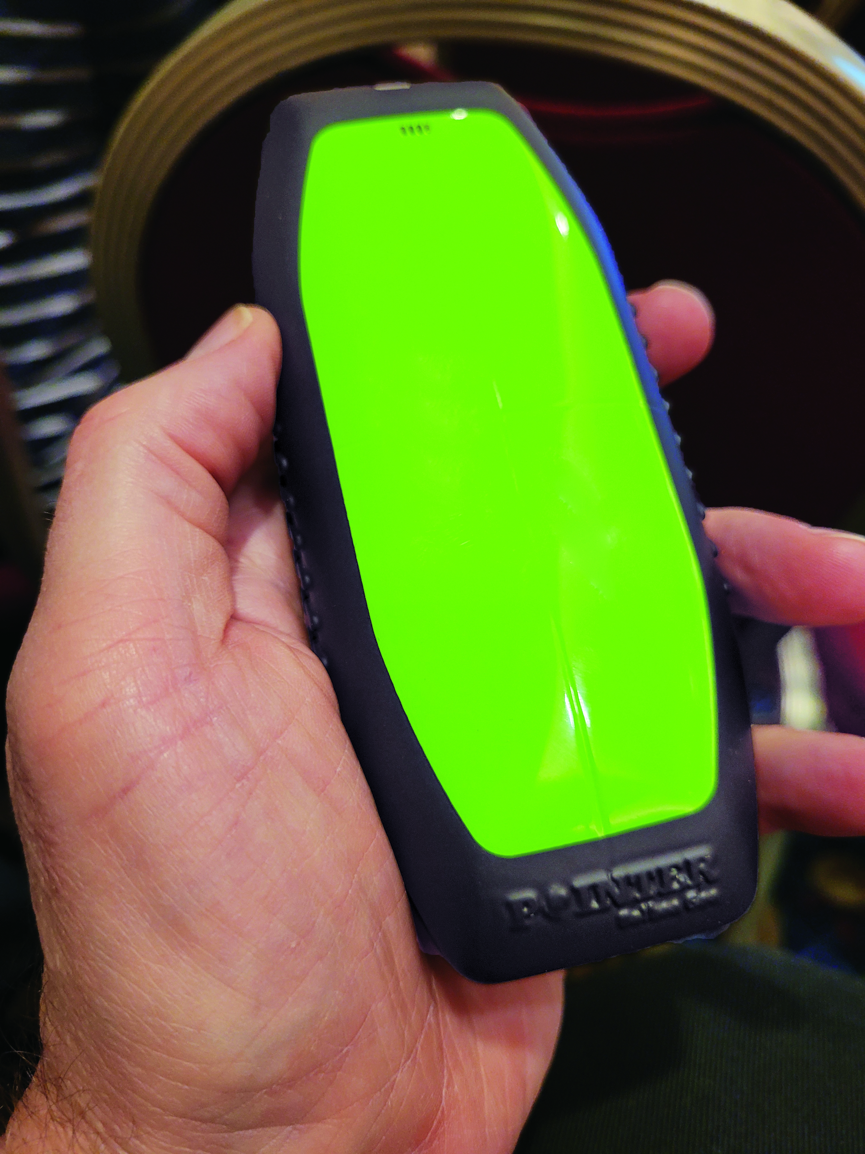
The portable POINTER receivers can be clipped by first responders to their belt, harness, or personal protective equipment, reporting their position in a building, and viewable by an incident commander on a laptop. (Image: Gavin Schrock)
POINTER does not employ radio signals in the fashion of traditional ranging solutions such as GNSS, ultra-wide band (UWB), and various beacon systems for indoor positioning. However, Arumugam said POINTER does generate a radio signal.
“The key difference is that we are detecting the field in a regime where there is no radio propagation mode. Therefore, it is more accurate to refer to this as a quasi-static field, as opposed to a radio propagating wave,” Arumugam said.
Arumugam said Earth’s magnetic field is a good example of this. “It penetrates structures very well, we can measure it 100 kilometers beneath the surface, far above the surface, inside buildings, underwater and so on,” he said. “POINTER uses the kind of the features that you see in Earth’s magnetic field — we are generating quasi-static magnetic fields.
“The term quasi-static highlights the fact that we are trying to keep the physics of the field stationary for all purposes but apply some slow time variation so that it’s really quasi-static to optimize the benefits from both,” Arumugam said. “We get the best of the behaviors of static fields in terms of penetration and non-line-of-sight capability, but also optimize for signal-to-noise by making this a quasi-static signal as opposed to a perfectly static one.”
JPL developed for DHS S&T prototypes that the two organizations tested jointly. Both transmitters and receivers employ an array of three coils, oriented at right angles for x, y and z. The resultant transmitted field carries distinct patterns from these three axes. Distance is detected from field strength, and direction is determined by detecting the pattern of the field relative to the three axes. A key strength of POINTER is that it can achieve ranging and direction from a single base station.
However, Arumugam noted that multiple bases could be beneficial for certain situations.
“The technique as originally developed requires only one transmitter. However, we find that there’s only so much you can get out of a magnetic field, and certain types of structures and materials will perturb that field, causing error.” The second transmitter is not only a backup, but it also helps reduce errors.
POINTER
Geolocation Inc. was spun out from Caltech to license and commercialize POINTER, said Joseph Boystack, executive chairman and co-founder. “We stepped in and executed an exclusive worldwide license for every field of use on this technology in late 2020 from JPL. They had established a proof of concept, and begun testing the technology in the field.”
For the initial commercial version, Balboa Geo made significant improvements over the JPL prototype system. It developed two transmitters that can be deployed on a fixed-mounted basis (buildings, vehicles, ships, etc.) or be portable housed inside a ruggedized, military specification (MIL-STD) case, with a built-in dual antenna GNSS receiver (to position and orient the transmitter).
“If you have an incident involving first responders, military or industrial applications, these remotely configured transmitters can be quickly and easily deployed,” Boystack said. “Also very important, because it only needs to depend on the field generated by the transmitter, we’re not dependent upon other large, fixed infrastructure such as satellites, towers or beacons, and can work in degraded environments where most other position, navigation and timing techniques fail.”
The self-contained receivers are only about the size of a smartphone. The orientation of the receiver is important to determine the “xyz” axis relative to the generated field, thus providing highly accurate three-dimensional position and navigation data. For instance, Balboa Geo’s receiver can be clipped to a first responder’s belt, harness, or personal protective equipment. Similarly, for fixed assets or moving assets such as warehouse systems or robotics, the orientation would be known.
The POINTER system will generate real-time data that can be easily visualized at the job site or event by the incident commander or manager on a laptop or a tablet. The data is interoperable and may be ingested in third-party software applications.
This version meets DHS STS’s original expectations, and subsequent versions will build on it. “S&T relies on experienced emergency response and preparedness professionals to guide our research and development. The First Responder Resource Group is made up of hundreds of state and local volunteers,” Stout said. “We initially looked at tracking firefighters in some of the most common scenarios: two-story house fires.”
While POINTER technology has the potential for much longer ranges and precisions, the current version, Arumugam said, certainly meets the specifications for this initial application. “The current systems can operate up to about 75 meters in range from the transmitter. So, if a transmitter is placed about 10 meters outside the building, say on the fire truck, you can penetrate up to about 65 meters inside the structure. That covers many one, two, maybe three-story structures. Position accuracies can be one meter or less. In principle, you could get to a centimeter, but that’s not required for this technology to be the lifesaver it presently needs to be.”
JPL continues research and development to extend range and increase precision to enable DHS S&T to deploy this technology to ever broader safety-of-life applications where legacy technologies fall short or are completely impractical. Balboa Geo is conducting field and lab tests for many more applications across multiple industries including energy, construction, maritime, mining, the internet of things and more.
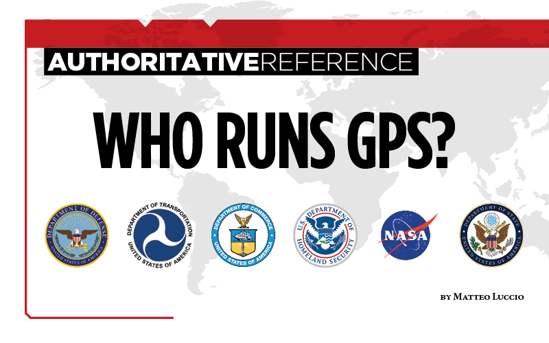
Nearly 50 years ago, in December 1973, the Defense Systems Acquisition Review Council approved the Navstar Global Positioning System for entry into Phase I of development. Since then, through its development, deployment and continuing modernization, GPS has grown into a complex program. It is operated by the Department of Defense based on legislation from Congress, executive orders from the White House, and policies established jointly with the Department of Transportation. It supports U.S. military missions as well as myriad scientific, commercial and consumer applications around the planet. Of course, the last category, with its billions of users, now dwarfs all the other ones combined.
The GPS program, with an annual budget of nearly $2 billion and no user fees, is a gift from U.S. taxpayers to the world. It has staff in Washington, D.C.; at the Pentagon in Arlington, Virginia; at Schriever Space Force Base, Colorado; at the Space Systems Command at Los Angeles Air Force Base, California; at Cape Canaveral, Florida; at the U.S. Coast Guard Navigation Center in Alexandria, Virginia; and at GPS ground antennas in additional locations around the world. From the White House to Congress to aerospace companies, from military officers to civilian civil servants, from policy makers to engineers, from the East Coast to the West Coast to remote islands in the Pacific, Indian and Atlantic Oceans, GPS is a vast enterprise — most of which is little known even to people in the industry and virtually unknown to the public.
The Global Positioning System is a vast and mostly unknown enterprise. This section — the first in an occasional series of authoritative reference pieces in this magazine — aims to clarify who does what to maintain GPS as a fantastic global utility. The relevant missions of agencies or units are in italics.
After I researched and drafted the piece, I asked the experts listed below to review it and provide corrections and additions. While grateful for their substantial feedback, I take sole responsibility for any remaining errors or omissions.
Thank you to the following experts:
Harold W. Martin III, Director, Space-Based Positioning, Navigation & Timing, National Coordination Office
Michael J. Dunn, Capability Area Integrator for PNT, Space Systems Command, United States Space Force
Lt. Col. Robert O. Wray, Commander, 2nd Space Operations Squadron, United States Space Force
Scott R. Calhoun, Commanding Officer, Navigation Center, United States Coast Guard
Paul Benshoof, Technical Director, 746th Test Squadron (AFMC), Central Inertial and GPS Test Facility
Bernard Gruber, Senior Director, Northrop Grumman
Please return to this page periodically to read corrections and updates to this special section. If you spot any significant inaccuracies or omissions, please bring them to my attention by writing to me at [email protected].
The Institute of Navigation is seeking abstracts for the 2023 Joint Navigation Conference (JNC 2023) for the Department of Defense and Department of Homeland Security. The Military Division of the Institute of Navigation will host the conference taking place June 11-15 in San Diego.
The exhibit hall will be open to all conference participants, exhibitors, their employees and related organizations. All materials displayed in the exhibit hall shall be Publically Releasable After Review.
The theme of this year’s conference will be “Enhancing Dominance and Resilience for Warfighting and Homeland Security PNT”.
JNC is the largest U.S. military Positioning, Navigation and Timing (PNT) conference of the year with joint service and government participation. The event will focus on technical advances in PNT with an emphasis on joint development, testing and support of affordable PNT systems, logistics and integration.
The conference will also focus on advances in battlefield applications of GPS; critical strengths and weaknesses of field navigation devices; warfighter PNT requirements and solutions; and navigation warfare.
Abstracts must be written for public release with the intent to present in a Controlled Unclassified Information (CUI) U.S. only environment. Abstracts not approved for public release will not be accepted. Abstracts should be submitted via ion.org/abstracts by February 3.
The 62nd meeting of the U.S. government’s Civil GPS Service Interface Committee (CGSIC) will be held Sept. 19–20 in the Hyatt Regency Denver at the Colorado Convention Center, before the annual ION GNSS+ conference.
It will be hosted by the U.S. Department of Transportation (DOT) and the U.S. Coast Guard Navigation Center (NAVCEN). DOT serves as the civil lead for GPS and chairs the CGSIC in this capacity. NAVCEN is assigned duties as Deputy Chair and Executive Secretariat for the CGSIC.
On Sept. 19, the CGSIC subcommittees for Timing, International Information, and Survey, Mapping, and Geosciences will meet. A summary of these meetings will be presented to the CGSIC Plenary Session on Sept. 20.
Cordell DeLaPena, Program Executive Officer for Military Communications and PNT Space Systems Command
Keynote speaker for the plenary session is Cordell DeLaPena, program executive officer for Military Communications and Positioning, Navigation, and Timing, Space Systems Command, Los Angeles Air Force Base.
The agendas for the CGSIC subcommittee and plenary sessions will include presentations on the operational status and modernization of the GPS constellation of satellites, U.S. space-based positioning, navigation and timing (PNT) policy, GPS augmentation systems, and information related to U.S. engagement with other international GNSS as well as a variety of interesting applications of the use of GPS.
Several new briefings are part of the plenary session this year, including a presentation from NASA on the role of GPS in support of the next lunar mission. Also, the Department of Homeland Security will provide an update on the activities of the Office of Infrastructure Protection, Positioning, Navigation, and Timing Program Management Office.
This year’s meeting will be live-streamed over the internet. For those who are unable to travel, the meetings can be accessed with the links below.
The agenda for the meeting is available; all CGSIC presentations will be available there for viewing online shortly after the meeting ends. As a reminder, all CGSIC meetings are free and open to the public.
Hackers in China managed to gain entry into satellite operators, defense contractors and telecommunications companies in the United States and southeast Asia, reports Reuters.
Reuters spoke with security researchers at Symantec Corp. ahead of public release of a security report. The hackers have been removed from infected systems.
The hackers breached computers that controlled the satellites, including access to orbital systems, Symantec said. GNSS, communication and other data transmissions rely on specifically situated satellites.
Symantec said it has already shared technical information about the hack with the U.S. Federal Bureau of Investigation and Department of Homeland Security.
Registration for the Institute of Navigation’s (ION) Joint Navigation Conference (JNC) 2022 is open and the technical conference program is now available online.
The JNC, sponsored by the Military Division of the Institute of Navigation (ION), will be held June 6–9 at the Town and Country Hotel in San Diego, California. JNC 2022 is a Federal Employees and Contractors U.S.-only conference. Advance visit requests and approvals are required for all attendees.
The event focuses on technical advances in PNT with emphasis on joint development, test and support of affordable PNT systems, logistics and integration. From an operational perspective the conference will focus on advances in battlefield applications of GPS; critical strengths and weaknesses of field navigation devices; warfighter PNT requirements and solutions; and navigation warfare.
The theme of the 2022 conference will be Enhancing Dominance and Resilience for Warfighting and Homeland Security PNT. The technical program includes six panel discussions on Rapid Agile Development and PNT Technology Transition; MGUE Integration; National Critical Infrastructure Threat; Future Space-based Sources of PNT; Situational Awareness; and the Warfighter Panel.
To view the JNC 2022 technical program and register for the event, visit ion.org/jnc.
The trial for the U.S. Department of Homeland Security showcases the precise, resilient timing capabilities of NextNav’s TerraPoiNT service in the event GPS is unavailable.
NextNav has successfully demonstrated the timing precision and resilience of its terrestrial positioning, navigation and timing (PNT) system, TerraPoiNT, in a recent evaluation by the Science and Technology Directorate of the Department of Homeland Security (DHS S&T).
The trial tested the timing redundancy of the TerraPoiNT system in a number of scenarios, including instances of GPS outages, spoofing and jamming. It validates TerraPoiNT’s capabilities as a terrestrial, GPS-free network capable of powering critical national infrastructure in the event of GPS failure.
During a simulated 72-hour GPS outage, the TerraPoiNT service was able to deliver a timing accuracy better than 50 nanosecond in urban and semi-urban environments, successfully meeting timing requirements for various applications including 5G networks, the synchronization of the power grid, and more.
In addition, TerraPoiNT provided precise timing and redundancy utilizing two alternate absolute timing sources — atomic clock (Cesium/Rb) and LEO satellite (Satelles).
“GPS is critical infrastructure, but it has its limitations,” said Ganesh Pattabiraman, co-founder and CEO of NextNav. “In working with DHS S&T, we’ve validated that TerraPoiNT can serve as an important backup to GPS and ensure the resilience and continuity of our nation’s most critical systems, including next-generation telecommunications networks, financial services, and power grids.”
Satelles STL
STL from Satelles was one of two alternate absolute timing sources for the trial. Available today on a global basis, STL is a service that provides alternative PNT independent of GPS, supporting PNT-reliant applications such as 5G communications networks, high-frequency trading in financial markets, and electrical grids throughout the United States and around the world.
“Satelles applauds NextNav for conducting a successful field demonstration of its resilient PNT service, and we were delighted to have played an instrumental part in the exhibition,” said Christina Riley, vice president of Commercial PNT.
NextNav’s selection of STL to help demonstrate their own technology’s operation in the absence of GPS was a natural fit. That’s because earlier this year the U.S. National Institute of Standards and Technology (NIST) confirmed STL as an accurate and reliable source for the wide-area delivery of Coordinated Universal Time independent of GPS/GNSS.
Previous TerraPoiNT evaluations
The successful trial builds on recent evaluations of TerraPoiNT conducted by independent bodies. Earlier this year, the Department of Transportation (DOT) evaluated 11 alternate PNT solutions, in which each was rigorously tested across applications and scenarios. As a result of the evaluation, the DOT named TerraPoiNT the best and only performing solution across all PNT categories.
Spartacus. In June, NextNav entered into a definitive merger agreement with Spartacus Acquisition Corporation in a transaction that would result in NextNav being listed on the Nasdaq. The transaction is expected to close late in the third quarter of 2021 or early in the fourth quarter of 2021, subject to satisfaction of customary closing conditions.
In its closing days, the Trump administration issued several new policy documents affecting positioning, navigation and timing (PNT) issues.
Some have questioned the long-term impact of these, given the significant policy differences between the previous and current administrations. Yet policies in relatively non-controversial areas such as PNT are generally developed by career personnel who tend to remain in place from administration to administration. While they must adhere to the philosophical tenets of extant elected officials, these policies tend to endure longer than others.
Even if this weren’t the case, considering the wealth of other issues the new administration is grappling with, these new policies could remain in force for some time, even if the new regime ultimately decides to change them.
Several themes run through many of the documents. These include:
Space-based PNT is vulnerable and must be protected.
The first of these late-term documents to be published was the National Space Policy issued on Dec. 9, 2020. Highlights and possible impacts for the PNT community include:
A goal to “Promote and incentivize private industry” could have implications for low-Earth orbit (LEO) PNT services.
A goal to “Increase the assurance of national critical functions” could include GPS/PNT resilience.
A pledge to “Safeguard space components of critical infrastructure” undoubtedly includes GPS. The section also has ominous statements about U.S. responses to purposeful interference and tasks the Defense and Homeland Security secretaries with having those responses ready.
Another pledge to “Maintain and Enhance Space-based Positioning, Navigation and Timing (PNT) Systems” is followed by eight explanatory paragraphs, many of which repeat previous policy. One new item is a promise to invest in detection and mitigation of harmful interference. A mention is also made of the need for multiple and diverse PNT sources, and responsible use of PNT, echoing the February 2020 Executive Order on the subject. Both of the latter two mentions were in the context of critical infrastructure and mission essential functions versus the security of the nation and economy as a whole.
Congress mandated a GPS backup technology demonstration in 2017, and $10 million was subsequently provided for that purpose. Various internal government delays resulted in the project not getting underway until March 2019. It concluded about a year later.
While some people have been critical, it is important to remember the report documents 11 vendor demonstrations, not engineering tests. Technologies were demonstrated in different locations and under differing conditions.
There is no silver bullet for meeting the nation’s needs. It must be a system of systems.
Also, the amount of effort and equipment in the demonstrations depended in some cases upon infrastructure available and the amount of money the government and vendors were able to spend. This meant that at least one technology was “demonstrated” mostly by explaining the concept, and other vendors were able to only partially demonstrate their technologies.
All of that said, the report offers valuable information about how America should make its national PNT much more resilient and reliable. First, it reinforces DOT’s message that there is no silver bullet for meeting the nation’s needs. It must be a system of systems. Second, the report goes further and says what that system of system should look like: “Those technologies are LF and UHF terrestrial and L-band satellite broadcasts for PNT functions with supporting fiber-optic time services to transmitters/control segments.”
From a policy perspective, this is a huge step forward. It resolves previous ambiguity and positions the nation to establish a resilient PNT architecture, one that will do more than be a “GPS backup.” It will be an architecture that will better support current applications and better enable emerging ones like autonomy, 5G and “NextG.”
Published one hour and fourteen minutes before the end of the administration on inauguration day, this plan was mandated as part of the February 2020 Executive Order on responsible use of PNT. By taking a comprehensive look at how we can do better, it provides an interesting outline of the challenges associated with America’s current over-reliance on GPS. While not a policy or directive document, it does suggest two or three departments and agencies that might be tasked with addressing each challenge.
It also addresses the need for interference detection and monitoring, and diverse sources of PNT.
This directive was published five days before the end of the administration and replaced the previous policy, 2004’s NSPD-39.
While the old policy calls for performance monitoring of GPS signals, the new one also has investment in interference detection and monitoring as a goal.
Perhaps the most significant change in the new policy was the absence of the words “backup capability” and the lack of a mandate for DOT to lead its establishment. Yet the policy hammers home multiple times the need for more than GPS as a source of PNT. And it doesn’t abandon the idea of government involvement in making that happen.
In addition to reinforcing Executive Order 13905 on responsible use of PNT, the directive defined a new (for presidential policies) term. “Alternative PNT Service” was described as “a PNT service that has the capability to operate completely independent of, or in conjunction with, other PNT services.” The directive goes on to say that “Multiple, varied PNT services used in combination may provide enhanced security, resilience, assurance, accuracy, availability and integrity. An alternative PNT service allows a user to transition from the primary source of PNT signals in the event of a disruption or manipulation.”
And while the policy does not say the government will establish or support an alternative PNT service, it comes pretty close. One of its goals is “Invest in… as appropriate, alternative sources of PNT for critical infrastructure, key resources, and mission-essential functions.”
It goes on to task the departments of Defense, Homeland Security and Transportation with making that happen.
So “backup” is out, “alternative PNT” is in. We agree words are important and are happy to have the new words. Let’s hope the new administration will match the new words with action (as appropriate).