The European Union Aviation Safety Agency (EASA) has certified Madrid-based European Satellite Services Provider (EESP) as a pan-European communication services provider for Iris data link services.
Iris, a project supported by the European Space Agency (ESA) and various European partners, aims to develop a satellite-based air-ground communication system to enhance air traffic management. By 2028, Iris will enable full 4D trajectory management of airspaces globally, making it a crucial means of communication between cockpit crews and controllers.
The certification of ESSP as an Iris data link services provider comes after more than a year of testing and audits at both ESSP and Inmarsat premises. The certification establishing compliance with relevant regulations and associated industrial standards for data link services.
Additionally, ESSP recently signed a long-term contract with Viasat/Inmarsat to act as the Service Provider for Iris data link services, powered by Viasat’s SwiftBroadband Safety (SB-S) connectivity. As The European Geostationary Navigation Overlay Service (EGNOS) service provider, ESSP is already under a long-term contract with the European Agency for the Space Program (EUSPA), where it carries out EGNOS operations and maintenance.
Iris is scheduled to be fully operational in Europe by 2024, providing services to airlines such as easyJet and ITA Airways. ESSP will lead the commercialization of Iris services, targeting European Air Navigation Service Providers (ANSPs). The service provision consortium includes ESSP SAS, Inmarsat, and SITA, with other communication network providers expected to join in the future.
Inmarsat has partnered with Australia and New Zealand to deliver the Southern Positioning Augmentation Network (SouthPAN), which will provide accurate, reliable, and instant positioning services in the Asian Pacific region. The positioning service will be delivered on one of Inmarsat’s three new I-8 satellites in 2027.
SouthPAN will improve positioning accuracy to 10 cm for users in the maritime, agriculture and construction industries.
“SouthPAN represents extraordinary potential for the region,” Todd McDonell, president of Inmarsat Global Government, said. “It can save lives by enabling precision safety tracking, help farmers improve productivity through automated device tracking, or even support transport management systems of the future.”
The Inmarsat I-8 satellites will also be a critical part of a safety-of-life-certified SouthPAN for aviation and other applications, scheduled for 2028.
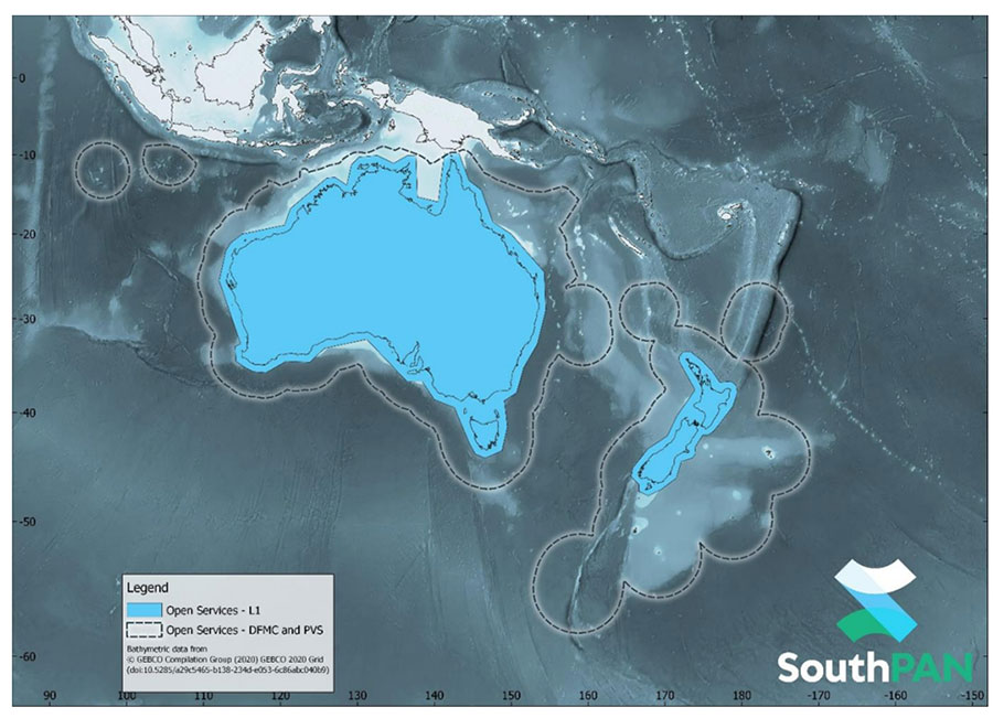
SouthPAN early Open Services coverage. (Image: Geosciences Australia)
The government of Australia has awarded Lockheed Martin a $1.18 billion contract to establish the Southern Positioning Augmentation Network (SouthPAN) to enhance precision.
The system is expected to be fully operational by 2028, and will be provided as a service for 19 years with an option to extend.
The program will use a unique, Lockheed Martin-developed, second-generation satellite-based augmentation system (SBAS) broadcasting on two frequencies to augment signals from two GPS and Galileo.
The SouthPAN initiative
The SouthPAN initiative will deliver a signal augmenting GPS and Galileo over the Australasia region, improving accuracy from 5-10 meters to within as little as 10 centimeters.
The greater positioning accuracy and integrity of the SouthPAN signal has applications across a range of users, including civil aviation, vehicle guidance, precision agriculture for efficiencies in crop management, tracking maritime shipments, and enabling navigation for drones and other unmanned vehicles.
Lockheed Martin Australia will work with the SouthPAN project team to establish a network of GNSS reference stations and satellite uplink facilities that will enable communications and transmissions with the SouthPAN space infrastructure.
SouthPAN is a partnership between Geoscience Australia and Toitū Te Whenua Land Information New Zealand (LINZ) under the Australia New Zealand Science, Research and Innovation Cooperation Agreement.
2017 testbed
Lockheed Martin tested a second-generation SBAS testbed in partnership with Geoscience Australia in 2017.
Lockheed Martin’s second-generation SBAS technology receives and monitors basic signals data from multiple GNSS through widely distributed reference stations. This data is collected by a SBAS testbed master station, which computes corrections and integrity bounds for each GNSS satellite signal, and generates augmentation messages.
The new messages are sent to an SBAS payload hosted aboard an Inmarsat geostationary Earth orbit satellite via an uplink antenna in Uralla, New South Wales. The Inmarsat satellite rebroadcasts the augmentation messages containing corrections and integrity data to the end users’ GNSS receivers. The whole process takes less than six seconds.
Lockheed Martin provided the systems integration expertise in addition to the Uralla radio frequency uplink; GMV-Spain provided its “magicGNSS” processors; Inmarsat provided the navigation payload hosted on the 4F1 geostationary satellite. The Australia and New Zealand Cooperative Research Centre for Spatial Information coordinated the demonstrator SBAS test-bed SBAS test-bed projects.
The SouthPAN contract will expand Lockheed Martin’s investments toward sustainable business growth in Australia. Currently, Lockheed Martin programs support 4,000 Australian jobs in advanced manufacturing and technology industries. The contract will grow that footprint with additional jobs in at least four states.
“Seen & Heard” is a monthly feature of GPS World magazine, traveling the world to capture interesting and unusual news stories involving the GNSS/PNT industry.
Photo: spxChrome/E+/Getty Images
Citizens Clean Up Coasts
Two citizen groups are taking action with the help of Esri ArcGIS mapping tools. North Coast World Earth uses Esri Ireland’s platform on the Northern Irish coast to record litter hotspots and engage with local communities. The volunteer group has collected nearly 3 tons of litter. In California, the Surfrider Foundation employed ArcGIS Hub to streamline cleanup operations after a major oil spill off Huntington Beach in October 2021. Citizens submitted more than 1,100 reports using the ArcGIS QuickCapture photo app to share the date, time and coordinates of toxic tar balls on beaches from Oxnard to San Diego.
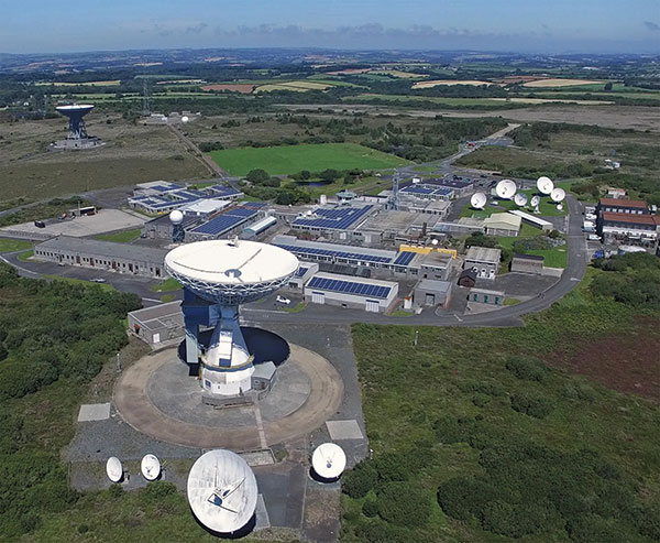
A new series of tests will assess whether the United Kingdom satellite-based augmentation system (UKSBAS) for GNSS can develop into full operational capability to support safety-critical applications post-Brexit. Inmarsat, Goonhilly Earth Station and GMV NSL are conducting the UK Space Agency-funded tests. The signal is now stable and operational, enabling ongoing testing and validation by industry, regulators and users. If successful, UKSBAS will enable assessment of more precise, resilient and high-integrity navigation for maritime and aviation users in UK waters and airspace.
Image: ESA
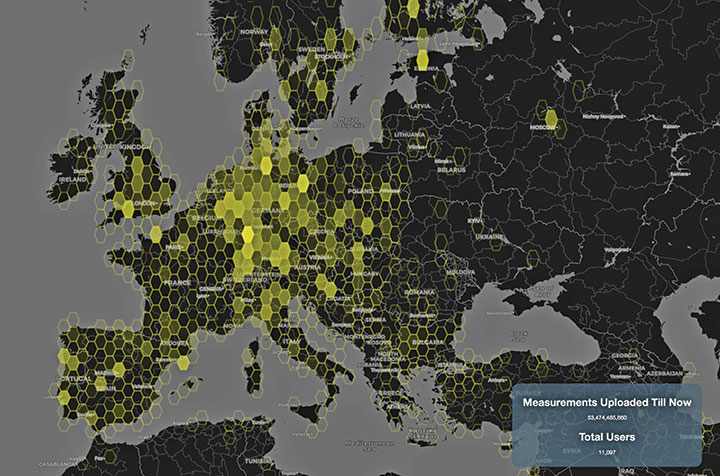
Smart GNSS Monitoring
More than 11,000 people around Europe and the world have turned their smartphones into GNSS monitoring tools by downloading the CAMALIOT app, so far delivering more than 53 billion measurements of meteorology and space weather patterns to researchers, reports the European Space Agency (ESA). ESA asks CAMALIOT volunteers to leave their smartphones by a window each night with GNSS on. The phones record small variations in satellite signals, gathering data for machine-learning analysis. More than 50 smartphone models with dual-frequency receivers can use the app.
Indian Prime Minister Narendra Modi gave his stamp of approval to his country’s indigenous NavIC during a drone festival May 27. Despite that, the Indian Army purchased three GNSS receivers from Baidu, a Chinese company, instead of relying on home-grown companies as the contract required, reports The New Indian Express. The receivers are for survey stations of the College of Military Engineering. A few Indian manufacturers objected to the purchase, the newspaper said, but their concerns were brushed aside by the Department of Military Affairs.
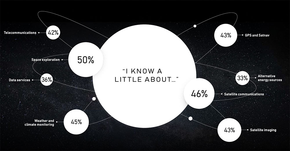
The satellite company spoke to 20,000 people in 11 countries across the globe to uncover their perceptions of space, what happens “up there” and how they think it impacts life here on Earth.
The survey found that most people have no idea about the benefits of space. Only one third are excited about space, with 47% concerned about space junk and just 8% associating space with communications and connectivity.
Just 8% of respondents associate space with communications and connectivity.
“From connecting rural communities to helping solve climate change, we know the enormous potential space holds to improve life on Earth, and what it has already brought us,” Inmarsat said in a statement. “Now, both the magnificent possibilities and the potential risks of space, which Inmarsat is working hard to address, need to be showcased to the world.”
The report also features contributions from renowned figures in the sector including Scott Kelly, former astronaut and commander of the International Space Station, and Josef Aschbacher, director general of the European Space Agency.
“The research findings mark a real wake-up call for the space industry,” Inmarsat said. “It’s clear that people have a low understanding of the breadth and richness of the work being done in space today. Perhaps because the technology deployed is essentially invisible, people do not appear to understand the role space is already playing in their everyday lives, nor its potential to deliver a brighter future for our planet.”
The tests will assess whether UKSBAS can develop into a full operational capability to support safety-critical applications
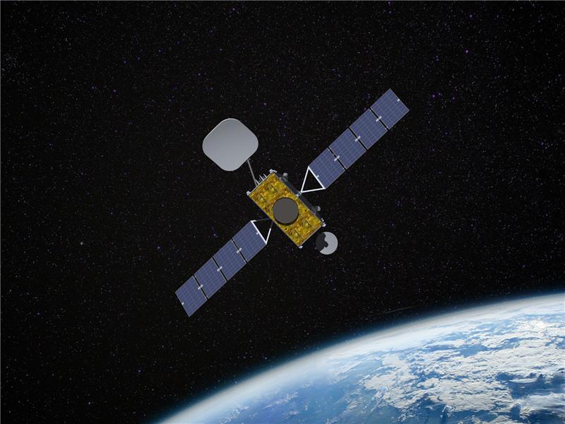
Artist’s impression of an Inmarsat-3 satellite. (Image: Inmarsat)
An Inmarsat-led team of companies in the United Kingdom has begun broadcasting a satellite navigation signal as part of a program to explore the creation of a sovereign national capability in resilient positioning, navigation and timing (PNT) for the aviation and maritime sectors.
The signal, being broadcast in coordination with the U.S. Federal Aviation Administration (FAA), the European Space Agency (ESA) and the European Union Space Programme Agency (EUSPA), is now stable and operational, enabling ongoing testing and validation by industry, regulators and users.
Inmarsat, a satellite communications company, alongside British partners Goonhilly Earth Station and GMV NSL, is delivering the UK Space Agency-funded tests with the European Space Agency via ESA’s Navigation Innovation and Support Program (NAVISP).
The UK Space-Based Augmentation System (UKSBAS) generates an overlay test signal to the U.S. GPS, compliant with International Civil Aviation Organization (ICAO) standards, to enable assessment of more precise, resilient and high-integrity navigation for maritime and aviation users in UK waters and airspace. It increases accuracy in positioning to a few centimeters of accuracy rather than the few meters provided by standard GPS.
This is a similar system to that already under evaluation in Australia and New Zealand, supported by Inmarsat.
Since leaving the European Union, the UK is not part of the Galileo satnav system and cannot use the European Geostationary Navigation Overlay Service (EGNOS) safety of life (SOL) services, which enable the use of GPS for airport approach and landing operations for aircraft. The UK ceased to have access to EGNOS on June 25, 2021.
By repurposing the SBAS transponder on Inmarsat’s I-3 F5 satellite in geostationary orbit at 54° west, the UKSBAS signal enables testing of this potential alternative system. Built by Inmarsat’s Athena partner Lockheed Martin and launched in 1998, I-3 F5 covers the UK as part of its Atlantic Ocean region service overlay. This makes it a suitable candidate to participate in this test and demonstrates the commitment to sustainability of Inmarsat with a satellite that has already served the equivalent of several low Earth orbit (LEO) satellite life cycles.
“The Inmarsat team is inspired by delivering solutions to new problems through technology and innovation,” said Todd McDonell, president, Global Government at Inmarsat. “Repurposing a transponder on a long-serving satellite to deliver a new capability to the UK, potentially a vital and enduring one, certainly lives up to that core Inmarsat ethos. Working with our fellow British companies at Goonhilly and GMVNSL to deliver such a capability for the country is very rewarding, and we look forward to reporting on the results.”
The tests will assess whether UKSBAS can develop into a full operational capability to support safety-critical applications such as airport approach and landing operations or navigating ships through narrow channels, especially at night and in poor weather conditions.
Goonhilly provides the signal uplink for the system from Cornwall; software from Nottingham-based GMVNSL generates the necessary navigational data.
“The UK’s thriving space sector is developing at pace, and British-led innovations like this have the potential to deliver crucial navigation services for our aviation and maritime sectors.” said Transport Minister Robert Courts. “That’s why this government is investing millions in new technologies to make our transport network even safer while boosting high-skilled job opportunities across the nation.”
UKSBAS is helping to regenerate UK strategic capabilities in this domain. The establishment of this new national platform creates the opportunity to evaluate high-integrity, resilient and precise navigation across the country, in its airspace and within surrounding waters. The project may be crucial for UK users who need accurate, high-integrity navigation capabilities to enable their operations, initially covering aviation and maritime operations but with potential extension into rail and road applications.
“Congratulations to Inmarsat, Goonhilly and GMVNSL on this impressive achievement,” said Paul Bate, CEO of the UK Space Agency. “In recent years, the UK Space Agency has invested in the development of UK expertise in positioning, navigation and timing (PNT), and the government’s commitment to strengthening PNT resilience is set out in both the National Space Strategy and Integrated Review, given its importance to our critical national infrastructure and economy. “This project is a great example of the innovation found throughout the UK space sector and demonstrates how we can work effectively with the European Space Agency to strengthen our national space capabilities.”
Satellite communications company Inmarsat is working on a United Kingdom Space Agency-funded test project with the European Space Agency to deliver the first UK-generated satellite navigation signal. The project provides a potential platform for the UK to enhance its post-Brexit positioning, navigation and timing (PNT) capabilities.
Repurposing a transponder from the Inmarsat-3 F5 satellite, the test project — known as UK Space-Based Augmentation System (UK SBAS) — will provide an overlay signal to augment the U.S. GPS, refining its accuracy from a few meters to a few centimeters.
UK PNT without EGNOS
The UK no longer has access to the European Geostationary Navigation Overlay Service (EGNOS) Safety of Life services since leaving the European Union (EU) and is not involved in the EU’s Galileo programme for similar reasons. Therefore, this new national capability supported by current and future Inmarsat satellites could offer a new option for high-integrity, precision navigation across the country, in its airspace and within surrounding waters.
UK SBAS will provide a basis to assess its future development into an operational capability to support safety-critical applications such as aircraft approaching and landing at airports or navigating ships through narrow channels, especially at night and in poor weather conditions.
Goonhilly will provide the uplink for the system from Cornwall. Software from GMV NSL, based in Nottingham, will generate the ground-based navigation signal. This is a similar system to that already in use in Australia and New Zealand, supported by Inmarsat.
The project could be crucial for UK users who need accurate, high-integrity navigation capabilities to enable their operations. It will initially cover aviation and maritime operations, but has the potential to extend into rail and other land-vehicle applications. For example, UK SBAS will comply with International Civil Aviation Organization (ICAO) standards.
“It is very welcome news to hear that UK-based companies have teamed up to deliver this ground-breaking project, with help from government funding,” said Transport Minister Trudy Harrison. “From flying planes to steering ships, reliable and precise navigation support is a crucial part of travel. This development is a significant step forward for our world-leading space sector, as we accelerate towards a net-zero transport future.”
Best satellite candidate
Artist’s impression of an Inmarsat-3 satellite. (Image: Inmarsat)
The Inmarsat-3 F5 satellite is in geosynchronous orbit at 54° west, ensuring that its signal covers the UK as part of its Atlantic Ocean region service overlay. This makes it an ideal candidate to participate in the test. The satellite was manufactured by Inmarsat’s Athena partner Lockheed Martin and launched in 1998.
“This project demonstrates British innovation at its best,” said Nick Shave, vice president of Strategic Programmes for Inmarsat Global Government. “Working with Goonhilly Earth Station and GMVNSL, supported by UK funding via the ESA Navigation Innovation and Support Programme (NAVISP), enables us to extend the long life of Inmarsat’s I-3 F5 satellite with additional new services designed two decades after launch.
“We look forward to exploring the potential for this project and the benefits it could deliver to the UK with more precise, high-integrity, resilient navigation services, whilst also exploring future capabilities on new satellites through Inmarsat’s fully funded technology roadmap,” Shave said. “This work also has the potential to be exported to other nations around the world, benefitting the UK economically as well as technologically.”
New Inmarsat research reveals a rapid increase in levels of industrial IoT maturity in 2021, with agricultural businesses accelerating IoT adoption in response to COVID-19
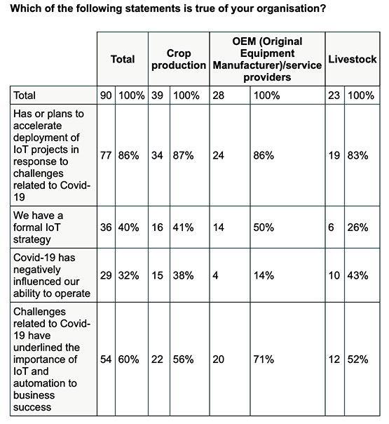
Research by Inmarsat, a global mobile satellite communications company, reveals a rapid increase in the maturity level of the industrial internet of things (IoT) across the agricultural sector since the start of the COVID-19 pandemic, with 86% of ag business accelerating or intending to accelerate deployment.
Respondents in the report, “Industrial IoT in the Time of COVID-19,” include crop producers, OEMs, service providers and livestock businesses, who report that COVID-19 demonstrated the importance of IoT to their businesses.
According to the research, adoption has seen huge progress from 2020 to 2021, with automation and cost savings the greatest drivers. Four-fifths (80%) of agricultural respondents have now fully deployed at least one IoT project, with 53% having achieved this in the 12-month period from the second quarter of 2020. Of the remaining 20% of agricultural respondents that have not yet adopted IoT in any form, all of them are either currently trialing it, or plan to deploy or trial at least one IoT project in the next two years.
Chart: Inmarsat
A further 86% of agricultural respondents indicated they have or they intend to accelerate the adoption of IoT in response to challenges related to COVID-19. This figure includes 46% who have already accelerated IoT adoption to respond to COVID-19, versus 29% who will accelerate over the next 12 months and 11% who will accelerate beyond the next 12 months.
The 46% that have already accelerated IoT adoption are less likely to state that COVID-19 has negatively impacted their ability to operate, demonstrating a link between IoT and business continuity during the pandemic. Additionally, more than half (60%) of respondents in the sector indicated that business and operational challenges related to COVID-19 have underlined the importance of IoT.
“We have seen agricultural producers take on more and more solutions that allow them to operate remotely, from autonomous irrigation control to the latest precision farming technologies, demonstrating increased faith in the technology,” said Steven Tompkins, Director of Market Development at Inmarsat.
As part of the research, Inmarsat is offering businesses the opportunity to measure their IoT readiness compared to the respondents in the survey, using their free IoT maturity tool.
Tallysman Wireless has added new eXtended Filtering (XF) features to the TW3900 series of Accuntena precision antennas. Tallysman designed the XF feature to mitigate interference from all near-band signals and ensure that the antenna provides the purest GNSS signals.
Tallysman’s TW3972XF, TW3972EXF, TW3972LGXF, TW3967XF, and TW3967LGXF are triple-band antennas that support GPS/QZSS (L1/L2/L5), GLONASS (G1/G2/G3), Galileo (E1/E5ab), BeiDou (B1/B2/B2a), NavIC L5, and L-Band correction services.
Worldwide, the radio frequency spectrum has become congested as many new LTE bands have been activated, and their signals or harmonic frequencies can affect GNSS antennas and receivers. In North America, the planned Ligado service, which will broadcast in the frequency range of 1526 to 1536 MHz, can affect GNSS antennas that receive space-based L-band correction service signals (1539–1559 MHz).
The TW3972-XF antenna. (Photo: Tallysman)
New LTE signals in Europe [Band 32 (1452–1496 MHz)] and Japan [Bands 11 and 21 (1476–1511 MHz)] have also affected GNSS signals. Lastly, the Inmarsat satellite communication uplink (1626.5–1660.5 MHz) commonly used on maritime vessels can also affect nearby GNSS antennas.
Tallysman’s custom XF filtering has been tested to mitigate new (Europe and Japan) and existing LTE signals, enabling the XF antennas to produce clean and pure GNSS radio frequency data. The deep XF filter technology will be applied to all of Tallysman’s product lines.
Tallysman Wireless is offering two new VeroStar marine antennas to its line of GNSS products. The VSP6037L-MAR supports the full GNSS spectrum and the VSP6337L-MAR supports GPS/QZSS-L1/L2/L5, GLONASS-G1/G2/G3, Galileo-E1/E5a/E5b, BeiDou-B1/B2/B2a, and NavIC-L5 signals. Both antennas support L-band correction signals.
Marine vessels often host both Iridium (1616–1626.5 MHz) and Inmarsat (uplink: 1626.5–1660.5 MHz) satellite communication antennas that transmit and receive signals. The VSP6037L-MAR and VSP6337L-MAR VeroStar marine antennas strongly attenuate interference from both signal sources, providing 75 dB to 85 dB of attenuation over Iridium and 85 dB to 95 dB over Inmarsat uplink, enabling clean GNSS signal reception and precise positioning.
Every VeroStar antenna features a robust pre-filter and a high-IP3 LNA architecture, minimizing de-sensing from high-level out-of-band signals, including 700 MHz LTE, while still providing a noise figure of only 1.8 dB.
VeroStar antennas provide the best-in-class low elevation angle tracking of the full GNSS spectrum and L-band correction signals. The wideband spherical antenna element enables VeroStar antennas to deliver ±2 mm phase centre variation (PCV), making them suitable for high-precision marine, positioning and machine control applications.
The VeroStar marine antennas are housed in a rugged and compact enclosure that supports 1-inch pipe thread or 5/8-inch-11 TPI mounting and provides a TNC antenna connector. The antennas have also obtained the stringent IEC 60945 and IEC 61108 marine certifications, making them suitable for challenging marine environments.
Altitude Angel and Inmarsat are collaborating to develop and deliver advanced flight tracking and management capability for UAVs.
According to the companies, they will build on Altitude Angel’s GuardianUTM platform to jointly develop a “pop-up UTM” capability that can be deployed anywhere it is required to manage beyond visual line of sight UAV flights, without the need for ground-based communications infrastructure. By utilizing Inmarsat’s global network of satellites and leveraging its experience in air traffic management communications, Altitude Angel’s pop-up UTM can be accessed rapidly and deployed worldwide, the companies added.
The pop-up UTM will be developed initially to address the unmanned traffic management needs of blue light emergency services and first responders who need aerial surveillance rapidly with little notice. The companies plan to release a commercial, industry-focused product soon after. Through this technology, emergency services will be able to remotely manage UAVs, increasing their range of safe operations in mixed airspace of manned and unmanned vehicles.
“The ability to almost instantly ‘pop-up’ safe, secure and fully operational UTM platforms in any environment, at any time, will give first responders, blue light services and aid organizations a valuable tool that could save countless lives,” said Phil Binks, head of air traffic management at Altitude Angel. “Altitude Angel and Inmarsat, in developing ‘pop-up UTM,’ will be able to bring connectivity, clarity and automated air traffic control services for UAVs in even the most challenging of circumstances.”
Altitude Angel is an aviation technology company delivering solutions which enable the safer integration and use of fully automated drones into airspace. Inmarsat is a British satellite telecommunications company, offering global mobile services.
Research shows Internet of Things growing in use; free IoT maturity tool enables miners to measure readiness
Cover: Inmarsat
The latest research study conducted by Inmarsat, a global, mobile satellite communications company, found that the global mining sector is undergoing an internet of things (IoT) revolution with respondents reporting significant increases in adoption of connected technologies.
Inmarsat employed market research company Vanson Bourne to interview 200 respondents with either decision-making or influencing responsibilities for IoT-related initiatives at organizations of more than 500 personnel.
Mining organizations reported successes in implementing projects to safeguard workers via remote tracking, monitor drilling and observing acid mine-drainage remotely. However, despite this progress, a range of challenges are hindering the sector’s ability to reap the rewards IoT has to offer.
‘The Rise of IoT in Mining is the third IoT-focused research project undertaken by Inmarsat and focuses on the use of, attitude to and predictions for IoT across the global mining sector. As part of the initiative, Inmarsat is also offering mining companies the opportunity to measure their IoT readiness versus the 200 respondents to the survey, using their free online IoT maturity tool.
According to the research, most organizations (65%) have fully deployed at least one IoT project, while 33% are trialling or have trialled a project, with only 2% of respondents not having begun an IoT project.
These findings echo the predictions reported in Inmarsat’s 2018 mining research, where only 2% had fully deployed an IoT solution, 29% were trialling one and 69% were planning on beginning IoT projects within the next two years.
Noticeably, there is a considerable geographical variance in IoT adoption and maturity across different regions, with 98% of North American respondents having successfully deployed IoT-enabled projects, compared with only 50% in Africa and 38% in South America.
While this increase in full deployments represents progress, the use cases and data management are on the simple side and there are many challenges to overcome if the mining industry is to fully realise the potential of IoT, particularly in regard to using it as driver for organisational change.
A lack of skills, investment and cultural challenges, as well as unreliable connectivity, patchy cybersecurity processes and underdeveloped data management processes were also highlighted in the report and will all need to be remedied in the coming years.
“Two years on from our last research, Inmarsat wanted to get a measure of what had changed in the mining industry,” said Joe Carr, global mining director at Inmarsat. “IoT has begun to take a foothold in the sector with increased rates of adoption across the board. What we discovered was an industry that — historically slow to adopt radical ideas — is now beginning to embrace the use of IoT, but still working out how to make the most of it.”
The mining industry faces significant challenges around skills, security, connectivity, investment and data management. These will need to be addressed for the industry to progress past a point of using IoT in a simple, siloed capacity, according to the report.
Despite the challenges being faced, mining organizations are looking to increase their investment in IoT and are overwhelmingly positive about the value that IoT can bring to their operations and the benefits it is either already delivering or will deliver in the future.
“We want to help drive IoT adoption in the mining sector and encourage mining companies to plot a route to IoT success using our free online IoT Maturity Tool,” Carr concluded. “The tool allows miners to understand their progress in IoT adoption across a number of areas and to compare this with the 200 respondents who contributed to our research. Using these findings miners can start to develop a roadmap for improvement and provide a tangible proof point for influencing internal conversations.”