The U.S. Navy has selected Northrop Grumman to advance its airborne navigation capabilities by integrating Northrop Grumman’s LN-251M, the upgrade of the LN-251 inertial navigation system (INS)/GPS. This new system incorporates M-Code technology, which provides an encrypted, military-specific signal with improved resistance to jamming, offering better protection against potential threats.
According to the company, the LN-251M represents a significant advancement in naval aircraft navigation, being the first M-Code navigation system designed for this purpose. The M-code technology offers increased robustness against GPS signal degradation, which allows pilots to operate more effectively in areas where GPS signals may be compromised or unavailable.
The LN-251 series is designed to integrate seamlessly with existing aircraft navigation systems and is compatible with future software and GPS modernization upgrades.
EpiSci and Northrop Grumman have entered a strategic collaboration to develop and deploy advanced autonomous tactical solutions to the United States and its allies.
Under the collaboration, EpiSci’s TacticalAI software will be integrated into Northrop Grumman’s aeronautics system architecture. This integration is anticipated to significantly enhance the operational efficiency and success of warfighter missions through trusted autonomous technologies, according to EpiSci.
The collaboration uses the U.S. government’s open-architecture design, allowing Northrop Grumman’s autonomy solutions to incorporate third-party technologies. This allows UAVs to adapt to evolving mission requirements and offers military commanders greater flexibility in complex scenarios.
EpiSci’s TacticalAI technology is designed to improve autonomous solutions for human-machine teaming. It offers cognitive sensing, adaptive communications and networking systems, and battle management command and control (BMC2). This technology is being developed to enhance autonomous defense capabilities across a wide range of platforms, including uncrewed aerial and maritime systems, as well as tactical fighter aircraft.
What are the key challenges and promising trends for GNSS/PNT over the next three to five years?
Bernard Gruber
“In 2023, the GPS program celebrated its 50th anniversary. It has had untold positive impacts on the world. I strongly believe this trend will continue through GNSS and complementary PNT systems for the next 50 years! That said, continuing challenges faced in the era of great power competition — specifically, to disrupt, deny, and destroy PNT capabilities — pose a clear and present danger. Ingenuity, competition, and strong coalitions will drive how we think and how we utilize our incredible resources – human and system – to persevere.
Unfortunately, challenges will always exist. Since the beginning, the GNSS community has had to deal with jamming threats, such as pervasive black market ‘cigarette lighter’ jammers, militarily sophisticated ones, or brute force high powered systems. This challenge will not go away. The burgeoning of artificial intelligence and machine-to-machine computations offers an opportunity and poses a threat: as commercial and government entities embrace these technologies, they exponentially increase the need to adapt.
Several promising trends will continue. Through the hard work of countless governmental organizations supporting the National Coordination Office, periodicals such as GPS World, academic papers, conferences and symposiums, marketing and communications, the public is now aware of how vital GNSS and PNT systems are. Second, buyers, operators, and users will demand that robustness be built into systems by anticipating needs such as increased cybersecurity, assured access, and tiered defense schema.
Third, innovative technical trends will drive increased processing power, cybersecurity/encryption toughness, signal diversity, adaptive antennas, and network augmentations, while an ever-increasing focus on model-based engineering and digital twins will allow us to field and learn faster. Additionally, as signal diversity grows, the opportunity for software-defined radios that utilize authenticated and available signals while ignoring others automatically will mature; programs such as the NTS-3 demonstration will at minimum force the decision of how we adapt.”
— Bernard Gruber Northrop Grumman
Jules McNeff
“Trends have emerged and evolved over the last three decades — since GPS became operational — that addressed earlier challenges and yet have created new, and possibly more daunting, ones. Early issues with awareness and acceptance of the need for continuous, precise positioning, navigation and timing (PNT) have been overcome, and the markets and governments have responded with a proliferation of PNT services — both space-based and other.
I’ll leave the market trends and opportunities to our industry colleagues and focus more closely on some remaining challenges that are particularly vexing to me. That requires stepping outside the comfortable GNSS/PNT-as-a-technology engineering and science bubble full of topics for collegial international cooperation. Instead, one must look at GNSS/PNT as an incredibly valuable tool for public safety, political and economic advantage, and military dominance, all separate, but closely interrelated and so as a tool to be protected. Other nations, some unfriendly to the United States, recognize the political/economic reality and are deploying PNT services to compete with GPS and erode international public confidence.
The U.S. government appears complacent and naively unwilling to accept that changes are necessary in its approach to international economic competition in PNT technology over the immediate future. Similarly, in the public safety arena, most of U.S. critical infrastructure (CI), an area of federal government responsibility, is well-known to be vitally dependent on GPS to function. However, the government agencies responsible for CI have been beyond reluctant to implement needed resilience measures, specifically regarding the terrestrial enhanced Loran (eLoran) system, which would provide substantial resilience if GPS service were lost or disrupted. This is despite multiple requests over the last decade from Congress and the National PNT Advisory Board to recapitalize eLoran.
At the same time, friendly and hostile foreign nations invest in their own eLoran systems to bolster PNT resilience within their sovereign territories. Knowing this, the United States cannot be happy with a situation that threatens economic and national security, yet it persists. Finally, and also important to public safety, we need to get serious about how PNT positions (geoaddresses) are reported to the public – important for economic purposes and specifically for incident/accident location and emergency response operations of all kinds. Continuing reliance on lat/lon as a default or on unique proprietary methods is both ineffective and dangerous given the ready availability of the U.S. National Grid as a public resource, as identified in the U.S. Federal Radionavigation Plan. As with eLoran above, the public safety challenge is to save lives and livelihoods and not allow them to remain at risk.
— Jules McNeff Overlook Systems Technologies
Jean-Marie Sleewaegen
“Recent years have seen a spectacular boost in the number of global navigation satellite systems (GNSS) satellites and signals. The launch pace has now slowed down, which does not mean the end of GNSS innovation. On the contrary, now comes the time to exploit and get the best out of all these new signals and services.
One of the first benefits of signal diversity is improved resilience: the more signals, the more fallback options in case of jamming or spoofing. Designing the optimal blend of all the constellations and signals into a precise and resilient PNT solution is and will remain a major innovation challenge in the industry. The recent introduction of Galileo OSNMA and the announcement of authentication services by other systems will play a key role in this evolution.
Having many types of signals also means that there are many ways of dealing with them. This is particularly visible in the current PPP-RTK offerings. Various service providers use different correction formats as well as protocols and this complexity is still too exposed to users. A key challenge will be the standardization and consolidation of the correction environment in a multi-constellation and multi-signal context. At the receiver side, this involves evolving from a vendor-specific to a correction-agnostic approach.
In the next few years, the focus will also expand beyond classical GNSS, with the announcement of the first low-Earth orbit (LEO) LEO PNT constellations, promising improved precision, resilience, and security compared to traditional medium-Earth-orbit (MEO) GNSS. The promises and challenges of LEO PNT constellations and their interoperability with GNSS will undoubtedly foster major innovations in the PNT industry.”
— Jean-Marie Sleewaegen Septentrio
Michael Swiek
“A basic question for the next three to five years is how will we be receiving PNT, or P, N, and/or T individually or in combination and from where? We have become accustomed to receiving reliable PNT from government-operated MEO satellite constellations. However, new options appear to provide PNT or P, N, or T from LEO constellations, terrestrial beacons, etc., from both government and private sector providers. These options can help address vulnerabilities in traditional GNSS services and provide options for new applications. The question becomes one of coordination and integration of diverse solutions. The challenge is managing the technical, market and regulatory elements while not undermining existing stable infrastructure or future innovation.”
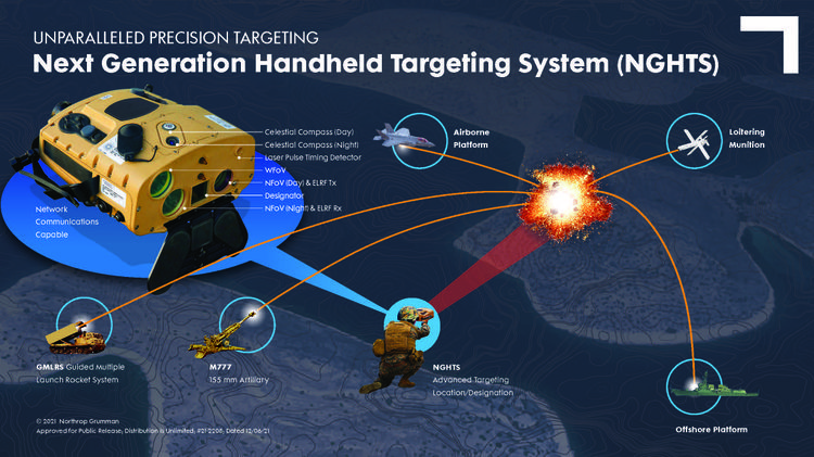
The U.S. Marine Corps has selected Northrop Grumman Corp. to provide it with the Next Generation Handheld Targeting System (NGHTS), a compact device that provides high precision targeting and can operate in GPS-denied environments.
The laser-based device will give Marines an enhanced capability to identify and designate targets from extended ranges, enabling them to identify ground targets under a wide range of conditions.
NGHTS can perform rapid target acquisition, laser terminal guidance operation and laser spot imaging functions. Its high-definition infrared sensors provide accuracy and grid capability over extended ranges.
Additional features include a high-definition color display and day/night celestial compasses.
The U.S. Marine Corps has selected Northrop Grumman to provide the Next Generation Handheld Targeting System (NGHTS), a compact device that provides precision targeting and is capable of operation in GPS-denied environments.
The laser-based device will give marines an enhanced capability to identify and designate targets from extended ranges.
“NGHTS will significantly enhance the ability of marines to identify ground targets under a wide range of conditions,” said Bob Gough, vice president, navigation, targeting and survivability, Northrop Grumman. “Connected to military networks, NGHTS can provide superior situational awareness and accurate coordinates for the delivery of effects from beyond the line of sight.”
Northrop Grumman’s NGHTS is capable of performing rapid target acquisition, laser terminal guidance operation and laser spot imaging functions. Its high-definition infrared sensors provide accuracy and grid capability over extended ranges. Additional features include a high-definition color display and day/night celestial compasses.
Space Systems Command, together with United Launch Alliance and other mission partners, successfully placed the fifth and sixth Northrop Grumman-built Geosynchronous Space Situational Awareness Program (GSSAP)-5/-6 satellites into orbit for the U.S. Space Force, after an on-time launch aboard an Atlas V rocket from Space Launch Complex (SLC)-41 at Cape Canaveral Space Force Station, Florida, at 2 p.m. EST (11 a.m. PST).
“The evolving threat to our space environment requires new levels of resiliency and survivability, autonomy and automation, and unprecedented levels of integration and networking,” said Lt. Gen. Michael A. Guetlein, commander of Space Systems Command. “Today’s successful launch will enhance our capabilities in space domain awareness and our space-based space domain awareness architecture. Congratulations to the USSF-8 integrated team and all mission partners on a successful launch.”
The GSSAP-5/-6 satellites join a constellation supporting U.S. Space Command’s space surveillance operations as a dedicated Space Surveillance Network sensor.
GSSAP also supports the Combined Force Space Component Command by collecting space domain awareness data, allowing for more accurate tracking and characterization of manmade orbiting objects. GSSAP is led by SSC’s Special Programs directorate.
The National Security Space Launch (NSSL) mission launched aboard ULA’s Atlas V in the “511” configuration, which was comprised of a five-meter diameter payload fairing from RUAG Space, a single Graphite Epoxy Motor (GEM)-63 solid rocket booster from Northrop Grumman, and a single RL-10 engine from Aerojet Rocketdyne on the Centaur upper stage.
SSC’s Launch Enterprise acquired the launch service through ULA and was responsible for successfully placing the GSSAP satellites on orbit.
The NSSL program provides assured access for the United States’s critical warfighting space assets, and this launch vehicle has reliably placed valuable assets into their intended orbits repeatedly, adding to the NSSL program’s success record of 88 consecutive launches. The program supports a full range of government mission requirements for the nation’s defense and intelligence sectors.
Space Systems Command is the U.S. Space Force field command responsible for rapidly identifying, prototyping and fielding resilient space capabilities for joint warfighters. SSC delivers sustainable joint space warfighting capabilities to defend the nation and its allies while disrupting adversaries in the contested space domain. SSC mission areas include launch acquisition and operations; space domain awareness; positioning, navigation and timing; missile warning; satellite communication; and cross-mission ground, command and control and data.
A ULA Atlas V rocket carried the USSF-8 mission for the U.S. Space Force into orbit, (Photo: ULA)
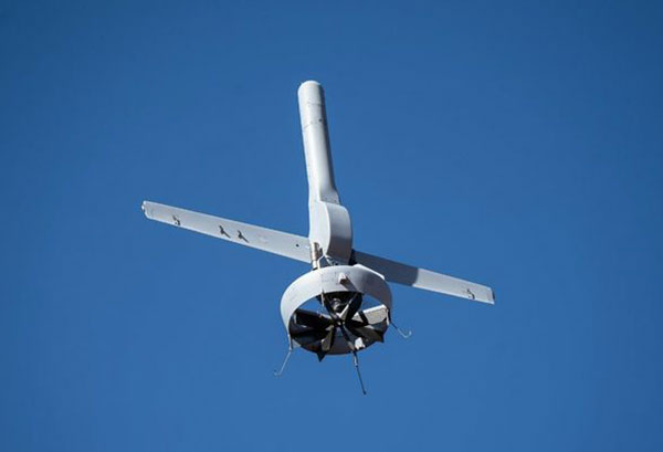
Northrop Grumman and Martin UAV (a Shield AI company) have completed successful flight testing of a V-BAT unmanned aircraft system (UAS) with new features including GPS-denied navigation and target designation capabilities.
The enhanced V-BAT’s flexible vertical take-off and landing (VTOL) capability is based on a platform deployed to address the U.S. Army’s Future Tactical Unmanned Aircraft System (FTUAS) mission. For FTUAS, the U.S. Army is seeking a rapidly deployable, GPS-denied navigation-capable, expeditionary VTOL system capable of persistent aerial reconnaissance for U.S. Army brigade combat teams, special forces, and Ranger battalions.
The offering is based on Martin’s UAV V-BAT UAS. According to Northrop Grumman, it is compact, lightweight, simple to operate, and can be set up, launched and recovered by a two-soldier team in confined environments. The V-BAT also is designed with sufficient payload capacity to carry a range of interchangeable payloads, including electro-optical/infrared (EO/IR), synthetic aperture radar (SAR), and electronic warfare (EW) payloads, depending on mission-specific requirements. Additionally, Shield AI’s recent acquisition of Martin UAV will enable rapid development of GPS-denied and autonomy capabilities for V-BAT through the future porting of Shield AI’s autonomy stack, Hivemind, onto V-BAT.
Northrop Grumman and Martin UAV conduct flight testing of Martin UAV’s V-BAT aircraft for the U.S. Army’s Future Tactical Unmanned Aircraft System effort in Camp Grafton, North Dakota. (Photo: Northrop Grumman)
Spirent Federal Systems, a provider of PNT/GNSS test equipment, announced plans to fully validate the inertial interface between Spirent GNSS simulators and both Northrop Grumman legacy and modernized inertial systems under the EGI‐M program.
For years, Spirent Federal has developed inertial interface test tools in collaboration with Northrop Grumman that yield repeatable, accurate results.
Northrop Grumman’s embedded GPS/inertial navigation system (INS)‐modernization, or EGI‐M, program is developing airborne navigation capabilities with a government‐owned open architecture. The fully modernized system integrates new M‐code capable GPS receivers, provides interoperability with civil controlled air space, and implements a new resilient time capability.
“Spirent Federal has long supported testing of the Northrop Grumman family of interfaces,” said Jeff Martin, Vice President of Sales for Spirent Federal, “and our customers have always obtained precise, reliable results. Spirent Federal strives to keep abreast of the newest technology to be ready to meet the needs of industry, and this collaborative effort that includes the EGI‐M program is yet another example. Spirent is an important part of Northrop Grumman’s test solutions and this validation project acknowledges that importance.”
Spirent Federal has been providing tools for testing inertial systems for more than two decades. Available SimINERTIAL interfaces comprise various EGIs and IMUs from manufacturers of inertial sensors, including Northrop Grumman (formerly Litton), Honeywell and Atlantic Inertial Systems, as well as standardized interfaces such as STANAG.
Testing the full operational performance of GPS/inertial systems usually requires expensive and time‐consuming field testing on a moving vehicle. Spirent’s SimINERTIAL system emulates inertial sensor outputs while concurrently simulating GPS RF signals, enabling controlled, repeatable testing of EGIs and reducing the need for field trials.
The Navigation Technology Satellite-3 (NTS-3) program is making major strides in developing a new navigation spacecraft for in-space demonstration. The NTS-3 is scheduled to launch to geosynchronous orbit from Cape Canaveral in 2023.
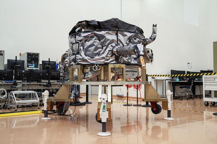
This summer, Northrop Grumman Corp. delivered the ESPAStar-D spacecraft bus to L3Harris Technologies of Palm Bay, Florida.
“The transfer of the bus allows L3Harris to move forward building the NTS-3 spacecraft,” said 2nd Lt. Charles Schramka, the program’s deputy principal investigator. “L3Harris will perform tests and begin integrating the NTS-3 PNT payload onto the bus. Together the bus and payload will form the NTS-3 spacecraft.”
Following L3Harris’s work, the Air Force Research Laboratory (AFRL) will test the bus with the NTS-3 ground control and user equipment segments, and will perform its own integrated testing on the overall NTS-3 system architecture.
Northrop Grumman has successfully delivered an ESPAStar-D spacecraft bus to L3Harris in support of the NTS-3 mission. (Photo: U.S. Air Force)
NTS-3 in the Vanguard. In 2019, the U.S. Air Force designated NTS-3 as one of three Vanguard programs — priority initiatives to deliver new capabilities for national defense. The NTS-3 mission is to advance technologies to responsively mitigate interference to position, navigation and timing (PNT) capabilities, and increase system resiliency for GPS military, civil and commercial users.
“This is the first time an ESPAStar bus has been built and delivered as a commercially available commodity,” said Arlen Biersgreen, NTS-3 program manager. “NTS-3 is using a unique acquisition model for the ESPAStar line that fully exercises the commercial nature of Northrop Grumman’s product line, in order to provide the bus to another defense contractor for payload integration using standard interfaces.”
The ESPAStar-D bus, built in Northrop Grumman’s satellite manufacturing facility in Gilbert, Arizona, includes critical subsystems such as communications, power, attitude determination and control, in addition to configurable structures to mount payloads.
The bus will “provide affordable, rapid access to space,” according to Northrop Grumman. Its configuration, using an Evolved Expendable Launch Vehicle (EELV) Secondary Payload Adapter (ESPA), allows multiple separate experimental payloads to be stacked together on one launch vehicle. AFRL developed the ESPA ring to transport space experiments, allowing for lower cost and more frequent trips to space for government and industry users.
Besides the bus delivery, there are other advances in the program.
GNSSTA receiver. In June, AFRL took delivery of an experimental receiver — GNSS Test Architecture (GNSSTA). The receiver was developed by the AFRL unit the Sensors Directorate, located at Wright-Patterson Air Force Base in Ohio, and Mitre Corporation. GNSSTA is a reprogrammable software-defined signal receiver that will allow the Air Force to receive both legacy GPS and advanced signals generated by NTS-3.
AFRL will continue its integration efforts through 2022 to ensure all parts are working together for the fall of 2023 NTS-3 launch.
“With the delivery of the bus we are entering into the next phase of payload integration,” Biersgreen said. “These recent breakthroughs allow the program to continue to move forward and prepare for launch of the first U.S. integrated satellite navigation experiment in over 45 years.”
Artist’s concept for NTS-3 in geostationary orbit. (Artist’s concept: 2d Lt. Jacob Lutz, AFRL)
While GPS will always be an integral and irreplaceable part of positioning, navigation and timing (PNT) technology, assured PNT must take a layered approach for true resiliency.
A GPS World webinar sponsored by Spirent Federal Systems will explore this topic. Registration is now open for the free webinar, which will be held June 24.
Join experts from Spirent and Northrop Grumman as they examine
the future of inertial navigation in assured PNT and GPS augmentation
EGI-Modernization
coherent GNSS and inertial sensor emulation
exploring and simulating emerging alternative space-based PNT RF signals.
Expert presentations will be followed by a question-and-answer session; questions will be accepted both before and during the webinar.
To register for the webinar, visit this link. Registration is free.
Date: Thursday, June 24, 2021 Time: 1 p.m. EDT / 10 a.m. PDT / 7 p.m. (1900h) Central European Time Duration: 60 minutes + extra time for Q&A Sponsored content by: Spirent Federal
Jennifer Smith joined Spirent Federal in 2004. Jen has responsibilities in business development as well as in general operations. She has experience in project management and contract negotiations.
Smith has a B.A. and a J.D. and is a member of the Utah Bar Association.
Naveen Joshi leads the Strategy and Business Development for Northrop Grumman’s Navigation and Integrated Cockpit business. He sets product strategy, shapes technology roadmaps, and advises Northrop Grumman leaders on the application of PNT technologies. His previous roles at Northrop include program director, program manager, engineering manager and various roles in engineering.
Outside of Northrop Grumman, Joshi held roles in management consulting and eCommerce, and ran an entrepreneurial venture.
Joshi earned a bachelor’s degree in computer science from Cornell University and an MBA from UCLA’s Anderson School of Management.
Mark Holbrow’s 30-year professional career has concentrated on the innovative design, development, and successful commercialization of electronic test equipment.
In his current role, he is responsible for the technical team management, new product design, and future direction of Spirent’s portfolio of world-leading positioning, navigation, and time (PNT) test solutions.
Holbrow has a passion for the sometimes overlooked discipline of “test methodology” and thoroughly enjoys the technical and business development demands required to identify, and innovatively solve, complex test challenges.
Roger Hart joined Spirent Federal in 2015. Roger has responsibilities in engineering development and support, sales and customer training. He has worked in development of spacecraft navigation systems, including GPS, for civil, NASA and defense applications since 1986.
Hart has a Bachelor of Arts in physics and Master of Science in mechanical engineering (space track) from Utah State University.
To register for the webinar, visit this link. Registration is free.
Bernard Gruber, who previously headed the GPS program for the United States Air Force, has joined the GPS World Editorial Advisory Board.
Gruber is senior director of Guided Projectiles and Precision Weapons, Innovation Systems, at the Armament Systems Division of Northrop Grumman in Plymouth, Minnesota. In this role, he is responsible for the capture and program execution of multiple U.S. Department of Defense and global programs within five business lanes:
Precision Guidance Kits
Advanced Weapons
Barriers/Area Denial Systems
Air Defense/Counter-Unmanned Aircraft Systems (C-UAS)
Air-to-Ground Precision Weapons
Gruber joined Northrop Grumman (then ATK) in September 2013, where he was responsible for winning and managing cost, schedule and technical performance of a significant international co-production program before moving on to deputy for precision weapons and then senior director in 2015.
Before joining Northrop Grumman, Gruber completed a distinguished 26-year Air Force career and retired as the program director of the Global Positioning System (GPS), Los Angeles Air Force Base. As GPS director, he was responsible for development, acquisition, fielding and sustainment of all GPS satellites, command and control (ground segment) and military user equipment.
The $32 billion GPS program, with a $1 billion annual budget and 700 member team, maintained the largest satellite constellation and the largest avionics integration and installation program in the entire DOD.
Gruber earned his B.S. in mechanical engineering from North Dakota State University and his M.B.A. from Michigan. He is a graduate of Squadron Officer School, Air Command and Staff College, Air War College, Defense Systems Management College and the Joint Forces Staff College; he has commanded at the squadron, group and wing levels.
Gruber has distinguished himself in a variety of leadership positions within the operations, intelligence, launch, engineering and acquisition disciplines, and had served in key positions at Major Command, Air Staff, Joint Staff, Corporate and Defense Agency levels. He is a National Defense Fellow, life member of the Air Force Association, National Eagle Scout Association, Program Management Institute and sits on the board of directors for AirSpace Minnesota and the Midwest Defense Alliance.
Northrop Grumman is a global security company providing innovative systems, products and solutions in autonomous systems, cyber, C4ISR, strike and logistics and modernization to customers worldwide.
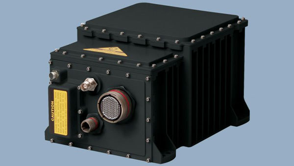
Northrop Grumman Corporation has successfully completed the critical design review (CDR) milestone for the Embedded Global Positioning System/Inertial Navigation System (INS)-Modernization, or EGI-M, program.
EGI-M provides state-of-the-art airborne navigation capabilities with an open architecture that enables rapid responses to future threats. The fully modernized system integrates new M-code capable GPS receivers, provides interoperability with civil controlled air space, and implements a new resilient time capability.
“The completion of this milestone is a key step in bringing necessary navigation capability upgrades to our warfighters,” said Brandon White, vice president, navigation and positioning systems, Northrop Grumman. “With its open architecture and government ownership of the key internal interfaces, EGI-M’s next-generation navigation solution allows the government to quickly insert emerging capabilities from third parties while maintaining cyber security and airworthiness.”
The F-22 is one of the lead platforms for EGI-M integration. (Photo: Staff Sgt. Carlin Leslie/U.S. Air Force)
Northrop Grumman’s unique, modular platform interface design enables backwards compatibility with existing platform footprint and interfaces (A-Kits), allowing current platforms to easily integrate and deploy Northrop Grumman’s EGI-M solution.
At the same time, EGI-M’s modular software and hardware, coupled with government ownership of key interfaces, allows EGI-M to benefit from rapid upgrades with best of breed software and hardware technologies now and in the future.
Northrop Grumman has been on contract for the engineering and manufacturing development (EMD) phase of EGI-M since November 2018. The CDR milestone marks the completion of detailed hardware and software design of the EGI-M product line.
The launch platforms for Northrop Grumman’s EGI-M are the F-22 fighter jet and E-2D early warning aircraft. Additional fixed-wing and rotary-wing platforms across Department of Defense and allied forces have already selected Northrop Grumman’s EGI-M as their future navigation solution.
The E-2D Hawkeye is an American all-weather, carrier-capable tactical airborne early-warning aircraft. (Photo: U.S. Navy)