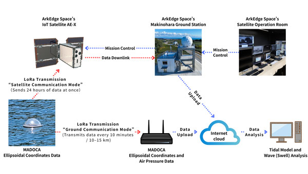
ArkEdge Space Inc. has been selected for Japan’s fiscal 2025 QZSS Utilization Demonstration Project. The initiative is jointly organized by Japan’s Cabinet Office and Quasi-Zenith Satellite System Service Inc.
The company will deploy next-generation tide monitoring buoys across island nations in the Asia-Pacific region. The buoys will use MADOCA-PPP, a high-precision GNSS augmentation service provided by Japan’s Quasi-Zenith Satellite System known as Michibiki. The devices will collect sea level data and transmit information through ArkEdge Space’s Internet of Things satellites.
ArkEdge Space specializes in designing, developing and operating micro-satellites while integrating communications technologies including IoT and VDES (VHF Data Exchange System) for observation and positioning applications. The company plans to use this demonstration project to address challenges in developing regions related to disaster preparedness, tsunami and storm surge monitoring, port infrastructure development and climate change adaptation.
Field operations are scheduled to begin in November 2025. The company plans to host a regional seminar at the Asia-Pacific Regional Space Agency Forum. Additional announcements regarding buoy deployment and project updates will be made separately.
The project aims to promote global adoption of Japan’s Michibiki satellite positioning technology and advance sustainable marine observation infrastructure using IoT-enabled satellite services.
The QZSS Utilization Demonstration Project is a public initiative conducted by Japan’s Cabinet Office and Quasi-Zenith Satellite System Service Inc. to promote early adoption of commercial services and products using Japan’s QZSS Michibiki system.
MADOCA-PPP is a real-time high-precision positioning augmentation service developed by Japan’s Cabinet Office and the Japan Aerospace Exploration Agency. The service delivers centimeter-level accuracy of 10 centimeters or less both horizontally and vertically via the L6 signal of the Michibiki constellation and is compatible with multi-GNSS receivers.
VDES is a next-generation maritime communication system that extends the functionality of the Automatic Identification System to enable high-speed, bidirectional data exchange. In Japan, ArkEdge Space is part of the Satellite VDES Consortium with IHI Corporation and Japan Radio Co. Ltd. In July 2025, the company launched a test satellite and began in-orbit demonstrations of VDES technology.
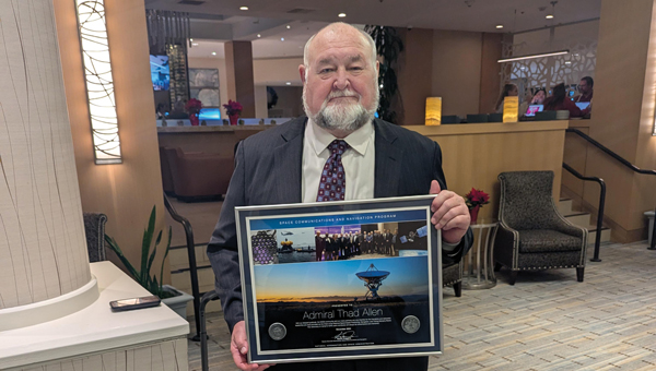
The National Space-Based Positioning, Navigation, and Timing Advisory Board continued its discussions on how best to protect, toughen and augment GPS at its 31st meeting, which took place Dec. 4-5 at the Sonesta Redondo Beach and Marina in Redondo Beach, California. The meeting was convened by James J. Miller, of NASA, who is the board’s executive director, and chaired by retired Adm. Thad Allen of the U.S. Coast Guard.
On the first day, after hearing reports from its six subcommittees, the board heard the following presentations:
Karen Van Dyke, director, PNT & spectrum management, Department of Transportation (DOT), on DOT’s IDM and complementary PNT work.
Maj. Christine Bonniksen, retired from the U.S. Air Force, deputy director for flight projects, NASA Langley Research Center, and Shachak Pe’eri, Ph.D., acting director, National Geodetic Survey, National Ocean Service, National Oceanic and Atmospheric Administration (NOAA), on NOAA’s implementation of a GDGPS-based GPS High Accuracy and Robustness Service.
Anh Nguyen, Ph.D., NASA flight opportunities program (Bryce Space and Technology, LLC) and Lisa Valencia, NASA Space Communications and Navigation Program (Overlook Systems Technologies, Inc.) on the SpaceLoft 15 multi-GNSS flight experiment (see the article on p. 16).
Allison Kealy, Ph.D., director of the Innovative Planet Research Institute, Swinburne University, Australia, on resilient PNT.
Brad Parkinson, Ph.D., the board’s first vice chair, on a comparison of GPS with the other GNSS.
Satoshi Kogure, senior chief officer of satellite navigation technology, Japan Aerospace Exploration Agency on Japan’s Quasi-Zenith Satellite System (QZSS).
Moon Beom Heo, Ph.D., executive director of KPS R&D Directorate, Korea Aerospace Research Institute on the Korean Positioning System (KPS).
Matt Higgins, international engagement subcommittee chair on Galileo.
Cordell DeLaPena, executive officer, MilComm & PNT, Space Systems Command, USSF on the status of the GPS program, including L5, OCX, civil signal monitoring, resilient-GPS and low-Earth orbit PNT.
On the second day, the board held a roundtable discussion, then heard updates from its international members and representatives. For video of the proceedings, go to youtube.com/@nationalpntboardmeetings822/streams.
To celebrate Allen’s long service as this board’s chair, NASA conferred a beautiful plaque to him, bearing the following text:
“PRESENTED TO Admiral Thad Allen
With our deepest gratitude, the NASA community and our many partners are very thankful for the friendship and dedicated leadership you have provided as the Chair of the National Space-Based Positioning, Navigation, and Timing Advisory Board. Your advocacy on behalf of GPS users worldwide will always be remembered and cherished. December 2024
Kevin Coggins
Deputy Associate Administrator, Space Communications and Navigation
NATIONAL AERONAUTICS AND SPACE ADMINISTRATION”
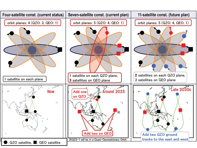
Japan’s Cabinet Office (CAO) is currently developing the Quasi-Zenith Satellite System (QZSS) seven-satellite constellation (7SV-const.)
Japan’s cabinet revised our new basic space policy plan on June 13, 2023. It states that the number of QZSS satellites should be increased from seven to 11 to improve stability and reliability as one of the social infrastructures by securing backup function for coming full-scale use and to reduce the dilution of precision (DOP).
On June 12, 2024, the National Space Policy Secretariat revised the action plan for the satellite positioning system for the first time in three years. According to this plan, the completion of the QZSS 11-satellite vehicle constellation is anticipated by the late 2030s.
Figure 1 System expansion of QZSS.
Brief History of QZSS
Since 2006, the Ministry of Education, Culture, Sports, Science and Technology (MEXT), the Japan Aerospace Exploration Agency (JAXA), the Ministry of Internal Affairs and Communications (MIC), the Ministry of Economy, Trade and Industry (METI) and the Ministry of Land, Infrastructure, Transport and Tourism (MLIT) have collaborated to develop the world’s first centimeter-level positioning satellite.
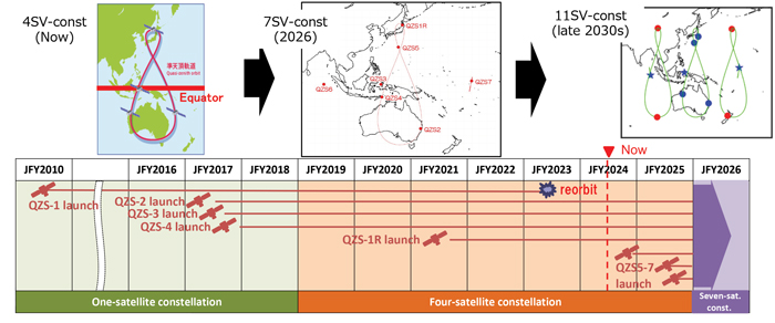
The first QZS satellite was launched in September 2010, for what was then envisioned as a four-satellite regional satellite navigation system, also known as MICHIBIKI. In September 2011, the Cabinet approved a plan to build the four-satellite constellation (4SV-const.) in the late 2010s, with the goal of building a 7SV-const. in the future. The budget was approved in JFY2012 to promote this as a national project.
In 2017, QZS-2, 3 and 4 were successfully launched and a 4SV-const. was established. On Nov. 1, 2018, QZSS officially began service. On Oct. 26, 2021, the successor to the first MICHIBIKI was launched.
Development is underway to launch three additional satellites for the 7SV-const. sequentially from JFY2023 to JFY2024, depending on the development status of the H3 launch vehicle.
To improve resilience for more stable positioning and improved DOP, CAO has started a study to transition from a 7SV-const. to an 11SV-const. (See Figures 1 and 2)
Figure 2 QZSS Constellation Expansion Plan.
Service Overview
The 4SV-const. provides GPS Complementary Service (PNT service); GNSS Augmentation Service, i.e. Sub-meter Level Augmentation Service (SLAS), Centimeter Level Augmentation Service (CLAS), MADOCA-PPP and satellite-based augmentation service (SBAS), as well as a messaging service.
The QZSS constellation consists of a geostationary orbit (GEO) satellite, QZS-3 and three QZO satellites.
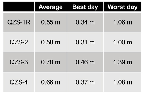
QZSS’s performance of the positioning, navigation and timing (PNT) service and signal-in-space user range error (SIS-URE) was much better than specified. Evaluation results are shown in Table 1.
The evaluation period was “08/01/2023#07/31/2024.” The specification is less than 2.6 m (95%).
Toward Seven-Satellite Constellation
Three additional satellites will be positioned in an inclined geostationary synchronous orbit (IGSO) at 90.5° east longitude and in a quasi-geostationary orbit at 175° west Longitude. This constellation is designed to ensure that multiple satellites are visible at high elevation angles, with the goal of having more than four satellites visible for extended periods of time, ultimately improving the DOP.
The positioning signals of 7SV-const. are shown in Table 2. QZS 5 to 7 transmit L1C/B.
Table 1 Performance of the QZSS PNT service.
After the QZS-5 service starts, QZS1R’s signal will switch from L1C/A to L1C/B. The QZSS Navigation Message Authentication (QZNMA) service for other GNSS is included in L6E signals.
QZS5-7 development is ongoing. A system-level test is in progress. The plan is to launch QZS 5-7 around 2025. QZS-5 and 6 have almost finished the system-level test. QZS-7 finished the electrical test, and now it is in the environmental test phase.
QZSS antenna patterns for SSV users, published since Aug 2023, correspond to the ICG WG-B recommendation “Release of GNSS Transmit Antenna Patterns Including Side Lobes,” submitted on Dec. 11, 2019.
The QZSS ground system, capable of operating with seven satellites, was completed in August 2023. The only remaining task is to conduct compatibility tests between the satellites and the ground radio frequency. The QZSS ground system consists of two master control stations located in Hitachi-Ota and Kobe, as well as 10 satellite tracking and control stations (telemetry, tracking and command stations), primarily situated in the southwestern islands. Additionally, there are more than 30 monitoring stations worldwide, established in cooperation with various countries.
The following additional services began this year or will begin next year:
Users obtain position, velocity, and time (PVT) solutions using ranging signals provided by the 7-SV const. The Navigation Message Authentication (NMA) began in April 2024.
Multi-GNSS Advanced Orbit and Clock Augmentation — Precise Point Positioning (MADOCA-PPP) covers a major part of the Eastern Hemisphere and provides PPP error corrections on the L6 signal. It enables highly precise positioning by providing augmentation data to correct some GNSS errors and provides two service levels, i.e., (a) global-PPP and (b) fast-PPP with ionospheric correction.
Operational service started on April 1, 2024 and Internet distribution of MADOCA-PPP in July 2024.
Expanded Satellite Report for Disaster and Crisis Management (DC report), Early/Emergency Warning Satellite Service (EWSS).
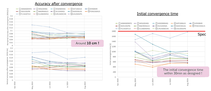
Figure 3 MADOCA-PPP service evaluation results.
In addition to the current DC report service generated by the Japan Meteorological Agency, other disaster-related reports, called L-alert and J-alert, such as an evacuation order, began on April 1, 2024.
The Global PPP service provides highly precise positioning where QZSS L6E signals can be received.
It provides satellite-dependent error corrections (orbit, clock, code/phase bias) by QZSS L6E signals.
Faster PPP using observation data from regional/nationwide Continuously Operating Reference Stations (CORS). In addition to global PPP, QZSS L6D (QZS-6 and 7) signals will provide regional error corrections (ionospheric correction).
MADOCA-PPP began operational service on April 1, 2024. For MADOCA’s stable operation, the GNSS Integrated Data Sharing System (MIRAI) was released in April 2022. The ionospheric correction data will be broadcast to reduce the initial convergence time starting in 2025.
MADOCA-PPP service was defined and described on PS-QZSS 003, published on March 17, 2022. Internet distribution of MADOCA-PPP, including ionospheric correction data, began in July 2024 to promote MADOCA-PPP utilization. MADOCALIB, test library of MADOCA-PPP, has been open-sourced and made available on GitHub this April, and updated to process ionospheric correction data in July 2024. MADOCA-PPP performance results from May to August 2024 using IGS monitoring station are shown in Figure 3.
Better initial convergence time than the defined specification and approximately 10 cm of accuracy are confirmed.
Thanks to the cooperating countries, ionospheric correction data can be generated, and the initial convergence time reduction was confirmed in all areas.
CAO started the Internet distribution, including the ionospheric correction data for these areas.
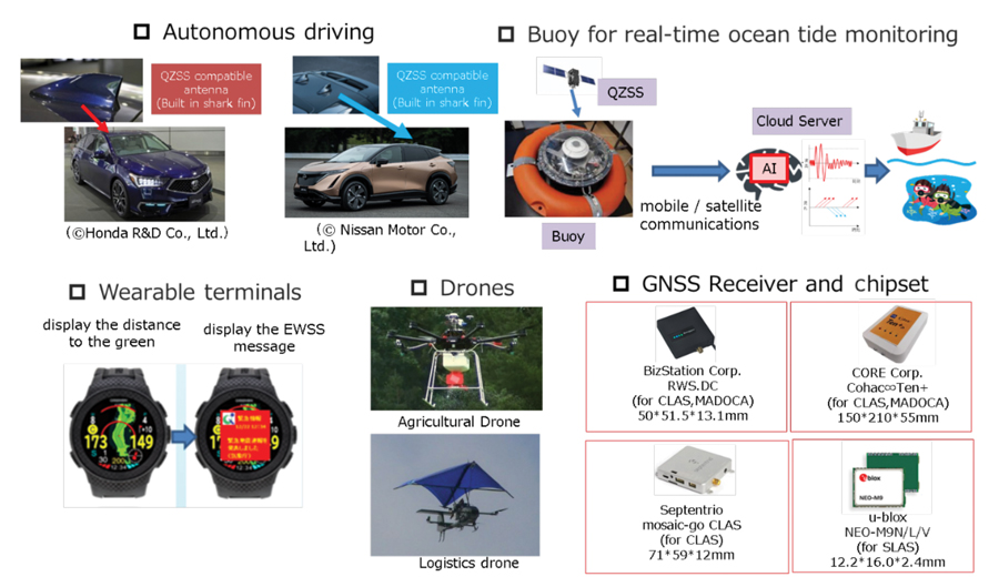
Figure 4 QZSS applications.
QZNMA
QZNMA began on April 1, 2024, to enhance the constellation’s resilience against spoofing attacks.
Navigation messages in the following signals are authenticated using the Elliptic Curve Digital Signature Algorithm (ECDSA P256).
■ QZSS signals (L1C/A(C/B), L1C, L5) are directly protected by self-authentication.
■ GNSS signals (GPS: L1C/A, L1C, L5, Galileo:E1b, E5a) are protected by cross-authentication (L6E).
As of September 2024, approximately 434 products are compatible with QZSS (See Figure 4). New applications such as autonomous driving, drone operations and buoys for real-time ocean tide monitoring are emerging. We expect that many applications and devices using QZSS will emerge. We appreciate your cooperation and support of QZSS.
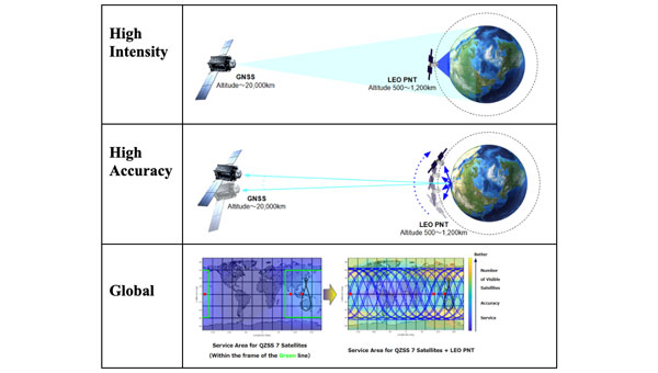
The Japan Aerospace Exploration Agency (JAXA) has awarded Japanese startup ArkEdge Space a contract to study the feasibility of establishing a constellation of positioning, navigation and timing (PNT) satellites in low-Earth orbit. The project aims to provide high-precision PNT signals across the globe.
Government agencies worldwide are exploring ways to complement and back up GNSS, which is susceptible to natural and deliberate interference. In addition, self-driving cars and autonomous drones require extremely precise location data.
Under the new JAXA contract, ArkEdge Space will provide a conceptual design for a LEO-PNT satellite and its orbit. ArkEdge will also explore satellite and constellation tradeoffs and consider different signal formats and frequency bands.
With a new LEO-PNT constellation, JAXA seeks to expand the coverage area of service currently provided by Japan’s geostationary Quasi-Zenith Satellite System (QZSS) satellites.
Under a separate JAXA contract, ArkEdge is developing positioning and communications services for cislunar space.
Current state of the art multi-frequency GNSS receivers operate by receiving L1 first and then L5. L5-first is a viable answer to the call for more resilience in GNSS as is being discussed in government and technical circles to protect vital national infrastructure. It is suggested as part of “Toughening Category 4: Signal Alternatives” to protect, toughen and augment (PTA) the current GNSS systems described by Brad Parkinson’s article in the March 2022 issue of GPS World.
Paul McBurney
The need arises from attacks directed by bad actors on a large scale, such as electronic warfare, and on a more humane scale, by bad actors such as self-jammers and spoofers. On top of that, normal interference can cause desensitization and denial of service on GNSS receivers from myriad terrestrial and satellite communications.
The PTA plan presents the Denial Radius Reduction Ratio (DRRR) figure of merit and shows that a J/S increase of 15 dB produces a DRRR of 0.18. Whereas a receiver without this additional 15 dB of J/S could be denied fixing out to 1 km from a given transmitter, a receiver with an additional 15 dB J/S would be denied out to only 180 m from the same transmitter.
The improvement in terms of area is proportional to radius squared. The article identifies that the J/S capability is different among GNSS signals and the best performance is obtained with L5, mainly because it has the highest chipping rate. L1C has a code length of 10,230 chips, the same as L5, but it is spread over 10 msec and has the same chipping rate as L1 C/A.
There are currently 72 L5 signals between GPS, Galileo, BeiDou and QZSS transmitting the same physical layer features of 10.23 MHz chipping rate, 1 kHz overlay codes and higher transmit power compared to nearly all L1 signals with a 1.023 MHz chipping rate and lower transmit power. The combination of these features at L5 is close to achieving this 15 dB performance level over L1.
Unlike current hybrid receivers, L5-first survives L1 jamming. (Photo: Carkhe / iStock / Getty Images Plus / Getty Images)
One might conclude that the current start of the art of a receiver with both frequencies (aka, a hybrid L1+L5) has this resilience. However, the market does not currently offer the ability to directly acquire L5 signals overall use cases of GNSS assistance without first acquiring signals at L1. This means they can only achieve this resilience when the interference is encountered after acquiring and fixing at L1. As soon as the L1 is lost and the position and time uncertainty grow beyond the receiver’s capacity to autonomously search for L5 signals, the receiver is denied service at the interference level tolerable at L1. If you cut the receiver into L1 and L5 pieces, only the L1 side is capable of fixing autonomously. As noted by Dennis Akos et al. (“Testing COTS GNSS Receivers Using Only a Subset of Supported Signals,” ION JNC 2023), “support for several signals/frequencies provides integrity and robustness.” Specifically, “under jamming scenarios, signal diversity can allow a receiver to still generate an accurate position solution.”
Current receivers are not able to acquire L5 for reasons related to history, cost and power consumption. Historically, the promise of L5 accuracy was so attractive that it was added to legacy chipsets based on L1 even when it was only partially deployed. It was impractical at that time to require L5 acquisition when there were fewer L5 satellites than at L1. Cost and power are related to the fact that L1 receivers’ acquisition methods are sized to acquire the L1, E1, B1 and G1 signals. Memory and compute capacities, including the digital clock speed, are sized for slower chipping rates and hence shorter code lengths. At this performance level, conventional time domain correlation is adequate. Some receivers deploy frequency domain methods at L1 and achieve a lower cost and power than time domain methods with similar capacity. However, the L5 acquisition complexity with time domain correlation is 100 times more than L1 as its complexity increases with N2, meaning the cost and power to acquire L5 is out of reach. While using a time domain acquisition engine to acquire L5 may be possible for strong signals when the code and frequency search space is constrained for those signals, directly acquiring L5 with conventional methods would have serious shortcomings in many use cases.
Interestingly, the signal designers across all GNSS systems have cleverly designed the L5 signals so they can be easily acquired after acquiring their counterparts on L1. The L5 primary and secondary code is predictable based on learning the L1 primary code and navigation data bit phase. E5a and B2a primary and secondary codes can be predicted by learning the well-designed E1/B1 primary and secondary code phases that have the same total period: the combination of the 4 msec code lengths synchronous with 25 bits of secondary code are in phase with the E5a 100 msec overlay code. After an L1 fix with fine time, L5 can similarly be directly acquired easily with limited searching.
Four T300’s from ComNav Technology have been used as active control GNSS points on the top of Sweden’s tallest building, Karlatornet, during its construction to deliver 3D coordinates to total stations and one was used as a base station. The building is set to be complete this month.
The T300 is a receiver with radio frequency, a baseband chip built in, and a unique quantum-real-time kinematic (RTK) algorithm. It supports full constellation systems including BDS-2, BDS-3, GPS, GLONASS, Galileo, QZSS and NavIC.
The receiver is designed for demanding surveying tasks, features tilt compensation, 4G/Wi-Fi connection, 8-GB internal memory and an easy survey workflow with Android-based Survey Master Software. It is designed to make collecting accurate data easy and fast, whether done by a beginner or experienced professional surveyor, the company said.
Space Systems Command (SSC) has successfully delivered the second and final spaceflight-ready payload to Japan, bolstering the contribution by the U.S. Space Force (USSF) to integrated deterrence in the region.
The two USSF payloads, developed by MIT Lincoln Laboratories, will be hosted on Japan’s GEO-based Quasi-Zenith Satellite System (QZSS). The deliveries of both payloads to Japan follows a Memorandum of Understanding signed between the two nations in December 2020.
This effort aims to demonstrate the ability of the U.S.-Japan alliance to extend to space; contribute toward the Department of Defense’s broader integrated deterrence posture against shared adversaries in the Indo-Pacific theatre; contribute to the USSF’s Space Domain Awareness; and provide a basis for future opportunities with international partners.
The hosted payloads will augment the USSF’s ability to conduct persistent, time-dominant volume search at geosynchronous orbit. Launch dates for the host satellites, QZS-6 and QZS-7, have not yet been announced.
CHC Navigation has released the NX510 SE Auto-Steer, an automated steering system that retrofits several types of new and old farm tractors and other vehicles. It can be connected to local real-time kinematic (RTK) networks or GNSS RTK base stations.
NX510 SE is a guidance controller powered by multiple corrections sources and five satellite constellations: GPS, GLONASS, Galileo, BeiDou and QZSS. It has a built-in 4G and UHF modem that connects to all industry-standard differential GPS and RTK corrections to achieve centimeter-accuracy steering.
NX510 SE contains GNSS and inertial navigation system terrain compensation technology, which maintains high accuracy in challenging environments and terrain. This makes NX510 SE suitable for ditching, planting and harvesting applications.
In addition, AgNav multilingual software, operating on a 10.1 in industrial display, supports multiple guideline patterns that include AB line, A+ line, circle line, irregular curve and headland turn.
The U.S. Space Force (USSF) has delivered two payloads to Japan for the Quasi-Zenith Satellite System (QZSS). The payloads will be integrated into two QZSS host satellites being prepared for launch, which will expand the QZSS constellation from five to seven satellites.
The QZSS hosted payload (QZSS-HP) is central to the USSF priority of expanding cooperation to contribute to international security. The mission is managed by the Space Domain Awareness and Combat Power Directorate (SDACP) of the Space Systems Command (SSC) within the USSF.
Massachusetts Institute of Technology’s Lincoln Laboratories (MIT/LL) is the primary payload developer for the QZSS-HP. MIT/LL and USSF personnel will travel to Japan to support the integration and test efforts with Japanese partners until both QZSS host satellites are launched.
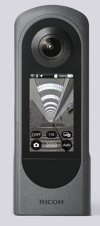
The Ricoh Theta X 360° camera uses a u-blox module for its location metadata. (Photo: Ricoh)
The ZOE-M8B GNSS module from u-blox is integrated into the new RicohTheta X camera. The camera allows users to shoot high-quality 360-degree spherical images and videos in one click and visualize them immediately on an LCD touch panel.
The u-blox ZOE-M8B enables the Ricoh Theta X’s built-in location system, one of its key features. The module is listed on the u-blox site as receiving GPS, BeiDou and GLONASS signals as well as QZSS, but the Ricoh Theta X specifications list only GPS + QZSS along with assisted GPS.
The u-blox receiver automatically embeds highly accurate location information for each image taken, without the need for a smartphone or another external device.
An icon on the LCD touch panel displays the availability of the GPS signals depending on the user’s location, ensuring the location information has been reliably acquired before shooting begins. The location is accurate down to a 5-meter radius, suitable for a wide range of industrial and consumer applications.
The u-blox ZOE-M8B GNSS module is an ultra-small (4.5 mm x 4.5 x 1.0 mm) system-in-package offering highly accurate positioning with concurrent reception of up to three satellite constellations. The Super-E (Super-Efficient) mode guarantees power consumption as low as 12 mW, and built-in SAW and LNA make it suitable for passive antennas. The u-blox ZOE-M8B targets applications that require a small size without compromising performance.
Part of a 360° spherical image shot with the Theta X. (Photo: Ricoh)
“We chose the u-blox module because of the highly accurate location information it offers, alongside easy integration and low power consumption,” said Kenji Daigo, GPS Function Developer for Theta X at Ricoh.
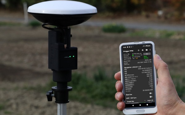
BizStation, a database company based in Japan, and u-blox have announced a highly accurate, compact and low-cost high-precision positioning solution for markets in East Asia and Oceania.
Featuring two u-blox modules, the solution delivers centimeter-level positioning accuracy where mobile network service is unavailable, including in maritime offshore surveying, agricultural and industrial vehicle guidance, and UAVs.
BizStation’s precise point positioning (PPP) system covers all territories served by Japan’s Quasi-Zenith Satellite System (QZSS) MADOCA correction service.
The solution leverages the strengths of two u-blox components. The first, a u-blox ZED-F9P multi-band high precision GNSS receiver module, is at the heart of BizStation’s DG-PRO1RWS GNSS receiver.
The second, a u-blox NEO-D9C correction-data receiver module specific to Japan, enables their virtual reference station to receive data on the QZSS L6E-band used by MADOCA.
The PPM (PPP positioning by MADOCA) Android application developed by BizStation then determines the location of the tracked device using the high-precision positioning data transferred via Wi-Fi from BizStation’s DG-PRO1RWS GNSS receiver as well as GNSS correction data from the virtual reference station. The PPM application performs all required calculations using the MADOCA positioning library developed by NEC Solution Innovators Co., Ltd.
The high-precision GNSS solution can be deployed either using a static or a mobile virtual reference station for a wide range of applications such as agriculture, drones, motor sports or surveying systems.
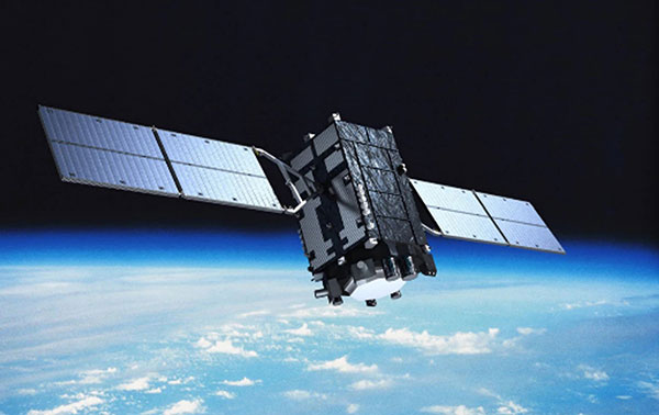
Mitsubishi Electric Corp. has completed initial verification of the functions and performance of equipment aboard the orbiting QZS-1R satellite.
QZS-1R was launched Oct. 26, 2021, from Tanegashima Island in Kagoshima Prefecture and is now in quasi-zenith orbit as the successor to the original Quasi-Zenith Satellite (QZS-1), nicknamed Michibiki.
Logo and patch for the QZS-R1 satellite (Image: Miitsubishi Electric).
With Quasi-Zenith Satellite System services also having completed testing of related ground systems, the Cabinet Office will begin launching various positioning services via the QZS-1R today.
Mitsubishi Electric built and delivered QZS-R1 to the Cabinet Office of Japan. In addition to supporting these services, Mitsubishi Electric will continue developing satellite systems for forthcoming satellites QZS-5 to QZS-7, which will support advanced, sustainable, high-precision positioning in Japan.
Compared to the first Michibiki satellite, the QZS-1R has improved durability that is expected to extend the satellite’s design life by about five years compared to its predecessor. QZS-1R, together with QZS-2, 3 and 4 (all launched in 2017), will support positioning, high-precision positioning augmentation and other satellite services.
Name
QZS-1R
Mass
Dry mass (i.e., without propellant): approx. 1.6 tons; at launch: approx. 4.0 tons
Dimensions
Stowed: approx. 5.4m x 2.9m x 2.9m; wing span: approx. 19m