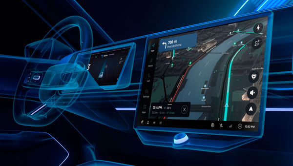
TomTom has launched its Automotive Navigation Application, a navigation solution designed for automakers that combines TomTom Orbis Maps with an enhanced user interface layer built on the company’s Navigation SDK. The company said the integrated solution allows car manufacturers to deploy navigation systems more quickly while reducing development costs and timelines.
The application addresses growing demand in the automotive industry for software-defined vehicles (SDVs), where rapid integration capabilities have become essential for meeting market expectations. TomTom designed the system to help automakers focus on delivering innovative solutions rather than spending extensive resources on navigation development.
The company conducted comprehensive testing of the application on automotive-grade hardware, including end-to-end evaluations performed directly in vehicles. This testing process ensures automakers receive a production-ready application that meets industry quality standards.
The solution provides automakers with three key components: an off-the-shelf navigation application, a user experience library for customizing driver interfaces, and a vehicle integration library with documentation that enables independent connection between vehicles and the application. This structure seeks to streamline the integration process for manufacturers and their partners.
Built on TomTom Orbis Maps, the application uses updated map data designed to provide accurate and reliable navigation information. The system includes dynamic caching functionality that delivers continuous updates, ensuring drivers receive current route information. Automakers can customize the navigation experience to align with their brand identities through the Mapmaker tool, which simplifies the customization process without requiring extensive development time or costs.
The application incorporates 3D visualization and electric vehicle-optimized navigation features. For electric vehicles, the system integrates with the vehicle’s battery status to provide charging stop recommendations. The charging finder feature helps drivers locate charging stations based on their subscriptions and preferences, while advanced filters allow trip planning that includes access to desired amenities along routes.
TomTom continues to offer its standalone Navigation SDK alongside the new application. The SDK has customizable features for in-house developers who prefer to build their own navigation systems, giving manufacturers options based on their specific requirements and development capabilities.
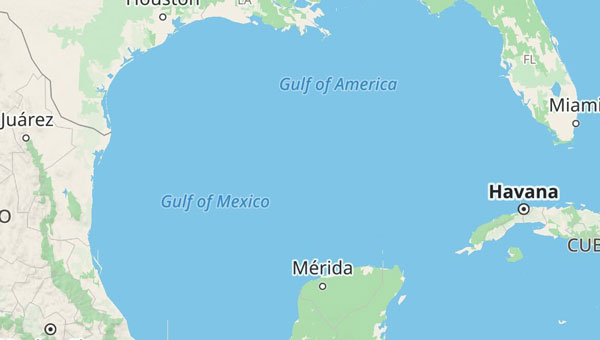
With the United States now recognizing the Gulf waters as the “Gulf of America” and not the “Gulf of Mexico,” digital map creators are deciding how best to reflect the name change for their users.
TomTom, for example, is introducing a U.S. geopolitical view for its users in the United States; they will see “Gulf of America.” Translations will be available in English, Spanish, French and German, and users searching for “Gulf of Mexico” will find the “Gulf of America.” Map users outside of the United States will see the default map view showing the “Gulf of Mexico.” Users searching for “Gulf of America” will find the existing “Gulf of Mexico” feature. All users will be able to change the view based on their preferences.
The company also expects to update its APIs, such as Search API, Geocoding API and Map Display APIs.
TomTom says its decisions are based on how the Geographic Names Information System and the International Hydrographic Organization view the name change.
TomTom and Esri have partnered to integrate TomTom’s global map and traffic data into ArcGIS, Esri’s comprehensive geospatial platform.
This collaboration aims to provide businesses and governments with location-based insights for various applications, including infrastructure maintenance, traffic flow analysis and retail site optimization. Esri is a prominent provider of geographic information system (GIS) technology, offering mapping and spatial analysis applications that facilitate efficient data collection, management and analysis. Organizations across various sectors — including governments, educational institutions, non-profits and businesses —can utilize the software.
In February 2023, Esri joined the Overture Maps Foundation, a collaborative effort initiated by Amazon Web Services, Meta, Microsoft and TomTom. This foundation aims to establish a location data standard and promote a data-sharing ecosystem to enhance maps, location technology applications and location-based insights.
The World Geospatial Industry Council (WGIC) at its annual general meeting announced the members of its board who will serve from May 2023 to April 2025. The board is comprised of 20 senior geospatial industry professionals drawn from WGIC’s patron, corporate and associate member companies. The board will provide strategic guidance to WGIC in pursuing its mission and achieving its programmatic goals during the next two years.
WGIC Executive Board Members
Theo Agelopoulos, Senior Director (Autodesk)
Zubran Solaiman, Director (Bentley Systems)
John Renard, President (Cyient)
Bushra Zaman, Director (Deep Spatial)
Elshan Musayev, EKM Global
Dean Angelides, Corporate Director — international (Esri)
Robert Hoddenbach, Global Director (Fugro)
Jean-Francois Gauthier, Vice President (GHGSat)
Adina Gillespie, Vice President (Hexagon)
Steven Sawdon, Director (IIC Technologies)
Paul Granito, Senior Vice President (Maxar Technologies)
Harsh Govind, Principal Product Manager (Microsoft)
Jayant Sharma, Senior Director (Oracle)
Agnieszka Lukaszczyk, Vice President (Planet)
James Van Rens, Senior Vice President (RIEGL International)
Willy Govender, CEO (Terra Analytics)
Marius Swanepoel, Director (TomTom)
Bryn Fosburgh, Senior Vice President (Trimble)
Joseph Seppi, Senior Vice President (Woolpert)
Sanjay Kumar, CEO (Honorary Member) (Geospatial World)
The bi-annual election for the office of WGIC president has witnessed a unanimous vote for Bryn Fosburgh, Senior Vice President, Trimble. Brian Nicholls, Vice President — Asia Pacific, Woolpert, was elected unopposed as the treasurer. To ensure business continuity, John Renard, President, Cyient — Europe, will continue as secretary general till April 2024.
TomTom and SWARCO have entered a strategic partnership to enable customers to improve their mobility-management operations by using floating car data-based traffic services to complement physical sensor hardware already installed in the field.
The high-quality traffic services from TomTom, generated from millions of anonymously collected GPS data from apps, cars and devices, are now integrated and available for public entities via SWARCO’s urban mobility management suite MyCity. This data source will enable SWARCO to offer a high-value enhancement to the traffic information it already provides to its customers.
Benefits to MyCity customers include:
real-time travel times for user-defined routes
historical reports on travel time to enable data-driven decision making and impact analysis
triggering strategies based on real-time floating car data to automatically adjust signal plans, reroute traffic or take other traffic management actions
filling potential blind spots between existing roadside sensors to get a complete picture of the traffic situation.
The strategic partnership between SWARCO and TomTom also includes a joint thought leadership program to educate the market further, regular alignments about new features and product updates, and intensified collaboration on funded research projects.
Experts from both companies are available to take city officials, traffic managers, consultants and partners on a test drive of the newly available solutions as well as offer free trials.
Verizon will integrate TomTom’s Maps application programming interfaces (API) and software development kits (SDK) into its location-services offering, making it easier for the developer community to build upon and integrate the platform. The developers’ portal is available at developer.tomtom.com. More information from
The agreement is an expansion of the existing TomTom and Verizon agreement, where TomTom provides location-based services to enhance Verizon’s current suite of location-based data, navigation, and intelligence.
“We look forward to continuing to build upon and evolve our product suite with TomTom’s technology,” said Jeff Frantz, executive director, Verizon Location Services. “By expanding our agreement, we are furthering our commitment to providing best-in-breed location technology for Verizon and our customers.”
“We’re determined to make it as easy as possible for developers to have access to our Maps APIs and SDKs so we’re delighted that Verizon is offering TomTom products to their location-services customers,” said Anders Truelsen, managing director, TomTom Enterprise.
5G and HD Maps. In the last quarter of 2019, the companies also announced an innovation project using Verizon 5G Ultra Wideband and TomTom HD Maps to help make intersections safer for emergency vehicles.
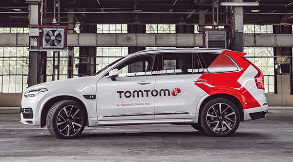
The TomTom autonomous test vehicle. (Photo: TomTom)
To grab a larger piece of the burgeoning connected and autonomous vehicle markets, digital mapmaker TomTom launched its self-driving test vehicle and is integrating navigation and diagnostic capabilities in the Microsoft Connected Vehicle Platform.
While the company has tested the technology for years, TomTom officially announced the availability of its own autonomous test vehicle, which Arnold Meijer, TomTom strategic manager, business development, said is a critical advantage to quickly develop maps and services for that industry.
“We can continuously test our mapping technology on the roads, get insights and high-quality data on how it performs in a multitude of circumstances and, right away, feed this into our AI-driven mapmaking process,” he said.
Currently, the vehicle is testing TomTom’s high-definition map; a crowd-sourced map update called Roadagrams; and a map-streaming service, AutoStream, which will deliver map data to vehicles on demand.
The company announced in September at the International Motor Show (IAA 2019) in Frankfurt, Germany, that its digital maps have doubled to more than 1 million Level 1 and Level 2 autonomous vehicles from several automakers.
Showcasing TomTom HD Maps
At IAA 2019, TomTom also demonstrated proof-of-concept high-definition map features that can work through Microsoft Azure cloud services, Meijer said. “Some of the navigation intelligence, which also includes traffic information and HD map services, can also be used in vehicles for navigation apps, as well as context while driving autonomously,” he said.
The demonstration allows TomTom to send telemetry data to Microsoft Azure. “[This includes] application usage data such as what menu items the end-user clicked on and what screens of the TomTom NavApp they opened for app analytics purposes,” he said.
Other features include GPS location during a driving simulation, vehicle speed and heading for driver behavior, and usage of apps that are not navigation-related, such as for music. Other testing included road speed limit, the number of times users drive a planned route, destination details planned by a user, and travel time.
TomTom navigation integrated into the Microsoft Connected Vehicle Platform allows automakers to quickly access precise navigation and driving behavior, “while of course adhering to TomTom’s privacy principles,” Meijer said. “This data could, for instance, be used to predict the range of an electric vehicle based on driving behavior and planned route more accurately. Or to work out, based on navigation behavior, what connectivity package for online navigation would be best suited for a driver.”
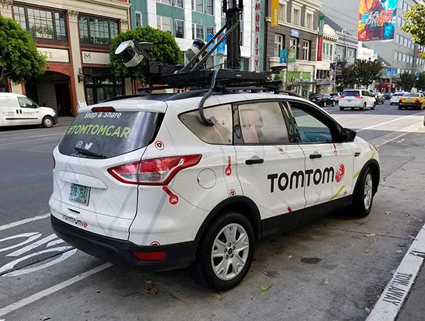
The TomTom Moma test vehicle prototype hits the road in San Francisco. (Photo: Kevin Dennehy)
Voyage Forges Ahead…
While recent press reports have said autonomous vehicle development is slowing because of technology limitations and consumer doubt, Palo Alto, Calif.-based Voyage has raised millions of dollars and continues to test self-driving cars in retirement communities in California and Florida.
The company recently raised $31 million in Series B funding from Franklin Templeton, Khosla Ventures, Jaguar Land-Rover’s InMotion Ventures and Chevron Technology Ventures. Voyage has raised a total of $52 million since its 2017 founding, said Oliver Cameron, company co-founder and CEO.
With the new funding, Cameron said the company hopes to triple its workforce, increase its second-generation fleet of self-driving cars, invest more in the technology and roll out a third-generation vehicle.
“We are taking a unique, focused approach to delivering truly driverless cars in communities where there are limited mobility options, customers who need an autonomous ride-hailing service, and lower speeds,” he said. “Many residents within our communities don’t have access to transportation options that work for them, so they’ve welcomed our fleet of self-driving vehicles. We’ve started with self-driving cars that can travel point-to-point within our communities at speeds of up to 25 mph.”
Cameron said the community-based approach allows the company to quickly design and deploy autonomous technology. “For the past two years, because we are taking this focused, community-based approach to designing and deploying advanced self-driving car technology, progress has been rapid. Our vehicles intelligently and autonomously navigate the complex neighborhoods of our communities and safely transport our passengers door-to-door,” he said.
The company said its engineers are transitioning software to a safety-critical middleware, shipping a new prediction engine with better capabilities and creating triple redundancy in the vehicle’s perception system.
G3 Vehicle? Not Yet. Voyage, which began testing self-driving with a retrofitted Ford Fusion, doesn’t have a timetable planned for a third-generation system, Cameron said. Instead, the company plans to continue to use the self-driving Chrysler Pacifica hybrid minivan in its testing projects.
“Before we launch our [third generation] self-driving car, we are going to build and scale more G2 self-driving cars to better serve the communities in which we operate. We haven’t announced a timeframe for the launch of our electric, truly driverless and highly scalable G3 self-driving car,” he said.
The company is growing its ranks as it has hired its first chief operations officer, Nina Qi. She believes the biggest hurdle autonomous vehicles have is the basic challenge to deliver safe and cost-effective services to make the industry economically sustainable.
The tools connect directly to TomTom Maps APIs (Application Programming Interfaces) for location, tracking and mapping data services, accelerating product development, and reducing time-to-market and development costs for developers, the companies said.
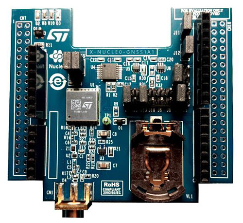
The X-NUCLEO-GNSS1A1 expansion board is based on the Teseo-LIV3F tiny GNSS module. (Photo: STMicroelectronics)
The development package consists of an STM32 Discovery host board for 2G/3G cellular-to-cloud connectivity, a GNSS expansion board based on ST’s Teseo satellite navigation technology, and a software Function Pack that connects an internet-of-things (IoT) node via a cellular network to a range of TomTom Maps APIs.
With this hardware and software package and a TomTom developer account, developers can quickly add location-based services to their IoT and smart city applications.
Among these services are the translation of GPS coordinates into a street address inside a map (Reverse Geocoding), retrieval of nearby point of interests, and the production of accurate navigation directions.
“We have combined TomTom’s industry-leading location-based and mapmaking technologies with ST’s unrivaled combination of silicon and system expertise to create a unique offering that provides easy access to TomTom’s Maps APIs to empower developers to create groundbreaking, location-aware applications faster and more efficiently,” said Anders Truelsen, managing director of TomTom’s Enterprise Business Unit.
“Supporting our efforts to facilitate location-based product development, our collaboration with TomTom has built on each company’s strengths to assemble a tailored package of hardware and software tools that is already fully integrated with TomTom cloud services, around the popular STM32 development ecosystem,” said Alessandro Cremonesi, group vice president at STMicroelectronics. “These tools enable native STM32-based location services to accelerate application development of Geo-IoT solutions for fleet management, item tracking, and many other services that depend on fast, accurate location detection.”
In addition to the STM32 family of Arm Cortex-M core microcontrollers, the development tools leverage ST’s market-proven multi-constellation Teseo positioning-receiver technology to perform all positioning operations including tracking, acquisition, navigation and data output.
TomTom and what3words will collaborate to bring what3words addressing to TomTom’s customers globally.
what3words addressing will roll out to TomTom consumer and automotive customers in the second half of 2018. TomTom made the announcement at TU Automotive Detroit.
what3words is a simple way to talk about location. The world is divided into a grid of 3 x 3-meter squares, and each square is assigned a unique three-word address. As such, what3words will complement TomTom’s existing maps, allowing people to accurately find any location and share it more quickly, easily and with less ambiguity than any other system.
The three-word address for TomTom’s head office, for example, can be found at ///pancake.climbing.beaker. The easy-to-use addressing system works well in areas where traditional maps and addressing don’t, including off-road locations and countries without standardized addressing systems such as India and the Middle East, the company said.
GPS World’s sister site, Geospatial Solutions, first discussed the innovation of what3words in 2015. It has since seen adoption by countries (such as Mongolia, Djibouti and Sint Maarten), and national mapping agencies of countries such as Norway and Switzerland. Sygic also adopted it for its fleet solutions.
“Whether you’re trying to find an address in the center of Turin, or on the streets of Tuvalu, TomTom wants to get you there quickly and efficiently,” said Antoine Saucier, managing director of TomTom Automotive. “Our collaboration with what3words demonstrates our commitment to embracing new addressing technology that is easy-to-use and integrates simply into our navigation offering.”
“We are delighted to partner with TomTom, and bring the benefits of more accurate addressing to their customers,” said Chris Sheldrick, CEO and co-founder of what3words. “By using what3words, drivers are able to navigate to any precise location — as specific as a side door, gate or parking spot. Equally, destinations that previously have been unaddressed now have a simple, reliable and easy-to-remember three-word address.”
TomTom has launched TomTom AutoStream, an innovative map delivery service for autonomous driving and advanced driver assistance systems. The first partners to use the technology — Baidu and Zenuity — were unveiled at the 2018 Consumer Electronics Show.
TomTom AutoStream enables vehicles to build a horizon for the road ahead by streaming the latest map data from the TomTom cloud. By ensuring that the map used to power advanced driving functions is always the latest, TomTom AutoStream enhances driver comfort and safety.
“The launch of TomTom AutoStream is a game-changer for OEMs and technology companies that are working on the future of driving,” said Willem Strijbosch, TomTom’s head of autonomous driving. “TomTom AutoStream allows vehicles to access the latest, most up-to-date TomTom map data for their driving automation functions.”
TomTom AutoStream is designed in a flexible way, allowing customers to customize the map data stream based on criteria such as sensor configuration and horizon length. It can stream a wide variety of map data including ADAS attributes such as gradient and curvature, and the TomTom HD Map with RoadDNA. This flexibility allows customers to use AutoStream to power a wide range of driving automation functions.
Strijbosch continued, “Our early investment in the TomTom advanced map-making platform means that we can continue to deliver revolutionary innovations like TomTom AutoStream. With TomTom AutoStream we can significantly simplify and shorten the development time for our customers, accelerating the future of driving.”
TomTom AutoStream ensures that the TomTom map data used to power advanced driving functions is the latest, most accurate available, enabling a safer and more comfortable experience.
“With AutoStream TomTom is offering an innovative map delivery system targeted at automated driving,” said Roger C. Lanctot, director, Automotive Connected Mobility for Strategy Analytics. “The development is targeted at helping automakers bring ADAS and autonomous driving functions to market faster.”
TomTom AutoStream will be available for production usage in 2018.
Members of the public often turn to GPS World and Geospatial Solutions for help when their personal device gives them incorrect mapping information.
GPS.gov has set up a page that points users to the correct place to report problems, by walking them through a series of steps.
As our readers know, the problem isn’t with the satellites, but in the mapping software used by the devices and apps. Links are provided to mapping companies Google, Waze, TomTom, HERE, OpenStreetMap, Garmin and Apple.
Qualcomm Technologies Inc., a subsidiary of Qualcomm Incorporated, is working with TomTom on using the Qualcomm Drive Data Platform for high-definition (HD) map crowdsourcing for autonomous driving.
Qualcomm Drive Data Platform collects and analyzes data from different vehicle sensors, supporting smarter vehicles to determine their location, monitor and learn driving patterns, perceive their surroundings, and share this perception with the rest of the world reliably and accurately.
TomTom’s HD Map, including RoadDNA, is a highly accurate, digital map-based product that assists automated vehicles to precisely locate themselves on the road and help determine which way to maneuver, even when traveling at high speeds.
Traditional development of maps requires deploying dedicated fleets of vehicles equipped with professional-grade sensors to collect location, raw imagery, lidar and other data, which is then transferred, stored and processed in data centers. Now that cars are increasingly connected and equipped with a range of sensors, new and complimentary approaches become possible.
Using the precise positioning, on-device machine learning, heterogeneous compute and connectivity capabilities of the Qualcomm Drive Data Platform, which features the Qualcomm Snapdragon 820Am automotive processor, TomTom and Qualcomm Technologies aim to facilitate adding an improved, scalable and cost-efficient crowdsourcing approach to the mix of sources for HD mapmaking.
The new concept is designed to allow massive numbers of connected cars to see and understand their environment, traffic and road conditions, and support real-time input for map and road condition updates.
“Feature-rich, highly accurate and frequently updated HD maps are critical to support some of the most advanced applications envisioned in the automotive industry, especially for autonomous driving,” said Willem Strijbosch, head of autonomous driving, TomTom. “We are building the cloud-based platform to make and maintain HD maps using a range of input sources, including crowdsourced data from swarms of intelligent connected vehicles. We’re excited to explore the connectivity and compute capabilities of the Qualcomm Drive Data Platform to help map the world for the future of driving.”
“Qualcomm Technologies is demonstrating today that an affordable and easy-to-integrate mapping solution for autonomous vehicles is realizable,” said Nakul Duggal, vice president, product management, Qualcomm Technologies, Inc. “The Qualcomm Drive Data Platform is designed to integrate key technologies into a cost-effective edge compute solution required to support safer, highly connected and smarter transportation, and we are pleased to offer this technology for HD Map providers such as TomTom as well as automakers, shared mobility service providers and automotive industry at large.”
For more information about the Qualcomm Drive Data Platform, visit the Qualcomm booth at Mobile World Congress in Barcelona, Feb. 27–March 2, Hall 3, Stand 3E10, or go to www.qualcomm.com/automotive.