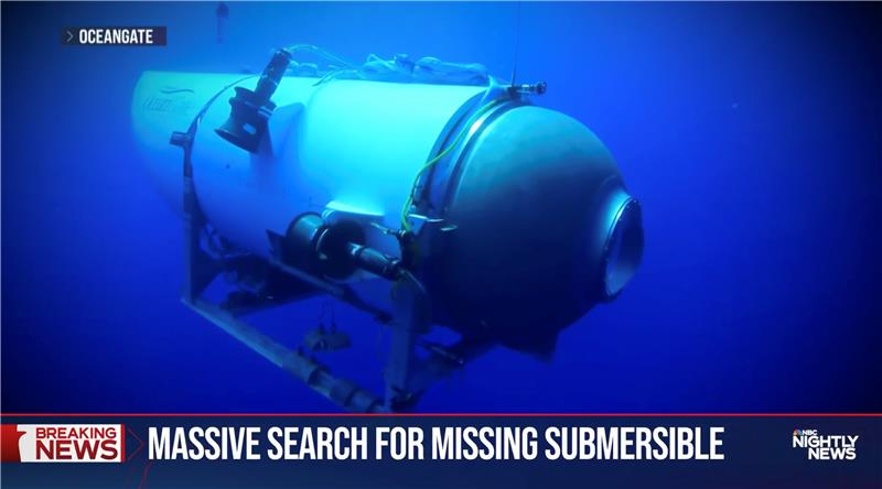
OceanGate. (Credit: Screenshot of NBC news coverage)
On June 17, an OceanGate Expedition Titan submersible launched off the coast of Newfoundland, Canada, carrying five passengers to the bottom of the Atlantic Ocean to explore the infamous R.M.S. Titanic shipwreck. The U.S. Coast Guard said that the submersible lost contact with the surface vessel about an hour and 45 minutes after the launch and has not been in contact since.
The submersible can support life for 96 hours. As of the afternoon of June 20, it had 40 hours of oxygen left and U.S. and Canadian agencies were still searching for it.
The Titan submersible explained
According to the OceanGate website, the Titan is “a Cyclops-class manned submersible designed to take five people to depths of 4,000 [m] (13,123 [ft]) for site survey and inspection, research and data collection, film and media production, and deep-sea testing of hardware and software.” The Titan is equipped with an inertial navigation system (INS), an ultra-short base line acoustic positioning system, a robotics laser scanner, a Teledyne 2D sonar and more.
While it is equipped with an INS, the Titan relies on messages from a surface ship to guide the submersible to the shipwreck. The submersible and surface vessel rely on Elon Musk’s Starlink satellites for communication.
A part of the Titan worth mentioning, the crew is sealed inside and bolts are applied to the outside — needing an external crew to remove them upon surfacing.
Foreshadowing
The New York Postreported, in 2022, that an OceanGate Expedition to the Titanic lost contact for more than two hours and never found the wreck.
Aboard the submersible was a CBS correspondent, David Pogue, who was filming a segment for CBS Sunday Morning. He tweeted about the incident.
There are 18 planned expeditions to the Titanic with OcenGate Expeditions to survey the shipwreck, collect data, and document high-resolution images and videos.
The entire trip to the Titanic wreck site takes 8 days, and one dive can take up to 10 hours. The expedition is comprised of five legs.
The C-130 Hercules aircraft is used to rapidly drop cargo to provide relief after disasters or troops into battle zones. (Image: USAF Devin Doskey- 341st Missile Wing Public Affairs)
GPS Innovation Alliance (GPSIA) member companies are leaders in technology, transforming the digital and physical world around us. With countless essential applications, GPSIA members improve the industries that feed, build, move and connect communities across the globe. In times of need, the GPS industry is proud to rise to the occasion, whether through agriculture technologies, surveying equipment, navigation systems, essential communications tools, or humanitarian relief efforts. Simply put, GPSIA members are continually investing in lifesaving services at home and abroad.
Take, for example, the urgent need for humanitarian relief created by the ongoing war in Ukraine. Trimble has stood united to support the many affected and displaced Ukrainians; in addition to contributing through the Trimble Foundation to relief efforts in Ukraine and neighboring countries, Trimble also has provided GPS signal corrections to Ukrainian farmers at no cost, supplied 3D scanners for surveying damaged buildings, and worked closely with The HALO Trust to support demining activities in Ukraine by providing funding and commercial surveying systems to assist in precision mapping of landmines and unexploded ordnances.
Lockheed Martin’s C-130 Hercules aircraft has assisted essential humanitarian relief across the globe. Since its inaugural flight in 1954, this aircraft has enabled aid delivery, natural disaster relief, medevac services, search and rescue and more. Now equipped with GPS technology, the C-130 fleet has provided aid across the globe for decades — with L3Harris’ missionization solutions often at work to maximize the C-130’s utility. Similarly, Collins Aerospace’s state-of-the-art navigational technology has provided essential support to U.S. Coast Guard helicopters, with avionics upgrades that help pilots save time in emergencies and enhance situational awareness.
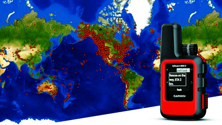
Garmin inReach devices can send and receive messages, navigate routes, track and share journeys and can trigger an SOS if needed. (Image: Garmin)
More broadly, Garmin inReach satellite communication devices have helped more than 10,000 individuals access emergency services, providing critical communications in natural disasters and humanitarian emergencies. In 2022, a powerful underwater volcanic eruption and tsunami devastated the island nation of Tonga, severing traditional communications channels for several weeks. Roy Neyman, a sailor equipped with this Garmin device, set up a communication center at a local restaurant to allow other residents to reach family and friends. Over two weeks, Tonga residents sent about 1,600 messages to loved ones around the world, offering peace of mind in the face of unthinkable destruction. Similarly, Apple recently launched an “Emergency SOS” service, which led to one of the first successful rescue efforts of two people who had driven off a highway in the Angeles National Forest.
CalAmp’s Fusion routers enable lifesaving emergency services to more than 400,000 residents in Oakland, California. Equipped with GPS, LTE and WiFi technology, these routers help Oakland Fire first responders quickly locate emergencies and access additional resources, such as building layouts or fire records, to provide the best possible emergency response. CalAmp’s technology provides an essential service to residents of Oakland and can be adapted to meet the changing needs of the community.
As the world of agriculture has come to depend on GPS technology, John Deere’s GPS-based agricultural services have helped farmers become more efficient. In turn, this has allowed farmers to harvest more crops for the masses and meet the ever-growing demand for food. With the annual growth in food demand estimated to be 1.4% over the next decade, John Deere’s critical investment in food banks in Mexico and training for farmers in Africa will help to ensure that all communities are able to access the food they need.
Across industries and government, GPS technology makes for a safer, more connected world. GPSIA is proud of its members’ dedication to global humanitarian efforts as well as critical services close to home. By constantly innovating, GPSIA member companies are creating technologies that provide critical services for everyday emergencies, natural disasters, and humanitarian crises across the globe.
The NAVCEN website upgrade and redesign is now live.
“This is an exciting moment for our team,” said Stephanie Southwick, NAVCEN web team. “Thank you again for your patience as we move forth with this transition to improve user experience and to provide the public with timely and reliable maritime safety information.”
As a reminder, while the primary URL will stay the same, all sub-URLs have changed with the transition. Use of any bookmarked legacy URLs will result in broken links, including PDFs and URLs used in automatic downloading of data and products. “We appreciate your patience in re-bookmarking your favorite pages when we update the site,” Southwick said.
The NAVCEN outreach team will work with users to ensure transition to using the redesigned site is as seamless as possible. Communicate with the team at[email protected] with questions or to request additional information.
For more information on the changes, visit this page.
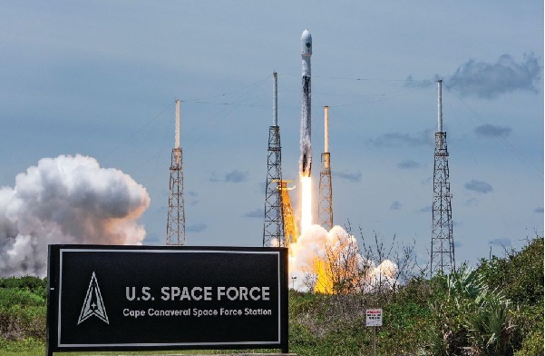
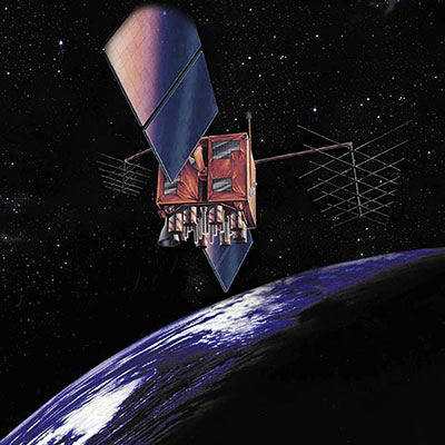
The fifth GPS III satellite is now set healthy for initial operational use, according to the U.S. Coast Guard Navigation Center (NAVCEN). GPS III 05 (SVN-78/PRN-11) was launched June 17, 2021, from Space Launch Complex-40 at Cape Canaveral Air Force Station, Florida.
Constellation Changes
The U.S. Space Force Second Space Operations Squadron (2 SOPS) indicates that GPSIII 05 replaced SVN-61/PRN-28 in the D plane at slot D1.
SVN-61 is being rephased to optimize its position in the D plane, and is expected to complete its journey on or about July 14.
SVN-44/PRN-28 was moved to GLAN 31.64 to optimize its position within B plane.
GPS III space vehicle 05 (GPS III-SV05) launched in June 2021 from Cape Canaveral Space Force Base, Florida, aboard a SpaceX Falcon 9 launch vehicle. (Photo: SpaceX)
The U.S. Coast Guard Navigation Center (NAVCEN) will transition to a new and enhanced website in the first quarter of this year. The actual transition date has yet to be determined.
As part of the transition, the URLs will be updated across the site, including URLs linked to PDFs. URLs from the legacy site will no longer work. Any bookmarked URLs or URLs used in automatic downloading of data or products will need to be updated.
“We have identified the below URLs as essential to your continued business,” reports Rick Hamilton, CGSIC Executive Secretariat, in a . “Please keep in mind, that while we are sending the URLs in advance, they will not be active until we launch the new website. Once the new website goes live, your URLs will be available for re-bookmarking.”
Artist’s rendition of a GPS-IIR satellite in orbit. (Image: GPS.gov)
The U.S. Space Force has announced the decommissioning of GPS satellite SVN-47 (PRN-22), which officially took place Jan. 18. The satellite has been unusable since Dec. 2.
SVN-47 was a replacement satellite in the second generation of GPS satellites (GPS-IIR), launched Dec. 21, 2003.
The announcement was made in a Notice Advisory to NavStar Users (NANU 2022001) issued by NAVCEN, U.S. Coast Guard.
The designation PRN-22 will be used to bring SVN-41 back in to the active constellation. After 2200 Zulu on Jan. 2o, GPS will transition SVN-41 (PRN-22) into the broadcast almanac for all satellites, and SVN-41 will resume transmitting L-band signals. The almanac transition, accomplished one satellite at a time, will require approximately 24 hours to complete.
A second NANU emphasized that “Before, during, and after transition SVN-41 (PRN22) will remain unusable until further notice.”
SVN-41, the sixth of the GPS-IIR satellites, was launched on Nov. 10, 2000, and set to active service a month later on Dec. 10. It was decommissioned in July 2021.
The U.S. Coast Guard has issued a statement on a possible GPS software bug that could send systems back to 2002.
The potential vulnerability may cause an event of the “GPS Week Number Rollover” type to occur within systems utilizing Network Timing Protocol Daemon (NTPD) and GPS Daemon (GPSD) software.
On Oct. 24, a bug in older versions of the software may trigger the system date to roll back to sometime in March 2002. All systems running the most recent software update, version 3.23.1 (released Sept. 21) should be unaffected.
While this is not a problem with GPS, this has the potential to cause significant impact, the Coast Guard stated. All networks operating are encouraged to verify that they are using the most recent version (3.23.1) and report any problems to the Navigation Center watch by phone 703-313-5900 or by email at [email protected].
In a slight expansion from our previous monthly UAV newsletter columns, we’re now looking at autonomous systems with a wider outlook, capturing the automated world as it evolves.
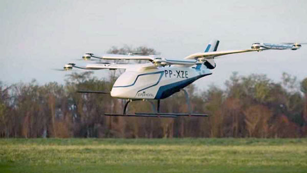
The Eve air taxi. (Image: EmbraerX)
News this month covers steps toward air taxi qualification, highly challenging underground UAV and robotic capers, and long-distance watercraft autonomy in Denmark.
EVE gets order boost by Bristow
We’ll soon be seeing them — electric powered manned and unmanned flying taxis buzzing in the city skies above us. Embraer, the Brazilian commuter aircraft manufacturer (you might have taken their EMB-1xx series turboprop aircraft on short hauls between city centers) has apparently progressed its Eve manned/unmanned aircraft development to the stage of a program for qualification/certification being scoped by EmbraerX in Florida and the Bristow Group.
Parent company Embraer established EmbraerX in Melbourne, Florida, as a new-concept UAV developer and manufacturer, launching the Eve urban mobility vehicle as its first product.
Eve subscale demonstrator. (Photo: EmbraerX)
Although we are still only seeing concept-artist renderings of the Eve eVTOL (electric vertical take-off and landing) aircraft, and photographs of a small-scale flying prototype, Embraer has already built an impressive order book. There are reports of more than 500 orders on hand, originally led by Uber and recently joined by the Bristow Group with an order for 100. All orders are likely contingent on aviation agency approval of the aircraft for public transportation.
Based worldwide, Bristow has been around in one form or another since 1955, and currently operates more than 250 helicopters in support of the oil and gas industry, search and rescue (SAR), and various military-related applications, including unmanned aircraft operations with the U.S. Coast Guard. This experience is expected to aid EmbraerX through a joint program to eventually gain an operating certificate for the Eve air taxi.
An Elios drone from team CERBERUS roams a moulin in an earlier challenge. (Photo: DARPA)
DARPA’s Subterranean Challenge
The U.S. Army’s Defense Advanced Research Projects Agency (DARPA) has been running a competition since 2018 to find unmanned products and technologies that can find their way around underground environments such as subway systems, sewers, mines and naturally occurring caves and tunnels. The object is to rapidly and remotely map, navigate and search these complex underground locations.
Known as DARPA’s Subterranean Challenge, several groups of competitors were slimmed down to three very capable teams over several months through some initial selection evaluations. Then, on final competition day, teams CSIRO Data61, CERBERUS and MARBLE went at it in an array of challenging environments at the Louisville Mega Cavern — a massive retired limestone mine so large it not only hosts a ropes course and a mountain bike park, but also has tram-guided tours for visitors.
Finalists in the competition had to navigate through elements from previous events, including simulated underground mines, a metropolitan infrastructure, and cave systems. Smoke was even used in places to increase the confusion.
Team CERBERUS — an international consortium that included the University of Nevada Reno (UNR), ETH Zurich, the Norwegian University of Science and Technology (NTNU), the University of California Berkeley, the University of Oxford, Flyability, and the Sierra Nevada Corporation — was ultimately successful.
The ANYmal climbs stairs. (Photo: ANYbotics)
In previous phases of the competition, Flyability used its caged Elios 2 UAV with video and thermal cameras and a high-intensity LED lighting system to create accurate internal maps of underground spaces. However, in the final competition, ANYbotics four-legged ANYmal C autonomous robots were primarily employed — carrying visual and thermal cameras, lidar and a spotlight.
In the final competition, Team CERBERUS managed to locate and identify 23 of 40 hidden “artifacts” in the allocated time and earned the $2 million DARPA first-place prize.
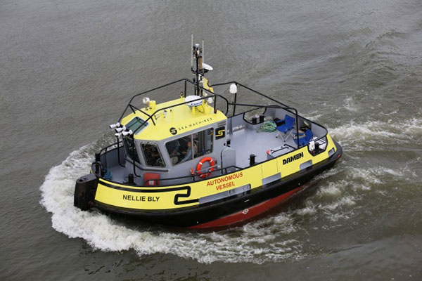
Autonomous Tugboat round Denmark
Sea Machines in Boston has been around since 2015, focusing on automating shipping control and monitoring. It hopes to bring a system to market that will enable an autonomous voyage all the way around Denmark.
With investors who include Toyota Ventures, Huntington Ingalls, Brunswick Corporation, Accomplice and Dolby Fund, the company is not a mega-million venture, but has still successfully engaged the likes of A.P. Moller-Maersk, the U.S. Department of Transportation and the U.S. Navy in autonomous waterborne projects.
The tugboat Nellie Bly on its 1,000 nm circumnavigation of Denmark will use an SM300 autonomous system that uses radar, inertial navigation, a depth transducer, the automatic identification system (AIS) and video cameras for obstacle avoidance. It will provide high-definition remote situation awareness to monitoring controllers in Boston, 3,600 miles away.
Autonomous tugboat Nellie Bly. (Photo: Arie Boer)
Throughout the voyage, the Nellie Bly will have two professional pilots onboard, and will stop at ports along the way to demonstrate the technology. Sea Machines will stream the journey live on a website with updates from the ship, the crew and the command center, enabling real-time and recorded access to “The Machine Odyssey” as the project is now known.
To sum up, lots of autonomous projects are proceeding, with progress toward getting air taxis up and running for business, DARPA sponsoring technology for underground navigating, and mapping and long-distance autonomous navigation around Denmark — lots of diversity and opportunity.
The U.S. Department of Transportation (DOT) and the U.S. Coast Guard Navigation Center (NAVCEN) will hold the 61st meeting of the Civil GPS Service Interface Committee (CGSIC) on Sept. 20-21.
The meeting will be conducted at the St. Louis Union Station Hotel in St. Louis, Missouri, in conjunction with the Institute of Navigation’s 2021 ION GNSS+ conference.
The 61st CGSIC meeting will also be broadcast live online to provide a virtual option. This is a unique opportunity for anyone in the world with access to a computer to attend these public meetings of the U.S. Civil GPS program. CGSIC meetings are free and open to the public.
The three subcommittees of the CGSIC will meet on Sept. 20: Timing; International Information; and Surveying, Mapping, and Geosciences.
Summaries of the subcommittee meetings will be presented to the CGSIC plenary session Sept. 21 with a keynote address by Juliana Blackwell, director of NOAA’s National Geodetic Survey (NGS).
The U.S. Space Force Space and Missile Systems Center (SMC) has issued official, signed Interface Specification (IS) and Interface Control Document (ICD) revisions for GPS. The documents listed are available through the U.S. Coast Guard’s GPS Technical References and at GPS.gov.
IS-GPS-200M Navstar GPS Space Segment/Navigation User Interfaces
IS-GPS-800H Navstar GPS Space Segment/User Segment L1C Interface
IS-GPS-705H Navstar GPS Space Segment/User Segment L5 Interface
ICD-GPS-240D Navstar GPS Control Segment to User Support Community Interface
Past versions of these documents are archived at GPS Technical References and at GPS.gov Old Versions. Interface Revision Notices (IRN) incorporated into the new documents also can be found on these websites.
The Space Force is soliciting public comments on the following Proposed Change Notices (PCNs).
RFC-00467: 2021 Proposed Changes to the Public Documents
While these PCNs use the August 2020 versions of the ICDs as baseline documents, any approved changes will be incorporated by the next document revisions. Comments are due Aug.24.
SMC has also announced the date of the next Public Interface Control Working Group meeting. Full details will be provided in an upcoming Federal Register Notice, but advance notice can be found here.
PNT services, such as GPS, are a national critical function that enable many applications within the critical infrastructure sectors. However, “The increasing reliance on GPS for military, civil and commercial applications makes the system vulnerable,” according to Space Policy Directive-7 (SPD-7), issued Jan. 15. “GPS users must plan for potential signal loss and take reasonable steps to verify or authenticate the integrity of the received GPS data and ranging signal, especially in applications where even small degradations can result in loss of life.”
The PNT Integrity Library and Epsilon Algorithm Suite address this issue by providing users a method to verify the integrity of the received GPS data. “We are excited to release these resources to the PNT community to improve resiliency against potential GPS signal loss,” said DHS S&T PNT Program Manager Brannan Villee.
“Since GPS signals can be jammed or spoofed, critical infrastructure systems should not be designed with the assumption that GPS data will always be available or will always be accurate,” said Jim Platt, chief of Strategic Defense Initiatives at the Cybersecurity and Information Security Agency (CISA) National Risk Management Center. “Application of these tools will provide increased security against GPS disruptions. However, DHS also recommends a holistic defense strategy that considers the integrity of the PNT data from its reception through its use in the supported system.”
The PNT Integrity Library and Epsilon Algorithm Suite are open source and available free of charge. To view more details, visit the DHS S&T PNT Program.
Lockheed Martin Space has released the GPS-III satellite antenna phase-center data, as well as the group delay and inter-signal correction data, for SVN-76 and SVN-77 as measured at the factory, announced the U.S. Coast Guard’s Civil GPS Service Interface Committee (CGSIC).
The phase center and inter-signal bias data included in this new release provide additional information that supplements the antenna gain pattern data previously available.
Note that the GPS III satellite vehicles (SVNs) also broadcast the Inter-Signal Corrections (ISCs) in the various LNAV/CNAV messages in accordance with all the external IS/ICDs. The value that is being broadcast by the on-orbit constellation is not the factory measured ISCs but the ISCs estimated on-orbit by the Stanford Research Institute (SRI).