Author: Allison Kral

  • Septentrio, Point One Navigation to partner for autonomous vehicle demo

    Septentrio has teamed up with Point One Navigation, a provider of precise location as a service, for autonomous vehicle demonstrations during the 2019 International Consumer Electronics Show, which will take place Jan. 8-11 in Las Vegas. During the conference, invitees will be able to ride in a fully autonomous demonstration vehicle that incorporates technology from both companies, as well as meet directly with technical experts, reports GIM International.

    During the demonstration, Point One Navigation will showcase its proof-of-concept autonomous vehicle equipped with the the FusionEngine vehicle localization software. According to the company, demonstrations will utilize corrections from Point One’s Polaris Cloud, a new correction network that enables high-precision GPS and computer vision-based localization, while allowing the customer to choose the performance and price point that best fits their application.

    According to GIM International, Point One’s solution is powered by Septentrio’s GNSS receivers. For accurate positioning of autonomous vehicles, Septentrio utilizes at least two frequencies broadcast by each GNSS constellation (BeiDou, Galileo, GLONASS, GPS, QZSS), the companies said.

    For users operating in open sky scenarios, a Septentrio RTK receiver can be used directly with Polaris Cloud to provide centimeter-level accuracy.

    Point One Navigation has chosen to work with Septentrio to power its solutions for both the correction network and our FusionEngine reference design because of the excellent quality, robustness and jamming resistance of their GNSS receiver technology, said Aaron Nathan, CEO and co-founder of Point One Navigation.

  • CHC Navigation releases all-in-one GNSS RTK solution

    CHC Navigation releases all-in-one GNSS RTK solution

    The i50 GNSS receiver comes bundled with the CHC HCE320 Android controller and CHC LandStar 7 field data collection software. (Photo: CHC Navigation)
    The i50 GNSS receiver comes bundled with the CHC HCE320 Android controller and CHC LandStar 7 field data collection software. (Photo: CHC Navigation)

    CHC Navigation has unveiled its i50 GNSS receiver, an all-in-one GNSS RTK solution.

    The GNSS receiver comes bundled with the CHC HCE320 Android controller and CHC LandStar 7 field data collection software. According to the company, it is a cost-effective solution for topographic and construction positioning tasks in land surveying, small- and medium-sized construction projects, and precision GIS data collection.

    “The i50 GNSS is designed to match the demand of cost-conscious yet demanding professionals searching for one all-in-one GNSS RTK survey solution,” said Hans Huang, product manager of GNSS solutions for CHC Navigation. “By integrating field proven GNSS positioning and communication technologies in a compact and rugged unit, land surveyors will experience unmatched work flexibility in their daily field work with CHC i50.”

  • United Technologies Corp. acquires Rockwell Collins

    United Technologies Corp. acquires Rockwell Collins

    Logo: Collins AerospaceUnited Technologies Corp. (UTC) has completed its acquisition of Rockwell Collins. The two companies will now combine to form Collins Aerospace Systems and be based in Palm Beach City, Florida.

    Collins Aerospace Systems will have about 70,000 employees. Rockwell Collins CEO and President Kelly Ortberg will be the CEO of the newly formed company. UTC Aerospace President Dave Gitlin will serve as president.

    There are no immediate changes planned as to how many employees will be based in Cedar Rapids, Iowa, or Collins Aerospace’s other locations in Eastern Iowa, said Collins Aerospace spokeswoman Pam Tvrdy-Cleary.

    However, the company’s avionics and mission systems will be based in Cedar Rapids. Kent Statler, former Rockwell chief operating officer for commercial systems, will head the avionics unit, and Phil Jasper, former Rockwell chief operating officer for government systems, will be in charge of the mission systems.

  • Blue Marble releases 2019 Geographic Calculator

    Logo: Geographic Calculator 2019Blue Marble Geographics has launched its 2019 Geographic Calculator, which features a universal copy and paste function, a new angular unit conversion tool, support for NADCON 5.0 and updated seismic survey conversion functionality.

    According to Blue Marble, the foundation of the Geographic Calculator’s geodetic data processing functionality is the embedded GeoCalc datasource, which is continually revised and improved with updates through the online GeoCalc Geodetic Registry. The datasource included in the 2019 release mirrors the most current EPSG database definitions.

    The calculator’s copy and paste function can be used to quickly capture data for use in a third-party application or to insert new coordinate values in an existing job. The latest version also includes a new tool for accurately converting between various angular units and offers expanded seismic survey conversion capability with improved P1/11 format support and additional SEG-Y format handling for coordinate scalar values, the company added.

    The 2019 Geographic Calculator also includes support for NADCON 5.0 from the National Geodetic Survey, providing 3D coordinate transformations within the National Spatial Reference System, as well as several new projection methods.

    The calculator also boasts a refreshed interface with new icons and graphic elements for various jobs and tools, as well as optimized architecture for the Windows 10 environment.

    “With the imminent approach of the North American Terrestrial Reference Frame in 2022 the need for highly accurate geodetic tools has become more important than ever,” said Patrick Cunningham, president at Blue Marble. “Geographic Calculator continues to lead the way in this field and as is evident in release of the 2019 edition, we are continually raising the bar by providing ever more powerful tools combined with the world’s most expansive geodetic database.”

    Blue Marble Geographics is a mapping software company based in Hallowell, Maine. The company offers a number of GIS software solutions, including data conversion, software development kits, low cost GIS, educational resources, 3D analysis, coordinate transformation and GPS.

  • A look at NGS’ experimental and hybrid geoid models

    A look at NGS’ experimental and hybrid geoid models

    On Aug. 10, the National Geodetic Survey (NGS) released its latest experimental geoid model, xGeoid18. In early 2019, NGS is scheduled to release its next hybrid geoid model, Geoid18.

    NGS’ 2018 experimental geoid model, xGeoid18, and the next hybrid geoid model, Geoid18, are not the same. This column will address the latest experimental geoid model, xGeoid18, and the future hybrid geoid model, Geoid18, and why it’s important to understand that they are very different and cannot be interchanged.

    In my October 2015 column, I described the differences between NGS’ hybrid geoid models and their experimental geoid models. It has been three years since I wrote the newsletter that addressed the differences between the experimental geoid model and hybrid geoid models. NAPGD2022 is now only about three years away. There will be significant differences between NAVD 88 and NAPGD2022 height.

    My June 2017 column provided an estimate of the differences based on the 2016 experimental geoid model, xGeoid16b. These differences between NAVD 88 and NAPGD2022 will vary from state to state, as well as within an individual State. Products referenced to NAVD 88 will be different from products referenced to NAPGD2022. Users will need to prepare for the NAPGD2022 and develop implementation plans. Users should obtain an understanding of the differences between NAPGD2022 and NAVD 88.

    NGS has a webpage that provides information on all of their experimental geoid models. It page provides information on the development of the program and information on each of the experimental geoid models.

    NGS’ Experimental Geoid Website

    Photo: National Geodetic Survey 
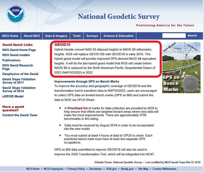
Photo: National Geodetic Survey. Click to enlarge.

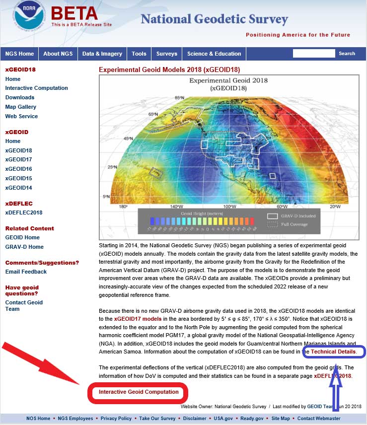
    If the user clicks on the xGeoid18 button (see orange arrow in the box titled “NGS’ Experimental Geoid Web Site”), the experimental geoid model xGeoid18 web page appears (see box titled “NGS’ Experimental Geoid Models 2018 Web Site”).

    NGS’ Experimental Geoid Models 2018 Website

    Photo: National Geodetic Survey

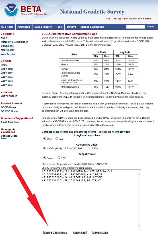
    Once users get to the xGeoid18 web site, they can obtain estimates of xGeoid18 values for any latitude and longitude by clicking on the button titled “Interactive Geoid Computation.” See red arrow in box titled “NGS’ Experimental Geoid Models 2018 Web Site.”

    Input Page of xGeoid18 Interactive Web Page Using the Sample Dataset

    Photo: National Geodetic Survey

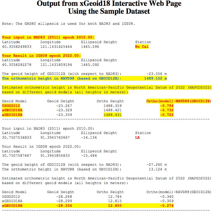
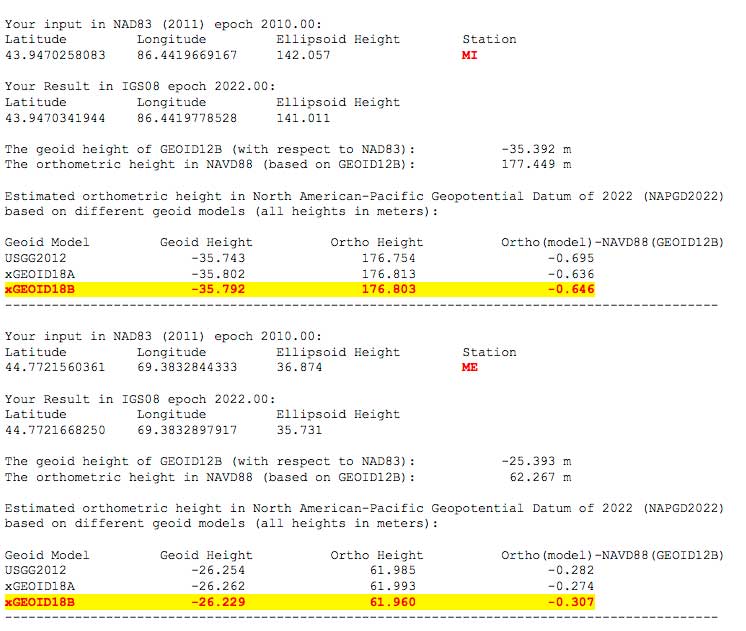
    Users should note that the output of the xGeoid18 interactive web service provides the results in IGS08 epoch 2022.00. The output provides an estimate of the NAVD 88 orthometric height based on GEOID12B, an estimate of the NAPGD2022 orthometric height based on xGeoid18b, and the difference between NAPGD2022 and NAVD 88. The box titled “Output from xGeoid18 Interactive Web Page Using the Sample Dataset” shows the output from the interactive web service using the sample dataset provided by the web service.

    The sample dataset has four stations — a station in California, Louisiana, Michigan and Maine. The results indicate that the differences will vary from state to state — the difference between NAPGD2022 and NAVD 88 in California using xGeoid18b is -0.722 meters, in Louisiana the difference is -0.274 meters, in Michigan the difference is -0.646 meters, and in Maine the difference is -0.307 meters (see box titled “Output from xGeoid18 Interactive Website Using the Sample Dataset”). More detailed estimates of differences between NAPGD2022 and NAVD 88 based on xGeoid16b can be found in my June 2017 column.

    Output from xGeoid18 Interactive Website Using the Sample Dataset

    Note: The GRS80 ellipsoid is used for both NAD83 and IGS08.

    Data: National Geodetic Survey

    Data: National Geodetic Survey

    Users can find technical information on xGeoid18 by clicking on the link labeled as Technical Details on the xGeoid18 website (see blue arrow in box titled “NGS’ Experimental Geoid Models 2018 Web Site”). The box titled “Excerpt from Technical Details for xGEOID18 Models” provides an excerpt of the technical details of xGeoid18.

    Excerpt from Technical Details for xGEOID18 Models

    Summary
    xGEOID18 is identical to xGEOID17 in the area bordered by 5˚ ≤ φ ≤ 85˚, 170˚ ≤ λ ≤ 350˚, which includes CONUS, Alaska, Hawaii, and Puerto Rico. Therefore, for information on xGEOID18 in those areas, the user should refer to the Technical Details of xGEOID17.

    For extended areas down to the equator and above latitude 85˚ north, the geoid is computed from the NGA’s Preliminary Geopotential Model 2017 (PGM17).

    The geoid models for Guam/central Northern Marianas Islands and American Samoa are computed in the closest way as xGEOID17 using the shipborne gravity, altimetric gravity and the reference gravity model PGM17.

    The deflections of the vertical are computed from all the geoid grids and the plumb curvature correction is applied by using the classical Bouguer reduction.


    As the technical detail webpage states, xGEOID18 is identical to xGEOID17 in the area bordered by 5˚ ≤ φ ≤ 85˚, 170˚ ≤ λ ≤ 350˚, which includes CONUS, Alaska, Hawaii and Puerto Rico. Therefore, for information on xGEOID18 in those areas, the user should refer to the Technical Details of xGEOID17. The box titled “Excerpt from Technical Details for xGEOID17 Models” provides an excerpt of the technical details of xGeoid17. This link provides figures that show the contribution of the airborne gravity data to the geoid models. See boxes titled “Excerpt from Technical Details for xGEOID17 Models” and “Figure (2,3,4,5) from Technical Details for xGEOID17 Models.” As stated in the technical details, users can examine each of the regional plots to see where the incorporation of GRAV-D data has changed the values of the xGeoid17B model.

    Excerpt from Technical Details for xGEOID17 Models

    GRAV-D Airborne Gravity Contribution

    The xGEOID17A and xGEOID17B models are identical except that xGEOID17B includes the available GRAV-D airborne gravity data. The difference between the two models shows the contribution of the airborne gravity data to the geoid models. Since the differences are only in areas where the GRAV-D airborne gravity data has been used, examining the regional plots given below will illustrate the varying levels of improvement due to GRAV-D, seen in different parts of the country.

    Photo: National Geodetic Survey

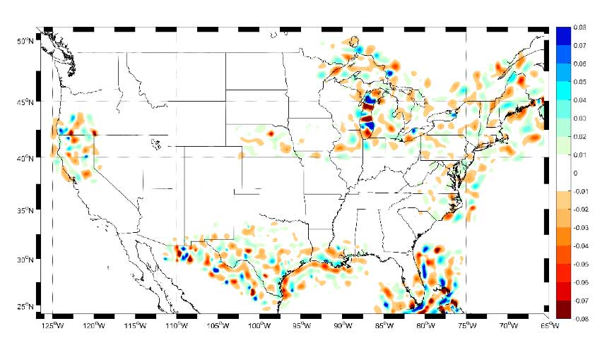
    Figure 1. CONUS – Contribution of GRAV-D airborne gravity [units in cm]

    Figure 2 from Technical Details for xGEOID17 Models

    Photo: National Geodetic Survey

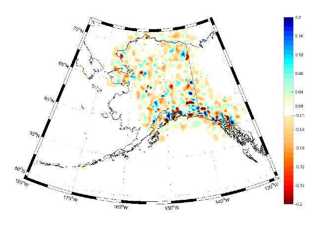
    Figure 2. Alaska – Contribution of GRAV-D airborne gravity [units in cm]

    Figure 3 from Technical Details for xGEOID17 Models

    Photo: National Geodetic Survey

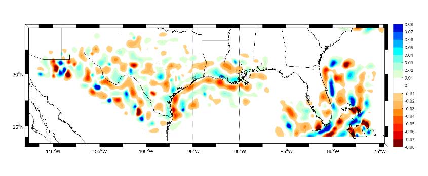
    Figure 3. Gulf Coast – Contribution of GRAV-D airborne gravity [units in cm]

    Figure 4 from Technical Details for xGEOID17 Models

    Photo: National Geodetic Survey

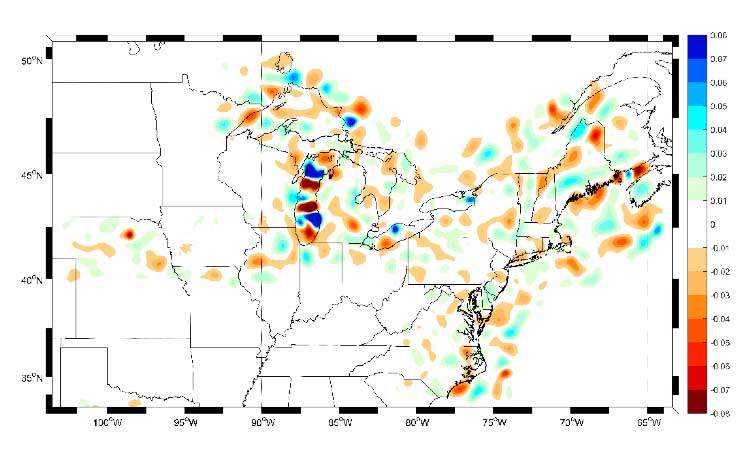
    Figure 4. Northeast – Contribution of GRAV-D airborne gravity [units in cm]

    Figure 5 from Technical Details for xGEOID17 Models

    Photo: National Geodetic Survey

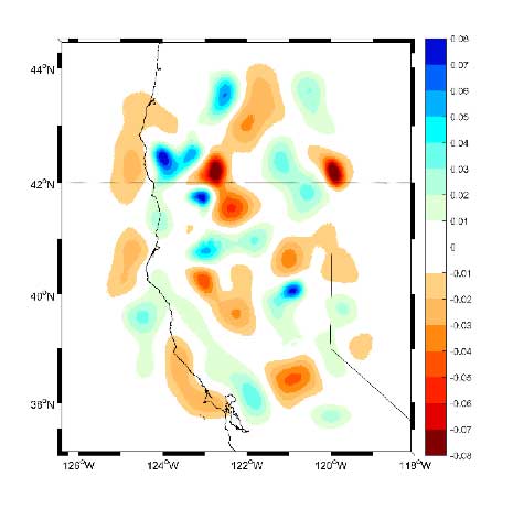
    Figure 5. Pacific Coast – Contribution of GRAV-D airborne gravity [units in cm]

    What does mean to a user today? A station can now have a published ellipsoid height, modeled GEOID12B value, a published NAVD 88 orthometric height, and several xGeoid modeled values. This can lead to confusion if the user is not careful about providing the correct metadata associated with their data and results.

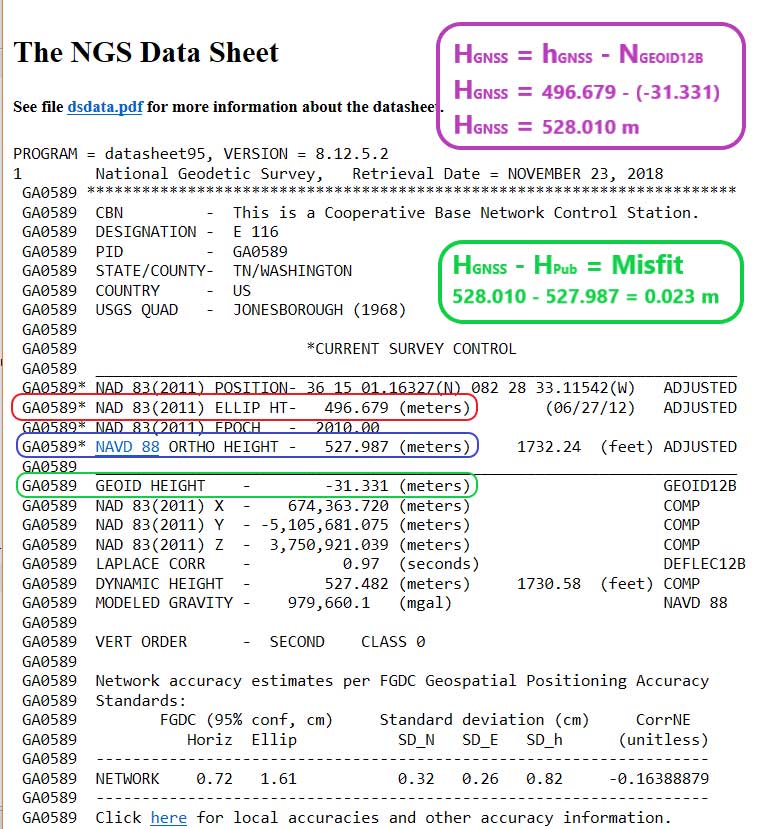
    The box titled “Excerpt from The NGS Data Sheet for Station E 116 (PID GA0589)” provides the output from NGS data sheet retrieval program. The first item to note is that if you compute the GNSS-derived orthometric height (HGNSS) using the formula:

    Equation: National Geodetic Survey Equation: National Geodetic Survey

    the computed value does not equal the published NAVD 88 leveling-derived orthometric height. In this example, the two heights differ by 2.3 cm. As explained in a previous column, GEOID12B is a hybrid geoid model that is distorted to be consistent with NAVD 88 published heights. It is a model and the documentation states that “The relative accuracy of GEOID12B to NAVD88 is characterized by a misfit of +/-1.7 centimeters nationwide.” The box titled “Excerpt from The NGS Data Sheet for Station E 116 (PID GA0589)” provides the computations and the results.

    Excerpt from The NGS Data Sheet for Station E 116 (PID GA0589)

    Data: National Geodetic Survey

    Users can also obtain a xGeoid18B value for the station. The box titled “xGeoid18 Output for Station E 116 (PID GA0589)” provides the output of the xGeoid18 using NGS’ xGeoid18 interactive web service. It should be noted that the xGeoid18 output only provides the NAVD 88 orthometric height using GEOID12B; it does not include the published NAVD 88 orthometric height from the NGS Datasheet.

    xGeoid18 Output for Station E 116 (PID GA0589)

    Note: The GRS80 ellipsoid is used for both NAD83 and IGS08.
    Data: National Geodetic Survey

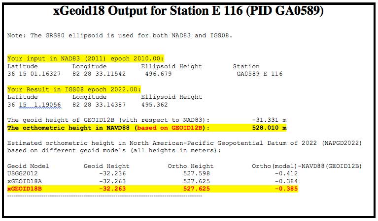
    The box titled “Different Height Values for Station E 116 (PID GA0589)” provides three different height values that are currently available from NGS web services. These different heights could lead to confusion if users are not careful. Most users won’t be using the experimental geoid interactive web service to compute an estimate of an orthometric height but all users should provide the appropriate metadata to avoid any confusion.

    Different Height Values for Station E 116 (PID GA0589)

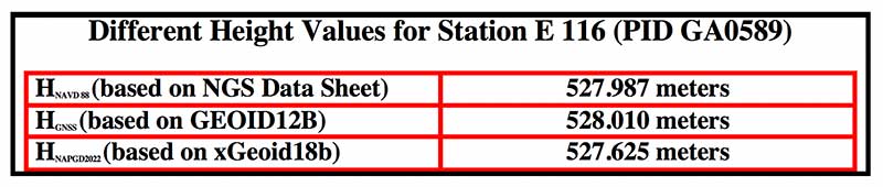
    Chart: National Geodetic Survey Chart: National Geodetic Survey

    The hybrid geoid model GEOID18 is currently being developed and is not ready to be published, but there is a web page that highlights that it will replace GEOID12B in early 2019 [see box titled “Hybrid GEOID18 Website“] GEOID18 values will be similar to GEOID12B because both hybrid geoid models are made to be consistent with published NAVD 88 values. Saying that, there will be differences especially in areas where the GPS on BMs program identified stations that have moved since the last time they were leveled and, therefore, they were not used in GEOID18.

    Hybrid GEOID18 Website

    Photo: National Geodetic Survey Photo: National Geodetic Survey

    My last column provided an update and status report on stations observed in support of the 2018 GPS on BMs program. Many stations with potential invalid published orthometric heights have been identified by the GPS on BM program. This information will be very useful to the surveying and mapping community as well as to NGS. Once NGS publishes the next hybrid geoid model, GEOID18, OPUS results will probably provide an estimate of the NAVD 88 orthometric height computed using GEOID18 similar to what it does now using GEOID12B. In my opinion, the results of GEOID18 will be better than GEOID12B in most areas of the United States and will be helpful in identifying stations that have moved since they were last leveled.

    NGS’ official date for accepted data for inclusion in the next hybrid geoid model, GEOID18, ended September 21, 2018. Continuing to submit your results to OPUS Shared will provide a way for others to analyze the results to determine whether a station has an issue that requires attention. New OPUS shared results will be very useful for evaluating the reliability of the model. After the hybrid geoid model, GEOID18, is published, NGS’ GPS-on-Bench-Mark Program will expand to include other regions and will focus on data to improve NGS datum transformation tools. Further columns will address differences between GEOID12B and GEOID18 after GEOID18 officially replaces GEOID12B.

  • Abstract submissions open for ION GNSS+ 2019

    Abstract submissions open for ION GNSS+ 2019

    Logo: ION GNSS+ 2019ION GNSS+ 2019 organizers are accepting abstracts for the conference, which is set to take place Sept. 16-20 in Miami.

    The conference, themed, “GNSS + Other Sensors in Today’s Marketplace,” will feature two tracks: the commercial and policy tracks and research track.

    The commercial and policy tracks cover mass market and commercial applications, current status and future trends in GNSS, and high performance and safety critical applications. The research track will cover autonomous systems technology, robust multi-sensor navigation and advanced GNSS.

    According to show organizers, authors whose abstracts are accepted in these sessions (either as a primary or as an alternate presenter) will have the option to have their paper peer-reviewed.

    View instructions on submitting an abstract here.

    ION GNSS+ is a technical meeting and showcase of GNSS technology, products and services. The show gathers international leaders in GNSS and related positioning, navigation and timing fields to present new research, introduce new technologies, update current policy, demonstrate products and exchange ideas.

    Check out GPS World‘s ION GNSS+ 2018 coverage here.

  • Registration open for 35th Space Symposium

    Registration open for 35th Space Symposium

    Logo: Space FoundationRegistration has opened for the 35th Space Symposium, sponsored by the Space Foundation and taking place April 8-11 in Colorado Springs, Colorado. The Space Symposium provides a forum to discuss, address and plan for future achievements in space.

    According to show organizers, the event represents all sectors of the space community from multiple spacefaring nations, including space agencies; commercial space businesses and associated subcontractors; military, national security and intelligence organizations; cyber security organizations; federal and state government agencies and organizations; research and development facilities; think tanks; educational institutions; space entrepreneurs and private space travel providers; businesses engaged in adapting, manufacturing or selling space technologies for commercial use; and media that inspire and educate the general public about space.

    The event will feature a number of speakers from NASA, Raytheon, the U.S. Air Force, the Canadian Space Agency, the Mexican Space Agency, the Korean Aerospace Research Institute and more.

    Attendees can also choose from a number of sessions, as well as purchase tickets for a variety of networking opportunities, including the Corporate Partnership Dinner, General James E. Hill Lifetime Space Achievement Award Luncheon, Women’s Global Gathering Luncheon and Space Technology Hall of Fame Luncheon.

  • Lidar USA integrates Z+F scanners for mobile mapping

    Lidar USA integrates Z+F scanners for mobile mapping

    The Z+F Profiler is the latest addition to Lidar USA's HiWay Mapper series. Photo: Lidar USA
    The Z+F Profiler is the latest addition to Lidar USA’s HiWay Mapper series. Photo: Lidar USA

    Lidar USA has integrated Z+F scanners for mobile mapping into its product line.

    According to the company, the Z+F Profiler is a high-speed, 360-degree scanner that provides more than 1 million points per second at up to 200 profiles per second with a range of nearly 120 meters. This product is the latest addition to the company’s HiWay Mapper series.

    The company also integrated the Z+F Imager, which can be transformed into a mobile system to maximize the use of the scanner. This allows companies to provide mobile mapping services with the highest accuracy — at a reduced cost — while maintaining backward compatibility for static scanning, the company said.

    Lidar USA, also known as Fagerman Technologies and based in Huntsville, Alabama, specializes in laser scanning, photogrammetry, instrumentation and geomatics.

    Z+F USA, Inc. is the United States subsidiary of Z+F GmbH Germany. It manufactures high quality control equipment, wire ferrules and laser scanners.

  • 2018 Satellites Leadership Award presented to Giuliano Gatti

    Javier Benedicto accepted the Satellites Leadership Award on behalf of Giuliano Gatti of the European Space Agency during GPS World’s 2018 Leadership Dinner and Awards Ceremony.

  • John Raquet receives 2018 Services Leadership Award

    During the GPS World Leadership Awards dinner, Spirent Federal’s Justin Eldredge presented John Raquet, professor at the Air Force Institute of Technology, with the Services Award.

  • 2018 Products Leadership Award goes to Septentrio team

    At the 2018 GPS World Leadership Awards ceremony, Jean-Marie Sleewaegen from Septentrio accepted the Products award, jointly on behalf of his colleagues Tom Willems, Andrew Simsky and Wim de Wilde.

  • Logan Scott accepts the 2018 Signals Leadership Award

    Logan Scott of LS Consulting received the 2018 Signals Award. Joe Rolli from Harris Corporation was on hand during the GPS World Leadership Dinner and Awards ceremony to present the award.