Tallysman’s Allen Crawford offers an overview of the company’s recently launched helical antennas, which include the HC871, HC872 and HC600, at Xponential 2019, which took place April 29-May 2 in Chicago.
Author: Allison Kral
-
Auterion showcases product portfolio at Xponential 2019
Auterion, an open-source software company, showcased its product portfolio, which includes Enterprise PX4, at Xponential 2019. According to the company, Enterprise PX4 is a software that powers the drone, keeps it away from obstacles and collects the data you need.
-
Xsens debuts MTi 600-series of inertial sensors at Xponential 2019
Xsens launched its MTi 600-series of inertial sensors at Xponential 2019, which took place April 29-May 2 in Chicago. At the show, the MTi 600-series won a Technology Innovation Award from the Association for Unmanned Vehicle Systems International.
-
FlytBase launches FlytGCS at Xponential 2019
FlytBase debuted its FlytGCS, a cloud-based remote drone operations solution, at AUVSI Xponential 2019, which took place April 29-May 2 in Chicago.
-
Attollo Engineering introduces WASP-200 laser rangefinder

According to Attollo Engineering, its WASP series of rangefinders are designed to measure ranges at a rate of up to 10,000 points per second. (Photo: Attollo Engineering) Attollo Engineering, a privately-held company focused on the design and manufacturing of laser sensing and infrared imaging devices, launched the WASP-200 LRF, a laser rangefinder with varied configurations. According to the company, its WASP series of rangefinders are designed to measure ranges at a rate of up to 10,000 points per second with remarkable accuracy and precision in a tiny package.
The WASP-200 LRF can be used for precision agriculture applications and as a proximity-to-ground sensor onboard small or large unmanned aerial vehicles. It has 1-centimeter resolution and 10-centimeter accuracy, the company added. In addition, the laser rangefinder is compatible with the Collins Aerospace Piccolo (CAN Bus and RS-232) and Pixhawk drivers.
The WASP series of rangefinders also feature single-shot laser ranging for fast scanning and moving platforms; programmable burst mode averaging; an IP 67 option; connector options, including pigtails; durable molded ABS plastic housing; and integrated back or front mounting.
According to Attollo Engineering, the rangefinders are suitable for a number of applications, including robotics and drone, sense and avoid, industrial automation, height and distance measurements, and maritime operations.
Attollo Engineering will be showcasing the WASP-200 LRF at booth 2604 at AUVSI’s Xponential 2019 in Chicago.
-
Self-driving work zone vehicles enhance safety

Screenshot: Kratos Defense & Security Solutions/Royal Truck & Equipment ATMA brochure Kratos Defense & Security Solutions, a developer of advanced unmanned system technologies, has teamed with Royal Truck & Equipment, which builds Truck Mounted Attenuator (TMA) vehicles and highway safety systems, to deploy the Autonomous Truck Mounted Attenuator (ATMA), a self-driving work zone vehicle. The ATMA is an autonomous vehicle that uses driverless technology.
According to the company, highway workers are routinely placed in high-risk situations, but are at especially high risk when assigned to drive a TMA vehicle. The TMA vehicle, also known as an Impact Protection Vehicle, is a truck that follows behind slow moving highway maintenance vehicles as a human-driven mobile crash barrier absorbing the impact of traffic accidentally entering the work zone.
“Driving a TMA is extremely dangerous and drivers are at serious risk of lifelong injury, painful rehabilitation and even death,” said Maynard Factor, business development director at Kratos Defense. “To eliminate this dangerous assignment, Kratos Defense developed the Autonomous TMA (ATMA) by retrofitting standard TMA vehicles with driverless technology to enable unmanned operation.”
The first ATMA systems were deployed in 2017 and have since then been deployed across the United States and Europe. The unmanned ATMA operates in a multi-vehicle leader/follower configuration with a human driven highway maintenance vehicle, the companies said. In the leader/follower configuration, the system enables the maintenance vehicle (leader) to transmit navigation data via encrypted V2V communications to the ATMA (follower). From there, the ATMA uses the data to follow the leader, unmanned, as it travels along the route.
The ATMA systems features component redundancy, an active safety system, high accuracy GPS/GPS-denied navigation, encrypted V2V communications, and multi-modal front and side-view obstacle detection, the companies added. It also includes a user interface that provides system feedback, situational awareness, multi-camera views and operator controls.
“Highways are becoming increasingly dangerous due to distracted drivers texting, following too closely, falling asleep, etc., and work zone fatalities from traffic-related crashes average in the hundreds per year,” Factor said. “Our main goal in developing the ATMA was to increase worker safety by removing them from behind the wheel of a vehicle deployed for the sole purpose of operating as a crash barrier.”
Kratos Defense & Security Solutions will be exhibiting at AUVSI’s Xponential 2019 at booth #226.
-
Mobilicom to present smart drone solutions at Xponential 2019
Mobilicom’s SkyHopper VU remote viewing terminal is specifically designed for commercial and industrial drones and robotics. (Photo: Mobilicom) Mobilicom Ltd., a global mission-critical-communications solution provider, will present its SkyHopper end-to-end solutions for smart drones and robotics at the Association for Unmanned Vehicle Systems International’s Xponential 2019 trade show.
According to the company, SkyHopper brings all the key components that turn a drone into a smart drone. The SkyHopper product suite includes communication data links, cybersecurity and encryption that has been validated by the Israel Ministry of Defense and other government organizations; video processing; controllers and viewers.
The product line includes the SkyHopper PRO bi-directional data link, SkyHopper PRO V integrated video processing, SkyHopper ControlAir ruggedized controller and the SkyHopper VU remote viewing terminal.
According to the company, the SkyHopper PRO bi-directional data link delivers long range and non-line of sight communication that supports multiple transmission modes. The SkyHopper PRO V includes a dual-camera input, three camera interfaces, dual built-in video encoders and decoders, and local recording ability. The SkyHopper ControlAir allows users to control a drone or robot, as well as transmit or view a video and data while operating in air and ground missions. Finally, the SkyHopper VU offers a mobile HD video and telemetry receiver terminal for multiple viewers, specifically designed for commercial and industrial drones and robotics.
“We have done our homework in understanding what our customers need in order for their drones to successfully execute their missions,” said Oren Elkayam, CEO of Mobilicom. “As a result, while others focus on offerings for today, we offer solutions also essential for the future survival and scalability of commercial drones of robotics. With proprietary drone cybersecurity and radio technology and a highly experienced customer success team, SkyHopper has maintained a strong base of over 50 customers and counting.”
According to Mobilicom, its goal is to enable commercial drone and robotics manufacturers to increase their chances for success by focusing on their own business objectives, reducing time to market and minimizing resource expenditures.
-
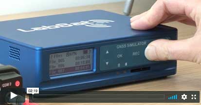
LabSat 3 Wideband — Record & Replay 20 satellite signals simultaneously
LabSat 3 Wideband captures and replays more GNSS signals at much higher resolution than before.
With three channels, a bandwidth of the 56Mhz and 6-bit sampling (3-bit I & 3-bit Q), LabSat 3 Wideband can handle almost any combination of constellation and signal that exists today, with plenty of spare capacity for future planned signals.
-
Schriever Air Force Base releases GPS Week Number Rollover guidelines
The 50th Space Wing Public Affairs office of Schriever Air Force Base has established and posted guidelines, known as Interface Specification GPS-200 (IS-GPS-200), for receiver manufacturers to ensure continued capability during the April 6 GPS Week Number Rollover on Coordinated Universal Time derived from GPS devices.
According to the 50th Space Wing, users should be aware of the upcoming GPS Week Number Rollover as it may impact receivers that are not manufactured in compliance with IS-GPS-200 specifications.
The GPS Week Number count began around midnight on Jan. 5, 1980. Since then, the count has been incremented by one each week and years later broadcast as part of the GPS message. One of the GPS week number fields in the legacy navigation message counts from zero to 1,023 weeks. At the completion of every 1,024 GPS weeks, the field rolls from 1,023 to zero and starts counting again.
The first occurrence took place the evening of Aug. 21, 1999, and the message field rolled to zero at midnight GPS time.
The next similar GPS Week Number Rollover is set to take place April 6.
“We appreciate the four billion people around the world who use GPS signals on a daily basis, which is why we are transparent in providing detailed guidance on use for compatibility,” said Lt. Col. Stephen Toth, 2nd Space Operations Squadron commander.
Civil GPS users are encouraged to submit reports of GPS problems to the Coast Guard Navigation Center; civil aviation users are encouraged to report GPS anomalies to the Federal Aviation Administration; and military users should contact the GPS Operations Center.
-

Israel Aerospace Industries releases anti-jammer for ground GNSS systems
Photo: Israel Aerospace Industries Israel Aerospace Industries (IAI) has unveiled ADA-O, a new version of its ADA system that prevents GNSS signals from being jammed.
ADA-O is designed for armored vehicles and other larger land and sea platforms. According to the company, it can be integrated with ease to protect navigation, telecommunications, command-and-control and other systems. The land platform can be readily integrated in a range of platforms, providing a unique operational response to helps telecom, navigation and C&C systems, the company added.
“ADA and its new derivative ADA-O for land platforms is an important complement for every platform that uses GNSS receivers in general — and GPS in particular — and a vital tool for every modern army,” said Boaz Levy, general manager and executive Vice President of IAI’s Systems, Missiles & Space Group. “Understanding the unique operational needs of land systems allowed us to perform the required modifications on IAI’s airborne anti-jam system so as to provide an advanced technological solution to the operational challenges facing the forces in the different platforms.
Israel Aerospace Industries delivers technologies and systems in for the air, space, land, naval, cyber, homeland security and ISR industries. IAI develops, produces and supports complete systems — from components, sensors and subsystems all the way to large-scale, fully-integrated systems of systems.
-
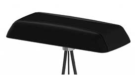
Mobile Mark launches low-profile combination antenna
Photo: Mobile Mark Mobile Mark Antenna Solutions has introduced the LLPG304 Series, a low-profile combination antenna that covers LTE & FirstNet, UHF and GNSS. According to the company, this three-cable surface mount antenna is designed specifically for public safety applications.
The broadband communications element covers 694-4200 MHz, including bands for cellular, LTE, FirstNet, and 5G-ready applications such as Citizen Band Radio Services at 3.7 GHz, the company added. The antenna also offers 3 dBi peak gain from 694-960 MHz and 4 dBi peak gain from 1710-4200 MHz.
The UHF element on the LLPG304 Series antenna covers the 450-470 MHz band with 3 dBi gain, and the GNSS geolocation element covers both GPS and GLONASS (1575 & 1602 MHz). It measures 9×3.5×1.25 in.
“The LLPG304 represents a very significant breakthrough in antenna coverage for the public safety community,” said Michael Berry, president and CEO and Mobile Mark. “This low profile, compact antenna offers both FirstNet coverage and traditional UHF Land Mobile Radio coverage.”
The LLPG304 is designed to meet industrial and military shock and vibration standards, including IEEE1478, EN 61373, MIL-810G and TIA 329.2-C.
-
Blue Marble Geographics updates Global Mapper GIS software

Global Mapper v.20.1 offers a new zoom tool in the path profile view. (Photo: Blue Marble Geographics) Blue Marble Geographics has released Global Mapper v.20.1, the latest version of its GIS software. According to the company, version 20.1 offers a wealth of new and updated geospatial tools, as well as performance improvements throughout the application.
Enhancements to version 20.1 include a new zooming function in the path profile window, a digitizer tool for automatically closing gaps between features and, for lidar module users, a point proximity query function.
Global Mapper’s path profile tool, which is used to create a cutaway view of a terrain layer or point cloud, now offers a simple way to zoom in the view for a close-in perspective of a specific area, the company said. It also now includes a new legend display that differentiates each individual layer when multiple overlapping surfaces are displayed.
The software’s digitizer now includes a simple tool for eliminating slivers or overlapping areas from adjacent features, ensuring the topological integrity of the data. In addition, users can now use an added option that allows the establishment of a default projection, with every imported layer automatically reprojected to adhere to this system.
Finally, version 20.1 release offers new and upgraded functionality in the lidar module. The module now features a proximity search function that highlights points of a particular classification within a certain distance of other point types or line features.
“The release of version 20.1 of Global Mapper provides a perfect illustration of Blue Marble’s unique, user-focused development philosophy,” said Blue Marble’s President Patrick Cunningham. “Each of the major new features and functions, including the new Path Profile tools and lidar proximity querying, is directly attributable to specific requests from our customers. We encourage all Global Mapper users to continue this line of communication to ensure that the software is meeting everyone’s needs.”


