Location, principally provided by GPS/GNSS, plays a key role alongside deployment of 5G cellular networks, in the realization of the internet of things (IoT).
A free webinar hosted by GPS World on May 17 will cover how location plays a role in the internet of things. The webinar will include presentations by Fergus Noble, co-founder and CTO of Swift Navigation; Oliver Cameron, co-founder and CEO of Voyage; and Steve Thompson, senior director and office of the CTO of Acorn Technologies.
During his presentation, Noble will highlight the benefits of integrating a cloud corrections service with high-precision GNSS receivers. He also will provide an understanding for users of GPS about how high-precision GNSS receivers benefit from a cloud corrections service, including high-precision results in seconds and increased geographic range.
Cameron will cover why private cities make for the perfect first deployments of self-driving cars and Thompson will offer an overview on cellular positioning technology for ultra-low-cost, ultra-long-battery-life IoT applications.
In late 2017, Northrop Grumman and San Diego Zoo Global planned and carried out a research mission to map Arctic sea ice formations to learn more about polar bear habitats — proving autonomous technology is making a name for itself as a key tool in conservation projects.
The project began as a competition between teams of Northrop Grumman employees who aimed to find a way to map Artic sea ice formations, and the winning team — Team Polar Eye from Melbourne, Florida — earned the privilege of using its technology to map the area.
“The project name is Wildlife Challenge,” said Charlie Welch, materials and process engineer at Northrop Grumman and technical lead of the Wildlife Challenge. “It’s a collaboration between San Diego Zoo Global and Northrop Grumman to help bring really high-level technology to the San Diego Zoo’s conservation efforts — specifically unmanned technology.”
Polar bears have to wait for the ice to freeze to hunt, and the zoo wanted to repeatedly map the same area in the Artic to learn more about the ice, including how it’s freezing, where a polar bear is on the ice and what the ice looks like, such as its thickness. The zoo then planned to use this data to predict how changes in the ice — and overall climate change — will affect the polar bears.
To carry out the project, the Northrop Grumman team developed a drone that could handle the freezing temperatures. The team then flew to Northern Canada to gather the ice data.
“We had to take the drone out to the middle of nowhere, basically, and be confident that this could work and collect critical data on a really key, iconic species,” Welch said. “Half the engineering was designing the logistics of getting our team out there, getting every spare part we could think of and making sure that we could survive out there, along with the system.”
Click on the icon in the top left hand corner to choose the video you’d like to watch.
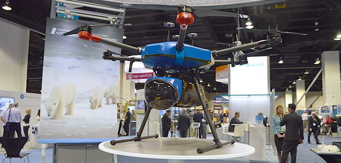
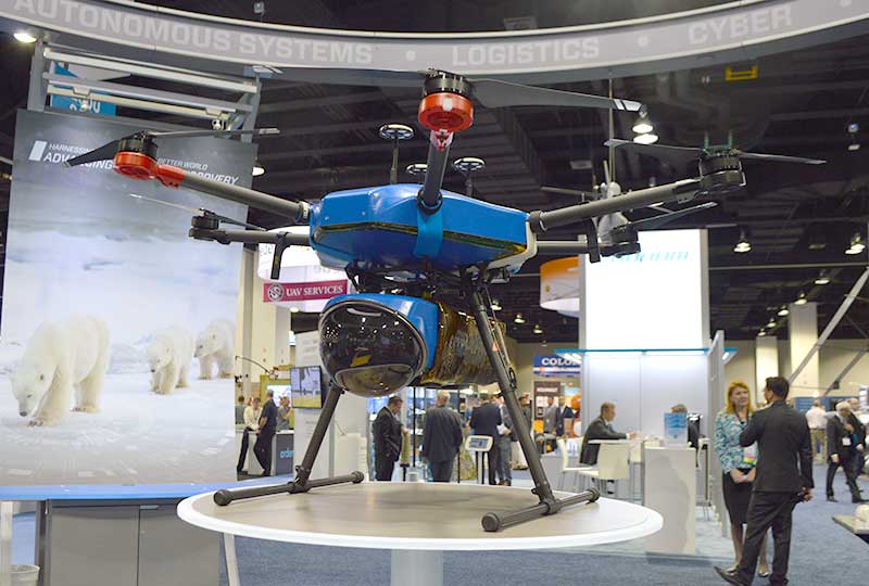
During the 10-day mission, the team used its modified DJI M600 hexacopter drone to capture the data, as well as ground equipment to process the data and ensure the drone was operating correctly. According to the company, the hexacopter platform consisted of six rotors, a triple-redundant navigation system, high-voltage battery packs and a custom payload bay to hold a range of integrated sensors. It was also equipped with a ruggedized thermal shell, designed to withstand temperatures as low as minus-20 degrees Fahrenheit.
“We had to make a few adjustments in the field, as we kind of anticipated,” Welch said. “So we designed the drone to be reconfigurable really easily.”
The Northrop Grumman team used its modified DJI M600 hexacopter drone to capture the ice data. Photo by Allison Barwacz
The team conducted several successful sea ice mapping missions and collected an array of habitat data, including 3D sea ice maps and multispectral data, both collected at sub-centimeter resolution, the company said. Northrop Grumman sent the data to zoo scientists, who are still closely working with the company. Northrop Grumman also donated its hexacopter drone to the zoo so that it be used for other conservation projects.
“We’re keeping in collaboration [with the zoo] to try and figure out what they want to do next from a scientific perspective, and how the data we collected is working out for what their goals were,” Welch said. “We see these innovative projects as a good way to engage our employees and give them the ability to work on projects that are very science-based. We also want to make a positive impact toward STEM (science, technology, engineering and mathematics) and be able to show students how engineering and science fields can be applied in a variety of ways.”
Trimble’s Chris Wheeler offers an overview of Trimble’s GNSS technology, including its latest receiver boards, which include the BD990 and BD992, at Xponential 2018 in Denver.
Septentrio’s Gustavo Lopez offers a rundown on the company’s AsteRx SB ruggedized multi-frequency GNSS receiver at Xponential 2018 in Denver. According to the company, the AsteRx SB can operate in RTK rover or base station mode and, with an on-board 16GB memory, it can log data for offline post-processed PPK.
Spirent Federal Systems’ Kalani Needham discusses the company’s GSS9000 GNSS/GPS simulator at Xponential 2018. Needham also discusses the company’s partnership with Rockwell Collins to develop software that will support M-Code using the Modernized Navstar Security Algorithm.
Laser Technology Inc.’s Clint Cowan offers GPS World a rundown on the company’s laser range finder at Xponential 2018, which took place April 30-May 3 in Denver.
Swift Navigation’s David Fischer gives GPS World an overview of the company’s Skylark GNSS corrections service at Xponential 2018. According to the company, Skylark is cloud-based and delivers affordable, fast, centimeter-level accuracy and eliminates the complexity of deploying and maintaining GNSS networks.
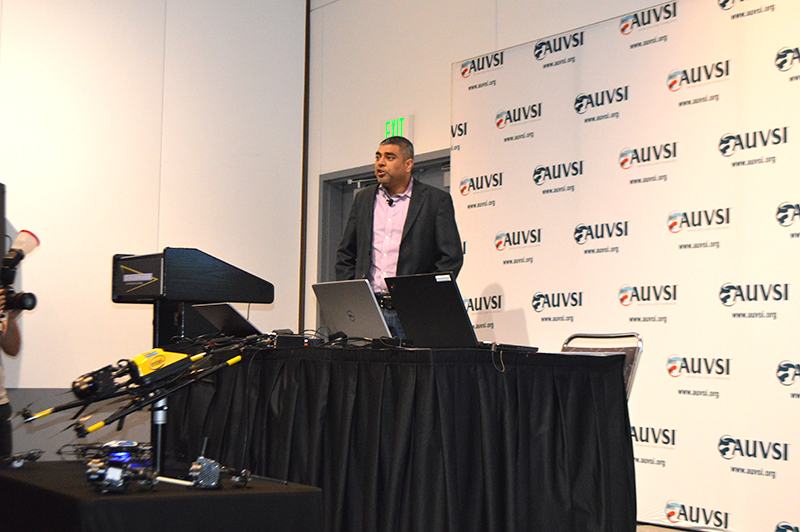
Intel’s Anil Naduri discussed some of the company’s updates at Xponential 2018. Photos by Allison Barwacz
Intel shared a number of updates at a presentation during AUVSI’s Xponential 2018, which took place April 30-May 3 in Denver. Among the company’s latest developments are its Insight Platform, Mission Control and Falcon 8+.
Intel Insight Platform
Intel’s Insight Platform is a digital asset management system that enables aerial data management and analysis. It allows customers to store, share and manage data that commercial drone systems collect. According to the company, the platform is designed to reduce costs, improve efficiency and fuel growth.
The Intel Insight platform takes the aerial data and can generate 2D and 3D models, take measurements and run data analytics.
“The asset-based approach allows you to tag repeated flights over the same location, and that provides a great foundation for you,” said Anil Nanduri, vice president and general manager of the Intel drone team.
Intel Mission Control
Intel’s Mission Control is the company’s next-generation flight planning software for its Falcon 8+ drone. According to the company, it is designed to increase workflow efficiency and enhance automation of drone flights for commercial missions.
Mission Control allows Falcon 8+ drone operators to create 2D and 3D flight plans for commercial surveying, mapping and inspection missions.
Intel Mission Control software is currently in beta testing with customers, Intel said.
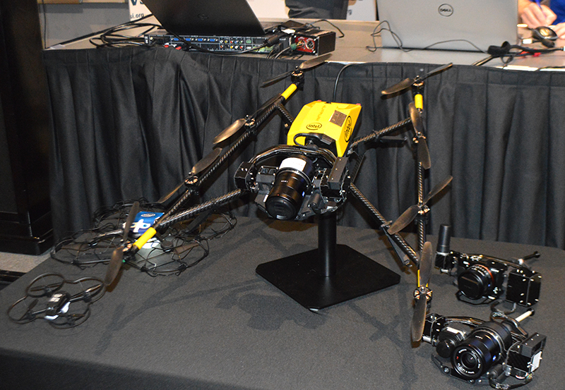
Falcon 8+ drone
Intel revealed three new payloads for its Falcon 8+ at Xponential. Photo by Ryan Gerard
During the presentation, Intel revealed three new payloads, as well as distance hold and distance guard features, for its Falcon 8+ drone.
The three new payloads are designed for inspection, surveying and mapping applications. According to Intel, the Falcon 8+ also now boasts distance hold and distance guard features on the Intel Imaging and Duel Imaging payloads. The distance hold feature allows the drone to maintain and hold a set distance from certain obstacles during inspections, and distance guard is another obstacle avoidance feature.
The company also shared how the drone has assisted with natural disasters and safety inspections. The Falcon 8+ played a role in disaster relief for the Sonoma County fires, as well as data recovery following Hurricane Harvey in Houston.
The drone also assisted with a gas terminal inspection in Scotland, as well as with Arctic wildlife research.
“Drones are going to be the most transformative business technology in the coming generation,” Nanduri said.
Phase One Industrial’s Steve Cooper offers a rundown on the company’s iXM-100MP metric camera at AUVSI’s Xponential in Denver. According to the company, the iXM-100MP was engineered for for UAV-imaging missions.
Harxon Corporation’s Elaine Tao offers a rundown on the company’s HX-DU2017D frequency-hopping modem at Xponential 2018 in Denver. According to the company, this modem has a frequency of 902-928MHz.