Mitch Narins, principal consultant & owner, Strategic Synergies LLC
Recently there have been conversations within the world’s position, navigation and timing communities regarding the use of the term “Gold Standard.” Many systems aspire to be a Gold Standard, but what does this mean and how should one rightfully claim this meritorious distinction? For me, to be called a Gold Standard, a system must meet a number of hard and soft performance requirements that instill users with trust and confidence. What are these performance metrics., and how should we measure them?
I propose that for a PNT system to be a Gold Standard, it must embody and embrace three basic operational aspects in its vision, mission and goals, which drive its design, development and operation:
Requirements. First, a PNT Gold Standard system must have clear, concise, published and independent operational requirements, established through recognized and appropriate standards — that is, the PNT “promises” of accuracy, availability, integrity, continuity and coverage provided by the system are available to all users, and any changes to these “performance requirements” are communicated and implemented in a formal and transparent process.
Monitoring. Next, a PNT Gold Standard must continuously monitor the system “health” to ensure that it is meeting all of its promised requirements (accuracy, availability, integrity, continuity and coverage). The measurements and monitoring information must be available to all users so they can, with confidence, independently verify performance in support of their missions and needs.
Transparency. Finally, and most importantly, a PNT Gold Standard must not only maintain transparency during normal operations, but at the most crucial times when the PNT system is not meeting its promised performance. When “things go wrong,” user communications and constant, continuous, and reliable information flows are essential to retaining trust (that is, the measure of the system operator’s integrity). “We don’t know what happened yet, but we will let you know as soon as we do” is acceptable; saying “no comment” is not. As soon as the cause of the problem is known, it must be promptly shared, in detail, along with the schedule for restoration of normal operations. All changes that will be implemented to preclude such an occurrence in the future and all lessons learned must also be communicated openly and honestly to users.
So, what is a PNT Gold Standard? It is a system that makes operational promises based on known and controlled standards and requirements and openly shares how performance against those promises is being monitored and assured. It is a system defined by mission, values, standards and operating principles that is committed to free and open communications when promised performance is being met and when it is not. It is a system that transparently documents, communicates, investigates and reports health and status to users without delay. It is a combination of known, measured and exceptional performance provided by a system operated with open, honest, inclusive, transparent and complete communications that evoke user trust. For me, that is what it means to be a PNT Gold Standard.
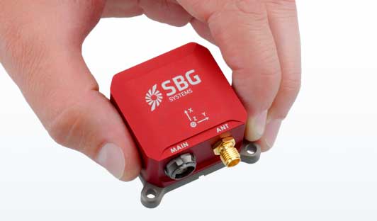
SBG Systems has built a program designed to sponsor student teams participating in competitions, as well as offer discounts for universities and research centers on inertial sensors and post-processing software.
Through the program, the company sponsors students participating in competitions in various fields, such as robotics, autonomous vehicles, UAV, rockets, unmanned and solar boats and more. This includes support during the competition, as well as during the installation of SBG’s latest inertial navigation systems in the teams’ vehicle prototype, the company said.
SBG’s Ellipse series is also eligible through its education program. The series is composed of SBG’s miniature inertial measurement units, attitude and heading reference systems and inertial navigation systems. In addition, the entire product line has been renewed. The new Ellipse INS/GNSS embeds a quad constellation, dual frequency, and dual Antenna RTK GNSS receiver to bring centimetric position and higher accuracy orientation in the smallest package, SBG added.
In addition to being compatible with CAN and ROS, the Ellipse Series’ sensors are compatible with SBG’s Qinertia Post-Processing Software, the SBG Systems’ in-house INS/GNSS post-processing software. Qinertia allows users to replay, analyze, improve their trajectories and access RTK corrections worldwide to bring their project to the centimetric accuracy.
SBG Systems designs and manufactures MEMS-based inertial motion sensing solutions. According to SBG, its products are ideal solutions for industrial and research projects such as unmanned vehicle control, antenna tracking, camera stabilization and surveying applications.
I spent much of the 1980s working for Magnavox Government & Industrial Electronics Company, which held a number of patents on the GPS system and also developed prototype GPS user sets for the military. I, and others at the company, often gave presentations to industry groups talking about the many commercial and consumer applications for which GPS would be used as the cost and size of GPS receivers declined. By the early 2000s, the applications we had envisioned had been far surpassed.
In the early 1990s, I spent several years at Teletrac, now Teletrac Navman, which was beginning to market a vehicle tracking solution based on its own proprietary time-difference-of-arrival (TDOA) technology, using in-vehicle devices and metro-area-based receiving/transmitting towers. One day, the co-founder and chairman of the company roamed into my office for an update on sales and marketing progress. I changed the subject and, at some risk to my job, said “Dennis, the future of location technology is GPS. It will not just be used to locate vehicles, but even cellular phones. With teams of talented engineers focused on reducing the size and cost of receivers and adapting them to specific applications, ‘the sky is the limit’.” He didn’t fire me, but spent the rest of our discussion telling me why I was wrong — that GPS receivers would always be too large, too expensive, too susceptible to signal blockage, and other limitations.
Thirty years later, the applications I had envisioned for GPS have been greatly surpassed and are constantly expanding. In recent years, my primary focus has been on researching the growth and trends of the commercial telematics market in the U.S. and abroad. Today, in the U.S. alone, some 16 million GPS devices are being used to monitor fleet vehicles and assets, such as trailers and heavy construction equipment. Even in the face of the COVID-19 pandemic, the market remains stable and is on track to grow for the year.
In the future, GPS will play an essential role in the deployment of autonomous vehicles, with help from other technologies needed to optimize location accuracy and reliability. My hat is off to the founding fathers of GPS who include some of the most brilliant technologists of this era.
Walmart is teaming up with drone delivery company Zipline to launch a drone delivery operation in the United States. According to Walmart, this first-of-its-kind drone delivery service will make on-demand deliveries of select health and wellness products with the potential to expand to general merchandise.
Trial deliveries will take place near Walmart’s headquarters in Northwest Arkansas. The trials will use Zipline’s proprietary technology.
Zipline will operate from a Walmart store and can service a 50-mile radius, Walmart said. The company’s launch-and-release system allows for quick on-demand deliveries in under an hour, and it also eliminates carbon emissions, Walmart added.
Zipline began operating in 2016 in Rwanda, primarily focusing on the on-demand delivery of medical supplies. According to Zipline, it has safely delivered more than 200,000 critical medical products to thousands of health facilities serving more than 20 million people across multiple countries.
The operation will likely begin in early 2021, Walmart said.
GNSS has had a major impact on many different industries and market segments, but I believe that the incorporation of GNSS into cell phones has impacted more people around the world than any other. It’s almost hard to remember back in the last millennium when the idea of putting a GPS receiver into a cell phone was first contemplated. Back then, we were just starting the transformation from 1G phones (analog) to 2G phones (digital), and the whole idea of 911 for mobile phones was a huge hurdle facing the entire industry. Three small startups (SiRF, SnapTrack and Global Locate) were all founded with the seemingly impossible dream of putting GPS into every cell phone to provide location information for E911 and other commercial applications. Back in those days, we were trying to convince operators and the FCC that GPS could provide location accuracy better than the 150-meters 67% of the time that the cellular industry was leaning toward with other technologies.
Can you hear me now? A sampling of early cell phones. (Photo: yktr/iStock/Getty Images Plus/Getty Images)
Fortunately for everyone, we were able to convince the industry that GNSS was an answer that should be considered. Today, we see billions of phones around the world with embedded GNSS. Those early phones from Motorola, Nokia, Ericsson and RIM (Blackberry) were truly marvels of engineering development to tightly couple GPS and cellular. Interestingly, none of those phone makers — nor any of those three pioneering companies — exist today, having been subsumed into larger entities due to their success in solving this incredibly complex problem. Those early GPS L1 C/A-only phones have added GLONASS, Galileo, QZSS and BDS, and we are now starting to see support for L5 showing up in smartphones. This has all led to improved availability and accuracy — now not only can we locate E911 calls to the correct civic address for emergency responders, but commercial applications rely on <10-meter accuracy for driving directions, ride sharing and social media applications. Every time I think there is nothing new to do, something always comes along. I’m excited to see what’s next.
According to a report by InForGrowth, the global GPS tracking devices market was valued at $1,567 million in 2018 and is expected to grow at a CAGR of 12.2% during the forecast period 2026.
Increasing demand for fleet telematics and affordable prices of GPS tracking devices are expected to drive the growth of the GPS tracking devices market.
However, the report says, environmental obstacles and non-standard products are expected to impede the growth of the market in the coming years.
The growth of the GPS tracking devices market is attributed to the increasing demand for fleet telematics in the transportation and logistics sector. Government authorities are making rules and regulations for fleet tracking systems in commercial vehicles for improving the safety of passengers, the report said. In addition, vehicle rental companies are deploying an increased number of GPS tracking devices in their fleets.
Next, technological advancements such as self-driving vehicles and connected car technology mainly rely on GPS-based tracking systems for improving the accuracy and reliability of navigation. According to the report, many developing countries, such as India, are focusing on the advancement of their navigation technology. The adoption of 5G communication technology will also help in the advancement of driverless cars technology, which uses GPS tracking devices for movement and route planning.
Finally, the affordability of GPS tracking devices has encouraged market growth, the report said. This in turn has increased competition between manufacturers to develop updated technology-enabled GPS tracking devices.
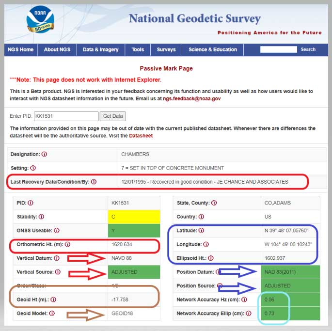
NGS has developed a new beta tool for obtaining geodetic information about a passive mark in their database. This column will highlight some features (available as of Oct. 5, 2020) that may be of interest to GNSS users. It provides all of the information about a station in a more user-friendly format. The box titled “Passive Mark Lookup Tool” is an example of the webtool. The tool provides a lot of information so I have separated the output of the tool into several boxes titled “Passive Mark Lookup Tool — A through D.”
I will highlight several attributes that I believe will be very useful to users, especially users of leveling-derived and GNSS-derived orthometric heights. I’ve highlighted several attributes in the box titled “Passive Mark Lookup Tool — A” that are important to users such as published coordinates, their datum and source, Geoid18 value, GNSS Useable, and the date of last recovery. All of these values are available on a NGS datasheet but, in my opinion, this provides the information in a more user-friendly format.
One calculation that the user can easily compute for marks that have been leveled to and occupied by GNSS equipment, is the difference between the published leveling-derived orthometric height and the computed GNSS-derived orthometric height. This may indicate that the mark has moved since the last time it was leveled to or that its height coordinate has been readjusted since the creation of the published geoid model.
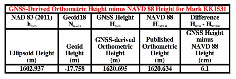
The table below provides the calculation using the data from the box titled “Passive Mark Lookup Tool — A.” The calculation [HGNSS = hGNSS — NGeoid18; Difference = HGNSS — HNAVD 88] has been described in several of my previous columns (this one, for example).
Data: National Geodetic Survey
In this example, the difference between the GNSS-derived orthometric height and the Published NAVD 88 height is 6.1 cm. NGS is looking for comments on this beta webtool so if users would like this computation added to the tool, they should send a comment to NGS using the link provided on the site (This is a beta product. NGS is interested in your feedback concerning its function and usability as well as how users would like to interact with NGS datasheet information in the future. Email us at [email protected].) So, the user should ask the question, did the station move since the last time it was leveled?
Another attribute that would be nice to be part of this tool is which station was used to create the hybrid geoid model. As of Oct. 5, 2020, users have to go to the Geoid18 webpage to get the information. The Excel file and shapefiles provide whether the station was used to create the Geoid18 model. In the case of this example, KK1531, CHAMBERS, the mark was not used in the creation of Geoid18 so NGS felt that the station may have moved and/or the GPS on Bench Mark residual was large relative to its neighbors. See NGS’s technical report on Geoid18 for more information on the creation of Geoid18. The GPS on Bench Mark residual analysis was described in several of my previous columns (see “The differences between Geoid18 values and NAD 83, NAVD 88 values” and “NGS 2018 GPS on BMs program in support of NAPGD2022 — Part 6” for examples).
The webtool provides a map depicting the location of the station, photos (if available), and previously published, superceded values of the mark. See the box titled “Passive Mark Lookup Tool — B.”
In the example of Chambers, KK1531, no photos were available. It would be helpful if a user would provide photos to NGS when visiting this station. (Note: NGS has a webtool for users to submit recovery information about a mark as well as to provide current photos of the station.) The new Passive Mark webtool also provides information about the survey projects that the mark has been involved in such as leveling and GNSS projects.
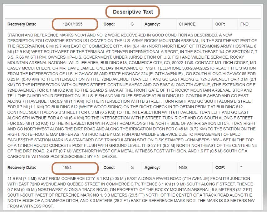
In this example, mark CHAMBERS was leveled to in a 1984 first-order, class 2 leveling project (Leveling Line number L24838/6) and, in 1995, the mark was part of a GNSS project (GNSS Project GPS1010). It also provides all the descriptive text and recovery information (See boxes titled “Passive Mark Lookup Tool – C” and “Passive Mark Lookup Tool – D”).
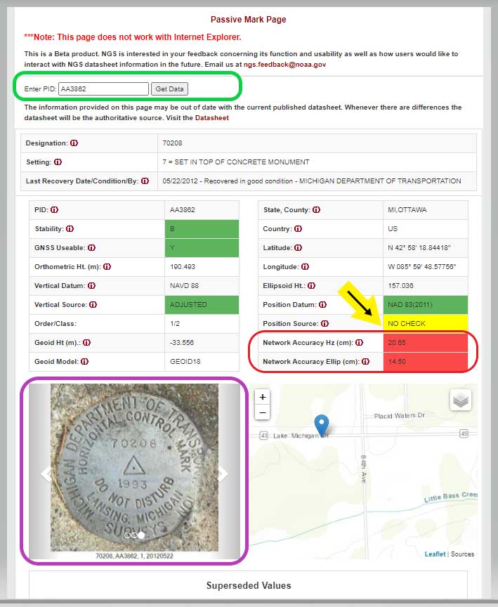
I want to highlight a few other attributes of this webtool. The station, PID AA3862, has an interesting attribute that users should take note of; that is, the NAD 83 (2011) position source is NO CHECK. See box titled “Passive Mark Page for PID AA3862.”
This means that the mark’s NAD 83 (2011) coordinates were determined without redundant observations. This is not a good survey practice but there are times that a project may contain check observations for some purpose or, more likely, the mark did contain other GNSS vector but they were rejected in the final adjustment. Either way, a good survey practice would be for users to verify the coordinates of these marks before using them.
Passive Mark Page for PID AA3862
Data: National Geodetic Survey
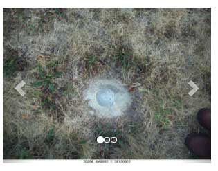
As previously mentioned, the tool provides the location of the station on a map and photos if they are available. This is a really nice feature for anyone searching for the mark. The map can be enlarged as well reduced by clicking on the box. See boxes titled “Passive Mark Page for PID AA3862” and “Photos of Mark PID AA3862.” The box titled “Photos of Mark PID AA3862” provides all three photos of mark PID AA3862.
Photos of Mark PID AA3862
Photo: National Geodetic SurveyPhoto: National Geodetic Survey
Photo: National Geodetic Survey
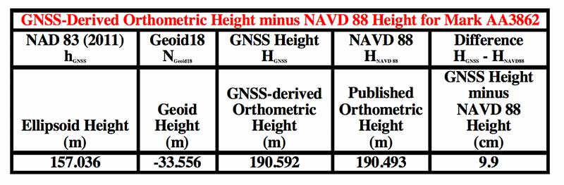
It should be noted, according to the Geoid18 GPS on BMs dataset that users can download, this station, AA3862, was not used in the creation of Geoid18. The table below provides the difference between the GNSS-derived orthometric height and the published NAVD 88 height.
In this example, the difference between the GNSS-derived orthometric height and the published NAVD 88 height is 9.9 cm. Also, the webtool provides the network accuracy values for the station. In this example, the horizontal network accuracy is 20.65 cm and the vertical network accuracy value is 14.50 cm (see highlighted values in box titled “Passive Mark Page for PID AA3862”). These are very large network accuracy values. This should be a flag to anyone that is using this station as control.
Data: National Geodetic Survey
As I previously mentioned, as a beta site, users should verify all information from the site. NGS is requesting feedback on this tool so they can improve it and make it an operational webtool. I encourage everyone to access the tool and check out a few of their favorite marks, and then send an email to NGS informing them of what you like, what you would like to change, and what you would like to see added to the tool.
NGS is releasing this tool as a beta product to get feedback from users. As NGS states in the heading of the tool, they are interested in your feedback concerning its function and usability as well as how users would like to interact with NGS datasheet information in the future. Email NGS at [email protected].
One last item that may be of interest to GNSS users is that NGS, working with the University Corporation for Atmospheric Research (UCAR), developed another online GNSS lesson (see box titled “New GNSS Lesson by NGS and UCAR”). These lessons are free but users must sign up to access the website and lesson.
Believe it or not, I remember clearly when one of my colleagues, at the beginning of 1990 in my office, made me aware of the upcoming GPS World journal. He went through the list of the already-appointed members of the editorial board and found some key names; Vidal Ashkenazi comes now to my mind. Later on, we received the first issue which, I am sure, must be carefully stored in the library of, at the time my employer, the Institute of Cartography of Catalonia (ICC).
I also remember the day we were processing GPS kinematic measurements of an aerial survey conducted with Sercel NR52 and TR5SB C/A-code L1 GPS receivers (one was 33 x 38 x 33 cm3 and 18 kg; the other was even bulkier, and both operated on valves). That was for the new GPS aerial triangulation method.
Shortly after, the application to airborne laser scanning came, and then INS/GPS integration for airborne remote sensing and mobile mapping. Then came the reinforcing high-speed loop of new applications, technology and challenges. The rest is history. An invariant of these 30 years has been that on our tables there were always one or more issues of GPS World. GPS World issues are always around us, part of our offices’ landscapes.
Last but not least, I cannot tell apart the early days of the journal from its founding editor, Glen Gibbons, who has to be credited for about half the life of the magazine. He brought me onboard GeoConvergencia and, later on, when GeoConvergencia was stopped, to GPS World. I used to share with him ideas and results, and he used to scold me about not publishing them in his journal.
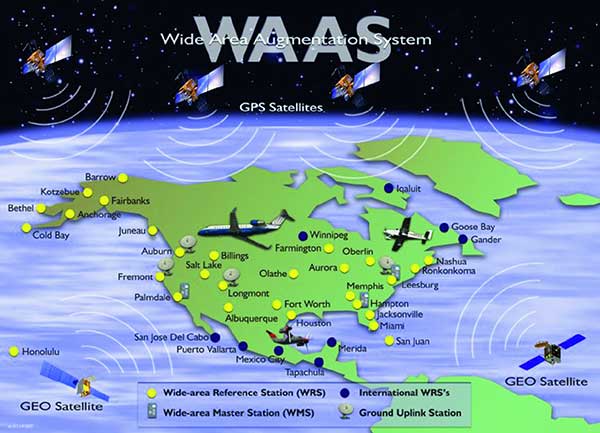
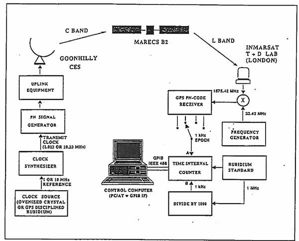
Thirty years ago, NAVSYS was deep into the development of the Wide Area Augmentation System (WAAS). I had the honor of being the chair of the RTCA SC-159 Integrity Working Group, which developed the first concepts for what evolved into three integrity standards for GPS: multi-sensor integration, receiver autonomous integrity monitoring (RAIM) and wide-area differential GPS using a GPS integrity channel (GIC) to broadcast corrections over a geostationary overlay.
NAVSYS, working with Inmarsat Corporation, built the first prototype WAAS SIGGEN equipment, which was deployed at the Coonhilly Coast Earth Station and used to transmit an L-band C/A-code signal over the Inmarsat Atlantic Ocean Region MARECS-B satellite to a software GPS receiver that we had developed and installed at Inmarsat’s Test and Development Laboratory in London.
First Inmarsat Geostationary Overlay Test-Bed, 1991. (Image: NAVSYS)Image: FAA
This evolved into the FAA’s WAAS program, which used the NAVSYS SIGGEN for the initial deployment, test and evaluation. The algorithms developed by NAVSYS were ultimately licensed to Raytheon for use on the operational WAAS and MSAS systems.
GPS World, in conjunction with Spirent Federal Systems, will be hosting a webinar on Oct. 8 that will cover GPS program updates, as well as the program’s role in the Space and Missile Systems Center’s (SMC) space enterprise architecture.
The event will also discuss the effects of COVID-19 and any future plans for the GPS program.
Event speakers will include Col. Ryan Colburn, director of SMC’s Spectrum Warfare Division; Shawn Ryan, BAE Systems Navigation & Sensor Systems director of business development for SMC; Mike Shepherd, associate director of business development at Collins Aerospace Mission Systems; and Christopher Hogstrom, engineer at Spirent Federal Systems.
Col. Ryan Colburn leads a team charged with designing and integrating the United States Space Force’s current and future integrated satellite communications and position navigation and timing enterprise architectures. He works with military, commercial, allied and government partners to ensure SMC is able to design, acquire, integrate and field the space systems needed to support today’s warfighters.
Shawn Ryan provides local leadership for all SMC and Los Angeles Industrial NSS efforts and engagement. NSS, headquartered in Cedar Rapids, Iowa, develops, designs and manufactures the most advanced GPS receivers and anti-jam GPS antenna electronics for military applications.
Mike Shepherd leads integrated business development for A-PNT, FVL, TITAN and JADC2. Previously, he was the senior manager of the ground U.S. military GPS receiver business and managed major accounts for all branches of the U.S. military users of GPS and A-PNT systems.
Christopher Hogstrom joined Spirent Federal in 2020. He currently supports various engineering efforts as well as customer trainings and product demos. He has worked extensively with adaptive beamforming and its applications in GPS anti-jam technologies. Hogstrom received his Bachelor and Master of Science in Electrical engineering from Brigham Young University.
Via, a provider of digital infrastructure for public mobility systems, has acquired Fleetonomy, a developer of fleet management software.
Fleetonomy was founded in 2017 by CEO Israel Duanis and CTO Lior Gerenstein, with the vision of building the next generation of fleet management and optimization platforms, suitable for the challenges and opportunities that came with the shift to fleet-based on-demand services.
According to Via, the purchase accelerates its expansion beyond public transit and strengthens its ability to meet increasing global demand for efficient, flexible solutions for logistics and delivery.
Via’s technology is currently used in more than 150 cities and transit operators across the globe to power intelligent transit and delivery platforms, Via said. The need for essential transit and goods delivery has continued to grow during the COVID-19 pandemic, and Via plans to apply Fleetonomy’s technology and expertise in demand prediction and fleet utilization to advance its digitally-powered logistics solutions.
“As we continue to build the next generation of public transportation and delivery infrastructure, we are proud to partner with Fleetonomy to step into this new phase of growth,” said Via Co-Founders Daniel Ramot and Oren Shoval. “We have been consistently impressed by Israel, Lior and the entire Fleetonomy team, and by the beautifully-designed and exceptionally-engineered products they have created. We share a vision for the future of mobility and look forward to realizing this vision together.”
When I started Racelogic nearly 30 years ago, I could not have foreseen how intrinsically embedded GPS would become in my life. I started out with the goal of supplying electronic control systems to the motorsport world. From traction control systems to paddle shifters for automatic cars, our technology rapidly built a reputation for quality and accuracy. It was this pursuit of accuracy that led me to GPS.
GPS can be used for a wide variety of applications, but still not many people realize just how accurate it is for measuring the speed of a moving object. It was whilst looking for a solution to measure ground speed to use as a reference for a traction control system for a 4-wheel drive rally car that we came across an Ashtech 20-Hz GPS engine and were amazed to find out just how accurate the speed output was. This was a turning point in Racelogic’s history, which led to the development of one of our best-known products, the Velocity Box (VBOX), which is used to measure speed, distance and acceleration of vehicles for use in the test and development of new cars.
It is undoubtedly an exciting time for GNSS. New signals and constellations are delivering a huge improvement in performance, which has spurred the release of new, lower cost, game-changing products into the marketplace. With cm-level position now becoming affordable for almost any application, it will be fascinating to follow how this changes the face of the positioning market, and see what innovations and novel applications will appear.
Delivering solutions to these emerging applications will require agility and flexibility to integrate GPS with sector-specific technology. If this can be combined with solutions that overcome some of the limitations of GPS, then the opportunities are boundless. I for one am excited to see where the next 30 years takes us.