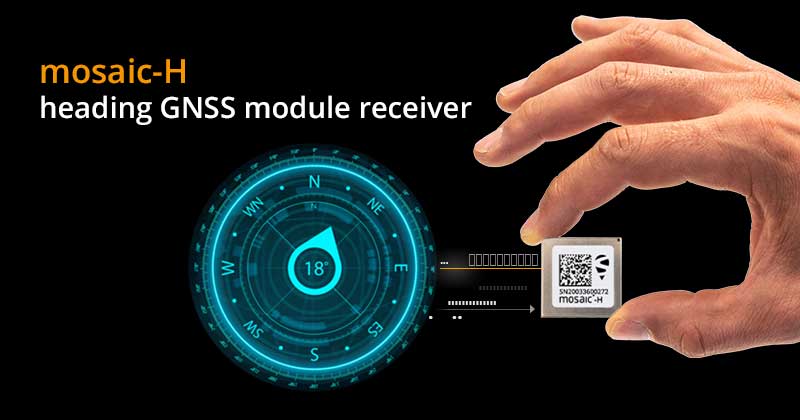
Septentrio has expanded its GNSS module portfolio with the launch of its mosaic-H heading receiver. According to the company, with dual-antenna capabilities, this surface mount module delivers reliable heading and pitch or heading and roll information on top of centimeter-level positioning.
mosaic-H is the new addition to Septentrio’s existing mosaic module family, which already includes RTK and timing modules, as well as modules with integrated GNSS corrections. According to Septentrio, having a single standard footprint across multiple specialized receiver modules enables integrators to create multiple application-specific products based on a single design.
“The mosaic GNSS receivers have set a new performance standard among high-precision GNSS modules,” said Francois Freulon, head of product management at Septentrio. “Adding a second antenna input into the single form factor of mosaic demonstrates Septentrio’s leading position in the high-precision module market. Thanks to its ultra-small dimensions and low power consumption, mosaic-H is the ideal navigation and control solution for robotics, UAVs and autonomous applications which require ultra-robust and secure positioning and heading.”
mosaic-H delivers orientation angles immediately from the start, helping initialize inertial systems which otherwise would require movement before they can measure 3D orientation. INS initialization with GNSS attitude from power-up allows machine trajectory path optimization and fully informed navigation of robotic systems immediately from mission start, Septentrio added.
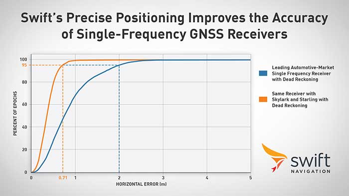
Swift Navigation announced its precise positioning platform can improve the performance of existing single-frequency GNSS positioning, found on most production vehicles today, from the standard average of 3 meters to lane-level accuracy without changing existing hardware and antenna.
According to Swift, these findings are demonstrated during the regular test drives the Swift team conducts to confirm the efficacy of its solutions and software updates. The graph depicts the improved positioning accuracy and availability when a single-frequency receiver is used with corrections from the Skylark precise positioning service and the Starling positioning engine, Swift said. A performance improvement from 2 meters to 0.7 meters for 95% of this mixed-environment drive was achieved on a production vehicle with a low-cost automotive receiver and antenna.
Graph: Swift Navigation
Skylark, Swift’s wide area, cloud-based GNSS corrections service delivers real-time, high-precision positioning, is hardware-independent and is most accurate and seamless when integrated with Starling as a complete solution. Starling is a high-precision positioning engine that works with a variety of automotive-grade GNSS chipsets and inertial sensors, making it ideal for autonomous, ADAS (advanced driver assistance systems), V2X (vehicle-to-everything) and navigation applications, Swift added. Starling is platform-independent and also enhances the measurements for commercially available GNSS receivers.
“Swift is excited to share these findings with the public,” said Joel Gibson, executive vice president of automotive at Swift. “The ability to provide higher accuracy to programs without requiring hardware changes can be a game changer for cost-sensitive programs and brings immediate visible benefit to navigation systems, V2X and many other applications.”
Hexagon | NovAtel has debuted its GNSS Resilience and Integrity Technology (GRIT), a suite of firmware features enabling situational awareness and interference mitigation tools across applications and environments.
Available as a firmware option with NovAtel’s latest 7.08.00 release, GRIT combines NovAtel’s successful Interference Toolkit with the power of spoofing detection. Users can also choose an optional functionality enabling time-tagged snapshots of analog to digital samples through GRIT. The time-tagged digitized RF data allows users to characterize the RF environment and develop their own interference location algorithms, Hexagon | NovAtel said.
Through situational awareness techniques like spoofing detection, time-tagged data and interference mitigation such as anti-jam technology and digital filters, GRIT builds GNSS resiliency and integrity to better protect position, navigation and timing measurements, the company added.
“We’ve combined our world-class Interference Toolkit with new functionalities like time-tagged snapshots and spoofing detection to provide users with a comprehensive suite of mitigation tools,” said Sandy Kennedy, vice president of innovation at Hexagon’s Autonomy & Positioning Division. “Expanding our protection portfolio through this firmware suite to prioritize situational awareness and mitigation for anti-jam and anti-spoofing techniques makes it easier than ever for users across any industry to achieve assured PNT.”
GRIT, a non-controlled firmware-only solution, is available as a firmware upgrade for all NovAtel OEM7 receivers.
The ROSS project, conducted in France by companies Marlink and SeaOwl, demonstrated the feasibility of autonomous shipping. Orolia systems ensured resilient PNT. (Photo: Marlink)
The International Maritime Organization (IMO) has issued a resolution for maritime cyber-risk management, effective January 2021. IMO Resolution MSC.428(98) affirms that maritime operators need to address cyber threats that risk the integrity and availability of technology systems.
GPS/GNSS signal jamming and spoofing expose the vulnerabilities of PNT-reliant systems. The single point of failure in the signals used to synchronize military operations or determine a vessel’s location leaves maritime systems open to attack. With resilient PNT, maritime and naval vessels can rely on trusted data.
Remote Operations at Sea. In September, Orolia participated in a Remotely Operated Service at Sea (ROSS) demonstration where an unmanned vessel was tele-operated from more than 800 kilometers (500 miles) away.
With its SecureSync Interference Detection and Mitigation (IDM) suite, Orolia provided the project’s PNT cybersecurity package and delivered precise, reliable data for the control center to pilot the vessel from afar. The IDM suite includes GNSS threat detection and mitigation, as well as the option to include encrypted and alternative signals for use in GNSS-denied environments.
After this successful demonstration, SeaOwl Group, the company leading the ROSS project, obtained the first remotely operated vessel navigation license in France.
Diving Deep. Atomic clocks and oscillators are useful for underwater operations where RF signals are unavailable to provide accurate PNT data. Precision timing technologies, such as Orolia’s Spectratime mRO-50 oscillator, ensure stable timing for navigation systems through radar. They support missions such as:
stabilizing and synchronizing sensor measurement data collection for autonomous underwater vehicles (AUVs)
providing holdover to maintain precise positioning on submarines during extended periods of GNSS signal denial
generating precise frequencies with low phase noise and less burden on radio receiver architecture, such as search-and-rescue control centers
operating with low power consumption and increasing the reliability of radio reception.
Resilient PNT is essential at sea, from military missions and commercial freight shipping to port management, search and rescue, research and fishing operations. Jamming and spoofing detection, threat mitigation, and alternative PNT sources configured in multiple layers of protection can ensure continuous operations, even in compromised environments. In shallow or deep-water environments, Orolia’s portfolio includes critical infrastructure support for naval command-and-control centers, essential GNSS vulnerability testing and services, and wearable solutions that fit in the palm of a hand.
Mobile GIS Services (MGISS) has equipped a team of urban surveyors with new satellite positioning systems to accurately map assets and features such as signage, lighting and landscape features. The technology supplied by MGISS included Leica smart antennas coupled with data management and mapping software.
For this project, MGISS worked with Occam’s Razor Consulting Limited (ORCL), a specialist in data capture for landowners, to achieve centimeter accurate asset mapping for open spaces and park management. ORCL works for local authorities and housing associations and due to the blocking effects of tall buildings and trees, its existing equipment was not capable of achieving the required levels of accuracy, MGISS said.
According to MGISS, ORCL had previously been using the Leica GG03 antennas with Leica rugged tablet computer computers. MGISS then recommended ORCL use the GG04 plus Leica smart antenna. ORCL is now operating its new smart antenna with a Leica controller running Zeno Field (an OEM version of ArcPad 10) software.
According to MGISS, in addition to the ArcPad GIS functionality, Zeno Field provides GNSS raw data logging, easy handling of GNSS configurations, feature accuracy management and an automated workflow between the field and office. ORCL also uses Laser Technology TruPulse rangefinders and Leica Smartnet for its RTK service, all specified and supplied by MGISS. Working with MGISS ORCL will monitor its current workflows as the software develops to support LTI laser rangefinders and will continue to explore new applications, MGISS said.
“We were interested in very high performance equipment capable of achieving centimeter accuracy in difficult urban canyon conditions and under dense tree canopies,” said David Brown, managing director of Occam’s Razor Consulting. “The new MGISS solution has slotted straight into our existing workflows without any issues at all and is a clear improvement on our previous system. The devices track the newer Galileo constellation, as well as the more established American and Russian satellites, reaching centimeter accuracy quickly and holding the signal well overcoming the challenges of tall buildings and trees.”
NEXTMap digital surface model (Image: Intermap Technologies)
The NEXTMap Elevation Data Suite from Intermap Technologies is now offered on the UP42 developer platform for Earth observation data and analytics. UP42 gives users direct access to extensive Earth observation datasets and advanced processing algorithms, and Intermap Technologies, based in Englewood, Colorado, is a provider of geospatial datasets, solutions and software.
The NEXTMap 3D elevation products are available as digital surface models and digital terrain models at one-, five- and 10-meter resolution. According to Intermap, NEXTMap One offers 1-meter spatial resolution, 1-meter vertical and 3.5-meter horizontal accuracy; NEXTMap 5 offers 5-meter resolution, 1.6-meter vertical and 3.5-meter horizontal accuracy; and NEXTMap 10 offers 10-meter resolution, 8.4-meter vertical and 17.5-meter horizontal accuracy.
“We are excited to add NEXTMap elevation models to the UP42 platform. Our customers need this data for a range of use cases, including monitoring of vital infrastructure projects such as pipelines, powerlines and railway corridors,” said Sean Wiid, CEO of UP42. “High-quality 3D data is critical in every phase of infrastructure management from construction planning to ongoing monitoring of vegetation encroachment.”
The addition of NEXTMap datasets to the UP42 marketplace enables users to build even more powerful geospatial solutions in the areas of infrastructure management, construction planning, geologic mapping, land cover classification, forestry, resource conservation and contour generation, UP42 said.
“Our goal at UP42 is to create a single platform where our users have access to all the geospatial data, analytics and processing infrastructure they need to build solutions that solve critical real world problems,” said Wiid. “Intermap’s NEXTMap elevation models dramatically expand our core data offering and, as a result, expand the range of use cases we can help our customers address.”
The NEXTMap datasets join a variety of Earth observation information already on the UP42 marketplace, including Pleiades 1A/B, SPOT 6/7, Landsat-8, TerraSar-X, Sentinel-2 and MODIS satellite imagery, Getmapping U.K. aerial data, exactEarth AIS data, and Meteomatics weather and ocean data.
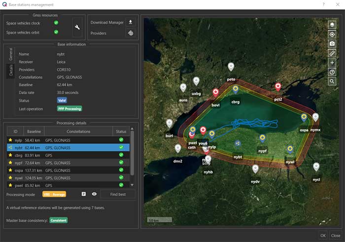
The virtual base station feature in SBG’s Qinertia computes a virtual network around a project in which position accuracy is maximized, homogeneous and robust, the company said. (Photo: SBG Systems)
SBG Systems has released a virtual base station (VBS) feature in Qinertia, its in-house GNSS and inertial navigation system (INS) post-processing software. According to the company, trajectory and orientation are greatly improved by processing inertial data and raw GNSS observables in forward and backward directions.
The VBS computes a virtual network around a project in which position accuracy is maximized, homogeneous and robust like a PPK short baseline, SBG said. Once surveyors collect data, Qinertia chooses the most relevant reference stations, builds a virtual network and brings the project to the centimetric accuracy with no jump on accuracy nor convergence effects, even in urban areas.
According to SBG, it has worked to offer a VBS which takes the most out of any GNSS receivers from different brands and models — with different configurations or constellations — and even with different coordinate systems. Qinertia automatically adjusts the VBS network to compensate for any base station position inaccuracy and provides full quality control indicators to assess the expected accuracy and reliability, the company added. Qinertia VBS technology can mix users base stations with permanent network base stations to improve accuracy in remote locations.
Finally, Qinertia automatically selects the best positioning technology that applies to a user’s project, whether it is a single base station mode, the virtual base stations mode or a precise point positioning computation. Despite this, users can still take control and make adjustments — like — while Qinertia automatically re-checks and re-computes all parameters simultaneously to validate the accuracy and consistency.
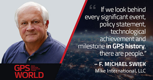
F. Michael Swiek, president, Mike International LLC
It is often said that “Behind every successful man there is a woman.” Likewise, if we look behind every significant event, policy statement, technological achievement and milestone in GPS history, there are people. They make the textbook chronologies of impressive progress both personal and human.
My own 30-year association with GPS has tracked closely with that of GPS World. Here are vignettes that sit most warmly in my “family snapshot album” of great moments in GPS.
In December 1994, the Civil GPS Service Interface Committee (CGSIC) held its first international meeting in Edinburgh, Scotland, hosted by the Northern Lighthouse Board (NLB). The small team of Americans attending the meeting were invited the following day to participate as the “International Team” in the annual NLB quiz competition held in a venerable pub. The competition is hotly contested each year among the NLB divisions, with the winning division commemorated with a brass medallion on a large wooden plaque kept for decades in NLB headquarters. To everyone’s chagrin, the Americans won. The good humor and boisterous camaraderie of that evening laid the foundation for close and candid dialogue between U.S. and European institutions on a wide variety of satellite navigation issues for years to come.
In 1996, Charlie Trimble was to introduce Vice President Al Gore in a ceremony at the White House to announce a Presidential Policy Statement on GPS. On the scheduled day, Charlie was unable to enter the White House, despite being vouched for by White House officials, because he was carrying no photo ID. White House security asked me if I had anything official with Charlie’s picture. They finally accepted a copy of the Trimble Navigation annual report, because in the words of one security officer, “I’ve heard of fake driver’s licenses, but not fake corporate annual reports.” Charlie was admitted.
On September 11, 2001, all of us attending CGSIC and ION in Salt Lake City sat stunned in our conference room watching the news reports from New York. Our meeting sessions were canceled, but we came from our hotel rooms because we needed to be together as friends in our shock and confusion, worrying about our families and friends and what the days ahead would be like. Anyone with a cell phone able to get a line out gladly shared it.
“I’ll only be a minute, just want to check with my family.”
“Talk as long as you want.”
In the mid-1990s in the ION exhibit hall, I was walking and talking with Charlie Trimble, Randy Hoffman (founder of Magellan Systems) and Gary Burrell (co-founder of Garmin), who were engaged in good-natured trash talking about each others’ companies, products and personalities. Glen Gibbons, founder of this esteemed publication, came across us, smiled, and said he was surprised to see such a congenial group of competitors. Charlie responded that in the marketplace they were competitors, but at ION they were all colleagues.
Glen added, “So, all friends!”
All three blurted, “Don’t go that far!” amid more laughs and grins.
The Japan GPS Council became one of the earliest and most influential industry groups in helping to guide the evolution and growth of GPS policy and industry, due to the personal passion of Hiroshi Nishiguchi. When meetings were held in Washington, Nishiguchi, other international representatives, industry and government officials would be guests in our home for convivial dinner chats. Nishiguchi became so comfortable, we considered him like family. He would leave a cardigan sweater in our coat closet between visits, and upon entering our house would remove his tie and suit jacket, go to the closet, and put on his sweater — like Mr. Rogers — before relaxing for the evening. He performed this ritual even when accompanying senior Japanese officials.
So, while technological milestones and policy commitments tell a great deal of the story of GPS, there are also the unique and cherished people, and the privilege it has been to know them as friends.
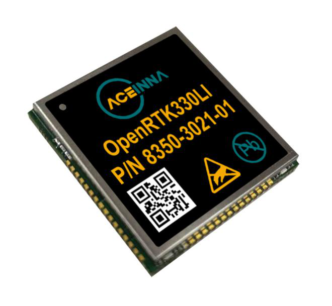
Aceinna, a developer of inertial-based guidance and navigation systems for autonomous vehicles and devices, has partnered with Point One Navigation, which delivers precise positioning for the next generation of transportation.
According to the companies, the partnership enables a streamlined positioning platform that combines Point One’s Polaris GNSS cloud correction service with Aceinna’s OpenRTK330 hardware and software solution for developers in agriculture, construction, mapping, surveying, robotics and trucking.
OpenRTK330, designed for use in Level 3 ADAS and other high-volume applications requiring precise position information, is a GNSS receiver with a built-in RTK engine and triple redundant inertial sensors. According to Aceinna, it includes a multi-band RTK/GNSS receiver coupled with redundant inertial sensor arrays to provide centimeter-level accuracy, enhanced reliability and superior performance during GNSS outages. OpenRTK300 is supported by Aceinna’s open-source tool chain.
Through backend server synchronization between the companies, activation and authentication will be streamlined. In addition, true centimeter-level accuracy will be attainable and powered by the integration of Point One’s coast-to-coast Polaris network and Aceinna’s OpenRTK platform, the companies said.
“This partnership between Aceinna and Point One harnesses and combines each of our distinct strengths, to offer a solution platform that makes high performance positioning accessible to a variety of industries and applications,” said Yang Zhao, chairman and CEO of Aceinna. “We are thrilled to work with Point One’s technical expertise and execution to advance this technology to the next level of precision.”
The combined offering will be available for purchase beginning December 2020.
Aceinna is headquartered in Andover, Massachusetts, and Point One Navigation is headquartered in San Francisco.
The global smart agriculture market size was valued at $16,747.7 million in 2019 and is estimated to reach $29,234.6 million by 2027, with a CAGR of 9.7% from 2021 to 2027, according to Valuates Reports.
The market is expected to rise as a result of rising population, increasing strain on the food supply system, the growing use of new technology in agricultural products and farmers’ growing focus on tracking livestock.
According to the report, the global competition between players will be increased by new players joining the global smart agriculture market, which will in turn increase advancements in technology. Top companies in the smart agriculture market include Trimble, Deere & Co., Topcon Positioning Systems, DeLaval, AgEagle Aerial Systems, Afimilk, Raven Industries, Ag Junction, AGCO Corporation and GEA Group, the report said.
Current trends influencing smart agriculture market size include the growing adoption of automation and control systems, such as GPS/GNSS receivers, irrigation controllers, and guidance and steering systems, has created a new approach to farming practices. The report said it also expects growing investment, R&D spending on agricultural technology and increased popularity of land-based recirculating aquaculture systems to fuel market growth.
The report also touched on COVID-19’s impact on the smart agriculture market, noting the market is expected to see a marginal fall in 2020 as movement restrictions and lockdowns have led to supply chain disruptions.
Despite this, the precision farming segment held the largest market share in 2019 and is expected to retain its dominance during the forecast period, the report said. North America is expected to hold the largest smart agriculture market share during the forecast period, and Asia Pacific is expected to witness the highest growth during the forecast period.
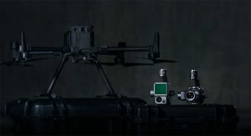
DJI unveiled two new solutions at Intergeo 2020: the DJI Zenmuse L1 lidar solution for aerial surveying and DJI Zenmuse P1 camera payload. (Photo: DJI)
DJI has debuted two payload solutions for its flagship commercial drone platform Matrice 300 RTK: the DJI Zenmuse L1 and DJI Zenmuse P1. The solutions were unveiled at Intergeo 2020.
DJI Zenmuse L1
The Zenmuse L1 is DJI’s first lidar solution for aerial surveying. DJI Zenmuse P1 integrates a Livox lidar module with a 70-degree FOV, a high-accuracy IMU, and a 20-megapixel camera with a 1-inch CMOS sensor and a mechanical shutter on a 3-axis stabilized gimbal.
According to DJI, the Zenmuse L1, which has a point rate of 240.000 points per second and a detection range of 450 meters, can generate true-color point cloud models in real-time, or acquire a vast area (up to 2 km2) of point cloud data in a single flight. The module supports both line scan mode and non-repetitive scanning mode.
When used with DJI’s flagship commercial drone platform Matrice 300 RTK and DJI Terra surveying software, it becomes a complete and versatile solution that gives the user real-time 3D data throughout the day, efficiently capturing the details of complex structures and delivering highly accurate reconstructed models, DJI said.
DJI Zenmuse P1
The DJI Zenmuse P1 camera payload integrates a 45-megapixel full-frame low-noise high-sensitivity sensor offering flexible viewing with interchangeable 24/35/50mm fixed-focus lenses on a 3-axis stabilized gimbal.
According to DJI, the Zenmuse P1 is equipped with a TimeSync 2.0 system, which synchronizes time across modules at the microsecond level. It features a smart oblique camera feature that helps improve efficiency by only capturing the photos essential to the reconstruction at the edge of the mapping areas. DJI Zenmuse P1 also integrates a 45-megapixel full-frame low-noise high-sensitivity sensor.
“With these two new payloads, we are providing an all-integrated complete solution to our enterprise customers active in accurate geospatial data acquisition,” said Arjun Menon, engineering manager at DJI in the U.S. “Having a fully integrated capable and affordable lidar seamlessly integrated into our best commercial drone is a dream that becomes reality for surveying, mapping and construction professionals. They will be able to see, cover and understand the geospatial context from a totally new perspective thanks to the high level of accuracy and quality of the data collected from these tools in the sky.”
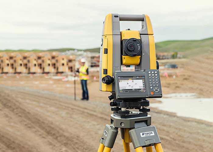
The new the GT series of total stations are part of a full workflow solution, including a new field computer, a full-version update to Topcon field and office software and GNSS receivers. The system is designed to work in sync for improved performance and better data handling with built-in, field-to-office connectivity.
The speed, tracking and accuracy of the GT series, combined with the intuitive software system, creates a flexible solution capable of satisfying the technology needs of surveyors and contractors performing survey, layout or machine guidance projects, Topcon said.
“The new total stations perform at a faster 10-Hz positioning update rate,” said Ray Kerwin, director of global product planning. “Combining the GT series with the new field computer and software enhancements, this tracking improvement makes layout easier and guidance more fluid, within an intuitive map view. More layout and survey points can be collected in less time.”
“Surveyors, contractors, as well as heavy machinery automation operators and other construction professionals can benefit from the time-savings and accuracy the series provides,” Kerwin said.
Advanced UltraTrac prism tracking combines optical sensing with a new ultrasonic motor control algorithm designed to maintain superior prism lock.
“Tracking fast-moving targets and maintaining prism lock is now easier on challenging job sites as well as in machine guidance applications. If you’re performing a machine control project where the prism is vibrating on the end of the blade, for instance, the GT will lock onto the prism better and provide smoother machine guidance,” Kerwin said.
Magnet software improves field-based quality reporting and data handling for larger files, graphical processing, and 3D models. Magnet Field features more visual- and map-based workflows in addition to menu-driven functionality popular with power users.
An optional upgrade incorporating hybrid positioning technology helps advanced users get instant location updates via GNSS receivers so positioning data points can be captured, even with the loss of line-of-sight from job site obstructions.
The complete GT series workflow solution — Magnet software, FC-6000 field computer, and HiPer Series GNSS receivers — combine for easy-to-use digital processes designed to help surveyors and contractors increase precision, reduce rework and improve quality control.