Author: Alan Cameron

  • The System: GPS Alliance, Galileo Budget, EGNOS Safe Skies

    New Organization Advocates for GPS Industry; Galileo Lives to Fly Another Day, Budget Passed; Safer Skies for EGNOS; and GLONASS in Brazil

    New Organization Advocates for GPS Industry

    A new group, the GPS Innovation Alliance, has formed and announced itself as the voice of the U.S. GPS industry and community of users, to “support the ever-increasing importance of GPS” in the U.S. capital, Washington, D.C.  The organization subsumes and replaces both the U.S. GPS Industry Council, an entity of longstanding, and the Coalition to Save Our GPS, which arose in March 2011 in response to a Federal Communications Commission (FCC) conditional waiver granted to LightSquared.

    The alliance appears to reflect a desire on the part of some industry members to take a more aggressive approach inside the Washington Beltway, a sign, it would seem, of the political times. Some of those involved spoke informally of a desire to take advantage of contacts made on Capitol Hill and in the media during the highly visible LightSquared combat, fought in the glare of media attention heretofore unknown in industry circles.

    GPSIA_logo
    GPSv Innovation Alliance logo

    Members of the Alliance are drawn from a variety of fields and businesses reliant on GPS, as well as leading manufacturers of GPS equipment. The former group includes, aviation, agriculture, construction, transportation, first responders, and surveying and mapping, and consumer organizations representing users of GPS for boating and other outdoor activities, and in automobiles, smartphones, and tablets.

    Joining John Deere, Garmin, and Trimble — three lead drivers of the Coalition effort at the FCC — are NovAtel Inc. and Topcon Positioning Systems. All five were previously long-time members of the USGIC, and they appear as founding members of the alliance at www.gpsalliance.org.

    Affiliate members listed on the website include the Association of Equipment Manufacturers, General Aviation Manufacturers Association, National Association of Manufacturers, Association for Unmanned Aerial Vehicles International, and Boat Owners Association of the United States.

    The alliance plans to build on “the proud heritage and extensive expertise of the United States GPS Industry Council (USGIC), which was formed in 1991 to promote broader commercial applications of GPS and to expand global markets while assisting in safeguarding the technology’s military advantages. The council has a long history of highly effective advocacy on behalf of the GPS industry, as well as serving as a trusted source of objective information for policy makers, the media and the public both in the U.S. and around the world.” The alliance website gives a longer statement about the history and record of the USGIC, highlighting its role in international negotiations.

    Michael Swiek, executive director of the USGIC, has transitioned to become the executive director, executive branch and international, of the Innovation Alliance. In addition to working closely with leading offices of executive branch departments of the U.S. government, he will continue well-established dialogs with governmental, private sector and academic entities in areas critical to GPS and satellite navigation among key players in Europe, Japan, Russia, Korea, China, and elsewhere.

    Heather Hennessey, a principal of Innovative Federal Strategies LLC, a “comprehensive government relations firm,” has taken the position of executive director, legislative, at the alliance. Hennessey has seven years of service in the House of Representatives, including two years as chief of staff for Congressman Jack Kingston of Georgia.

    An active voice in alliance representations on Capitol Hill will presumably be that of Jim Kirkland, vice president and general counsel for Trimble. Kirkland was the most prominent spokesperson for the coalition during the LightSquared battle, which appears to be either over or nearly so. “The alliance is committed to ensuring constructive, robust dialog between GPS users, manufacturers and policy makers on critical policy issues affecting GPS,” Kirkland said, “a commitment Trimble is pleased to be a part of as the industry continues to innovate and modernize.”

    The alliance mission statement cites the importance of GPS to global economy and infrastructure; vows to aid further GPS innovation, creativity and entrepreneurship; and to protect, promote and enhance the use of GPS.

    The GPS Innovation Alliance officially launched on February 13 with a reception on Capitol Hill, a traditional lobbying tactic that previous efforts had perhaps not envisioned.  The organization has also hired a public relations firm, Prism Public Affairs, and commissioned a logo.

    Galileo Lives to Fly Another Day, Budget Passed

    European Union leaders approved a scaled-down budget in early February, with none of the cuts to the Galileo program that had been widely feared. The project, conducted by the European Space Agency (ESA) under close supervision of the European Commission (EC),  will draw on funding of 6.3 billion euros (about $8.5 billion) from 2014 to 2020. The satellite navigation program held onto its requested revised budget of 6.3 billion euros, even as telecommunications research and broadband deployment projects, including another ESA pet project, the somewhat related Copernicus Global Monitoring for Environment and Security (GMES), underwent severe cuts. Galileo has already spent more than 3 billion euros ($4 billion), three times its original budget, to launch four of an envisioned 30-satellite constellation.

    The EU deliberative system requires unanimous approval of budget decisions, so what smaller countries seek for their farmers or fishermen carries practically equal weight to the desire of industrial/aerospace giants like Germany, closely followed by France and the United Kingdom. Negotiation is a delicate matter indeed, and reached an impasse in November 2012; resolution came only after a 24-hour marathon session of talks. The total budget represents the first decrease in the European Union’s history; austerity is the watchword in  a region beset with an ongoing bevy of international debt crises and serious recession in many of the smaller EU countries.

    Galileo supporters within the European Commission, the EU’s policy-making arm, continued to maintain that Galileo will “open a whole new world” for business to develop applications, as Antonio Tajani, EC vice president stated recently. The program drew strong support, for once, from powerful backers in the EU administrative capital, Brussels, and among industrial and political interests in key member states: France, Germany, and for an exception Britain, often a proponent of deep cuts.

    Negotiators helped Galileo’s chances by placing it in a research group labeled “Competitiveness for Growth and Jobs.” This category actually rose in budget allocation by nearly 40 percent over the last seven-year allotment.

    The allocation should cover operational costs for EGNOS and Galileo, the completion of the initial Galileo constellation of 14, and early procurement stages of a full, or second-generation orbiting set of 30.

    The program still faces an extremely unlikely date for the establishment of early services by the end of 2014. “Then, the market, as well as the governments of the Member States, will start increasing their interest and promoting further investments,” the ever-optimistic Tajani maintained.

    The budget must still secure approval by the European Parliament. Its president, Martin Schulz of Germany has stated, “The further we step away from the Commission’s proposed figures, the more likely the proposal will be rejected. More and more tasks, and less and less money — the inevitable result is budget deficits. The Parliament will not go along with this.”

    Parliament’s decision is forecast for the summer months. Parliament’s budget power consists of a direct yes-or-no vote to accept or reject the budget. The body cannot make modifications, and if rejecting would simply send it back to the EU ministers to begin all over again.  The picture is further complicated somewhat by the 20-nation make-up of ESA, whereas the European Union and its executive commission have 27 national members.

    Safer Skies for EGNOS

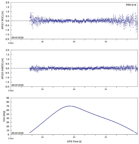
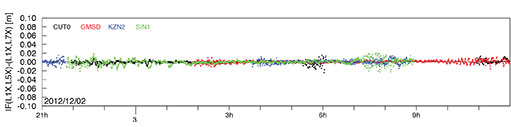
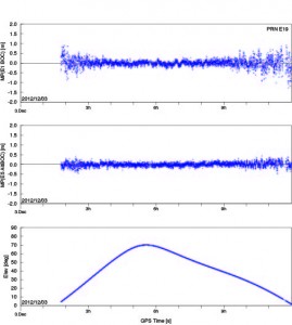
    Results of a September 2012 flight test in the Galileo Test and Development Environment (GATE) near Berchtesgaden, Germany, the one place on Earth where Galileo services are already routinely available, show that adding Galileo signals to the European Geostationary Navigation Overlay Service (EGNOS) should boost accuracy significantly. EGNOS augments the accuracy and reliability of GPS signals over Europe, rendering satnav usable for safety-critical applications such as aircraft guidance, as well as more general precision uses.

    Operational horizontal and vertical distance “protection levels” for safety were cut by half by combining use of GPS and Galileo within EGNOS. In addition, new integrity algorithms installed within the user receiver turned out to reliably detect and exclude reflected or otherwise faulty signals.

    Next-generation EGNOS, planned for 2020, is envisaged to augment both constellations and dual frequencies at the same time, making the system much more robust.

    GLONASS in Brazil

    The first overseas GLONASS ground monitoring station for differential correction and monitoring outside Russian territory opened in Brasilia, Brazil, in mid-February. The station represents an early step in an initiative to modernize and significantly improve the accuracy of GLONASS signals.

    Plans call for similar monitoring stations “in more than 30 countries of the world. Most of the countries that received the offers for the installation of the stations responded positively.However, the process is slow because of the need to conclude appropriate intergovernmental agreements. The documents with Brazil were signed in 2012. Agreements with Spain, Indonesia and Australia will be finalized soon,” according to a Pravda story.

  • Out in Front: The Semi-Private Life of Waldorf Twitty

    We’re going through!” The Captain’s voice was like thin slate breaking. He wore combat fatigues with a dusty beret.

    “We can’t make it, sir. They’re laying down fire too heavy, if you ask me.”

    “I’m not asking you, lieutenant,” said the Captain. “Go to overdrive!”

    The throb of the diesel Stryker increased: cha-rugga-rugga-rugga. He surveyed the rocky defile ahead. “Throw back the shield!” he shouted. “Swing out the M240!”

    The crew, bending to tasks in the rocking transport, grinned. “The Old Man’ll bring us through,” they said. “The Old Man ain’t afraid of hell!” . . .

    “Get a free muffin with your next mocha latte!” Waldorf Twitty’s phone on the passenger seat squawked.

    “Hmm?” said Twitty. He regarded the smartphone in mild astonishment. “You’re within 15 meters of Studbricks. Bring your e-coupon now!” Waldorf Twitty drove on in silence, the fire of the worst ambush in years of guerilla warfare fading in the airways of his mind. “Recalculating!” yapped the phone urgently. “Head for Studbricks!”

    Waldorf Twitty proceeded to a parking lot at town’s edge. He hefted his laptop, pocketed his phone, and crossed the green expanse of industrial campus toward a distant office block, passing a clinic that ministered to employees.

    . . . “It’s the billionaire investor, Boren Wellfleet,” said the pretty nurse.

    Waldorf Twitty put down his external hard drive, repository of his own medical research. “Who has the case?”

    “Dr. Debakow, and a specialist, Dr. Farnyard, has flown in.”

    A door opened and Farnyard emerged, distraught. “It looks bad for Wellfleet. Obstreosis of the ductal tract. Tertiary. Wish you’d take a look.”

    “Glad to,” said Twitty.

    In the operating room Dr. Debakow whispered, “I’ve read your blog on streptothricosis — brilliant.” At this moment a machine with many displays began to go rugga-rugga-rugga.

    “The new anaesthetizer is giving way!” cried an intern. “No one knows how to fix it!”

    Twitty glided to the machine, now going rugga-rugga-queep-rugga-rugga-queep. “Give me a USB drive!” he snapped. He inserted the device in his own hard drive, then into a port on the trembling, moaning anaesthetizer. “That will hold for ten minutes,” he said. “Get on with the operation.”

    “Coreopsis has set in,” said Farnyard nervously. “Would you take over, Twitty?”

    “If you wish.” . . .

    “I see you! You’re in the geofence!” his boss’s voice barked. Waldorf Twitty halted and looked around; people passed tranquilly to and fro. “I’m tracking your phone now — why aren’t you here yet? Where’s the Veeblefreetzer design!?! Why weren’t you in at 6 this morning?”

    Twitty groaned. He had never figured out how to disable the location transmit function on his phone. Every app he downloaded — and he had many — claimed location-sharing could be turned off, but they buried the settings so deep. He turned back to the parking lot. He would call in sick. Or something.

    . . .The dark-haired beauty took his hand. “You’ll lead us out of here?” she quavered. He nodded grimly. . .

    “Say, bud, looks like you’re under-insured!” a friendly voice boomed from his pocket. “Bill Lacky with Consolidated Coverage, friend of your friend’s friend on Facebook, and a 3rd removed on LinkedIn. I’m just a few blocks away. I bet I can get an introduction from someone by the time I’m there. Heading your way!”

    At a corner he leaned against a wall in the shade. “This is the police, Mr. Twitty. We are authorized to make an employer’s arrest. Hold your phone and stand perfectly still. An officer has your coordinates and will arrive shortly.”

    . . . He put his shoulders back and his heels together. “To hell with the blindfold,” said Waldorf Twitty. Then, with that faint, fleeting smile on his lips, he faced the firing squad: erect, motionless, proud and disdainful. Waldorf Twitty, inscrutable to the last.


    [with apologies to James Thurber.]

  • New Organization Advocates for GPS Industry

    A new group, the GPS Innovation Alliance, has formed and announced itself as the voice of the U.S. GPS industry and community of users, to “support the ever-increasing importance of GPS” in the U.S. capital, Washington, D.C.  The organization subsumes and replaces both the U.S. GPS Industry Council, an entity of longstanding, and the Coalition to Save Our GPS, which arose in March 2011 in response to a Federal Communications Commission (FCC) conditional waiver granted to LightSquared.

    The alliance appears to reflect a desire on the part of some industry members to take a more aggressive approach inside the Washington Beltway, a sign, it would seem, of the political times. Some of those involved spoke informally of a desire to take advantage of contacts made on Capitol Hill and in the media during the highly visible LightSquared combat, fought in the glare of media attention heretofore unknown in industry circles.

    Members of the Alliance are drawn from a variety of fields and businesses reliant on GPS, as well as leading manufacturers of GPS equipment. The former group includes, aviation, agriculture, construction, transportation, first responders, and surveying and mapping, and consumer organizations representing users of GPS for boating and other outdoor activities, and in automobiles, smartphones, and tablets.

    Joining John Deere, Garmin, and Trimble — three lead drivers of the Coalition effort at the FCC — are NovAtel Inc. and Topcon Positioning Systems. All five were previously long-time members of the USGIC, and they appear as founding members of the alliance at www.gpsalliance.org.

    Affiliate members listed on the website include the Association of Equipment Manufacturers, General Aviation Manufacturers Association, National Association of Manufacturers, Association for Unmanned Aerial Vehicles International, and Boat Owners Association of the United States.

    The alliance plans to build on “the proud heritage and extensive expertise of the United States GPS Industry Council (USGIC), which was formed in 1991 to promote broader commercial applications of GPS and to expand global markets while assisting in safeguarding the technology’s military advantages. The council has a long history of highly effective advocacy on behalf of the GPS industry, as well as serving as a trusted source of objective information for policy makers, the media and the public both in the U.S. and around the world.” The alliance website gives a longer statement about the history and record of the USGIC, highlighting its role in international negotiations.

    Michael Swiek, executive director of the USGIC, has transitioned to become the executive director, executive branch and international, of the Innovation Alliance. In addition to working closely with leading offices of executive branch departments of the U.S. government, he will continue well-established dialogs with governmental, private sector and academic entities in areas critical to GPS and satellite navigation among key players in Europe, Japan, Russia, Korea, China, and elsewhere.

    Heather Hennessey, a principal of Innovative Federal Strategies LLC, a “comprehensive government relations firm,” has taken the position of executive director, legislative, at the alliance. Hennessey has seven years of service in the House of Representatives, including two years as chief of staff for Congressman Jack Kingston of Georgia.

    An active voice in alliance representations on Capitol Hill will presumably be that of Jim Kirkland, vice president and general counsel for Trimble. Kirkland was the most prominent spokesperson for the coalition during the LightSquared battle, which appears to be either over or nearly so. “The alliance is committed to ensuring constructive, robust dialog between GPS users, manufacturers and policy makers on critical policy issues affecting GPS,” Kirkland said, “a commitment Trimble is pleased to be a part of as the industry continues to innovate and modernize.”

    The alliance mission statement cites the importance of GPS to global economy and infrastructure; vows to aid further GPS innovation, creativity and entrepreneurship; and to protect, promote and enhance the use of GPS.

    The GPS Innovation Alliance officially launched on February 13 with a reception on Capitol Hill, a traditional lobbying tactic that previous efforts had perhaps not envisioned.  The organization has also hired a public relations firm, Prism Public Affairs, and commissioned a logo.

  • Galileo Lives to Fly Another Day; Budget Passed

    European Union leaders approved a scaled-down budget in early February, with none of the cuts to the Galileo program that had been widely feared. The project, conducted by the European Space Agency (ESA) under close supervision of the European Commission (EC),  will draw on funding of 6.3 billion euros (about $8.5 billion) from 2014 to 2020. The satellite navigation program held onto its requested revised budget of 6.3 billion euros, even as telecommunications research and broadband deployment projects, including another ESA pet project, the somewhat related Copernicus Global Monitoring for Environment and Security (GMES), underwent severe cuts. Galileo has already spent more than 3 billion euros ($4 billion), three times its original budget, to launch four of an envisioned 30-satellite constellation.

    The EU deliberative system requires unanimous approval of budget decisions, so what smaller countries seek for their farmers or fishermen carries practically equal weight to the desire of industrial/aerospace giants like Germany, closely followed by France and the United Kingdom. Negotiation is a delicate matter indeed, and reached an impasse in November 2012; resolution came only after a 24-hour marathon session of talks. The total budget represents the first decrease in the European Union’s history; austerity is the watchword in  a region beset with an ongoing bevy of international debt crises and serious recession in many of the smaller EU countries.

    Galileo supporters within the European Commission, the EU’s policy-making arm, continued to maintain that Galileo will “open a whole new world” for business to develop applications, as Antonio Tajani, EC vice president stated recently. The program drew strong support, for once, from powerful backers in the EU administrative capital, Brussels, and among industrial and political interests in key member states: France, Germany, and for an exception Britain, often a proponent of deep cuts.

    Negotiators helped Galileo’s chances by placing it in a research group labeled “Competitiveness for Growth and Jobs.” This category actually rose in budget allocation by nearly 40 percent over the last seven-year allotment.

    The allocation should cover operational costs for EGNOS and Galileo, the completion of the initial Galileo constellation of 14, and early procurement stages of a full, or second-generation orbiting set of 30.

    The program still faces an extremely unlikely date for the establishment of early services by the end of 2014. “Then, the market, as well as the governments of the Member States, will start increasing their interest and promoting further investments,” the ever-optimistic Tajani maintained.

    The budget must still secure approval by the European Parliament. Its president, Martin Schulz of Germany has stated, “The further we step away from the Commission’s proposed figures, the more likely the proposal will be rejected. More and more tasks, and less and less money — the inevitable result is budget deficits. The Parliament will not go along with this.”

    Parliament’s decision is forecast for the summer months. Parliament’s budget power consists of a direct yes-or-no vote to accept or reject the budget. The body cannot make modifications, and if rejecting would simply send it back to the EU ministers to begin all over again.  The picture is further complicated somewhat by the 20-nation make-up of ESA, whereas the European Union and its executive commission have 27 national members.

  • GPS Market Report Forecasts Growth, but Not Comprehensive

    TechNavio’s analysts forecast the GPS market to grow at a CAGR of 25.8 percent over the period 2011-2015, stated in a press release for a recent report, “The Global Positioning System Market 2011-2015.” The company declined to provide any details of substance to back this claim.

    The company’s press release states that “Key vendors dominating this market space include Garmin Ltd., MiTAC International Corp. and TomTom International BV.” This leaves out several key manufacturers of low-cost, low-precision GPS chips and devices, including the large suppliers into the smartphone market. It evidently makes no attempt to include the high-precision segment. Thus it is unlikely that the report presents a complete picture of the market, and its accuracy is also open to conjecture.

    The press release goes on to say that “Other vendors mentioned in this report include Trimble Navigation Ltd. and DeLorme,” but does not say in what context or to what depth these two, among many others that could have been included, are “mentioned.”

  • Report from ION ITM: Faster, Smaller, Cheaper

    And more of them!

    That’s been one of the mantras — a controversial one, granted — of technological advance in the late 20th and early 21st centuries. It has succeeded in penetrating the global positioning, navigation, and timing vanguard, as evidenced by a handful of key presentations on the first day of the Institute of Navigation (ION) International Technical Meeting in San Diego on Monday.

    Skybox Imaging, a company that is “passionate about bringing Moore’s Law to space via disruptive microsatellite technology, rapid development cycles, and a scalable web-based delivery platform,” spoke to the ION ITM plenary session in the person of Ronny Votel, an engineer leading the company’s guidance, navigation and control division. Skybox’s goal is to provide “easy access to reliable and frequent high-resolution images . . . through a “constellation of imaging microsatellites delivering high-resolution imagery of any spot on Earth multiple times per day.”

    To achieve that goal, Skybox is developing a low-cost imaging satellite system:

    • design life of the satellites, 3 years;
    • size of the satellites, a mini-fridge;
    • size of the constellation, in the tens.

    Skybox will pair that flying system with web-accessible big data processing platform to capture video or images of any location on Earth within a couple of days — an unheard of delivery turnaround in the current global imaging industry, unless you happen to be a government (as in central, high, federal, perhaps military) customer.

    The low-cost nature of the satellite opens the possibility of deploying tens of satellites which, when integrated together, have the potential to image any spot on Earth within an hour. Votel several times made the analogy in his talk of using an iPhone camera to capture desired imagery, and indeed that could be a next logical step in FBC development: just throw a bunch of camera phones up into orbit.

    Skybox expects to launch its first two satellites later this year.

    In April of last year, Wired published a fascinating history and analysis: “Smaller, Quicker, Secret, Robotic: Inside America’s New Space Force.” Between Between 1992 and 1999, the U.S. National Aeronautics and Space Administration (NASA) launched 16 faster, smaller, cheaper missions, including Mars probes and space telescopes. Ten missions succeeded; six failed. Analysts declared the initiative a failure, and to a large extent it has been forsaken. Recent public writings, though, show second thinking. “I would like to respectfully suggest that success-per-dollar is a more meaningful measurement of achievement than success per-attempt,” stated one Air Force lieutenant colonel in a treatise on program management lessons from NASA.

    Could such an approach work for GNSS satellites, some of which are burdened with extraneous non-PNT payloads that make them far from FSC? Time will tell the wiser.

    Microtechnology

    In that FSC vein, at one of the afternoon’s technical sessions, Andrei Shkel of UC-Irvine had been scheduled to deliver a paper on “Precision Navigation and Timing Enabled by Microtechnology,” but apparently something came up and he was not able to appear. I had looked forward very much to what I anticipated would be an update to his September 2011 article in GPS World, “Microtechnology Comes of Age,” which was itself an update to a plenary talk he gave at ION ITM back in 2011. For now, that article will have satisfy us.

    Other presentations in the same MEMS, atomic clock, and MicroPNT session:

    Michael Bulatowicz of Northrop Grumman talked about a DARPA-backed project, the nuclear magnetic resonance (NMR) gyroscope. Northrop’s development and research has shown a viable solution to producing a small (size of a U.S. quarter coin) low-power navigation grade gyro using non-vibratory technology. The company has produced two prototypes and is at work on two more. Feed the NMR gyro into Shkel’s work and who knows what you’ll get in terms of FBC PNT? Well, maybe not cheaper in the immediate future. Bulatowicz said that as an assembled device he expected its cost, at least initially, to be substantially higher than MEMS technology.

    Richard Waters of Lumedyne Technologies spoke on next-generation MEMS inertial sensors with white-noise characteristics, a new paradigm based on time-domain switching for how MEMS sensors might work. TDS inertial sensors provide some key benefits: a purely digital approach, recalibration due to bias drift is not required, output is independent of oscillator conditions. Power is low, less than 1 millwatt. The device demonstrated switch stability under static conditions to –170 db. The same TDS concept can also be applied to a mechanical gyro.

    QZSS

    In other ION ITM first-day news, H. Tokura of the Tokyo University of Marine Science and Technology talked about “The Possibility of Precise Automobile Navigatin using GPS/QZS and Galileo E5 Pseudoranges.” Currently, research and prototype automobile high-precision PNT is done with real-time kinematic (RTK) networks, but this has some disadvantages, as discussed in an article by authors from the University of Nottingham, UK, in the February issue of GPS World.

    Japan’s QZSS now broadcasts L5 signals. Japan has essentially leapfrogged the United States, since the L5 signals with full CNAV message is already broadcast by satellite QZSS-1. Currently, three U.S. GPS satellites are L5 CNAV-capable, but none are broadcasting such a signal.

    Tokura showed results demonstrating that pseudorange observables from L5 are basically robust enough for this task. Further investigation for L5 is required because manufacturers are still developing the tracing technique for the new L5 signal. A software-defined receiver is indicated for usage.

    Hideki Yamada of Japan’s Electronic Navigation Research Institute spoke about the possibility of using only the QZSS constellation, “in case of GPS failure,” for RTK positioning in precision ag and machine control, with 4 to 7 QZSS satellites that could be launched in a future version of the constellation. QZSS has been shown to provide 10-meter accuracy in absence of GPS; now the research looks at an RTK method.

    With only one satellite in orbit, RTK-QZSS cannot be tested in the field. The researchers simulated a fuller constellation by using QZS-1, Multifunctional Transport Satellites (MTSAT), a set of geostationary weather and aviation control satellites, and GPS signals. Using a JAVAD Alpha receiver, Trimble and NovAtel antennas, they obtained results with low multipath error (about 30 centimeters) in a Tokyo environment. Multi-epoch processing is necessary for RTK-QZSS. This solution can work well as a minimum backup system of high-precision position under relatively moderate DOP condition.

    __________________

    Living may be easy, dying may be hard. But I’m wide awake, staying up late, sending my regards.

  • The System: Galileo IOV-3, Russian SBAS, Road Tolling

    Galileo IOV-3 Broadcasts E1, E5, E6 Signals; Russian SBAS Luch-5B in Orbital Slot; EGNOS and Galileo in Emergency Call, Road Tolling; Compass ICD Rumored

    Galileo IOV-3 Broadcasts E1, E5, E6 Signals

     By Oliver Montenbruck, German Space Operations Center and Richard B. Langley, University of New Brunswick

    After reaching its final position, the Galileo IOV-3 satellite started transmitting its first ranging signals on December 1. Within three days, the various carriers (E1, E5, E6) and associated modulations were activated, and full in-orbit testing is now in progress. Anyone with commonly available GNSS receivers can presently access the open signals in the E1, E5a, and E5b frequency bands as well as the wide-band E5 AltBOC signal.

    According to statements made at the recent 6th ESA Workshop on Satellite Navigation Technologies (Navitec 2012) in Noordwijk, The Netherlands, the IOV-3 satellite, which is also identified as Flight Model 3 (FM3) and E19 after its pseudorandom noise code, will continue to use binary offset carrier modulation — specifically BOC(1,1) — on the E1 Open Service signals for the time being. In contrast to this, the first pair of IOV satellites has already started to use composite binary offset carrier modulation, which offers better multipath suppression in the received signal.

    Right after its activation, IOV-3 could be tracked immediately by the global network of stations participating in the Multi-GNSS Experiment (MGEX; http://www.igs.org/mgex) initiated by the International GNSS Service (IGS).

    Fig1 Source: Oliver Montenbruck, German Space Operations Center and Richard B. Langley, University of New Brunswick
    Figure 1. Pseudorange errors of IOV-3 tracking at Tanegashima, Japan, using the E1 BOC(1,1) signal (top) and the E5 AltBOC signal (center). The elevation angle over time is shown in the bottom panel.

    The high quality of the IOV-3 signals is illustrated by measurements collected by the Tanegashima station during a 10-hour pass of the satellite over Japan (see Figure 1). The E5 AltBOC pseudorange measurements in particular exhibit an exceptionally low noise and multipath level of better than 10 centimeters at mid- and high-elevation angles.

    An attractive feature of the Galileo system is the availability of multiple signal frequencies, which opens up numerous prospects for precise positioning and scientific investigations.

    Carrier-Phase Measurements

    While the E6 signals foreseen for a future Commercial Service are not presently supported by geodetic receivers due to the lack of information on the transmitted codes and possible licensing issues, users can already benefit from the E5a and E5b signals in addition to E1. By way of example, the ionosphere-free and geometry-free linear combination can be formed from carrier-phase measurements on these frequencies. Results of some first tests using this combination for IOV-3 are shown in Figure 2, based on measurements made at four MGEX stations: CUT0 (Perth, Australia), GMSD (Tanegashima, Japan), KZN2 (Kazan, Russia), and SIN1 (Singapore).

    The results provide an indication of carrier-phase noise and multipath effects but are free of long-term variations that have earlier been found in GPS L1/L2/L5 signal combinations.

    It is anticipated that similar measurement quality will be obtained with the E1 and E5 signals of IOV-4, which were activated on December 12 and 13.
    This level of performance highlights the potential benefit of Galileo signals in advanced triple-frequency techniques such as undifferenced ambiguity resolution and ionospheric monitoring.

    Figure 2 The difference between the ionosphere-free carrier-phase combinations formed from E1/E5a and E1/E5b signals received at four MGEX stations: CUT0 (Perth, Australia), GMSD (Tanegashima, Japan), KZN2 (Kazan, Russia), and SIN1 (Singapore). Source: Oliver Montenbruck, German Space Operations Center and Richard B. Langley, University of New Brunswick
    Figure 2 The difference between the ionosphere-free carrier-phase combinations formed from E1/E5a and E1/E5b signals received at four MGEX stations: CUT0 (Perth, Australia), GMSD (Tanegashima, Japan), KZN2 (Kazan, Russia), and SIN1 (Singapore).

    Russian SBAS Luch-5B in Orbital Slot

    The second Russian satellite-based augmentation system (SBAS) satellite, Luch-5B, has now been positioned at its designated orbital slot of 16 degrees west longitude. The satellite had been in a drift orbit since its launch on November 2 at 21:04:00 UTC along with the domestic communications satellite Yamal-300K.

    NORAD/JSpOC tracking data showed Luch-5B arriving at its geostationary position by about December 13. Figure 3 shows the footprint of the satellite with the elevation-angle contours at 30-degree intervals.
    Luch-5B, the second of a set of three geostationary satellites being  launched to reactivate Roscosmos’s Luch Multifunctional Space Relay System, is expected to use PRN code 125.

    The Luch system will relay communications and telemetry between low-Earth-orbiting spacecraft, such as the the Russian segment of International Space Station, and Russian ground facilities. The system’s satellites also carry transponders for the System for Differential Correction and Monitoring (SDCM), Russia’s SBAS. The transponders will broadcast GNSS corrections on the standard GPS L1 frequency.

    Luch-5A, launched in December 2011, resides in an orbital slot at 95 degrees east longitude. It began transmitting corrections on July 12, 2012 using PRN code 140.

    Figure 3 Geostationary position of Luch-5B, carrying a transponder for the Russian System for Differential Correction and Monitoring. Source: Oliver Montenbruck, German Space Operations Center and Richard B. Langley, University of New Brunswick
    Figure 3. Geostationary position of Luch-5B, carrying a transponder for the Russian System for Differential Correction and Monitoring.

    EGNOS and Galileo in Emergency Call, Road Tolling

    The Intelligent Transport Systems (ITS) World Congress in Vienna this fall drew attention to the multi-constellation advantages provided by Galileo during a session on eCall, the European initiative for safer mobility. “Galileo will provide accuracy and reliability in all the transport markets, but in the case of emergency rapid assistance, the positioning need is even more critical,” said Fiammetta Diani, market development officer at the European GNSS Agency (GSA).

    A multiconstellation approach for eCall and similar initiatives will deliver better performance without additional costs. Yaroslav Domaratsky from NIS-GLONASS, the Russian national navigation services provider, confirmed that ERA-GLONASS, the Russian version of eCall, will benefit from multiconstellation. “Solutions including also Galileo are welcome in the Russian initiative.”

    Satellite ITS applications in road transport cover much more than in-car navigation. They include road-user charging with satellite-based toll collection systems; in-vehicle dynamic route guidance for drivers; intelligent speed adaptation to control the speed of vehicles externally; traveller information systems; and fleet-tracking systems for better management of freight movements and goods delivery.

     its_t3_476 Source: Oliver Montenbruck, German Space Operations Center and Richard B. Langley, University of New Brunswick

    Road Tolling

    European road-toll operators outlined how they plan to emply the European Geostationary Navigation Overlay Service (EGNOS) and Galileo to provide new tolling solutions.

    Luigi Giacalone, managing director of Autostrade Tech, which provides the technology for the French Ecomouv project, said EGNOS will contribute to reliably collect taxes on the heavy trucks using the road charging scheme. “This is a tax, not a toll. It aims to collect a new tax reliably and fairly according to distance travelled, while dissuading fraud,” he said. “Thanks to GNSS multi-constellation, only 10 locations out of the 15,000-kilometer network need support beacons.”

    Ecomouv, which Includes anti-jamming and anti-spoofing mechanisms, covers 600,000 French lorries and 200,000 foreign ones, and will run from July 2013 for 11.5 years. Giacalone said its performance target was 99.75 percent accuracy of the entire collection chain, and its trials had already 99.8 percent accuracy.

    Miroslav Bobošík from SkyToll, which operates Slovakia’s electronic tolling operations, explained how the system was able to cover not only 570 kilometers of motorways, but also 1,800 kilometers of first class roads in the country. “We needed a flexible system to cover different roads in different circumstances. And also to be fair to drivers, so they pay only for what they use,” said Bobošík. “We cover all services, not just toll collection, but enforcement, and technological maintenance and repair.”

    GNSS tolling means flexibility as well as feasibility for SkyToll: since  its launch in mid-2010, many changes have been made to the operation of the network, but thanks to the technology, they were easy to make. And they were cheap, he said. “While it is difficult to compare costs with other country, SkyToll has the lowest cost per kilometer to operate,” he said. “GNSS is the best possible solution for electronic tolling system in Slovakia, and GNSS is the most suitable for ITS.”

    Changing the Game

    Volker Vierroth from T-Systems, the German IT services subsidiary of Deutsche Telekom, explained GNSS’s game-changing role: the availability of a huge variety of additional data linked to actual positions; more computing power, notably mobile and cloud-based; fast and reliable networks available now with broad coverage, most recently with the shift from 3G to 4G; and smartphones, powerful and versatile, surging to the fore.

    “GNSS [in the form of EGNOS] has proved to be a reliable technology for large-scale road charging on complex networks,” he said. “Galileo will bring further improvements, and may become the cornerstone of future road applications.”

    Compass ICD Rumored

    As this magazine goes to press, unconfirmed reports from Shanghai state that the Compass Interface Control Document (ICD) will be released on December 27.

    Such rumors surfaced in late 2010 and again in late 2011. An October 2011 GPS World newsletter reported “The long-awaited signal ICD for China’s growing GNSS will appear this month, according to representatives of the system who spoke in a “Compass: Progress, Status, and Future Outlook” workshop in September [2011].

    “The ICD has been rumored to be available previously to receiver manufacturers within China, creating some disgruntlement among companies outside the country. A workshop panelist affirmed that GPS/Compass chips and receivers are being actively developed by many Chinese manufacturers and research institutes.”


  • Out in Front: Let the Chips Fall

    We either continue to totter at the brink of a global financial precipice, or we sit crumpled on the canyon floor far below, peering skyward, wondering what might have been, and resolving to pick up what pieces we can and carry on.

    It is impossible to tell as this magazine goes to press in December just where we may find ourselves, and in what shape, come the early days of January 2013. Those elected parties with responsibility for the state of our fiscal affairs, who in the best of all possible worlds would  possess some sort of vision for the future, continue to posture, prevaricate, pander, and generally excuse themselves from worrying about what may happen to the rest of us. After all, they will still be in office and drawing good salaries come the New Year, come what may.

    The GNSS industry has pulled through the last half-decade of worldwide recession as well as most, better than many. There have been some casualties along the way, and almost universal belt-tightening. But we keep moving onward and upward, blessed with a technology that continues to find new and profit-bearing applications, and encouraged by researchers further out in front of us, who discover and develop yet newer possibilities at an astonishing rate.

    Now we face new uncertainty. The domino-paths of the global economy wend this way and that, curving, intertwining, doubling back, snaking everywhere. A toppled piece here can lead to a cascaded pile-up way over on the other side of the board, and vice versa.

    It all comes down to end-user ability to buy, to upgrade, to invest in the future — as opposed to holding tight to whatever can be preserved in the present.
    If characterizing GNSS end-users could be done by naming off surveyors, farmers, fishermen, and other outdoor enthusiasts, then determining the economic outlook for this industry would be easier to do, though the picture might not necessarily be any more optimistic. But the GNSS end-user community has swelled almost immeasurably to include the automotive industry, the telecommunications industry (in both its infrastructure and its own end-user equipment), utilities, airlines and the aircraft industry, militaries around the world, and even governments themselves — municipal, state, and national. Every one of these entities has a budget and acutely feels the chills — and in more delayed fashion, the warnings — of national and global economies.

    Should the United States Congress, in full possession of all its political wisdom, drive the country over the fiscal precipice, reverberations of the crash in the chasm below will propagate far and wide — and into the very marrow of our bones.

    We have overcome before. With science and technology as our co-pilots (or are they our engines?), we shall overcome again. We may and should speak out, attempting to influence the political process, but we cannot control its outcomes.

    We can do our own jobs, and we will.  Accept change, keep calm, carry on.

  • Galileo and Compass: A Tale of Also-Runnings

    Beating up the backstretch neck and neck, tied for third in the GNSS race, Galileo and Compass today offer some signals and some satellites to GNSS users — as long as those users are researchers. Galileo has more going for it in the way of signals, while Compass holds an edge in the number of satellites. Without an interface control document (ICD) to guide user/researchers and most importantly manufacturers in the employment of its signals, Compass satellites, however they may increase, are practically useless to anyone outside China. A Compass ICD has been rumored before and is now rumored again. Wait and see before placing your bets.

    The fourth Galileo in-orbit validation (IOV) satellite, Flight Model 4 (FM4), began transmitting signals on December 12, joining its co-launched confrère FM3, which began airing navigation signals on December 1. The FM4 spacecraft uses PRN code E20. As of this writing, FM3 is broadcasting E1, E5, and E6 signals, and FM4 is  broadcasting E1 and E5 signals; we don’t know if and when FM4 E6 signals start(ed) until ESA tells us.

    GPS World authors Oliver Montenbruck (German Space Operations Center) and Richard Langley (University of New Brunswick) have written an early analysis of the signals from FM3; this account will appear in the January issue of the magazine. A few selected excerpts from that article, and one figure:

    “Anyone with commonly available GNSS receivers can presently access the open signals in the E1, E5a, and E5b frequency bands as well as the wide-band E5 AltBOC signal.

    Source: GPS
    Figure 1: Pseudorange errors of IOV-3 tracking at Tanegashima, Japan, using the E1 BOC(1,1) signal (top) and the E5 AltBOC signal (center). The elevation angle over time is shown in the bottom panel.

    “According to an ESA statement, FM3will continue to use binary offset carrier modulation — specifically BOC(1,1) — on the E1 Open Service signals for the time being. In contrast to this, the first pair of IOV satellites has already started to use composite binary offset carrier modulation, which offers better multipath suppression in the received signal.

    “The E5 AltBOC pseudorange measurements in particular exhibit an exceptionally low noise and multipath level of better than 10 centimeters at mid- and high-elevation angles.”

    After discussing and displaying some carrier-phase measurements of the Galileo FM3 E1, E5, and E6 signals, Montenbruck and Langley conclude; “This level of performance highlights the potential benefit of Galileo signals in advanced triple-frequency techniques such as undifferenced ambiguity resolution and ionospheric monitoring.”

    Theoretically, the total of four Galileo IOV satellites now in medium-Earth orbit yield the minimum number needed to perform a 3D navigation fix, although no statement of initial — or even sketchy — operating capability has been issued by the European Space Agency (ESA), nor is one expected.

    Antonio Tajani, vice-president of the European Commission (EC) and head of the EC directorate-general responsible for industry and entrepreneurship, continues to publicly maintain a “political objective [of] the delivery of the first services before the end of 2014,” based on 18 orbiting satellites. In a December speech, he revised the basis for that position slightly to say the civil Open Service (OS) could be declared operational with as few as 12 satellites.

    The system operators had announced three dual-satellite launches in 2013, two dual-satellite launches and one four-satellite launch in 2014, hypothetically producing an operable constellation of 18 satellites by the end of the promised 2014. However, unconfirmed reports from Europe suggest that problems with manufacture of the next set of 14 Galileo satellites mean that no launches at all will take place until Q4 of 2013. Whether this will push out the service delivery date beyond 2014 or not remains open to conjecture.

    Compass

    Another matter open to conjecture and much speculation is whether the world will soon — or ever — see an interface control document (ICD) for China’s Compass system.  More than a year ago, I wrote that “The ICD has been rumored to be available previously to receiver manufacturers within China, creating some disgruntlement among companies outside the country . . .  GPS/Compass chips and receivers are being actively developed by many Chinese manufacturers and research institutes.”  Indeed, conference presentations, leading to a published article in this magazine’s October issue, “What Is Achievable with the Current Compass Constellation,“ confirm that this is so.

    And yet, the rest of the world neither has nor holds a Compass ICD.

    The end-of-year rumor mill has kicked into gear again, though. A GNSS industry representative stationed in Shanghai, China sent this message recently to a U.S. colleague: “Latest unofficial news said that the Compass Interface Control Document (ICD) will be released on 27th this month, and will be available on the internet on 28th.”

    We shall see what we shall see.

  • Avenza Releases MAPublisher 9.1 for Adobe Illustrator

    New ability to export HTML5 web maps and enhanced MAPublisher LabelPro features.

    Avenza Systems Inc., producers of the PDF Maps app for iOS and geospatial plugins for Adobe Creative Suite, including Geographic Imager for Adobe Photoshop, has released  MAPublisher 9.1 for Adobe Illustrator.  MAP Web Author now has the ability to export HTML5 web maps (in addition to the already available Flash output), which are suitable for mobile devices such as tablets and smartphones. In addition, the MAPublisher LabelPro extension has been updated to include the ability to use label filters and expressions for even more detailed labeling as well as a redesigned and more flexible user interface.

    “MAPublisher 9.1  now supports the export of HTML5 web maps. We’ve seen a growth in online mapping and the upward trend of using HTML5 technology to make websites more interactive and interesting. More importantly, map makers and webdesigners alike can extend their HTML5 web maps to smartphone and tablet browsers without the need for additional plug-ins,” said Ted Florence, President of Avenza. “With this new version, we are seeing increased labeling performance, detail, and flexibility.”

    Enhancements and new features of MAPublisher 9.1: MAP Web Author HTML5 export; MAPublisher LabelPro redesigned interface, new label filters feature, and improved performance; Various user interface and performance enhancements to improve usability

    MAPublisher for Adobe Illustrator is powerful map production software for creating cartographic-quality maps from GIS data. MAPublisher tools leverage the superior graphics design capabilities of Adobe Illustrator to manipulate GIS data and to produce high-quality maps with accuracy and efficiency.

  • SuperGIS Engine 3.1 Beta Version Released

    SuperGeo’s beta version of SuperGIS Engine 3.1, the collection of COM GIS components for customizing GIS applications, is now available.

    Integrating with map and GIS technologies, SuperGIS Engine 3.1 is the collection of COM-based components developed by SuperGeo. As the product of core components in SuperGIS series software provided for developers, SuperGIS Engine 3.1 can be embedded into programming language under Windows developing environment to integrate with other systems and enhance efficiency of system developing.

    SuperGIS Engine 3.1 provides 32-bit and 64-bit developing components that enable developers to develop GIS applications they need in common development environments such as Visual Studio 2005/2008/2010 Visual Basic, VB.NET, Visual C# and so on.

    Furthermore, SuperGIS Engine contains hundreds of GIS-related objects that allow developers to customize various applications elastically and achieve diverse GIS manipulation functions like layers overlaying, map viewing and querying, geoprocessing, etc.

    SuperGIS Engine 3.1 Beta is released. Users, who are interested in SuperGIS Engine 3.1, please visit SuperGeo website: http://www.supergeotek.com/ProductPage_SE.aspx , or contact us with e-mail: [email protected] .

  • Hexagon Acquires GTA Geoinformatik for 3D City Modelling

    Hexagon AB has acquired the business of GTA Geoinformatik GmbH, a pioneer in georeferenced virtual 3D city models and building reconstructions.

    Founded in 1995, GTA Geoinformatik is the developer of tridicon software, which enables the automatic generation of high-quality, colored 3D point clouds. The company also specialises in uniting point cloud data with aerial images including oblique and LiDAR images to create intelligent, navigable 3D city models, or smart cities.

    “The idea of creating a smart city has been an important part of Hexagon’s geospatial vision to merge maps with information and real-time updates,” said Hexagon President and CEO Ola Rollén. “Solutions such as those GTA Geoinformatik delivers are becoming increasingly important, as they build the foundation for industry-specific applications in areas of city development such as security, traffic, infrastructure management, energy and emergency response.”

    GTA Geoinformatik, based in Berlin and Neubrandenburg, Germany, is now fully consolidated. The acquisition will not have any visible impact on Hexagon’s earnings in the short-term, according to the company.