European Union member states began their independent testing of the Public Regulated Service (PRS) broadcast by the four Galileo navigation satellites in orbit. Transmitted on two frequency bands with enhanced protection, PRS offers a highly accurate positioning and timing service, with access strictly restricted to authorized users, such as government defense, security, and emergency services.
PRS access was initially considered for Galileo’s Full Operational Capability phase, but it has been enabled in 2013 in response to the strong interest of member states in this service. To allow early access to PRS during the current phase, the European Commission and ESA began the joint project PRS Participants To IOV (PPTI) in July 2012.
ESA ensured the availability of several tools developed under ESA contracts, including test receivers and other qualification equipment. ESA’s PRS Laboratory, based at the Agency’s ESTEC technical centre in Noordwijk, the Netherlands, provided training, demonstrations and sample data.
“Belgium, France, Italy, and the UK have now performed independent PRS acquisition and positioning tests. In parallel, ESA, through collaboration with Dutch and Italian authorities, is conducting PRS fixed and mobile validation in several locations in the Netherlands and Italy,” said Miguel Manteiga Bautista, head of ESA’s Galileo Security Office.
The PRS tests have demonstrated a current autonomous positioning accuracy of less than 10 meters when in the correct geometrical configuration. This is an impressive result considering the small number of Galileo satellites in orbit and the limited ground infrastructure so far deployed.
Italy has developed its own PRS receiver, and tests have confirmed the feasibility of independent PRS receiver development and verification based on specifications provided by ESA.
“The PPTI project is still ongoing to test more advanced functionalities this coming autumn and to run the first aeronautical PRS tests in collaboration with the Dutch authorities. Other member states have also expressed their willingness to join the IOV PRS experimentation campaigns soon,“ concluded Miguel Manteiga.
The project is a first step to ensure use of the PRS as soon as it becomes operational. It will be complemented by PRS pilot projects, focused on PRS applications, which are currently under definition in a common effort between European agencies.
The United States has submitted a request to be able to use Galileo’s PRS. Other non-EU countries have also expressed a desire to be associated with the program.
Raytheon Company reached several milestones recently in its development of the GPS Next -Generation Operational Control System (GPS OCX). Lockheed Martin’s GPS III Non-flight Satellite Testbed (GNST) — a full-sized, functional satellite prototype currently residing at Cape Canaveral Air Force Station — successfully established remote connectivity and communicated with OCX during pre-flight tests.
GNST proved that it could connect with and receive commands from Raytheon’s Launch and Check Out System (LCS), a part of OCX that supports the satellite and mitigates risks prior to launch. The GNST received commands from Lockheed Martin’s Launch and Checkout Capability (LCC) node in Newtown, Pennsylvania via the OCX servers at Raytheon’s facility in Aurora, Colorado; the system then returned satellite telemetry to the control station. The tests mirror launch and early orbit testing planned for all flight vehicles.
“While we have connected OCX with ground-based simulators before, these tests were the first time that OCX and a GPS III satellite have actually communicated,” said Keoki Jackson, vice president for Lockheed Martin’s Navigation Systems mission area.
Ahead of Schedule. Raytheon received Interim Authorization to Test (IATT) security certification from the U.S. Air Force for OCX LCS four months ahead of schedule. The company received a one-year certification with no liens, meaning the government does not require any changes.
“Typically, IATT certification is given for six-month increments,” said Matthew Gilligan, Raytheon’s GPS OCX program manager and a vice president in Raytheon’s Intelligence, Information, and Services business. “The LCS one-year accreditation speaks to the quality of the information assurance design and threat protection.” The IATT not only includes the LCS, but also Lockheed Martin’s GPS III satellite support systems, Exercise and Rehearsal Training Tool, and Upload Generation Tool.
OCX is being developed in two blocks. There are seven iterations in Block 1 and one in Block 2. LCS is the fifth Iteration of Block 1; it successfully completed Critical Design Review in June 2013.
Early Orbit Exercises. Lockheed Martin and Raytheon also completed the third of five planned launch and early orbit exercises to demonstrate launch readiness of GPS III and OCX.
Exercise 3 demonstrated space-ground communications; first acquisition and transfer orbit sequences; orbit-raising maneuver planning and execution; and basic anomaly detection and resolution capabilities. In addition, the industry and Air Force GPS Directorate teams jointly executed mission planning activities, such as orbit determination and the generation of upload command files.
Two additional readiness exercises and six 24/7 launch rehearsals are planned before launch of the first GPS III satellite. The first flight GPS III space vehicle (SV-01) is expected to be available for launch in 2014, and launched by the U.S. Air Force in 2015.
Exelis Encryptors. Exelis delivered the first three of a planned 14 ground-based encryptors to Raytheon Company for OCX. Designed to automatically code and decode GPS signals, encryptors facilitate the exchange of user information by securely transmitting navigation payload data between the OCX ground station and the orbiting constellation of satellites.
Delivery followed successful thermal, electromagnetic interference and security verification testing. Exelis provides critical elements of software in the navigation processing subsystem that will enable controllers to better understand the exact position of GPS satellites. This helps ensure accurate navigation information is securely broadcast to users. In addition to encryptors, Exelis is building high-precision receivers for use in GPS ground monitoring stations and satellite signal simulators for testing purposes.
Exelis is also on contract with Lockheed Martin to provide the payloads for the GPS III satellites.
Russian scientists and engineers are at work on a new code-division multiple-access signal format to be broadcast on a new GLONASS L3 signal. Taking an approach similar to that implemented on the newly designed GPS L5 signal, this will, once implemented across the constellation by new satellite launches, facilitate interoperability with and even eventually interchangeability among other GNSS signals, including of course GPS.
An article in the November issue of GPS World, authored by Alexander Povalyaev, the deputy head of division in JSC Russian Space Systems and a professor at the Moscow Aviation Institute, will give an outline and provide some details on a new flexible navigation message format proposed for use in the GLONASS CDMA signal under development. The format allows for relatively easy upgrades in the navigation message, if required.
Navigation messages developed and broadcast so far, by both GPS and GLONASS, are fixed, regular structures including pages (frames), subframes (rows), and words. Despite their simplicity, “such structures are very conservative indeed,” says Professor Povalyaev. The only possibility to update such navigation messages is restricted to the use of previously allocated backup frames. Increasing numbers of such frames make for ineffective use of navigation message transmission capacity. Conversely, the relatively small number of backup frames restricts the potential for future navigation message upgrades.
Prof. Povalyaev states that a comparison of data transmission via GLONASS and GPS, respectively, reveals that the data transmission rate in GLONASS is 5 times greater than in GPS. This explained by the higher redundancy of the GPS navigation message. In addition to approximately 11 percent of its subframes in backup, the GPS signal reserves fields for transmission of 32 satellite almanacs. As a result, Povalyaev believes that the GPS navigation-message transmission channel used inefficiently.
For GLONASS, the situation is different, with fewer backup bits in the navigation message, and fields reserved for transmission of only 24 satellite almanacs. This increases transmission channel efficiency but creates problems when it comes to updating the system, particularly in maintaining backward compatibility for previously manufactured user equipment. From this point of view, he says, a large number if backup frames in preferable.
He proposes a GLONASS navigation message with flexible row structure, as was used for the first time in the design of the GPS L5 signal. In this structure, the navigation message is formed as a variable row flow of different types. Each row type has a unique structure and contains specified information type, for example, ephemeris, almanacs of specific satellites, parameters of Earth pole movement models, parameters of ionospheric delay models, and so on. He goes on to describe how signal-processing disruptions in legacy user equipment can be avoided.
A flexible row structure of the navigation provides more effective use of transmission channel capacity. The main advantage of the flexible row structure is the possibility of its evolutional upgrade, meeting the requirements of backward compatibility.
Currently GLONASS uses signals with frequency separation in L1 (1592.9 – 1610 MHz) and L2 (1237.8 – 1256.8 MHz). The foreseen upgrade, already underway with one recently launched GLONASS satellite transmitting an L3 signal, will permit, in the long term, signals with code separation in L1, L2, and L3 (1190.35 – 1212.23 MHz).
Look for further details in the November issue of GPS World magazine.
By Richard Langley, Steffen Thoelert, and Michael Meurer
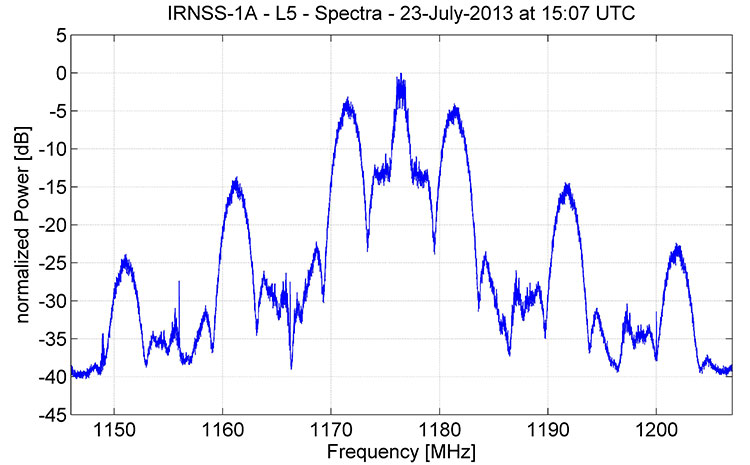
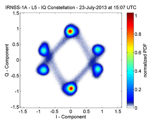
The spectrum of signals from IRNSS-1A, the first satellite in the Indian Regional Navigation Satellite System, as recorded by German Aerospace Center researchers in late July, appears to be consistent with a combination of BPSK(1) and BOC(5,2) modulation.
Figure 1 shows that, centered at 1176.45 MHz, the signal has a single symmetrical main lobe and a number of side lobes characteristic of the signal structure that the Indian Space Research Organization (ISRO) announced would be used for IRNSS transmissions in the L-band. Figure 2 shows the corresponding IQ constellation diagram. Further analysis will be required to sleuth additional signal details as ISRO, so far, has not publicly released an IRNSS interface control document describing the signal structure in detail.
Figure 1. Spectrum of IRNSS-1A L5 signal.Figure 2. IQ constellation diagram of IRNSS-1A L5 signal.
The German scientists caution that “this is a very early snapshot of the current signal transmission and probably both the signal power and the signal quality will change and possibly improve during the in-orbit-testing phase of the satellite’s operation.
Extra Life for IIRs, IIR-Ms
U.S. Air Force engineers are testing on-orbit a technique to extend the life of the 19 GPS IIR and IIR-M satellites on orbit, roughly 60 percent of the current contellation.
A new charging method may reduce the rate of satellite battery degradation, thereby extending satellite operational life. If the technique passes the test, the initiative could add a combined 20 years to the life of the satellites — saving the Air Force tens of millions of dollars in the process.
Gen. William Shelton, commander of Air Force Space Command, credits Capt. Jacob Hempen of the Air Force’s 2nd Space Operations Squadron for the job. Capt. Hempen says in turn that Warren Hwang of the Aerospace Corporation originated the idea.
When satellite solar panels are directly exposed to the Sun, they charge satellite batteries while continuing to power other operations onboard the space vehicle. When the satellite passes into the Sun’s shadow behind the Earth, it runs on batteries. The batteries can be re- charged at variable rates. When some of the batteries are powered above a certain rate threshold, they can overheat, accelerating their natural rate of decay.
Lowering battery charging rates could still enable the satellites to perform well while minimizing the rate of degradation. Hitting the optimum number called for some finely-honed calculations.
The satellites were built by Lockheed Martin Space Systems, and the oldest still in operation was launched in 1997.
They had an intial design life of eight years, which many have now well outlasted. If the technique proves out and is carefully applied across the board, it could conceivably fill in replenishment gaps equivalent more than two additional spacecraft — conceivably as much hundreds of millions of dollars in build and launch costs, postponed. In today’s budget environment, a postponement can be construed as equivalent to outright savings.
System Briefs
GLONASS Partial Make-Good. Russia will launch two GLONASS satellites later this year to make up for the loss of three satellites in the July 2 Proton rocket explosion. The first is scheduled for the beginning of September, and the second at the end of October. Both will rise aboard Soyuz carrier rockets, which have proven more reliable than the Protons. A constellation of 29 GLONASS satellites is now in orbit, with 24 spacecraft in operation, three spares, one in maintenance, and one in test flight phase.
Meanwhile, plans to reduce GLONASS funding have alarmed at least some deputies of the Duma, the Russian state legislative body. Government officials have floated a plan to reduce funding of the space program in 2014 by 11.7 billion rubles ($355 million), by 13.5 billion rubles in 2015, and by 40 billion rubles in 2016. The federal space program of Russia for 2006-2015 already lacks 10.5 billion rubles funding, and this year there has been a 2.3-billion-ruble additional reduction in R&D. A Duma committee chairperson warned that this trend will “lead to the loss of confidence of the international community in the GLONASS system and, consequently, to a reduction in its use globally. Russia will lose a strategic global instrument of political and economic prestige.” The Duma has recommended that the government maintain funding of federal space programs.
Galileo Satellites’ Trial By Noise. The first Galileo Full Operational Capability (FOC) satellite successfully completed acoustic testing in July, part of a full-scale test campaign at ESA’s ESTEC Test Centre in Noordwijk, the Netherlands.
The satellite was placed in the Large European Acoustic Facility (LEAF), effectively the largest sound system in Europe. A quartet of noise horns embedded in a wall of the 11 x 9 x 16.4 meter test chamber generated an acoustic noise level of 140.7 decibels, about the same noise as standing 25 meters from a jet taking off, and intended to simulate the extreme environment experienced by a satellite atop a rocket about to fire itself off the launch pad.
A second FOC satellite arrived at ESTEC on 9 August from manufacturer OHB in Bremen, Germany. It will undergo a similar acoustic testing and then a System Compatibility Test Campaign will linking it with the Galileo Control Centres in Germany and Italy and ground user receivers as if it were already in orbit.
A total of 14 FOC satellites are being produced and then tested at ESTEC as an integral part of their path to orbit. A second work order of eight satellites has been given to OHB.
GPS III Pathfinder. On July 19, Lockheed Martin delivered a full-sized, functional prototype of the next-generation GPS satellite to Cape Canaveral Air Force Station to test facilities and pre-launch processes in advance of the arrival of the first GPS III flight satellite.
The GPS III Non-Flight Satellite Testbed (GNST) paves the way for the first flight GPS III satellite, expected to arrive at the Cape in 2014, ready for launch by in 2015.
An innovative investment by the Air Force under the original GPS III development contract, the GNST has helped to identify and resolve development issues prior to integration and test of the first GPS III flight space vehicle (SV-01).
Following the Air Force’s rigorous “back-to-basics” acquisition approach, the GNST has gone through the development, test and production process for the GPS III program first, significantly reducing risk for the flight vehicles, improving production predictability, increasing mission assurance and lowering overall program costs.
Lockheed Martin is currently under contract for production of the first four GPS III satellites (SV 01–04), and has received advanced procurement funding for long-lead components for the fifth, sixth, seventh and eighth satellites (SV 05–08).
GNSS Industry Survey. Here are the results of two questions asked about government and industry from the 2013 GNSS STATE OF THE INDUSTRY SURVEY.
Is government committed to private industry in a time of drastic budget cuts?Is industry actively making its concerns known to government?
Everything has a geospatial aspect. Everything. Past, present, future.
Over grits, coffee, and the airborne delicacy purveyed at the Flying Biscuit Cafe (right out of the oven, right into your mouth) in Sandy Springs, Georgia, I absorbed this high-tech homily.
You’ve heard of the European financial crisis. Trace it back to geospatial, from the Greek banking collapse, which in turn had roots in the implosion of the Greek tax system, due to a plethora of gaps, inconsistencies, and exceptions filed in a largely uncontrolled property cadastre — the register of real property, including details of ownership, precise location (by GPS coordinates), and value of land parcels.
Lose control of your cadastre (your GIS), lose the country. With global interconnections, soon the continent, if not perhaps the world economy.
For want of a nail, the battle was lost.
Jump forward, technologically, to flash lidar. Ball Aerospace created this ability to capture continuous rapid multiple laser interferometry detection and ranging (LiDAR) images/point clouds, merged with continuous high-resolution optical images, to create full-color 3D models in real time. Stitched together with GPS, this produces real-time full-motion video: interactive geo-referenced metric 3D models.
In field application, this can yield time-critical 3D mapping for urgent missions, enhanced situational awareness, battlefield characterization, and tactical mission planning. It can help with disaster-response planning and event forensics. Real-time models could be communicated with the public through easily comprehended moving images via television or the Internet. of the actual progress of a fire or flood, together with evacuation routes.
Jump again to fabfi. What’s a fabfi?
FabFi is an open-source, lab-grown system out of MIT using common building materials and off-the-shelf electronics to transmit wireless Ethernet signals across distances up to several miles. Communities can build their own networks for high-speed Internet connectivity, and access to online educational, medical, and other resources.
Simple, low-cost, and feasible in unstable environments: Afghanistan, Kenya, and any number of countries that leapfrogged telephone landlines to come quickly into the cellular era; now they can leapfrog Ethernet cable networks and even Wi-Fi for virtual connectivity. Implement with locally available materials. Print out a 2D design file and create the pieces out of wood, metal, acrylic, clay, stone, or ice, as long as you can attach a metallic RF reflective surface to the front.
If you haven’t guessed the geospatial aspect of this, I assure you it’s there, but I’ve run out of room here.
Alan Cameron is editor-in-chief and publisher of GPS World magazine, where he has worked since 2000. He also writes the monthly GNSS System Design e-mail newsletter and the Wide Awake blog.
A few months ago I wrote in the magazine’s Out in Front column about the surprising abundance of BeiDou-centric papers to be presented at the upcoming ION GNSS+ conference, to which I very much look forward — both the abundance and the conference as a whole. With GLONASS encountering stormy weather of late, and Galileo plugging steadily along but not quite making up time, it seems increasingly possibly that the first GNSS of choice may constitute GPS+BeiDou, if certain spectrum questions can be worked out. News of an advance in Australia further heralds this likelihood.
Researchers at Curtin University in Perth, Western Australia, have put forth a method integrating GPS and BeiDou signals, in an effort particularly aimed at urban canyons. In Australia at least, the visibility of BeiDou’s five geostationary and five inclined geosynchronous orbit satellites hovering above the Asia-Pacific region can bring added punch to any receiver experiencing skyviews obscured by skyscrapers. The same problem occurs in open-pit mines, said Curtin University professor Peter Teunissen. Open-pit mines are a very big thing in Australia.
For those surprised to find this flying Dutchman, the inventor of the LAMBDA method for GNSS carrier phase ambiguity resolution, popping up in Australia, it appears he has a secondary appointment at Curtin University. He remains based, as he has for 20 years, at the Delft University of Technology in the Netherlands, where he is head of the Department of Earth Observation and Space Systems.
I wish I had a secondary appointment somewhere.
“By combining GPS with Beidou,” announced Teunissen and colleagues at the Cooperative Research Centre for Spatial Information, “we are making use of Beidou’s 14 new satellites that cross our sky at a high angle, increasing satellite availability, improving positioning capability and ultimately creating a system that is perfect for both urban and mining environments.”
Beidou of course has a ways to go to achieve its fullness at 35, perhaps as soon as 2020. Combining all and sundry GNSS, more than 100 GNSS satellites are expected to be operational by 2016, so algorithms making use of multiple signals and systems have moved to the fore. As we well know.
“The emergence of new GNSSs, together with the linking of different systems, has enormous potential for improving the accuracy, integrity and efficiency of positioning worldwide, enabling much more reliable data,” Teunissen added.
Precise positioning services could boost Australia’s gross domestic product by $13.7 billion by 2020, according to a recent report by a consultant for the Department of Industry, Innovation, Climate Change, Science, Research and Tertiary Education. (Maybe that’s where I should seek my secondary appointment; they’ve got a lot on their plate.)
In January of this year, Teunissen’s Curtin University group and Dr Dennis Odijk, from the Western Australian School of Mines (WASM), also announced a methodology integrating GPS with Galileo signals. Both projects were funded by the Australian Space Research Program.
Welcome to the club, India, and happy Birth Day. With the July 1 launch of IRNSS-1A, India and the Indian Regional Navigation Satellite System have officially joined the GNSSS (Global Navigation Satellite Systems Society).
With full membership, however, come some society duties and responsibilities. Chief and first among these is to provide all other society members and interested parties with an interface control document (ICD) defining the characteristics of the signal transmitted from one’s satellites to navigation receivers on the specified radio frequency(ies).
IRNSS signal transmitters will operate in L5 band (1176.45 MHz) and S band (2492.028 MHz). The system targets provision of an absolute position accuracy of better than 10 meters throughout the Indian landmass and better than 20 meters in the Indian Ocean, as well as a region extending approximately 1,500 kilometers around India.
Who needs an ICD now, you ask? Who wants to navigate the Straits of Hormuz or New Delhi’s traffic jams using one satellite? No one, of course.
But nearly every GNSS product developer, designer, and manufacturer has a vested interest in quickly getting their hands on such a document, if they want to sell goods in India, a market of very significant size. Development, design, and manufacture cycles are long, especially when you begin with new and unknown quantities such as a new signal in space. IRNSS once posted a very aggressive schedule: beginning in 2011, it planned to launch two satellites per year, to achieve a full constellation of seven by the end of 2014. Of course, it has fallen a bit behind that curve with first launch in 2013. This would push its operational date to end of 2016. Not all that far out.
As our OEM editor Tony Murfin wrote last year in a BeiDou context, developers are building digital signal processing application-specific integrated circuits with so-called generic reconfigurable channels to accommodate future add-ons — but RF front-end hardware and signal processing software still require lengthy research and development. Generic DSP channels and associated software decoding algorithms may not be generic enough for all the things that might await in new modulation schemes yet to come online.
So it’s not just rabid intellectuals like the Noble New Brunswegian, my friend, colleague, and GNSS mentor and our intrepid Innovation columnist, who prodded me up on this bully pulpit to ask: O India, where is thy ICD?
The world’s breadth and depth of GNSS wants to know.
Real-time 1-2 meter GPS accuracy in the palm of your hand — a spanking new June T41 rugged handheld computer from Trimble is up for grabs. One lucky winner of the drawing among all entrants who complete the 2013 State of the GNSS Industry Survey will take it home. Other raffle prizes also offered.
In addition to a handheld computer and smartphone configuration, the Juno T41 includes enhanced, real-time 1-2 meter GPS accuracy and high-speed 1D/2D barcode imaging technology.
The 2013 State of the GNSS Industry Survey is going on now at env-gpsworld-integration.kinsta.cloud/State13, until August 10. The survey covers economic outlook, technological frontiers, industry concerns including “The Issue of the Year,” and several questions specific to vertical industry sectors. All those completing the survey will be entered into a drawing to win the Trimble Juno T41.
Prizes. Those completing the survey will be entered into a drawing to win (First Prize) the Trimble Juno T41 rugged computer with GPS; (Second Prize) a pair of tickets to GPS World’s 2013 Leadership Dinner (for those not attending ION, we’ll send a voucher for a comparable dinner in your hometown); (Third Prizes) $50 Mastercard gift cards.
The results will be published as the “State of the Industry Report” in the September issue of GPS World, and analyzed in an August 15 webinar, register here.
New this year, the Survey delves into topics of specific interest to the following industry sectors:
Also new this year, the Survey contains a healthy sampling of questions suggested by participants in the 2012 Survey, in response to “What question(s) do you think it would be interesting and illuminating to ask in the 2013 State of the Industry Survey?”
Note that this is an industry survey, with core questions about business outlook, issues of business concern, revenue ranges, and GNSS products supplied, specified, or purchased. Thus, some GNSS community members from academia or government may find that they cannot answer many of the questions — and a majority of the questions must be answered to qualify for the prize drawing. We regret this — we don’t mean to exclude such members of the community, but in this project our goal is to build a picture of the industry.
Call it irony, poetic justice, or just the nature of the beast. The same impulse that led to the invention of GPS now has engendered a drive to beget non-GPS.
In the 1970s, the U.S. military began putting together a program “to drop five bombs in the same hole.” The program office, to the wall of which that mission statement was tacked, went on to develop the first satellite navigation positioning system: GPS. In 2012, the U.S. Defense Advanced Research Projects Agency (DARPA) declared that this system no longer sufficed for reliable delivery of precision munitions under every circumstance.
“More than 98 percent of the missiles currently in the U.S. arsenal have mission durations of less than 20 minutes, and today, almost all of these missions are critically dependent on GPS for achieving the required level of delivery accuracy,” a communiqué stated.
Because of vulnerability to jamming, spoofing, and other intentional or unintentional modifications of position, orientation, and time information, the agency has put forth a new goal “to completely eliminate dependence on GPS or any other external signals during the mission and rely solely on self-contained solutions such as inertial navigation,” which is immune to such extrinsic actors.
The Chip-Scale Combinatorial Atomic Navigator program has made 10 exploratory grants to investigate and develop this concept, to large corporations, a small start-up, national labs, and academic groups. Only one has been announced, by contracting agent Wright Patterson Air Force Base, to AOSense. DARPA wishes to emphasize that this is a sample of what is happening in C-SCAN, and should not been viewed by readers as the only technical approach paving the way.
The company, located in Sunnyvale, California, has gotten busy building an experimental navigation-system-on-a-chip that combines traditional, solid-state, and atomic inertial guidance technology. Their goal: create a sensor on a chip that works reliably, without drift, over considerable distances for at least 20 minutes.
AOSense is exploring how to shrink and fabricate atomic sensors together with high-performance solid-state inertial sensors. DARPA hopes the C-SCAN program will lead to a breed of inertial microsystems, with a wider range of operating conditions and greater immunity to the environment, reduced start-up time, increased sensitivity, and improved bias and scale factor stability. Oh, and not cost too awful much per piece.
Another project at Northrop Grumman seeks to develop a micro-gyro for personal and unmanned vehicle navigation.
Despite impressive micro-PNT work to date, current mechanisms remain complex, bulky, power-hungry — and pricey. They have limited resolution and poor long-term stability. Alternative forms give excellent resolution and bias stability, but are limited in bandwidth and generally do not allow high-frequency measurements.
Make no mistake, however. Yankee (and whatever other forms that can be brought to bear) ingenuity will, eventually, win the day. Where then will GNSS find itself?
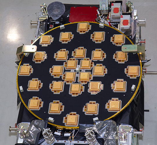
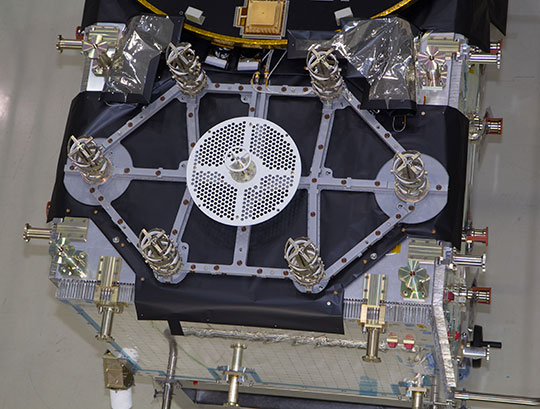
The European Space Agency (ESA) has released detailed views of the next batch of Galileo satellites, the first of which cuurently performs under simulated space conditions at the ESTEC technical center in Noordwijk, the Netherlands.
The first Galileo Full Operational Capability (FOC) satellite is functionally identical to the four Galileo In-Orbit Validation satellites already in orbit, but has been built by a separate industrial team. All 22 FOC satellites so far procured by ESA have as prime contractor OHB in Bremen, Germany; Surrey Satellite Technology Ltd. in Guildford, UK, produces the navigation payloads. The photos shown here were taken at OHB.
The satellite’s body measures 2.5 x 1.2 x 1.1 meters (8.2 x 3.9 x 3.6 feet), and it weighs approximately 733 kilos (1,616 pounds). Atop it in these photographs (although on the underside when orbiting Earth) is the circular L-band antenna that will continuously broadcast navigation messages.
The smaller, hexagonal antenna beside it will pick up emergency messages from vessels in distress and relay location and other information to search and rescue authorities, contributing to the international Cospas–Sarsat system.
A second Galileo FOC satellite is due to also travel to ESTEC this summer, preparing for a launch later this year.
L-Band antenna of the FOC satellite. Photo: ESAemergency signal antenna of the FOC satellite. Photo: ESA
L2, L5 CNAV Testing
The U.S. Air Force Space Command began testing civil navigation (CNAV)capabilities on the GPS L2 and L5 signals on June 15 and was scheduled to continue until June 29. Civil users and manufacturers were invited to participate.
According to the GPS Directorate, the CNAV live-sky testing program will span several years and will evolve to support GPS enterprise and modernized civil navigation performance objectives. Objectives include:
◾ Verify and validate the CNAV requirements specified IS-GPS-200F and IS-GPS-705B.
◾ Facilitate the development of robust IS-compliant L2C and L5 civil receivers.
More information about the testing is available in a 52-page PDF, including sections on test strategy, event conditions and constraints, operational environment, test support resources and data collection, evaluation methodology, risk assessment, and reporting.
The L2 CNAV data is an upgraded version of the original NAV navigation message. It contains higher precision representation and nominally more accurate data than the NAV data. Two out of every four packets are ephemeris data and at least one of every four packets will include clock data, but the design allows for a wide variety of packets to be transmitted. Only a fraction of the available packet types have been defined; this enables the system to grow and incorporate advances.
One packet contains a GPS-to-GNSS time offset, enabling interoperability with other global time-transfer systems such as Galileo and GLONASS, both of which are supported. The extra bandwidth enables the inclusion of a packet for differential correction. Every packet contains an alert flag, to be set if the satellite data cannot be trusted. Users will know within six seconds if a satellite is no longer usable, important data for safety-of-life applications such as aviation.
The system is designed to support 63 satellites, compared with 32 in the L1 NAV message.
Possible New GPS Launch Option
The U.S. Air Force Space and Missile Systems Center (SMC) has signed a Cooperative Research and Development Agreement with Space Exploration Technologies Corp., better known as SpaceX, as part of the company’s effort to certify its Falcon 9 v1.1 Launch System for National Security Space (NSS) missions.
SMC and SpaceX will look at the Falcon’s flight history, vehicle design, reliability, safety systems, and other aspects. Once the evaluation is complete, the SMC commander will determine whether SpaceX has the capability to successfully launch NSS missions using the Falcon 9 v1.1.
Currently, United Launch Alliance’s Delta IV and Atlas V are the only certified launch vehicles capable of lifting NSS payloads — such as the GPS satellites — into orbit. The addition of multiple certified launch vehicles provides more options to place needed capabilities on orbit. While certification does not guarantee a contract award, it does enable a company to compete for launch contracts. Those contracts could be awarded as early as Fiscal Year 2015 with launch services provided as early as FY 2017.
GPS III Funds Cut, GPS IV on Horizon?
According to a U.S. Department of Defense (DoD) spending plan released on June 1, space programs were relatively protected in an environment of across-the-board budget cuts known as sequestration. Specifically, although the budget for GPS III has been reduced for both 2013 and 2014, the reductions still allow the proposed program to stay on course. The cuts amount to about $58 million from GPS III and its associated ground system.
Congressional lawmakers proposed spending $77 million less next year for the GPS III satellite and ground systems than proposed by the Air Force, which asked for nearly $1.1 billion.
Currently, the Air Force has eight GPS III satellites contracted with Lockheed Martin Space Systems, and current plans call for the purchase of 12 further satellites with improved capabilities.
GPS IV. Gen. William Shelton, commander of Air Force Space Command, floated the possibility of a new look for the constellation on Capitol Hill. In an April 25 House hearing, Shelton said the Air Force will study this fall whether to buy another 12 GPS III craft or move on to a new generation of satellites.
“Would it be better to continue [GPS III] as opposed to starting a whole new fourth generation?” asked Representative Doug Lamborn of Colorado. “That’s the decision we will have to make in the fall,” replied Shelton. “It seems like the answer would be ‘yes’ but we will study that.”
A key aspect of the next-next gen satellite would have to be dual-launch capability. The reduction in expense this would furnish is in higher and higher demand as time goes by. Both Lockheed and Boeing are reportedly in talks with the Air Force regarding IV.
System Briefs
GLONASS Embezzle Imbroglio. The Russian Federal Security Service is investigating the embezzlement of billions of rubles from the construction of the GLONASS center in Korolyov, a town outside Moscow, as reported by Izvestia.
Construction of the GLONASS control and support center began in June 2010 on the site used by TsNIImash, the head research company of Russia’s federal space agency. The center was supposed to hold equipment for collecting and processing the data supplied by the GLONASS global network.
The construction was financed by a federal program, with 1.050 billion ($33.22 million) allocated for the project. By the end of 2010, it came to light that construction costs had been overstated, Izvestia reports. An expert appraisal revealed that the contractor had rigged the costs. The government did not allocate additional funds, so construction was suspended in December 2011 when the Federal GLONASS Program for 2002-–2011 ended. The construction of the building has never been completed.
In November 2012, the general designer of GLONASS, Yuri Urlichich, was dismissed from his post as a result of the scandal.
IRNSS Nav Center, July Launch. The Indian Space Research Organization (ISRO) Navigation Centre for the Indian Regional Navigation Satellite System (IRNSS) was inaugurated May 28, at the Deep Space Network complex at Byalalu, near Bangalore, India.
IRNSS, an independent navigation satellite system being developed by India, will have a constellation of seven satellites in geostationary and inclined geosynchronous orbits. IRNSS coverage will extend over India and the southeast Asia region. The ISRO Navigation Centre (INC) is responsible for providing the time reference, generation of navigation messages, and monitoring and control of ground facilities including ranging stations of IRNSS. IRNSS will establish a network of 21 ranging stations geographically distributed primarily across India to provide data for the orbit determination of IRNSS satellites and monitoring of the navigation signals.
On June 15, India’s Economic Times reported that a new launch date (postponed from previously announced June 11) was set for IRNSS-R1A or 1A, the first IRNSS satellite: July 1 at 18:13 UTC.
Beidou Jammed. A Beidou satellite is now believed to have experienced interference from a complex electromagnetic environment, which cut off signal transmissions in 2007, China’s People’s Daily reported. A team of scientists was able to overcome the interference issue in less than three months by 2008.
Wang Feixue, a scientist specializing in the Beidou navigation system and a senior colonel in the People’s Liberation Army said, “Had they not been able to recover the signal within three months, future satellite launches would have been indefinitely delayed. And satellites already launched would have been put out of operation.”
EGNOS Contract. A new European Geostationary Navigation Overlay Service (EGNOS) service provision contract was signed June 26 at the European Commission Vice President Antonio Tajani’s office in Brussels. The contractee is again the European Satellite Services Provider (ESSP), founded in 2001and in 2008 transformed into ESSP SAS and moved from Brussels to Toulouse.
Its shareholders are seven European air navigation service providers: Aeropuertos Espanoles y Navegacion Aerea (Spain), Deutsche Flugsicherung GmbH (Germany), Direction générale de l’Aviation civile (France), Ente Nazionale Di Assistenza Al Volo (Italy), National Air Traffic Services (UK), Navegação Aérea de Portugal, and Skyguide (Switzerland).
Back around 1992, in the early days of the World Wide Web, a starry-eyed pundit trumpeted “The Internet will do for information what TV did for entertainment!”
“Uh-oh for information,” riposted an editorial cartoonist at the time.
To be sure, television since the 1950s has brought a few new high points of entertainment into homes around the world, as well as faster and farther-reaching news coverage. It has also brought widespread new lows, entire days’ and evenings’ worth of dumb-down, and news that is broad but shallow. In the process television birthed the terms “a vast wasteland” and “sound bite.”
The Internet followed a similar path. As a consequence, more information is far more widely available. But is it any better, more reliable, more accurate, or conducive to better decisions? A strong argument can be made for the position that it is not; that, on the contrary, it is actually worse, or at the very least, less robust.
At the same time that the Web began climbing into society’s lap, nevermore to budge, the cellular telephone attached
itself to the human ear, not merely in the accustomed indoor stationary position but on the street, in the supermarket aisle, at the restaurant, behind the wheel. Now the smartphone has taken over that role and staked its ownership to the field of view as well, if not to total sensory consciousness.
And what do you know? Along came GPS in the technological bargain. All apps, if not all things, become possible when you combine: Internet, mobile phone, and satellite-based positioning.
From the interbreeding of these three springs the latest guest to the party: Big Data.
What the heck is big data?
“Data sets . . . gathered by ubiquitous information-sensing mobile devices, aerial sensory technologies (remote sensing), software logs, cameras, microphones, radio-frequency identification readers, and wireless sensor networks. The world’s technological per-capita capacity to store information has roughly doubled every 40 months since the 1980s; as of 2012, every day 2.5 quintillion (2.5×10¹⁸) bytes of data were created.”
I had to check Wikipedia (I know, I know, the prophet hoisted by his own petard) because I had only a vague sense of it myself.
According to Adam Jacobs, writing in the ACMQueue of the Association for Computing Machinery, big data is so hefty that “[its] analysis requires massively parallel software running on tens, hundreds, or even thousands of servers.”
Sounds like a job for Biggest Brother.
Indeed, the government has stepped forward to shoulder the burden; we have only just learned that it did so some time ago. Now not only our phone calls but our locations, our travels, our appointments, can be well known to anyone behind the giant curtain who has a curiosity. If they feel bothered enough to get a warrant, warrants can be got. Cases on record show that the government has opened personal cell-phone records both with and without warrants.
To rehearse the evident, those records now contain our location data. Breadcrumbs. The granularity, the precision, and the hertz-rate of that location data will only increase over time.
This time around, the “uh oh” comes from the information.
Recently released views of the next two Galileo satellites in the European Space Agency’s testing lab, along with dual-launch rumblings from the U.S. Air Force and Lockheed Martin, occasion this story about two birds with one drone. That is, an unmanned autonomous vehicle bound for the exosphere. The rest of the GNSS world is on board with this topic; isn’t it about time GPS caught up?
The first two Galileo Full Operational Capability (FOC) satellites will launch as a pair, earlier advertised as a September blast, now possibly delayed until December; a second dynamic duo will follow sometime thereafter. Then two again, and two, and two, until the Ariane 5 rocket launches four at once. Four!
The latest official U.S. Air Force plans say that by the ninth GPS III satellite (SV-09), the program plans to initiate programmatic and hardware changes to allow for the first-ever GPS dual launch. The motive, of course, is cost savings. The GPS program (probably) has no need to hurry, as other GNSSes do, in order to have a full constellation operative broadcasting — previous predictions about constellation gaps notwithstanding.
Even with dual launch, according to Lockheed Martin Navigation Systems vice president Keoki Jackson (and here I am drawing from Don Jewell’s Space Symposium column), from SV-09 forward the savings will only amount to about $70 million per launch, because it will require a larger launch vehicle.
Only $70 million. Well, to quote Senator Everett Dirksen, adjusting for inflation, “$70 million here, $70 million there, pretty soon, you’re talking real money.”
Take this all in the context of GPS III having reached the point that it will cost nearly $450 million to place a single GPS space vehicle and payload in orbit.
Rising costs and the possibility to combat them with dual launches constitute at least one of the driving forces behind the NavSat or NibbleSat drawing-board concept: a small GPS satellite, without the burden of other non-nav payloads.
Coincidentally, an initiative underway seeks to evaluate “new launch entrants,” according to General Willie Shelton, commander, Air Force Space Command. “If a new entrant can come in and provide a cost-effective launch capability for several launches, then we will look seriously at them as well,” he told Don Jewell in an interview nearly a year ago.
Jewell: “Why don’t we move into the arena of trying to pin down a vehicle or set of vehicles for dual launch? You and I once discussed GPS III vehicles 7-8 for that honor, and you mentioned at the time that it was a moving target. Where do we stand today?
General Shelton: Don, I think we are now probably talking about GPS III vehicles 9-10. We are still in the study phase on this issue with Lockheed Martin and United Launch Alliance. We are still trying to figure out how we would do dual launch and what kind of capabilities we need to develop. I think this is really the wave of the future…being able to put two up simultaneously will save us a lot in launch costs.”
In April of this year, John Frye, Lockheed Martin’s GPS III capability and affordability insertion manager, reiterated, in comments regarding the Delta Preliminary Design Review (dPDR) for the GPS III satellite, “The design modifications from this dPDR address ways to further reduce Air Force launch costs by $50 million per satellite through dual launch of two GPS III space vehicles on a single booster. This successful dPDR milestone sets the stage to proceed with SV09 design maturation.”
Rockets. Recently, the U.S. Air Force Space and Missile Systems Center (SMC) signed a Cooperative Research and Development Agreement (CRADA) with Space Exploration Technologies Corp., better known as SpaceX, as part of the company’s effort to certify its Falcon 9 v1.1 launch system for National Security Space (NSS) missions.
SMC and SpaceX will look at the Falcon’s flight history, vehicle design, reliability, safety systems, and other aspects. Once the evaluation is complete, the SMC commander will determine whether SpaceX has the capability to successfully launch NSS missions using the Falcon 9 v1.1.
Currently, United Launch Alliance’s Delta IV and Atlas V are the only certified launch vehicles capable of lifting NSS payloads — such as the GPS satellites — into orbit.
The Falcon CRADA may be a preliminary, tentative move towards dual-launch capability. Consider:
An earlier iteration, Falcon 9, can reportedly lift payloads of 4,850 kilograms (10,700 lb) to geostationary transfer orbit (GTO). The Falcon 9 v1.1— subject of the CRADA and scheduled for first flight in mid-2013—will use a longer first stage powered by nine Merlin 1D engines arranged in an octagonal pattern. Development testing of the v1.1 Falcon 9 first stage was just completed in June. These improvements will increase the payload capability by nearly 50 percent. The new first stage can also be used as side boosters on Falcon Heavy, which reportedly will have a capability of lifting 12,000 kg (26,000 lb) to GTO.
According to an Air Force fact sheet, the GPS III satellite has a launch weight of 8,115 lb.
The Atlas V 401 rocket, most recently used to launch the GPS IIF-4 satellite in May, has a GTO launch capability of 4,750 kg. (10,472 lb.) A steroid version of the Delta IV, the Delta IV Heavy, has a GTO launch capability of 13,130 kg (28,950 lb), more than any other currently available launch vehicle. It also carries a more substantial price tag.
To sum up these various vectors pointing largely in the same direction, GPS has a potential in the somewhat near-mid distant future of going to dual launch.
Meanwhile, this has been fait accompli for the other GNSSes.
Galileo
The first two in-orbit validation (IOV) satellites built by Astrium traveled aloft together in October 2011, as did the third and fourth IOV satellites in October 2012.
According Paul Flament, European Commission Programme Manager and Head of the EU Satellite Navigation Programme Unit, in an interview earlier this year with GPS World, “Satellites 5 and 6 will be launched in September of this year, aboard a Soyuz launcher from Kourou, and numbers 7 and 8 will follow in December.” These launches may since have been re-adjusted to later dates, respectively.
“Then, in 2013 we will see three Soyuz launches of two satellites each. We do not have the precise launch dates yet, but they are likely to be in April, June, and September. In December 2014, we expect to have the first launch using the Ariane 5 launcher, which is capable of deploying four satellites in one go. This means that by the end of 2014 Galileo will have deployed 18 satellites in orbit.
“In 2015, there will be two Ariane 5 launches, one in the middle of the year, one at the end, each carrying four satellites.”
GLONASS
Within days, perhaps, three GLONASS-M satellites will blast off together from Baikonur: GLONASS 48, 49, 50. This is only the latest of GLONASS triple launches.
As Richard Langley is my witness, the Russians accomplished a GLONASS hat-trick as long ago as September 1986! The first in a more recent series of triplets, in December 2010, failed rather spectacularly and cost Russia an estimate 5 billion roubles ($160 million), setting back GLONASS by six months. The system has since intermingled single- and triple-satellite launches.
Compass
China has demonstrated success with two dual launches of mid-Earth orbit satellites, among its constellation lodged at varied heights. Compass-M3 and Compass-M4 rose together in April 2012, as did M5 and M6 in September of that year.