Esri announced, via blog, their deprecation plan for ArcGIS 10.1. According to the announcement, at each release, Esri assesses if there are any platforms (operating systems, databases, development environments, or hardware) that are at the end of their supportability. Additionally, it reports that it reviews technology to see if any of the newer functionality has superseded older functionality. In either case, Esri tries to give as much advanced notice as possible for any changes in supported platforms or functionality through our Deprecation Plan documents.
Esri said that given the pace in the change of technology, it has been fairly conservative in what it deprecates (that is, recommends that a software feature, characteristic, or practice should be avoided, typically because it is being superseded). However, with the update to the Deprecation Plan for ArcGIS 10.1 and 10.2, plus the release of ArcGIS 10.2.1, it says it has a number of items that need to be deprecated. Esri says that many of these changes have been a long time coming (for both platforms and functionality); and also noted upcoming plans to give early notice for software that will eventually be impacted.
With the ArcGIS 10.2.1 update to the Deprecation Plan, the pattern is changing from a once-a-year release format to new updates with every release. The Deprecation Plan is also expanding to cover apps, mobile, and ArcGIS Runtime SDK products.
Following are some of the major changes reported by Esri:
There will not be a release of the ArcGIS Runtime SDKs at 10.2.1.
ArcGIS 10.2.1 will be the last release that supports Microsoft Windows XP and Windows Vista for ArcGIS for Server, ArcGIS for Desktop, ArcGIS Engine, ArcGIS Reader, and Runtime SDK (for Java and WPF).
ArcGIS 10.2.1 will be the last release that supports Microsoft Windows Server 2003 and Windows Server 2003 R2 for ArcGIS for Server, ArcGIS for Desktop, ArcGIS Engine, ArcGIS Reader, and Runtime SDK (for Java and WPF).
The ArcGIS 10.2 series of releases (ArcGIS 10.2, 10.2.1, and 10.2.2) will be the last releases that include the ArcSDE command line tools.
The ArcGIS 10.2 series of releases (ArcGIS 10.2, 10.2.1, and 10.2.2) will be the last releases that include the ArcSDE application server.
First of all, let me wish a Happy New Year to all my friends around the world and a prosperous 2014. I’m as excited as I’ve ever been about GNSS technology.
If I may ask for forgiveness from you if you live outside of the United States, I’d like to start out answering a question I’ve been asked about for several years. The question is:
Do you have a list of free sources of RTK base station data in the United States?
What is RTK? In a nutshell, RTK is 1-2cm real-time positioning. Some refer to it as “survey-grade”. Historically, RTK users have been required to setup and maintain their own RTK base station. This is expensive and inconvenient. Many federal, state and local government agencies have setup RTK bases to increase RTK efficiency for their employees. Many of them make the RTK base data available to the public for free or for a nominal cost. If you work in an area that offers one, all you need is internet access in the field and a RTK-capable GPS L1/L2 receiver.
I’ve tried to keep track of the public RTK bases I know of, so I’ll list them here. If I’ve missed one you know of, please feel free to send me a quick email at [email protected] or list it in the Comments section at the end of this article. Furthermore, if you live outside of the U.S., I’d love to hear from you if you know of a source of free RTK base data.
Please note that in the following list there are four types of RTK bases:
I’ve used an RTK rover on all three of these services. Each of them has several mount points supporting different data formats. I typically use RTCM3 format because it’s an open standard and supported by all services I’ve used. For the Leica Spider network, you’ll be presented a choice of iMAX or MAX. Choose iMAX if you’re not running a Leica rover.
To use any of the services, you’ll need Internet connectivity. In the past, I’ve accomplished this in a few ways:
SIM card inside a data collector.
MiFi device.
Wi-Fi from a work vehicle.
You can also use a commercial RTK Bridge or Repeater such as Intuicom or Base-n-ABox. Or you can create your own RTK bridge system with a notebook computer that has internet access.
No matter how you do it, you’ll need a reliable Internet connection (speed is not important).
You’ll also need some sort of NTRIP software utility. Several data collector software packages have this built-in. For software like ArcPad, DigiTerra, gvSIG, etc. that don’t have it built-in, there are some freeware utilities on the market that run on Windows and Windows Mobile and Android (for example, SXRTN or Lefebure) that handle the NTRIP tasks in the background.
Following is a list of RTK bases in each U.S. state, along with the associated website. Please note that I only list the public (government-operated) services. Also note that while most are free, some of the public operators charge a user fee. At one point or another, I’ve used a fair number of these in various states. Once you’ve used one of each (Trimble, Leica, PBO), the rest are pretty much the same.
The difference between the Trimble and Leica networks and PBO is that the Trimble and Leica networks provide a network solution that utilizes several RTK base stations in the computation. Distance-dependent errors are reasonably modeled so the user can be farther from individual RTK bases. The PBO RTK bases provide a single baseline (like everyone used to use before RTK networks were invented) so the further you are from the RTK base, the more error is introduced into the solution (roughly 1 cm + 1 ppm).
Lastly, there are a number of commercial RTK networks in most of the states listed. I’ll save that list for another day. Again, these are just the publicly run RTK bases.
After I published last month’s Is It Legal to Fly Drones for Mapping in the United States? article, I received a bit of reader feedback and attended a small conference focused on UASs for mapping. I learned and experienced a few new thoughts about UASs for mapping in the United States, so I thought I’d share them in a second installment.
In early December, I attended the UAS Precision Farming Forum, a local conference that was sponsored by Yamhill County (Oregon) and targeted at the agriculture market. Yamhill County covers 718 square miles (1,860 square kilometers) and contains a healthy number of agricultural and vineyard farms.
The conference was filled to capacity with 120 attendees, a complete lineup of speakers, and even a couple of exhibitors — not bad for a county-hosted local conference. This, and other such conferences around the United States, speaks volumes about the intense interest in UASs for agricultural uses in the U.S. For instance, the Association of Unmanned Vehicle Systems International (AUVSI) hosts an annual conference that attracts more than 8,000 attendees.
At the Yamhill conference, I was most interested in hearing what speakers, attendees and exhibitors were saying about the FAA rules on civilians flying UAVs. The FAA is pretty clear (at least when responding to me and others) about the rules for civilian use.
First of all, the most prolific user of UASs for mapping in Oregon seems to be Oregon State University, who possess eight Certificates of Authorization (CoA) from the FAA (Federal Aviation Administration) to operate UASs for research purposes, according to Dr. Michael Wing, associate professor of Geomatics. Dr. Wing explained that applying for a CoA from the FAA is an intense process requiring a lot of detail.
PROJECT
SITE
PLATFORM
SENSOR
PARTNERS
Forest Canopy/Structure
McDonald Forest
Prioria Maveric
EO
n-Link
Search and Rescue
McDonald Forest
Aerospace Vapor/VTOL
EO/IR
n-Link
Xmas Tree Research
OSU No. Willamette
Mikrokopter VTOL
EO
OSU, n-Link
Potato Research
HAREC
Lockheed/Procerus
EO/IR
Boeing, n-Link, USDA
Potato Research
HAREC
Tetracam HawkEye
EO/IR
Boeing, n-Link, USDA
Large Scale Potato Res.
Boardman
Lockheed/Procerus
EO/IR
Boeing, n-Link, USDA
Large Scale Potato Res.
Boardman
Tetracam HawkEye
EO/IR
Boeing, n-Link, USDA
Flight Research
Olympia
Tetracam HawkEye
Boeing, n-Link
Dr. Wing also presented the bill of materials (BOM) for one of the UASs they are using, a Zephyr II.
RiteWing Zephyr II – 54″ Wingspan
Zephyr II components (per OSU):
2.4GHz Tx/Rx radio
$360
4500mAh LiPo battery
$30
Airspeed sensor
$25
ArduPilot APM 2.5
$160
Canon S100
$300
RiteWing Zephyr II
$325
TTC Radio
$86
uBlox GPS module
$76
Voltage regulator
$15
Total:
$1,377
When I asked Dr. Wing about the CoA restrictions, he said the CoAs require him to have an FAA-licensed pilot on site for each mission.
If you recall from last month’s article, the FAA was very clear in responding to my queries that civilian commercial operation of UASs in the U.S. are prohibited unless the operator possesses a CoA from the FAA. Furthermore, the FAA says that commercial operation of UASs in the U.S. airspace is not allowed. The FAA is working on rules to integrate commercial UAS operation into the U.S. NAS (National Airspace System). The local AUVSI president, in his keynote speech, essentially said the same thing.
I went to the exhibition area because I wanted to talk to the exhibitors and understand who their target market was, since commercial operations of UASs are prohibited. Their answers were interesting. Their first answer was that “farmers can fly UAS as hobbyists.” Recall that hobbyists (or modelers as the FAA refers to them) can operate UASs up to 400 feet above ground level (AGL). I asked the FAA specifically about this. They say that any commercial usage of UASs is prohibited. For example, you can take the same UAS that you fly for fun, and you are permitted to fly it below 400 feet AGL. However, once you use the same UAS for commercial purposes (such as mapping your farm), you are violating the FAA rules.
When I pushed the vendor about this, his next answer was “as long as the farmer only flies it above his or her farm, they are allowed.” While I can sort of understand the logic behind his first statement, this statement didn’t make sense to me. If he’s using it for a commercial purpose, what difference does it make if it is over his own property or not? The problem I have with the vendor’s attitude is that he has little risk. It’s not against the FAA rules to sell UASs for commercial purposes. FAA rules are only violated when someone uses a UAS for commercial purposes. The bottom line: caveat emptor (buyer beware). The FAA is likely not going to pursue the manufacturer or distributor of the UAS, only the operator (the farmer).
But, is it really against FAA rules to operate commercial UASs in the U.S.? The vendor claimed that he asked the FAA, and said that you will get a different answer from the FAA depending on who you speak to. To some extent, I understand the confusion. Furthermore, when I asked the FAA to cite examples of litigation, enforcement actions, etc., I was told I would need to file a Freedom of Information Act request (FOIA), which I did about November 12. Beyond acknowledging my request, the FAA has sent nothing. I’m told from others that they have made similar requests (months ago) and have still not received the FOIA information. This certainly casts a cloud of doubt over the confidence the FAA has in its position.
Has anyone actually tested the FAA’s position in court?
Thanks to Twitter, I linked up with an attorney who is representing a UAS operator who is being sued by the FAA for flying a UAS for commercial purposes in the United States. Attorney Brendan M. Schulman says his client’s case is the first to test the FAA rules in court. Mr. Schulman says that the FAA has no basis on which to enforce the rules. He’s arguing that the “FAA’s position is based on policy statement and not an enforceable regulation.”
Schulman’s client, Raphael Pirker, a Swiss citizen and resident, was assessed a $10,000 fine pursuant 49 U.S.C. §§46301(a)(1) and (d)(2) and 46301(a)(5). The FAA argues that Pirker:
1. On or about October 17, 2011, you were the pilot in command of a Ritewing Zephyr powered glider aircraft in the vicinity of the University of Virginia (UVA), Charlottesville,
2. The aircraft referenced above is an Unmanned Aircraft System (UAS).
3. At all times relevant herein you did not possess a Federal Aviation Administration pilot certificate.
4. The aircraft referenced above contained a camera mounted on the aircraft which sent real time video to you on the ground.
5. You operated the flight referenced above for compensation.
6. Specifically, you were being paid by Lewis Communications to supply aerial photographs and video of the UVA campus and medical center.
7. You deliberately operated the above-described aircraft at extremely low altitudes over vehicles, buildings, people, streets, and structures.
8. Specifically, you operated the above-described aircraft at altitudes of approximately 10 feet to approximately 400 feet over the University of Virginia in a careless or reckless manner so as to endanger the life or property of another.
9. For example, you deliberately operated the above-described aircraft in the following manner:
a. You operated the aircraft directly towards an individual standing on a UVA sidewalk causing the individual to take immediate evasive maneuvers so as to avoid being struck by your aircraft.
b. You operated the aircraft through a UVA tunnel containing moving vehicles.
c. You operated the aircraft under a crane.
d. You operated the aircraft below tree top level over a tree lined walkway.
e. You operated the aircraft within approximately 15 feet of a UVA statue.
f. You operated the aircraft within approximately 50 feet of railway tracks.
g. You operated the aircraft within approximately 50 feet of numerous individuals.
h. You operated the aircraft within approximately 20 feet of a UVA active street containing numerous pedestrians and cars.
i. You operated the aircraft within approximately 25 feet of numerous UVA buildings.
j. You operated the aircraft on at least three occasions under an elevated pedestrian walkway and above an active street.
k. You operated the aircraft directly towards a two story UVA building below rooftop level and made an abrupt climb in order to avoid hitting the building.
1. You operated the aircraft within approximately 100 feet of an active heliport at UVA.
10. Additionally, in a careless or reckless manner so as to endanger the life or property of another, you operated the above-described aircraft at altitudes between 10 and 1500 feet AGL when you failed to take precautions to prevent collision hazards with other aircraft that may have been flying within the vicinity of your aircraft.
11. By reason of the above, you operated an aircraft in a careless or reckless manner so as to endanger the life or property of another.
“In this proceeding, the FAA uses those same policy statements as a pretext for applying federal aviation regulations to the operation of model airplanes. This approach violates the most basic tenets of regulatory law and the Administrative Procedures Act which require a valid notice and comment rulemaking process before legislative rules are issued. Both at the time of Mr. Pirker’s model aircraft operation in 2011, and still today, there exist no enforceable federal aviation regulations concerning the operation of civilian “drones,” whether that operation is for commercial purposes or otherwise. For the reasons set out below, the Administrator’s civil penalty is improper as a matter of law and the Complaint must be dismissed in its entirety.”
To view Schulman’s entire brief, click onFAA-v-Pirker. Per Schulman’s brief, he has asked the court to dismiss the case for reasons he outlines. He is awaiting the judge’s response. If the case is not dismissed, Schulman says the next step is discovery and a hearing.
On a related note, Schulman’s law firm, Kramer Levin Naftalis & Frankel LLP, announced on December 18 that they launched a new practice group named Unmanned Aircraft Systems Practice Group. Following is the announcement:
In light of the increasing use of drones for commercial purposes, Kramer Levin Naftalis & Frankel LLP has launched a practice group dedicated to providing counsel to clients in this rapidly growing industry. The Unmanned Aircraft Systems Practice Group is a multidisciplinary team of Kramer Levin attorneys who are versed in the legal complexities of the nascent commercial drone revolution.
Emerging commercial drone technology presents a number of economic opportunities, as well as the prospect of enhanced worker safety in hazardous conditions, humanitarian benefits in search-and-rescue and disaster missions, and environmental advantages through improved agriculture, energy and infrastructure management. Kramer Levin’s new practice will provide sophisticated and creative problem-solving approaches in this uncharted legal territory.
“Unmanned aircraft technology will define the next century in countless industries in the United States and will present new legal challenges in a number of areas including regulatory policy, aviation law, property rights, and intellectual property law, to name a few,” said Paul S. Pearlman, Kramer Levin’s managing partner. “As the definitive leaders in this field, we saw an opportunity to formalize a practice area led by informed attorneys who can advise clients in a wide range of industries.”
The firm is currently representing Raphael Pirker, the world’s foremost civilian drone pilot, in the first federal case ever involving the operation of commercial drones in the United States. Kramer Levin attorneys also regularly advise individuals, corporations, venture capital firms, educational institutions and robotics developers worldwide on the use of unmanned aircraft technologies in commercial, educational, public interest and scientific applications.
“The landmark case we are litigating will have enormous regulatory and economic implications for the industry’s future,” said Brendan Schulman, special counsel at Kramer Levin who has two decades of hands-on experience with unmanned aircraft and understands how the technology works and how to apply it safely and effectively. “This is a game-changing moment for forward-thinking businesses, and we are here to assist our clients navigate legal issues so they can become the next decade’s pioneers in their industries.”
In addition to Mr. Schulman, the new practice area will include attorneys from a number of existing firm practice areas including corporate, environmental law, litigation, intellectual property, insurance, government relations, and regulatory issues.
I’ll keep you updated on the FAA v. Pirker case as it evolves.
The global market for location-based applications is poised for rapid growth, as the mass adoption of global positioning system (GPS)-enabled smartphones is encouraging developers to introduce numerous advanced applications, says market research agency Frost & Sullivan.
New analysis from Frost & Sullivan finds that indoor connectivity, augmented reality, big data and wearable devices are the key technology trends likely to fuel the uptake of location-based applications. Location-based technology and data can then be combined to facilitate the development of smart spaces in every city and community.
“Location-based application developers have so far focused on the development of outdoor applications due to the adoption of GPS positioning in smartphones,” noted Frost & Sullivan Information & Communication Technologies Research Analyst Shuba Ramkumar. “However, as individuals spend more time indoors, there is a need to roll out indoor location-based applications that capitalise on various functionalities such as mapping, navigation and geo-fencing.”
According to the announcement, augmented reality technology could also be used to make location-based applications more interactive. Further, the widening ecosystem of wearable devices such as Google Glass and Samsung Galaxy Gear infuses technology into the daily lives of individuals, widening the scope of context-aware applications. However there are several challenges restricting the growth of the location-based applications market. The lack of standardisation in indoor positioning technologies such as Wi-Fi, sensors and Bluetooth is complicating the development of indoor applications. Location-based application providers will need to wait until wearable device manufacturers address the issues of limited battery life and dependence on smartphones for outdoor connectivity.
Frsot & Sullivan reports that market participants also find it difficult to monetise applications due to the absence of a clear business model. In this scenario, application developers should seek to identify new sources of revenue. They can expedite market expansion by establishing contracts with indoor venues to provide customised applications, and by working with wearable device manufacturers to create related applications.
“Stakeholders should work together to identify the most reliable and accurate indoor positioning technologies that can steer the indoor connectivity market forward,” said Ramkumar “The In-Location Alliance is one such initiative formed by market participants to discuss and resolve issues concerning indoor positioning technologies.”
CoreLogic released its annual Natural Hazard Risk Summary and Analysis detailing the most significant natural disasters that struck the United States in 2013. The report provides an analysis of the impact of hurricane, flood, tornado, wildfire and sinkhole events over the course of the year, as well as a summary of potential risk from natural hazards in 2014.
Compiled by CoreLogic hazard scientists, the report summarizes the property and structure, geographic and financial impact of natural disasters across the U.S. over the course of the year.
“Many predicted that 2013 would be a record year of catastrophic destruction, but the number of natural disasters that typically cause widespread destruction, mainly hurricanes, wildfires and tornadoes, were far less than anticipated and in comparison to last year’s record-setting hazard seasons,” said Dr. Thomas Jeffery, senior principal scientist for CoreLogic. “Interestingly, one natural hazard that tends to receive very little attention took center stage in 2013 as three separate sinkhole catastrophes took place in Florida. Though massive damage and loss of life from sinkholes is uncommon, this year’s events were large enough disasters to draw significant media coverage, raising public awareness of the true risk associated with this often-overlooked hazard.”
Among key findings, the CoreLogic 2013 Natural Hazard Risk Summary and Analysis notes:
Hurricane
• There was little hurricane activity in 2013. With only 13 named storms, just two reached hurricane classification and hurricane totals were both lower than pre-season predictions and disproportionately lower than previous hurricane seasons dating back to 2003.
• None of the storms in 2013 had a direct impact on the U.S., and as such, there was relatively minor damage related to Atlantic storms.
• The first official hurricane of the year, Hurricane Humberto, formed on September 11, just three hours short of setting the record for the latest formation of the season’s first hurricane.
Flood
• Flooding in the U.S. was moderate compared with recent years, partly due to the low number of Atlantic storms and the related coastal flooding. National flood losses for 2013 are expected to total approximately $2 billion.
• The most significant flooding event of the year was a September storm in Boulder, Colorado, which caused the damage or destruction of more than 19,000 homes and resulted in record-setting levels of precipitation and flooding affecting 17 Colorado counties.
• To identify the metropolitan areas located in transitional areas between high and low elevations and therefore at risk for catastrophic flood events, CoreLogic developed the first National Catchment Slope Map in 2013, illustrating the structural hydrology of the U.S. landscape.
Tornado
• Total tornado activity in 2013 was at a historic low, with 229 fewer tornadoes than any year in the past decade as of October 25. Nonetheless, the severity of numerous Oklahoma storms and an unusually violent wave of late-season storms affecting 12 states in the Midwest were no less catastrophic.
• Following three days of storms with numerous tornado sightings, on May 20 an EF5 tornado swept a 17-mile path through Moore, Oklahoma, killing 23 people, injuring 377 others, and causing an estimated $2 billion in damage.
• The widest tornado ever recorded, 2.6 miles at its widest point, struck El Reno, Oklahoma in early June, resulting in eight fatalities and nearly $40 million in damage.
Wildfire
• The number of wildfires and total acreage burned in 2013 were lower than both the 2012 season and the 10-year average. Excluding California, Colorado, Idaho and Washington, which perpetuated their 10-year average in terms of acreage affected, the Western states saw dramatically lower wildfire activity than in recent years.
• Several individual fires caused massive destruction, including Arizona’s Yarnell Hill Fire, which destroyed 8,400 acres and 129 homes, and Colorado’s Black Forest Fire, which burned 14,000 acres and destroyed or damaged over 500 homes and resulted in a total property loss expected to exceed $300 million.
• The Rim Fire, on the outskirts of several densely populated communities approximately 100 miles east of San Francisco, was the third largest fire in California state history, destroying only 11 homes but burning over 257,000 acres, including much of the Stanislaus National Forest and Yosemite National Park.
• Probable increase in fuel load in wildfire areas, as well as persisting drought conditions in California, Nevada, Arizona, New Mexico, Texas, Utah and Colorado, indicate potential for increased wildfire risk in 2014.
Sinkhole
• Three unusually severe examples of sinkhole activity in Florida captured public attention in 2013. A sinkhole in Seffner, Florida caused a tragic death in March when it formed underneath a man’s home. A tourist villa was heavily damaged when a 100-foot sinkhole formed near Clermont, Florida, and a 90-foot wide by 50-foot deep sinkhole resulted in the collapse of two homes in Dunedin.
• The CoreLogic sinkhole database currently recognizes 23,000 identified sinkholes, suggesting that sinkhole activity and subsequent property damage will continue to be a substantial risk across the nation and for Florida residents in particular.
“Though there have been fewer billion-dollar catastrophes over the course of 2013, history has demonstrated time and time again that a temporary reprieve from natural disasters cannot and should not be expected to continue into the future,” said Jeffery. “Going into 2014, it’s important to remember that hazard-driven property damage and loss can and does occur each year, and with the cyclical nature of some of these events, this year should be considered fair warning that next year will likely see a return to the higher average numbers of damaging natural disasters.”
According to the announcement, CoreLogic generated findings for the Natural Hazard Risk Summary and Analysis using the company’s comprehensive parcel database and natural hazard risk analytics, as well as data from reputable sources, such as the National Climatic Data Center, NIFC, EQECAT, Inc. and the National Weather Service.
For a copy of the 2013 CoreLogic Natural Hazard Risk Summary and Analysis, which includes maps, charts and images, click here.
As the end of the year approaches, I’d like to reflect on 2013. One of the new features of the GPSWorld website allows me to access webpage statistics so I can understand which articles and news items were “hot.” Following is a list of GPS World magazine’s hot topics for 2013 with some commentary from me.
While it seems everyone is conducting webinars today, GPSWorld was a pioneer in offering technical webinars more than six years ago, and they continue to be very popular today. Three of the latest webinars are:
Detect and Locate GPS Jamming
Unmanned Aircraft Navigation
What’s the Latest & Greatest? GNSS Products for 2014 and Beyond
As a side note, I’m trying to talk the GPSWorld publishers into allowing me to host a bi-monthly or monthly 60-minute radio show hosted by myself and featuring various GNSS industry guests. The show would be an informal, roundtable discussion about current events related to high-precision GNSS and similar technology. It would likely be broadcast live over the Internet as well as recorded in MP3 format so you could listen to it using your smartphone or music device at a time convenient to you. Please send me a quick email if you think this is something you’d be interested in listening to.
I wrote this article in March 2013 discussing the myriad of new RTK receivers recently introduced. Since the article was written, even more have been introduced! Smaller, lighter and cheaper is where RTK is headed. The fact that this article was GPSWorld’s second most visited web page in 2013 speaks volumes of the growing interest in centimeter-level, real-time positioning (RTK).
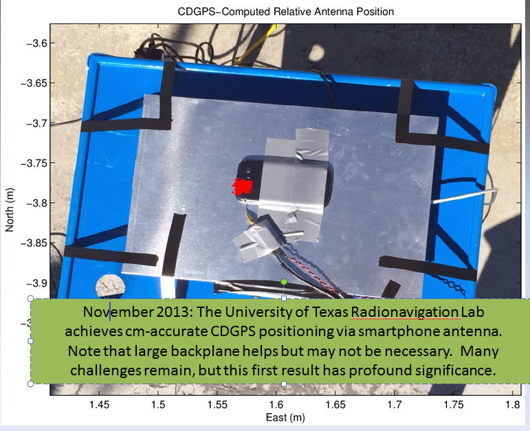
Just recently, my friends at the University of Texas at Austin (UT) took RTK where it hasn’t been before…on a smartphone.
Dr. Todd Humphreys and his graduate assistants, including Ph.D. student Ken Pesyna, are part of the UT Radionavigation Laboratory. This team has been exploring, among other things, the feasibility of implementing RTK technology on smartphones. If you recall, in 2012 at the GPSWorld dinner during the Institute of Navigation (ION) GNSS Conference in Nashville, Dr. Humphreys proclaimed that RTK technology will be readily available on smartphones and tablets by the year 2020.
Well, Dr. Humphreys and his team are doing their part to realize this vision. Just a few short weeks ago, he reported that they have enjoyed some initial success.
However, before I present the details, I’ve been reminded several times over the years that smartphone GNSS chipsets aren’t the problem. In fact, two of the key GNSS engineers on the team (Broadcom) that designed the GNSS chipset used in the Apple iPhone, Dr. Frank Van Diggelen and Charlie Abraham, used to work for Ashtech. They know RTK.
The challenge with implementing RTK in smartphones is the antenna, not the GNSS chipset.
“The smartphone GNSS antenna is nothing more than a cleverly-designed wire trace, as are all smartphone GNSS antennas,” said Dr. Humphreys. “Some have joked that you could do better with a paperclip, and that’s probably not far from the truth.”
Nevertheless, just a few weeks ago Dr. Humphreys and his team at UT were able to use a standard smartphone antenna (Samsung Galaxy SIII) to achieve an RTK solution. To his knowledge, this is the first time a successful RTK solution has been derived using an off-the-shelf smartphone antenna.
Source: University of Texas at Austin
Ken Pesyna added that RTK initialization took a little under seven minutes using seven satellites. He added that with 10 satellites in view he’s seen RTK initialization drop to about two minutes. Mind you, this is GPS L1-only. Certainly, the addition of L2, GLONASS would further reduce initialization times, not to mention BDS, Galileo, etc.
So, RTK in smartphones next year? Not so fast.
“Many challenges remain”, said Dr. Humphreys, “and in some senses we are cheating (big backplane, good clock). Nonetheless, this is a huge step forward that presages great disruption.”
He added, “We were astonished to find that we could track L2C signals through the smartphone antenna. We didn’t exploit the L2C signals in our solution, but we could have, as the L2C carrier we recovered was quite clean.”
Not far behind the RTK article, in web hits, was the article I co-wrote with Mark Silver on various free online post-processing services available to the general public. The article was super timely, as it was published a day after the U.S. government shutdown and the NGS OPUS website went blank. Therefore, thousands of GNSS users read the article in a very short amount of time.
Dr. Minghai Jia, a key developer of Australia’s AUSPOS online GNSS post-processing service, commented, “This is an excellent article, which has boosted AUSPOS demand significantly.”
Number four on GPSWorld’s website for 2013 was Tony Murfin’s article on the real-time PPP landscape.
Whereas the real-time PPP landscape remained relatively unchanged for many years, with OmniStar and Starfire services being the only games in town for satellite-based precise positioning on land (as opposed to off-shore), this landscape is changing.
In 2012, TerraStar began offering a commercial service very similar to OmniStar and Starfire — real-time decimeter positioning using corrections delivered via satellite (no terrestrial Internet connection required).
Also in 2012, Trimble introduced its satellite-based RTX service, touting 4-cm real-time PPP accuracy.
In April 2013, the IGS announced it began offering a public (free) real-time PPP decimeter service (IGS RTS). While only supporting GPS initially, IGS plans to support GLONASS by the end of 2013.
The challenge for both TerraStar and IGS RTS is that receiver manufacturers need to integrate firmware to utilize these services. It’s unlikely that those companies offering competitive services that also design GNSS receivers (Trimble, Navcom) will do so, thus making it difficult for the new services to gain market traction.
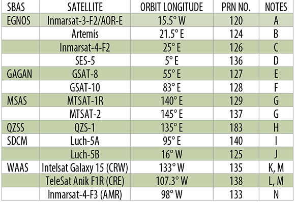
Rounding out the Top 5 GPSWorld web pages of 2013 is The Almanac, featuring GNSS constellation tables compiled by Prof. Richard B. Langley at the University of New Brunswick.
If you want a single, comprehensive webpage that lists all the navigation satellites from the various constellations, this is one you should bookmark in your web browser. Heck, there’s even a PDF version of it. GPS, GLONASS, Galileo, BeiDou, IRNSS, and public SBAS systems are listed in detail as well as many useful links to various GNSS resources.
An updated Almanac will appear in the January issue of GPS World.
If you are not quite feeling the holiday spirit, take a look at these wonderfully talented people in this four-minute music video. They don’t use any instruments besides their amazing voices.
Esri announced the release of ArcGIS for Electric and ArcGIS for Gas—ready-to-use maps and apps designed for utilities. Both are freely available to Esri customers. Developers and utility experts at Esri spent years studying industry needs and trends to come up with solutions that help utilities quickly respond to outages and engage with customers.
“It’s never been easier to geoenable your utility,” said Bill Meehan, Esri’s director of utility solutions. “ArcGIS for Electric and ArcGIS for Gas will help utilities get much more value from their data. More than that, this is a chance for utilities to truly revolutionize their business.”
ArcGIS for Electric includes damage assessment and streetlight problem apps, along with a public outage viewer to help utilities communicate with customers during an outage. ArcGIS for Gas includes damage assessment apps and an exposed pipe collector app. Both applications also help Esri customers get started quickly with ArcGIS Online, where they can create and share interactive maps and apps. They can also access ready-to-use content, apps, and templates available for the web, smartphones, and tablets.
Leica Geosystems Inc. announced new BIM Field Trip solutions to help contractors extend the value of building information modeling (BIM) into the field and connect field information back to the model in the office.
Tailored to fit any stage of BIM adoption in concrete layout, MEP layout, quality assurance, renovation/retrofit, and operations/maintenance as-builting applications, BIM Field Trip includes customized packages of hardware and software that make it easy to move from 2D to 3D workflows to achieve common BIM goals such as reduced rework, increased predictability and higher profitability, the company said.
According to the announcement, the new BIM Field Trip solutions take full advantage of Leica Geosystems’ established precision measurement technologies, such as the trusted iCON robot 50 robotic total station and popular 3D Disto laser measurement tool, as well as the latest innovations. For example, the revolutionary “BIM One Box” Leica Nova MS50 MultiStation, introduced in June 2013, offers full-featured total station layout capabilities that can handle BIM layout points from Revit, AutoCAD or virtually any other BIM or CAD program with ease, while also integrating real-time delta reporting for quality assurance checks and high definition laser scanning capabilities for capturing as-built point clouds to be compared with the as-designed model.
The BIM Field Trip solutions are available in three basic levels to help companies bridge the gaps in their BIM processes.
BIM 101 is the simplest way to get started with digital layout using paper or CAD files as a starting point. Easy-to-use, highly accurate tools such as the 3D Disto, iCON robot 50, and DISTO handheld laser measuring devices combined with intelligent, intuitive field and office software create an easy on-ramp to BIM for preconstruction as-builting, concrete layout, MEP layout, preconstruction as-builting and quality assurance. (Learn the basics of digital layout in the BIM Learning Center.)
BIM 102 provides an intermediate-level solution to help contractors improve their BIM workflows. For preconstruction as-builting, industry-leading ScanStation high definition laser scanners capture existing building conditions in the form of near photorealistic, highly accurate point clouds that can be used directly in Revit for faster and more accurate modeling. For digital layout, high-precision iCON robot 50 robotic total stations combined with intuitive field software creates a “paint-by-numbers†installation in the field that reduces errors and provides a higher level of predictability of project outcomes. For MEP and interior BIM applications, the 3D Disto combined with specialized MEP software further simplifies and streamlines interior layout. And for preconstruction as-builting, layout and quality assurance, the innovative new “BIM One Box” Nova MS50 MultiStation performs robotic layout with ease while the field software tracks the layout locations. When quality control checks are performed, any deviations are identified in real-time with a BIM delta report and can be easily scanned with the same device, producing point clouds that are automatically oriented and positioned so they flow back into the model perfectly aligned. This substantially reduces post-processing so teams can focus on comparing field data with model data to avoid rework in the field.
BIM 103 is for contractors that are experienced in BIM and want to take their capabilities to the next level. Hardware solutions such as the innovative multistation, ultrafast high-definition laser scanners and high-precision robotic total stations are combined with full featured field and office software to create advanced 3D workflows that streamline and optimize preconstruction as-builting, construction layout, and quality assurance as-builting. What’s more, the innovative “BIM One Box” multistation introduces a new era of versatility in BIM workflows with the ability to use a single instrument for preconstruction as-built point cloud data capture, replicating highly accurate BIM layout points in the field, and then high-definition laser scanning for quality assurance as-builts for comparing with as-designed models to create a complete 3D BIM lifecycle.
At each level of the BIM Field Trip, hardware and software selections are tailored to the needs of the contractor and are easily scalable from one level to the next to provide practical solutions to common BIM challenges.
“For many project teams, the benefits of BIM stop in the office; there simply hasn’t been a total solution for BIM as-builting and construction layout that connects all the dots from the model to a real-world jobsite and then from the jobsite back into the model,” said Cathi Hayes, BIM Business Manager for Leica Geosystems. “The new BIM Field Trip solutions from Leica Geosystems close the gaps by connecting the digital world to the real world. This allows companies at any stage of BIM adoption to take advantage of improved workflows.”
Trimble announced the ThingMagic Mercury xPRESS Platform, a flexible development platform designed to simplify the process of bringing application specific RFID readers and embedded RFID solutions to market. Mercury xPRESS provides market-leading embedded RFID technology with an integrated software development environment and a range of transport interfaces and communication plug-ins in a single platform. Delivered as an extensible development environment with reference design files, the platform also reduces the need for developers to have significant RFID domain expertise, facilitating the rapid integration of RFID with a variety of products and complementary wireless communication technologies.
“Simplifying the incorporation of RFID into existing and new solutions is important to the ongoing growth of our industry,” said Tom Grant, general manager of Trimble’s ThingMagic Division. “Our goal with the Mercury xPRESS Platform is to allow our customers to incorporate RFID into their applications and solutions in a timely and cost effective way. The value of RFID is becoming clearer; we need to complement that growing interest with a set of tools that make its application straight forward. That’s exactly what the Mercury xPRESS Platform provides.”
Leveraging over 10 years of RFID technology advancements and development expertise, the Mercury xPRESS Platform combines a microcontroller-based motherboard with the industry-leading ThingMagic Mercury6e Series of RFID modules and an integrated software development environment built on the ThingMagic Mercury C API. With the platform, developers can bring up a fully functional RFID reader in minutes; testing and proof of concept using sample applications from the software library can start almost immediately. Reference design files allow developers to select the elements needed for their solution and advance rapidly to application specific end product design and development. The Mercury xPRESS Platform has been screened for regulatory compliance, reducing cost and time to secure end product certifications.
Key components of the Mercury xPRESS Platform are:
-Hardware kit with microcontroller-based motherboard, including:
Integrated ThingMagic UHF RFID module (Micro, Micro-LTE, or M6e)
USB interface
Ports for up to 2 additional plug-in data transport interface modules
-MCU preloaded with sample keyboard wedge application
-An optional Bluetooth plug-in module (sold separately)
-Software toolkit and SDK (downloadable)
-Reference design files including schematics, layout files, Gerber files, bill of material, component data sheets (downloadable)
“ThingMagic is a valued technology partner of MEPS Real-Time. The introduction of the ThingMagic Mercury xPRESS Platform provides our Engineering and Marketing departments with the opportunity to offer new and innovative solutions through our Intelliguard product line,” said Shariq Hussain, president and CEO, MEPS Real-Time, Inc. “We see growth in the healthcare industry that will require smaller, faster and more capable RFID technology. With the Mercury xPRESS Platform, combined with our intellectual property, we are positioned to bring solutions to our customers that deliver world class performance and capabilities.”
The Mercury xPRESS Platform represents an alternative to using expensive general purpose readers in RFID solution designs. Lack of time, skills or resources to develop application specific readers can be much less of a barrier, resulting in unit cost savings, deployments with a stronger ROI and an overall positive bottom line impact in many deployments.
To support ongoing innovation, the integrated development tools, device drivers and application software of the Mercury xPRESS Platform may be enhanced with updates that expand capabilities and enable development of a wider range of end products. In this release, the xPRESS Platform supports USB and Bluetooth transport interface applications. Support for Wi-Fi, POE and other interfaces such as GPRS, GPS, 4G/LTE may be included in future releases at Trimble�s discretion. Mercury xPRESS is also designed to support a library of sample applications. A native keyboard wedge is available today while other sample applications may be included in future releases.
Supergeo announced that SuperSurv for iOS V0.99 is now available on the App Store for trial.
According to the announcement, SuperSurv, the mobile GIS application designed for field survey, integrates with GIS and GPS technologies to provide functions like Map Display, Query, Measure, etc, and supports point, line and polygon data collection and offline data editing. In addition to the Android edition, SuperSurv is now available for iOS users to collect spatial data.
SuperSurv for iOS V0.99 trial is now available on the App Store. OpenStreetMap can be employed as the basemap in SuperSurv to help filed surveyors collect point, line and polygon feature and the attribute data. The collected data can be saved in vector layers (SHP format) and exported through iTunes to be applied in various GIS programs.
SuperSurv for iOS full version will contain the functions, like Waypoint, GPS Track, Measure Function, Query, and reading and editing the services published by SuperGIS Server 3.1a. The full function is planned to be launched in the beginning of 2014. To learn more about SuperSurv for iOS, please download the trial on App Store.
CoreLogic announced its patented ParcelPoint technology has expanded to include data coverage for 138.5 million parcels, 97 percent of which are actual parcel boundary polygons.
According to the announcement, it is the most comprehensive parcel database in the U.S., covering 2,605 counties across the country. CoreLogic has maintained the nation’s largest parcel database since 2008, when initial coverage totaled 90 million parcels.
The company reports that the ParcelPoint spatial data provides the parcel boundaries and centroid points defined by actual latitude/longitude coordinates that are vital to identifying the geographic location of an individual property, ownership information, as well as property address and assessor parcel number (APN). Data is sourced from public records in various formats, and are then checked for geometric errors, positional accuracy, and attribution. The parcels are standardized for consistency and then incorporated into a spatial dataset to create uniform information for widespread use.