CMTINC.COM announces the release of the Utility Data Collection app for the Apple iPad. This powerful GPS/GIS mapping and data collection app was mainly designed for utility asset management and meter reading. However, it could also be used by other professionals who need to map points, lines and areas and record pertinent information for the mapped Features, such as for fish & wildlife, natural resources, land management, oil and gas, archaeology, sales route management, and others.
According to the announcement, the Utility Data Collection app provides a dedicated data entry form for entering meter readings and other observations. The meter readers can opt to have the meter route displayed on a satellite map. They will be able to tell which meters have been read as the corresponding symbols will display in a different color on the map. They will also be able to sort and search the meter records. The import and export functions makes it easy to set up meter routes, upload meter database and export meter readings.
Between the monthly meter reads, the app can be used by the maintenance crew to map the locations and record the conditions of land plots, utility poles, utility meters and other equipment. The surveyed items can be easily tagged with pre-defined descriptions as well as photos taken on the spot.
The company reports that the Utility Data Collection app is the answer for small towns and utility cooperatives who are looking to transition to a newer and more effective utility management and meter reading system on a budget.
Blue Marble Geographics announced the release of a fully managed .NET version of the GeoCalc 6.6 software development kit (SDK). Now .NET developers can get all of the accuracy and power of the GeoCalc toolkit in a fully managed .NET control. Blue Marble’s geospatial data manipulation, visualization and conversion solutions are used worldwide by thousands of GIS analysts at software, oil and gas, mining, civil engineering, surveying, and technology companies, as well as governmental and university organizations.
According to the announcement, GeoCalc is a fully object-oriented class library for software developers. Available on a number of platforms, not only does it support a massive amount of geodetic objects out of the box but the tool also has a direct connection to the OGP’s EPSG Geodetic Parameter web registry. This allows you to directly update your EPSG definitions whenever you need it and to supplement our already huge database with even more objects for coordinate transformation. Blue Marble’s geodetic toolbox leverages an XML data source, enabling secure and powerful data transformation management through interfaces and logic that allow you to lock down your datasource via password protection. The toolkit includes a variety of tools for improving data quality management from a development level allowing the software developer to work with the survey expert to provide powerful coordinate transformation software. With the release of the fully managed .NET platform, developers now can get all of the accuracy and power of the GeoCalc toolkit in a fully managed .NET control.
“This fully managed version of GeoCalc has come about from working closely with a number of our developer customers over the past year,” stated Blue Marble President Patrick Cunningham “We’re pleased to make powerful, reliable coordinate transformation available for any software environment and happy to assist our customers at the same time. When we say customer driven development, we mean it.”
The company reports that the GeoCalc fully managed SDK is built on Microsoft’s 4.0 .NET architecture. This means all of the memory management details are handled entirely by the .NET virtual machine and the CLR (Common Language Runtime). Using this standard Windows framework increases security, performance, and usability for anyone working inside the latest Microsoft development environments. This new version of GeoCalc streamlines the development process as 32 and 64 bit compatibility issues are handled entirely by Visual Studio, and the new code base means only one application needs to be delivered for both environments. The single DLL redistributable framework makes windows deployment much easier in many cases, lowering development costs and speeding up time to market.
Hexagon has announced it will offer NOK 28 in cash per share in positioning company Veripos in a public voluntary offer:
Hexagon will make a voluntary offer of NOK 28 in cash per share of Veripos, a company listed on the Oslo Stock Exchange
The voluntary offer represents a premium of 44 per cent to Veripos’ volume weighed average stock price during the three month period up to and including 11 October 2013
The offer will require acceptance from shareholders representing a minimum of 90 per cent of the Veripos share capital and voting rights, and certain other customary conditions for public voluntary offers
A five=week offer acceptance period will start shortly following the approval of an offer document by the Oslo Stock Exchange
According to the announcement, the Board of Directors of Hexagon AB has decided that Hexagon, directly or through a wholly owned subsidiary, will present to the shareholders of Veripos Inc., a voluntary offer of NOK 28 in cash per share for all outstanding shares of Veripos.
The offer price represents a premium of 21.7 per cent to the last traded price for Veripos of NOK 23, and a premium of 28.1 per cent, 43.6 per cent, 47.8 per cent and 46.3 per cent to the volume weighted average share prices (source: Bloomberg) for the one, three, six and twelve month periods, respectively, that ended on October 11.
On September 30, Hexagon contacted the Board of Directors of Veripos with a proposal of Hexagon making a voluntary offer of NOK 28 for all of the outstanding shares of Veripos, subject to due diligence and certain other conditions. On October 4, Veripos and Hexagon entered into a due diligence agreement where Hexagon was granted access to conduct a limited due diligence review on an exclusive basis. Such due diligence was concluded to Hexagon’s satisfaction on October 12.
Ola Rollén, President and Chief Executive Officer of Hexagon, said, “It is a good strategic fit between Hexagon and Veripos where Hexagon will provide, state of the art, positioning technology to Veripos as well as future growth via Hexagon’s onshore markets. Veripos has, in turn, built up a strong position in the offshore market and has world class infrastructure that Hexagon can leverage on immediately after an acquisition rather than building such infrastructure in-house.”
The offer will not be subject to any financing conditions. Hexagon’s preliminary assessment is that the offer will not be subject to any competition approval. The complete details of the offer, including all terms and conditions, will be contained in an offer document pursuant to chapter 6 of the Norwegian Securities Trading Act.
Hexagon has filed the offer document for review and approval with the Oslo Stock Exchange and the offer document will be sent to Veripos’ shareholders as soon as it has been approved. The acceptance period for the pffer will be five weeks from the date of the offer document being released, unless extended by Hexagon. The acceptance period may be extended, one or several times, provided however that the maximum acceptance period may not exceed 10 weeks.
As will be further detailed and specified in the offer document, the completion of the offer will be subject to the following conditions being satisfied or waived by Hexagon:
The offer has been accepted by shareholders representing more than 90 per cent on a fully diluted basis of the share capital and voting rights to which the offer relates;
Approvals from public authorities;
No material adverse change up until the settlement of the offer;
Conduct of business in the ordinary course and in accordance with applicable laws, regulations and decisions of any governmental body; and
Other customary conditions to be specified in the offer document.
While the offer will be subject to a completion condition of more than 90 per cent acceptance, Hexagon will retain its full right to amend or waive such condition, and hereunder also to make a compulsory acquisition of any remaining shares, subsequently to the offer, through the implementation of a so called “long-form merger” under the Cayman Company Act should the acceptance of the Offer be equivalent to more than two-thirds of the outstanding share capital and voting rights on a fully diluted basis.
The Offer will not be made in any jurisdiction in which the making of the Offer would not be in compliance with the laws of such jurisdiction. The Offer will be made to U.S. shareholders in Veripos. This notification does not in itself constitute an offer. The Offer will only be made on the basis of the Offer Document and can only be accepted pursuant to the terms of such document.
Esri published an interactive map that allows viewers to explore the top 10 metropolitan areas that could be impacted by the government shutdown based on the percentage of wages that goes to federal employees, according to Trulia.com. Click here to experience the interactive map.
Trimble has introduced the Trimble V10 Imaging Rover, an integrated camera system that precisely captures 360 degree digital panoramic images for visual documentation and measurement. The Trimble V10 Imaging Rover enables professionals in a broad range of industries—including survey, GIS, engineering, and oil & gas—to quickly capture rich, complete data of their surrounding environment. In the office, users can take measurements and create comprehensive deliverables using Trimble Business Center office software.
According to the announcement, the Trimble V10 with Trimble VISION technology, leverages calibrated imaging sensors allowing digital images to be captured directly from the range pole. Twelve calibrated cameras—seven panoramic and five downward-looking—integrated in the Trimble V10 provide complete site visualization and documentation with a 60 MP panoramic image that can be used to make photogrammetric measurements.
Easy to use with one button operation, the Trimble V10 enables geospatial professionals to perform work where there are many features to collect or where features are complex or difficult to capture, such as oil and gas industrial facilities, and capture increased amounts of data in less time. Trimble Access field software running on the Trimble Tablet Rugged PC offers a simple and intuitive process to capture and review images and store observations.
The solution works standalone or can be seamlessly integrated with the Trimble R10 GNSS receiver and Trimble S-series total stations such as the VX, S8 and S6 so that panoramic images can easily be captured along with high-accuracy positions for an accurate geospatial dataset. Combined with the Trimble Tablet and Trimble Access field software, the Trimble V10 collects visual documentation of the jobsite with corresponding positioning information for subsequent office measurement.
To quickly generate traditional and innovative deliverables, Trimble Business Center provides intuitive close-range photogrammetry tools to efficiently extract survey grade measurements from the Trimble V10 images. The rich image data can also be later mined to satisfy new customer requests, saving time and reducing the need for revisits to the job site.
“The Trimble V10 Imaging Rover ushers in a new era for geospatial data capture—positions from pictures,” said Phil Sawarynski, business area director of Imaging Solutions for Trimble’s Geospatial Division. “The capability to easily integrate panoramic images into traditional datasets and take measurements from those images sets a new standard for positioning applications.”
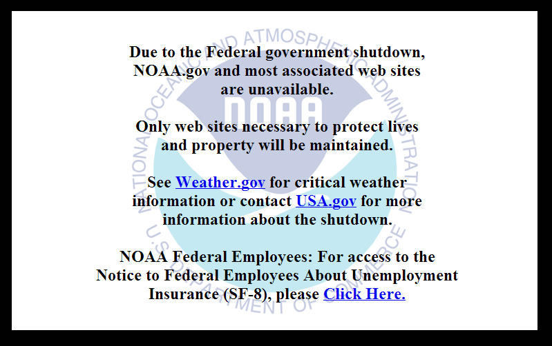
On October 1, the U.S. federal government shut down and furloughed 800,000 non-essential workers. While services considered essential remained active, those considered non-essential services, like the National Geodetic Survey’s Online Positioning User Service (OPUS), were shut down. OPUS is a free, online GPS post-processing service. If you try to access www.ngs.noaa.gov, the following screen will be displayed:
For those of you who rely on OPUS for GPS post-processing, now is a great time to try one of the other seven online post-processing services available and not subject to the U.S. federal government. Yes! I wrote seven, and the results from those seven are comparable to OPUS. The other seven, free online GPS post-processing services are:
CSRS-PPP: Canadian Spatial Reference System, Natural Resources Canada
My colleague Mark Silver, creator of the X90-OPUS receiver I wrote about a few months ago, embarked on an effort to run test data through each of the online post-processing services to demonstrate that there are free, online GPS post-processing services available worldwide that produce results comparable to OPUS. The following report is the result of his efforts:
A Comparison of Free GPS Online Post-Processing Services
By Mark Silver
You are probably familiar with the National Geodetic Survey’s OPUS suite of online post processing tools (OPUS-Static, OPUS-Rapid Static and OPUS-Projects.) These services are capable of producing centimeter-level positioning from static GPS observations. What you may not realize is there are at least six viable alternatives to OPUS.
All are free, easy to use, provide world-wide coverage, and generate surprisingly similar results.
Since each uses a unique baseline tool and processing strategies they form an excellent reality check against each other.
IGS orbits and the IGS permanent CORS arrays are used by many of the services, however some use proprietary equipment arrays and orbit products that provide additional redundancy.
How comparable are these services? Which one is the best?
Criteria for Comparing
Comparing results is a difficult proposition:
The true/correct answer for any site is unknown.
What grading scale should be used? Should elevation differences be weighted differently than horizontal differences?
Should the peak-to-peak range or the standard-deviation be prized?
Should comparisons be made on long 24-hour data sets or short 2-hour occupations?
Is a single data set sufficient for a meaningful comparison or are multiple data sets preferable?
Should a service be ‘thrown out’ of consideration because the solutions are substantially different from the mean?
The answer to all of these questions is “it depends.” Your evaluation will depend on your specific application.
For this evaluation, the following rules governed the data set selection:
Choose a site known to be stable with a clean EMI environment.
Use 24-hour observation sets to enable ‘best case’ processing.
Use a sufficiently large data set, 32-consecutive days, to expose trends.
Choose a time period, 90-days in the past, so precise orbits are available to reduce ephemeris effects.
Only consider GPS data.
Use default settings for every option on each processing service.
Scoring
This would not be as interesting without a little competition.
To keep the evaluation simple, the sum of the X, Y and Height range will be the score and the services will be ranked from lowest score to highest score, with the low score being the ‘best.’
Range was chosen as an indicator of the expected maximum error that might be encountered if only a single 24-hour file was observed.
The combined range rewards a processing scheme that best estimates delays, interference, clock errors and other sources of change that occurred during the 32-day trial.
Remember that the every aspect of this ‘competition’ is arbitrary: from the selection of observation sets, to the final scoring system.
The real take-away from this evaluation is not that one service is better, but how close all of the services are to each other.
Two services (JPS’s APPS, magicGNSS) won’t be acceptable to the average user and a third (RTX Centerpoint) may not work for some users based on receiver and antenna support. Details of these problems are presented with the service descriptions below.
The Test Data
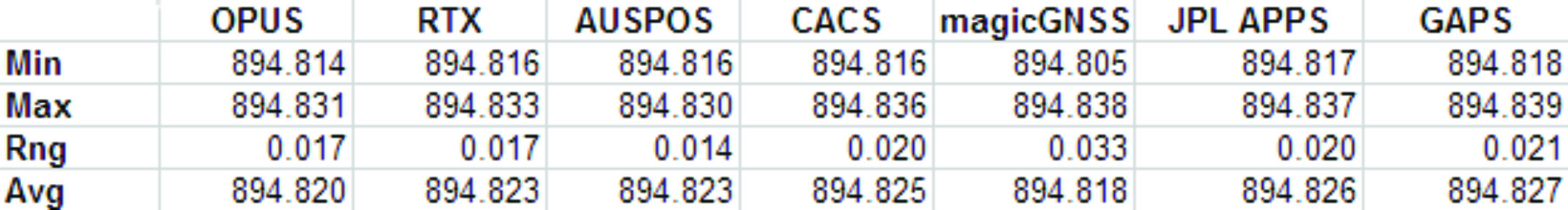
SGU1 in St. George, UT USA was chosen as the observation base. The observations consist of 32 consecutive days (May 3, 2013 through June 3, 2013), 24-hour observation files, 30-second interval, GPS only data. The data files were downloaded from the NGS CORS archive.
Each of the 32 files were submitted to each of the processing services and the results have been tabulated for X, Y and Ellipsoid Height. All data is presented in IGS08 current epoch framed coordinates. All data has been projected to UTM Meters for these comparisons.
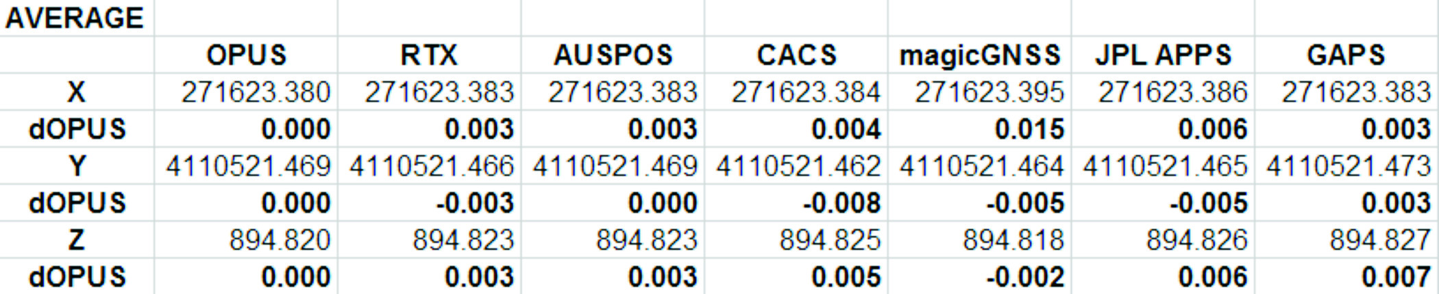
The Average Values
Remember, the real story is how close each of these services produce results to one another. Let’s look at the average positions from each service and the difference from OPUS:
Fig 1: Average Solution Difference from OPUS
As you can see in Figure 1 above, the services were generally within 5mm of OPUS in X, Y and Height.
Position Tracking vs. Time
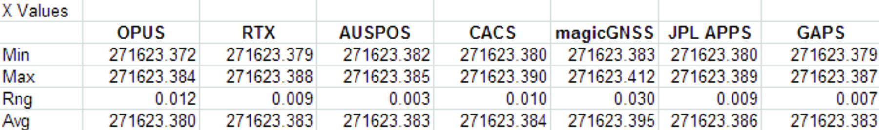
Fig 2: Service Results X vs. Time
Fig 3: Service Results X Range, Average
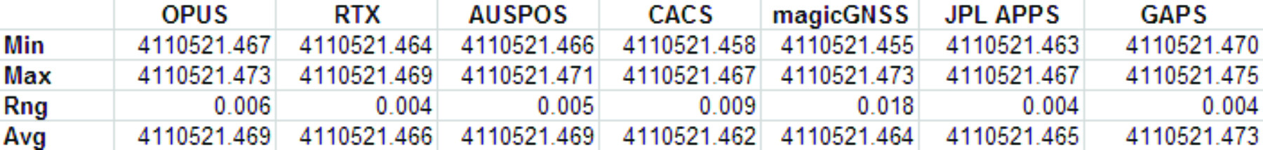
Fig 4: Service Results vs. Time
Fig 5: Service Results Y Range, Average
Fig 6: Service Results Z vs. Time
Fig 7: Service Results Z vs. Time
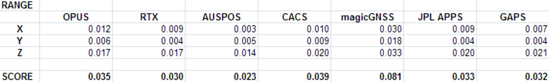
And the Winner Is…
Following are the scores, based on the combination of X, Y and Height range:
Fig 8: The Scores
Score ranking (remember this is just for fun as the services provided remarkably similar results):
AUSPOS
CenterPointRTX
GAPS
APPS
OPUS
CSRS-PPP
magicGNSS
There is a significant issue in the JPL APPS’s reported output positions, which will keep it from being of any use to most users. magicGNSS’s results are significantly different than the other services. User’s should independently evaluate magicGNSS’s suitability for their purpose. SOPAC’s SCOUT could not be evaluated because it patently does not support either the receiver or antenna that was used at the test site.
AUSPOS is a free service from Geoscience Australia. Access is via a simple web interface, the antenna height and type are entered along with a email address for the returned report set. File submission is via FTP or directly from the web interface.
The returned PDF report is the best looking of the reviewed services and includes a Processing Summary showing a map of the CORS sites that were used in the solution. SINEX files are also available.
AUSPOS uses the Bernese GNSS Software for processing baselines, IGS orbits and IGS network stations. Solutions are available for anywhere on the earth.
RINEX files need to be at least 1-hour in length, 6-hour files are recommended. Compact RINEX files are also accepted. Files may be compressed with UNIX, Hatanaka, ZIP, gzip or bzip compression.
Centerpoint RTX Post Processing: Trimble Navigation Limited
CenterPoint RTX Post Processing is a free service offered by Trimble.
It works anywhere in the world and is based on a proprietary Trimble 100+ worldwide CORS network. Accuracy is 2 cm with 1-hour of observation data; 1 cm with 24-hours. Files longer than 24-hours are not accepted.
RTX uses GPS, GLONASS and QZSS tracked SV’s.
The reported output frames include ITRF2008 at current epoch and a user selectable frame like NAD83/2011 2010.0. RTX is one of the few services that will directly export NAD83 framed results.
A single page PDF and a XML result file are returned by RTX. Unfortunately, it is not possible to copy numerical results from the read-only PDF result file to the clipboard.
RTX supports a limited number of receivers (Trimble) and a relatively small subset of IGS modeled antennas. For this test, TEQC was used to stuff the RINEX headers with a comparable Trimble receiver to the actual Ashtech ProFlex 500 receiver that is in use at SGU1. This was all that was required to spoof an accepted device. If the antenna had not been listed, it would have been necessary to spoof the antenna and adjust the height to reflect the difference in L1 phase center offset.
GAPS is an ongoing project at the University of New Brunswick and was developed by the Department of Geodesy and Geomatics Engineering.
File submission is by a web page and GAPS provides a large number of user inputs and potentially allows the highest level of customization of any of the reviewed services:
You may enter a priori coordinates, and a priori constraints
GAPS accepts static or kinematic files
You can set the elevation mask
The Neutral Atmosphere Delay model is selectable
Earth Body Tides and Ocean Tidal Loading can be applied or disabled
GAPS only processes GPS data (no GLONASS.)
Submitted filenames must adhere to the SSSSDDDh.YYt file format. GAPS accepts RINEX and compact RINEX files, they may optionally be gzip, unix compressed or ZIP compressed.
WARNING! APPS only reports the derived position to the nearest decimeter-meter in geographic (lat/lon) coordinates, while reporting ECEF coordinates to a fraction of a millimeter. If you choose to use APPS, you will need to manually convert the ECEF XYZ to geographic coordinates.
JPL’s APPS is based on GIPSY-OASIS (currently version 5). APPS uses NASA’s 70+ Global GPS Network plus densification from other systems (100+ total receivers distributed globally.) Solutions are typically available with 5 seconds delay from observation.
APPS is easy to use, you just specify a file to upload and then click on ‘Upload’ it takes only 15 seconds to get a result after the file upload is complete. You can optionally register for a free account and use email or FTP for bulk uploads.
APPS also has receiver Live Performance Monitoring: (http://www.gdgps.net/monitoring/index.html) which generates a real time graph of three receivers spread through the world.
Before using CSRS-PPP, you will need to register for a free user account.
CSRS has a fantastic desktop application named PPP-Direct that you can just drag and drop files onto. PPP-Direct automatically submits the file and saves all typing, greatly reducing the chance of error.
CSRS-PPP uses both GPS and GLONASS (if available) observables. Ocean Title Loading corrections can be overridden.
CSRS-PPP will accept single frequency files for processing. CSRS will accept RINEX and Compact RINEX, and will decode ZIP, GZIP and unix compression formats.
CSRS-PPP has a fantastic PDF report, a .csv file detailing results epoch by epoch and a great machine readable summary file.
The desktop submission tool, coupled with the great output reports made CSRS-PPP my favorite tool.
magicGNSS accepts emailed files and returns solutions by email. Turnaround time is fast and features a nice PDF report plus SINEX, receiver clock bias files, tropospheric delay, KML trajectory and RINEX CLK clock bias files.
Static and kinematic files with observations from GPS, GLONASS are processed by magicGNSS and the service reportedly Galileo-ready.
magicGNSS uses a subset of IGS stations to provide core coverage.
SCOUT: Scripps Orbit and Permanent Array Center (SOPAC). University of California, San Diego
Scout accepts RINEX and compact RINEX files, compressed (Z, gz, ZIP) submitted from an FTP site or pushed onto a provided FTP server.
Files must be generated on a limited subset of receivers and antennas. While the IGS antenna and receiver files are the basis for acceptable devices, not all IGS-listed devices are on the allowable device list. SCOUT documentation specifically warns against spoofing devices and antennas.
SCOUT uses the GAMIT processing engine.
Because the test data for this article is from a unsupported receiver and the submittal process requires a FTP host server with anonymous access which most users will not bother with, the output from SCOUT was not evaluated.
Conclusion
The similarity of results between all of the services I processed is amazing. That they differ only by millimeters demonstrates the robustness of the algorithms and processes they use.
The difference between AUSPOS, RTX, GAPS, OPUS and CSRS-PPP solutions are negligible. For important positioning projects, it undoubtedly makes sense to use them all.
For locations in the United States, OPUS and RTX return NAD83-2011 framed results. Only OPUS returns derived orthometric heights using GEOID12A. While OPUS has more provenance than the other services, it is easy enough to submit important observations to multiple services as a reality check for important positions.
###
As you read from Mark’s report above, even though OPUS is shut down until the U.S. Congress can resolve its differences, don’t let that stop you from processing your GPS static sessions. However, some level of due diligence on your part is needed as requirements vary for each service. For example, static sessions for the OPUS-RS service can be as short as 15 minutes while other services require two hour GPS static sessions. Furthermore, some services process GPS L1 data while others require both GPS L1 and GPS L2 observations.
Orbit Logic announced that their SpyMeSat iPhone app is now available on the Apple App Store. The SpyMeSat app provides notifications when imaging satellites are overhead and may be taking your picture. A dynamic map shows orbit tracks and the location of satellites with upcoming passes over the user-specified location.
SpyMeSat iPhone App
According to the announcement, this is Orbit Logic’s first app targeted for consumers outside their standard customer base in the aerospace, defense, and government intelligence communities.
“This app is for everyone.” said Alex Herz, president of Orbit Logic. “Whenever I talk to people outside the aerospace industry about what I do they have so many questions. I realized there was a place for an app to provide information, education and awareness about imaging satellites to a wider audience. And it’s fun for aerospace industry insiders too!”
The SpyMeSat app uses NORAD orbit data published online by www.celestrak.com and available public information about commercial and international imaging satellites to compute and dynamically display satellite overflights and imaging pass information. The app user can drill down to see additional details about each imaging opportunity, and the app provides a page describing each satellite for those who want to learn more.
SpyMeSat users can configure the app to enable or disable individual satellites, change the location of interest, enable or disable various notification options, and specify the resolution limit for computed passes. Orbit Logic can create custom SpyMeSat solutions for any constellation of satellites. With a custom SpyMeSat solution, authorized users can make satellite tasking requests directly from the mobile device.
ikeGPS announced a Kickstarter fundraising effort for a smartphone laser measurement and augmented reality accessory named Spike.
According to the announcement, with Spike you can measure, map, 3D model (and share) any object up to 600 feet away by taking a snapshot on your smartphone.
The company reports that Spike’s precision enables the development of immersive laser-based smartphone apps, delivering deeply textured 3D modeling and location experiences. Its laser accuracy makes Augmented Reality (AR) experiences real. Not just because Spike enables AR apps to be incredibly precise and relevant to a user for the very first time, but also because it empowers anyone to develop and experience them on their smartphone.
The fully specified API will enable software engineers to develop immersive AR applications. By embedding specialist ikeTools into the application, or building an application over the data stream from the calibrated laser camera, Spike will give applications long range accuracy and depth perception.
According to Spike’s Kickstarter webpage, the project will be funded if $100,000 is reached by October 29, 2013. As of October 2, 2013, funding was at $74,282
On October 1, 2013, the U.S. federal government shut down and furloughed 800,000 non-essential workers. While services considered essential remained active, those considered non-essential services, like the National Geodetic Survey’s Online Positioning User Service (OPUS), were shutdown. OPUS is a free, online GPS post-processing service. If you try to access www.ngs.noaa.gov, the following screen will be displayed:
Photo: NOAA
For those of you who rely on OPUS for GPS post-processing, now is a great time to try one of the other seven online post-processing services available and not subject to the U.S. federal government. Yes! I wrote seven, and the results from those seven are comparable to OPUS. The other seven, free online GPS post-processing services are:
CSRS-PPP: Canadian Spatial Reference System, Natural Resources Canada
My colleague Mark Silver, creator of the X90-OPUS receiver I wrote about a few months ago, embarked on an effort to run test data through each of the online post-processing services to demonstrate that there are free, online GPS post-processing services available worldwide that produce results comparable to OPUS. The following report is the result of his efforts:
A Comparison of Free GPS Online Post-Processing Services
By Mark Silver
You are probably familiar with the National Geodetic Survey’s OPUS suite of online post processing tools (OPUS-Static, OPUS-Rapid Static and OPUS-Projects.) These services are capable of producing centimeter-level positioning from static GPS observations. What you may not realize is there are at least six viable alternatives to OPUS.
All are free, easy to use, provide world-wide coverage, and generate surprisingly similar results.
Since each uses a unique baseline tool and processing strategies they form an excellent reality check against each other.
IGS orbits and the IGS permanent CORS arrays are used by many of the services, however some use proprietary equipment arrays and orbit products that provide additional redundancy.
How comparable are these services? Which one is the best?
Criteria for Comparing
Comparing results is a difficult proposition:
The true/correct answer for any site is unknown.
What grading scale should be used? Should elevation differences be weighted differently than horizontal differences?
Should the peak-to-peak range or the standard-deviation be prized?
Should comparisons be made on long 24-hour data sets or short 2-hour occupations?
Is a single data set sufficient for a meaningful comparison or are multiple data sets preferable?
Should a service be ‘thrown out’ of consideration because the solutions are substantially different from the mean?
The answer to all of these questions is “it depends.” Your evaluation will depend on your specific application.
For this evaluation, the following rules governed the data set selection:
Choose a site known to be stable with a clean EMI environment.
Use 24-hour observation sets to enable ‘best case’ processing.
Use a sufficiently large data set, 32-consecutive days, to expose trends.
Choose a time period, 90-days in the past, so precise orbits are available to reduce ephemeris effects.
Only consider GPS data.
Use default settings for every option on each processing service.
Scoring
This would not be as interesting without a little competition.
To keep the evaluation simple, the sum of the X, Y and Height range will be the score and the services will be ranked from lowest score to highest score, with the low score being the ‘best.’
Range was chosen as an indicator of the expected maximum error that might be encountered if only a single 24-hour file was observed.
The combined range rewards a processing scheme that best estimates delays, interference, clock errors and other sources of change that occurred during the 32-day trial.
Remember that the every aspect of this ‘competition’ is arbitrary: from the selection of observation sets, to the final scoring system.
The real take-away from this evaluation is not that one service is better, but how close all of the services are to each other.
Two services (JPS’s APPS, magicGNSS) won’t be acceptable to the average user and a third (RTX Centerpoint) may not work for some users based on receiver and antenna support. Details of these problems are presented with the service descriptions below.
The Test Data
SGU1 in St. George, UT USA was chosen as the observation base. The observations consist of 32 consecutive days (May 3, 2013 through June 3, 2013), 24-hour observation files, 30-second interval, GPS only data. The data files were downloaded from the NGS CORS archive.
Each of the 32 files were submitted to each of the processing services and the results have been tabulated for X, Y and Ellipsoid Height. All data is presented in IGS08 current epoch framed coordinates. All data has been projected to UTM Meters for these comparisons.
The Average Values
Remember, the real story is how close each of these services produce results to one another. Let’s look at the average positions from each service and the difference from OPUS:
Fig 1: Average Solution Difference from OPUS
As you can see in Figure 1 above, the services were generally within 5mm of OPUS in X, Y and Height.
Position Tracking vs. Time
Fig 2: Service Results X vs. Time
Fig 3: Service Results X Range, Average
Fig 4: Service Results vs. Time
Fig 5: Service Results Y Range, Average
Fig 6: Service Results Z vs. Time
Fig 7: Service Results Z vs. Time
And the Winner Is…
Following are the scores, based on the combination of X, Y and Height range:
Fig 8: The Scores
Score ranking (remember this is just for fun as the services provided remarkably similar results):
AUSPOS
CenterPointRTX
GAPS
APPS
OPUS
CSRS-PPP
magicGNSS
There is a significant issue in the JPL APPS’s reported output positions, which will keep it from being of any use to most users. magicGNSS’s results are significantly different than the other services. User’s should independently evaluate magicGNSS’s suitability for their purpose. SOPAC’s SCOUT could not be evaluated because it patently does not support either the receiver or antenna that was used at the test site.
AUSPOS is a free service from Geoscience Australia. Access is via a simple web interface, the antenna height and type are entered along with a email address for the returned report set. File submission is via FTP or directly from the web interface.
The returned PDF report is the best looking of the reviewed services and includes a Processing Summary showing a map of the CORS sites that were used in the solution. SINEX files are also available.
AUSPOS uses the Bernese GNSS Software for processing baselines, IGS orbits and IGS network stations. Solutions are available for anywhere on the earth.
RINEX files need to be at least 1-hour in length, 6-hour files are recommended. Compact RINEX files are also accepted. Files may be compressed with UNIX, Hatanaka, ZIP, gzip or bzip compression.
Centerpoint RTX Post Processing: Trimble Navigation Limited
CenterPoint RTX Post Processing is a free service offered by Trimble.
It works anywhere in the world and is based on a proprietary Trimble 100+ worldwide CORS network. Accuracy is 2 cm with 1-hour of observation data; 1 cm with 24-hours. Files longer than 24-hours are not accepted.
RTX uses GPS, GLONASS and QZSS tracked SV’s.
The reported output frames include ITRF2008 at current epoch and a user selectable frame like NAD83/2011 2010.0. RTX is one of the few services that will directly export NAD83 framed results.
A single page PDF and a XML result file are returned by RTX. Unfortunately, it is not possible to copy numerical results from the read-only PDF result file to the clipboard.
RTX supports a limited number of receivers (Trimble, Ashtech, Javad, some Leica, some Topcon) and a relatively small subset of IGS modeled antennas. For this test, TEQC was used to stuff the RINEX headers with a comparable Trimble receiver to the actual Ashtech ProFlex 500 receiver that is in use at SGU1. This was all that was required to spoof an accepted device. If the antenna had not been listed, it would have been necessary to spoof the antenna and adjust the height to reflect the difference in L1 phase center offset.
GAPS is an ongoing project at the University of New Brunswick and was developed by the Department of Geodesy and Geomatics Engineering.
File submission is by a web page and GAPS provides a large number of user inputs and potentially allows the highest level of customization of any of the reviewed services:
You may enter a priori coordinates, and a priori constraints
GAPS accepts static or kinematic files
You can set the elevation mask
The Neutral Atmosphere Delay model is selectable
Earth Body Tides and Ocean Tidal Loading can be applied or disabled
GAPS only processes GPS data (no GLONASS.)
Submitted filenames must adhere to the SSSSDDDh.YYt file format. GAPS accepts RINEX and compact RINEX files, they may optionally be gzip, unix compressed or ZIP compressed.
WARNING! APPS only reports the derived position to the nearest decimeter-meter in geographic (lat/lon) coordinates, while reporting ECEF coordinates to a fraction of a millimeter. If you choose to use APPS, you will need to manually convert the ECEF XYZ to geographic coordinates.
JPL’s APPS is based on GIPSY-OASIS (currently version 5). APPS uses NASA’s 70+ Global GPS Network plus densification from other systems (100+ total receivers distributed globally.) Solutions are typically available with 5 seconds delay from observation.
APPS is easy to use, you just specify a file to upload and then click on ‘Upload’ it takes only 15 seconds to get a result after the file upload is complete. You can optionally register for a free account and use email or FTP for bulk uploads.
APPS also has receiver Live Performance Monitoring: (http://www.gdgps.net/monitoring/index.html) which generates a real time graph of three receivers spread through the world.
Before using CSRS-PPP, you will need to register for a free user account.
CSRS has a fantastic desktop application named PPP-Direct that you can just drag and drop files onto. PPP-Direct automatically submits the file and saves all typing, greatly reducing the chance of error.
CSRS-PPP uses both GPS and GLONASS (if available) observables. Ocean Title Loading corrections can be overridden.
CSRS-PPP will accept single frequency files for processing. CSRS will accept RINEX and Compact RINEX, and will decode ZIP, GZIP and unix compression formats.
CSRS-PPP has a fantastic PDF report, a .csv file detailing results epoch by epoch and a great machine readable summary file.
The desktop submission tool, coupled with the great output reports made CSRS-PPP my favorite tool.
magicGNSS accepts emailed files and returns solutions by email. Turnaround time is fast and features a nice PDF report plus SINEX, receiver clock bias files, tropospheric delay, KML trajectory and RINEX CLK clock bias files.
Static and kinematic files with observations from GPS, GLONASS are processed by magicGNSS and the service reportedly Galileo-ready.
magicGNSS uses a subset of IGS stations to provide core coverage.
SCOUT: Scripps Orbit and Permanent Array Center (SOPAC). University of California, San Diego
Scout accepts RINEX and compact RINEX files, compressed (Z, gz, ZIP) submitted from an FTP site or pushed onto a provided FTP server.
Files must be generated on a limited subset of receivers and antennas. While the IGS antenna and receiver files are the basis for acceptable devices, not all IGS-listed devices are on the allowable device list. SCOUT documentation specifically warns against spoofing devices and antennas.
SCOUT uses the GAMIT processing engine.
Because the test data for this article is from a unsupported receiver and the submittal process requires a FTP host server with anonymous access which most users will not bother with, the output from SCOUT was not evaluated.
Conclusion
The similarity of results between all of the services I processed is amazing. That they differ only by millimeters demonstrates the robustness of the algorithms and processes they use.
The difference between AUSPOS, RTX, GAPS, OPUS and CSRS-PPP solutions are negligible. For important positioning projects, it undoubtedly makes sense to use them all.
For locations in the United States, OPUS and RTX return NAD83-2011 framed results. Only OPUS returns derived orthometric heights using GEOID12A. While OPUS has more provenance than the other services, it is easy enough to submit important observations to multiple services as a reality check for important positions.
###
As you read from Mark’s report above, even though OPUS is shut down until the U.S. Congress can resolve its differences, don’t let that stop you from processing your GPS static sessions. However, some level of due diligence on your part is needed as requirements vary for each service. For example, static sessions for the OPUS-RS service can be as short as 15 minutes while other services require two hour GPS static sessions. Furthermore, some services process GPS L1 data while others require both GPS L1 and GPS L2 observations.
Amtrak introduces an interactive way to see where trains are and when they are expected to arrive, including information on stations nation-wide, all through a new interactive train locator map built on the easy-to-use, familiar Google Maps interface. The new train location tracking system, available at Amtrak.com, provides near real-time train status of more than 300 daily trains, estimates of arrival times and station information — all in the context of the Amtrak national system map. Checking on train status is the second most popular action on Amtrak.com, just after purchasing tickets.
Source: Amtrak http://www.amtrak.com/train-routes
According to the announcement, in addition to helping passengers plan travel, this new travel resource is an excellent tool for those planning the arrival or departure of family and friends. Users can search for information by train number or name, city name and station name or code.
“This tool creates a new platform for sharing information with our customers, and Amtrak will continue to add helpful layers onto this map such as local travel and tourist information to provide passengers a one-stop location for all their travel needs,” said Amtrak Chief Marketing and Sales Officer Matt Hardison. “This map joins several recent technology-related offerings that have improved the customer experience and changed how Amtrak does business, ultimately changing and enhancing the way customers travel with us.”
Amtrak reports that information provided in the map is aggregated data collected from GPS units on each operating train and other automated systems. The data is transmitted to Google’s cloud, and then transferred to the map. The new tracking system joins several recent technology advancements at Amtrak including expanded and improved Wi-Fi, eTicketing and mobile phone apps. In addition to working with Google to advance new systems for our customers, Amtrak has partnered with other major industry-leading brands, such as Apple and AT&T, to improve the amenities and services provided to passengers.
IndoorAtlas announced the public launch of its geomagnetic indoor positioning service. This service opens up unprecedented possibilities for businesses in the realm of enhanced customer experience, and will be available from now through December at no cost via the company’s website: www.indooratlas.com.
According to the announcement, IndoorAtlas pioneers geomagnetic indoor positioning, which works just like GPS in places where GPS does not work. A compass in a smartphone detects magnetic field anomalies caused by steel parts within buildings that IndoorAtlas’ patented technology captures to create unique magnetic “fingerprints” for positioning. When used in a retail setting, it allows shoppers to locate products right down to the specific sections at the aisle-level.
“We are set to disrupt the retail market by finally bridging the gap between mobile and in-store experiences,” said Professor Janne Haverinen, PhD, CEO, IndoorAtlas. “Consumers are always looking for that personalized, in-the-moment shopping experience. Businesses, as such, seek the quintessential technology that can successfully converge mobile advertising with indoor positioning. They will be amazed at what this technology can do to drive engagement and increase sales.”
Nitesh Patel, director of wireless media strategies, Strategy Analytics pointed out, “IndoorAtlas’ solution is clearly distinct from current Wi-Fi- and Bluetooth-based indoor locations services. It enables venue owners to leverage existing smartphone technology without investing in Wi-Fi or Bluetooth.”
The company reports that no additional man-made infrastructure is required and that IndoorAtlas’ solution alone presents cost savings that could add up to over $100,000 per store each year. “IndoorAtlas is enabling the holy grail of location-based advertising. Its indoor positioning accuracy is exactly what the retail industry has been waiting for, for a very long time. Combined with the ensuing capital savings, the possibilities presented in the area of targeted advertising are significant,” commented Asif Khan, president of the Location Based Marketing Association.
Key benefits of IndoorAtlas include:
● Product Search: By keying in the product they are looking for, users will be able to pinpoint a product’s exact location within an establishment.
● Wayfinding: Knowing where the products are may not be enough. In this case, IndoorAtlas’ blue dot positioning shows consumers how to get to exact aisles. This feature provides astonishing accuracy level of 10 feet or less, which no other solution can do today without significant investments in infrastructures.
● Product Proximity Advertising (opt-in feature): Based on where consumers are located within an indoor space, IndoorAtlas intuitively bubbles up related deals, advertisements and recommendations on users’ smartphones or tablet screens. This empowers consumers to find the best value and products for their needs.
In a previous IndoorAtlas pilot conducted with Finnish supermarket chain Prisma early this year, the store reported an increase in sales revenue of approximately 10%, which is directly attributable to the Product Proximity Advertising feature. Businesses utilizing IndoorAtlas can expect to enjoy greater cost-savings as well as an opportunity to raise the bar for customer experience, which results in increased sales.
Esri announced it is now accepting user presentations for the 2014 Esri International User Conference, July 14–18, in San Diego, CA. Each year, the Esri UC features more than 900 user presentations ranging from technical best practices and success stories to discussions about cutting-edge research and the future of geospatial technology. Presenters can choose from more than 90 topics that cover 26 industries.
Abstract submissions are due by November 1. For more information and to submit an abstract, visit www.esri.com/uc.
 it could also be used by other professionals who need to map points, lines and areas and record pertinent information for the mapped Features, such as for fish & wildlife, natural resources, land management, oil and gas, archaeology, sales route management, and others.