Author: Jesse Khalil

  • 3D point cloud guides restoration of Notre Dame Cathedral

    3D point cloud guides restoration of Notre Dame Cathedral

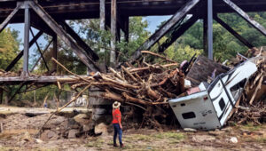
    Notre Dame de Paris, the French capital’s cathedral, has reopened its doors five years after a devastating fire, showcasing its restored interior after extensive rebuilding work. The restoration, costing approximately €700 million ($737 million), was financed entirely by donations from around the world.

    On April 15, 2019, Notre Dame tragically went up in flames, with the spire collapsing and the roof being destroyed. The following years were dedicated to rebuilding the cathedral, including the reconstruction of the spire and the restoration of stained glass and woodwork.

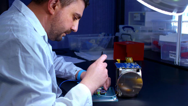
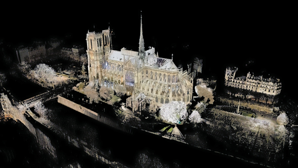
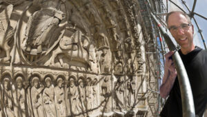
    A crucial element in the restoration process was the point cloud data collected by Professor Andrew Tallon, an architectural historian from Vassar College, in 2010. Tallon’s project, which aimed to fully understand the Gothic structure and identify structural anomalies, involved creating a precise 3D model of Notre Dame using a Leica Geosystems terrestrial laser scanner.

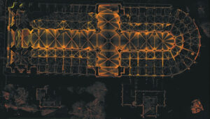
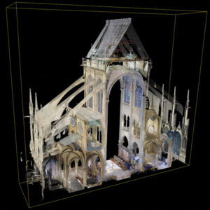
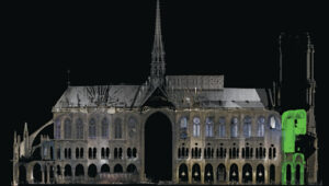
    This cloud of 1 billion points — with a TruView released by Leica Geosystems available to view here — proved to be indispensable for the digital recreation of the cathedral’s interior and exterior. Tallon’s laser scans were the only truly accurate as-built measurements of Notre Dame, translating point clouds into detailed representations of its buttresses, ribbed vaults, stained glass, ornate carvings and other architectural details.

    Tallon, who died of cancer in November 2018, pioneered the use of laser technology to create a digital model of Notre Dame. Members of the restoration team and architectural historian Lindsay S. Cook — assistant teaching professor of architectural history at Pennsylvania State University, and a protégé of Tallon’s — said his work was critical to the cathedral’s rebuilding and refurbishing.

    Tallon took some self-portraits as he mapped the cathedral. (Photo courtesy of the family of Andrew Tallon / Vassar College)
    Tallon took some self-portraits as he mapped the cathedral. (Photo courtesy of the family of Andrew Tallon / Vassar College)

    The value of point cloud data

    While modern restoration efforts cannot fully replicate the artistry of centuries past, Tallon’s scans have been instrumental in reconstructing the Gothic cathedral, allowing architects to come remarkably close. Tallon’s groundbreaking work remained a vital resource for restoring the iconic cathedral to this day.

    His meticulous 3D scans of Notre Dame provided architects with information crucial for the cathedral’s reconstruction, including:

    Precise 3D models: Tallon’s precise 3D model of Notre Dame included intricate details of the cathedral’s architecture, such as flying buttresses, rib vaults, stained glass windows and ornate carvings. This level of detail was unmatched by any historical drawings or records, which often lacked precision.

    Dimensional and formal reconstruction: Pascal Prunet, one of the architects tasked with rebuilding the cathedral, said in an interview with Lindsay S. Cook that the point cloud data provided an “exact trace” of the cathedral’s state at the time of scanning, allowing him and his team to reconstruct elements — such as the vaults — “without hesitation” regarding dimensions or forms. This was essential for accurately rebuilding complex structures such as flying buttresses and rib vaults.

    Structural analysis: The scans revealed structural details that were previously unknown, aiding in understanding how the cathedral was originally constructed and how it changed over time. This information was vital for designing custom supports and ensuring structural stability during reconstruction.

    Integration with modern technology: The point cloud data was integrated into Building Information Modeling (BIM) processes, which allowed architects to create a digital twin of Notre Dame.

    Restoration guidance: The scans provided a highly detailed record of Notre Dame’s pre-fire condition, which helped restoration professionals select appropriate techniques for stabilizing and rebuilding various parts of the cathedral.

    Tallon’s  laser scans provided the only accurate as-built measurments of Notre Dame de Paris, capturing detailed representations of its architectural features. (Photo: Andrew Tallon (Vassar College / Columbia University))
    Tallon’s laser scans provided the only accurate as-built measurments of Notre Dame de Paris, capturing detailed representations of its architectural features. (Photo: Andrew Tallon (Vassar College / Columbia University))

    Why precision matters

    On Oct. 25, 2023, Philippe Villeneuve, architect in chief of historical monuments in charge of Notre Dame, and Pascal Prunet, a fellow restoration architect, delivered a Claflin Lecture at Vassar College in New York. They discussed their efforts to shore up, conserve and restore the cathedral since the devastating fire.

    3D digital renderings were obtained from Tallon’s laser scans of Notre Dame Cathedral in Paris. (Photo: Andrew Tallon (Vassar College / Columbia University))
    3D digital renderings were obtained from Tallon’s laser scans of Notre Dame Cathedral in Paris. (Photo: Andrew Tallon (Vassar College / Columbia University))

    The two architects highlighted the crucial role Tallon’s laser scan of the cathedral played in their restoration process. They shared how this detailed digital model provided them with precise measurements and structural information, enabling Notre Dame to, in essence, “guide its own restoration.” By relying on this accurate data, the team could ensure its work remained faithful to the iconic cathedral’s original design and construction.

    When speaking with Cook, Prunet shared, “At Notre Dame, we are doing an enormous amount of work, but we are not doing creative work; we are putting things back together again.” Villeneuve added, “What we’re doing isn’t very personal.” Tallon’s laser scan has enabled the architects to allow Notre Dame to “speak for itself,” according to Villeneuve.

    Tallon had sent a copy of his point cloud to Villeneuve’s predecessor, Benjamin Mouton, before Mouton retired in 2013. After the 2019 fire, Marie Tallon saw that the architects had access to her late husband’s work. During their 2023 lecture and in a follow-up interview, Villeneuve and Prunet said Tallon’s scan — which Prunet called an “exact trace” of the state of the building at the time it was scanned — had been used in numerous ways since the fire.

    For example, it aided the design of the wooden centering custom-made to cradle each unique flying buttress and rib vault and to rebuild the damaged vaults and the sole transverse arch destroyed when the tip of the spire separated from its base and fell westward, becoming a projectile that crashed into the nave.

    The point cloud data was integrated into Building Information Models (BIM) processes, which allowed architechts to create a digital twin of the cathedral. (Photo: Andrew Tallon (Vassar College / Columbia University))
    The point cloud data was integrated into Building Information Models (BIM) processes, which allowed architechts to create a digital twin of the cathedral. (Photo: Andrew Tallon (Vassar College / Columbia University))

    “Andrew Tallon’s point cloud, well, it’s a bit like listening to a Mahler symphony,” said Prunet, alluding to the scan’s scale and complexity. Prunet continued, “It’s a recording,” but one that “needs to be decrypted.”

    Tallon’s laser scan of Notre Dame has proven invaluable in the restoration process. This digital twin, created in 2015, offers unparalleled precision and detail, capturing the cathedral’s every nuance with accuracy up to 5 mm. This level of detail allowed the restoration team to address the structure’s complexities and make informed decisions about the rebuilding process, ultimately helping to preserve Notre Dame’s authenticity and historical integrity.

  • Swift Navigation, Quectel partner for location-based products

    Swift Navigation, Quectel partner for location-based products

    Swift Navigation and Quectel Wireless Solutions have partnered to enhance GNSS accuracy across various industries. This collaboration integrates Swift’s Skylark Precise Positioning Service with Quectel’s high-precision GNSS modules.

    Skylark, a cloud-based GNSS corrections service, is designed to improve standard GNSS accuracy from several meters to a few centimeters. It utilizes advanced atmospheric modeling and a carrier-grade network to provide reliable, scalable, and high-integrity precision.

    The partnership offers three Skylark variants: Skylark Cx , Skylark Nx RTK and Skylark Dx.  Each variant is tailored to meet specific industry requirements and can be paired with Quectel’s GNSS modules for various applications.

    Integration and Applications

    Automotive: Quectel’s LG69T module with integrated inertial measurement units combined with Skylark Cx offers lane-level accuracy for intelligent driving systems.

    Outdoor Robotics: The LG290P module paired with Skylark Nx RTK offers centimeter-level accuracy for autonomous robots such as robotic lawnmowers.

    Micromobility: Quectel’s LC29H module with Skylark Dx achieves decimeter-level accuracy for e-bikes and scooters in urban areas.

    UAVs: The LG290P module with Skylark Nx RTK offers high accuracy for fast-moving UAV applications.

    Quectel’s LG290P is a quad-band GNSS module designed to deliver high performance for demanding applications, ensuring RTK availability and quality even in challenging environments. When paired with Skylark Nx RTK, the LG290P achieves the centimeter-level accuracy needed to ensure the precision required for applications such as precision agriculture, robotic lawnmowers, surveying and personal robots.

    The LC29H module is a dual-band multi-constellation solution with optional dead-reckoning capabilities that supports seamless integration with all Skylark variants and comes in a standard 12.2mm × 16.0mm footprint. Developers can transition from standard positioning to high-precision GNSS without hardware changes while choosing the Skylark variant that meets their specific requirements.

  • Voyant Photonics introduces Carbon lidar sensor

    Voyant Photonics introduces Carbon lidar sensor

    Voyant Photonics has introduced the Carbon frequency modulated continuous wave (FMCW) lidar sensor. It features lidar on a chip with solid-state beam steering integrated into a fingernail-sized silicon photonic chip. The Carbon sensor offers high-resolution imaging with millimeter precision and object detection capabilities up to 200 m.

     FMCW technology enables instant velocity measurement at each point, in addition to distance, reflectivity and intensity data. This 4D capability allows for high-fidelity point cloud data generation, providing a real-time view of the environment up to 20 times per second, according to Voyant Photonics.

    The sensor’s performance is notable in various environmental conditions. It can operate effectively through dust, fog, rain, and snow and is immune to sunlight interference, particularly during sunrise and sunset. Additionally, it is not affected by highly reflective objects such as street signs, traffic cones and safety vests.

    The Carbon sensor seeks to enhance machine perception capabilities across various industries, including industrial automation, robotics and security applications. Its software-defined lidar feature allows users to modify the frame rate and adjust the field of view during operation.

  • Lockheed Martin improves uncrewed capability for combat-proven HIMARS

    Lockheed Martin improves uncrewed capability for combat-proven HIMARS

    Lockheed Martin has demonstrated an uncrewed capability with a surrogate HIMARS launcher. On Dec. 4, 2024, the company showcased the launcher’s ability to navigate autonomously using non-emitting perception sensors, enabling seamless day and night operations without a human crew.

    This advancement marks a substantial step toward integrating autonomous solutions into the existing HIMARS fleet, supporting the U.S. Army’s modernization efforts for artillery capabilities. The technology offers enhanced adaptability in complex environments and aligns with Lockheed Martin’s 21st Century Security vision.

    The autonomous HIMARS system is designed to be easily integrated into existing platforms, maximizing the Army’s investment while retaining the option for crewed operations. This flexibility allows for adaptation to changing mission requirements and supports all-domain deterrence.

    Looking ahead, the Army envisions pairing manned HIMARS with autonomous wingman launchers for more efficient artillery operations. A follow-up demonstration is scheduled for the latter half of 2025.

  • u-blox unveils GNSS chip for wearable devices

    u-blox unveils GNSS chip for wearable devices

    u-blox has launched the UBX-M10150-CC, a GNSS chip designed for wearable devices. It offers advancements in size, power efficiency and performance for battery-powered devices.

    The chip measures 2.39 x 2.39 x 0.55 mm, making it suitable for integration into small wearable devices such as sports watches and smartwatches — it also includes a mode specifically designed for open water swimming. The UBX-M10150-CC utilizes low energy accurate positioning technology, which achieves power consumption as low as 10mW. This technology, combined with smart adaptation to signal conditions, allows for a 50% reduction in power consumption compared to previous M10 chips, according to u-blox.

    It incorporates multipath mitigation technology, which enhances position accuracy, particularly in urban environments where signal reflections are common. This feature can be beneficial for maintaining accurate tracking in challenging signal conditions, u-blox said.

  • NGS plans to release components of the modernized NSRS in 2025

    NGS plans to release components of the modernized NSRS in 2025

    Well, it’s January 2025 and it’s almost here — that is, the release of the beta version of the new, modernized National Spatial Reference System (NSRS) – NATRF2022, PATRF2022, CATRF2022, MATRF2022 and NAPGD2022.

    This newsletter will highlight some activities associated with the new NSRS. That said, this is short notice, but I would like to highlight that there is a webinar and workshop that will address the new NSRS scheduled for Jan. 9, 2025 — TRB workshop, “Navigating the Modernized National Spatial Reference System: A Geospatial Odyssey” and NGS webinar “Updates to Products and Models within the North American-Pacific Geopotential Datum of 2022.” I will provide more details on this later in the newsletter.

    First, on Oct. 9, 2024, NGS published a Federal Register that updated an implementation timeline for the modernized NSRS.

    Photo:
    Photo: NGS website

    The modernization of the NSRS is scheduled to occur in 2025 or 2026. NGS intends to release associated tools and services within five years of the modernization. The following details from the Federal Register outline the process for the rollout of the modernized NSRS:

    • NGS plans to roll out components of the modernized NSRS in 2025 or 2026. As each component is released at beta.ngs.noaa.gov, it can be publicly tested with feedback provided to NGS. The testing will continue for at least six months after the final component is released on beta.ngs.noaa.gov.
    • While the modernized NSRS is being rolled out and tested, the current NSRS will remain the official NSRS of the United States. The official NSRS (i.e., currently NAD 83, NAVD 88, etc.) may be found at geodesy.noaa.gov. Only one major improvement to the current NSRS is expected during this time: ITRF2020 will be integrated in all products and services.
    • Once testing is complete and all modernized NSRS components appear to be stable and correct, the Federal Geodetic Control Subcommittee (FGCS) will be asked to vote to approve the modernized NSRS (likely in 2026). If FGCS approves the modernized NSRS, NGS will publish an FRN announcing the approval of the modernized NSRS and begin a several-month process of transitioning all modernized NSRS components to the official website at geodesy.noaa.gov. During this transition, the beta website may be wiped of submitted data and no further submissions to the NGS IDB (the repository for the current NSRS) will be allowed.
    Excerpt from Federal Register Notice. (Photo: Federal Register website)
    Excerpt from Federal Register Notice. (Photo: Federal Register website)

    What does “Only one major improvement to the current NSRS is expected during this time: ITRF2020 will be integrated in all products and services” mean? I understand that one product that ITRF 2020 will be integrated into is the NOAA CORS Network (NCN). The CORS coordinates and velocities will be updated with ITRF 2020 values. That said, NGS datasheets will still provide coordinates in NAD 83 (2011), epoch 2010.0.

    As I’ve mentioned in previous newsletters, time really is running out and users need to obtain a working knowledge of the new, modernized National Spatial Reference System. For those attending the 104th TRB Annual Meeting on Jan. 5-9, 2025, in Washington, D.C., there is a scheduled workshop on the modernized NSRS. The workshop is sponsored by TRB Geospatial Data Acquisition Technologies Committee (AKD70). The workshop, titled “Navigating the Modernized National Spatial Reference System: A Geospatial Odyssey,” will be held on Thursday, Jan. 9, 2025, from 9:00 am to noon, in room 202B in the Convention Center in Washington, D.C.


    Navigating the Modernized National Spatial Reference System: A Geospatial Odyssey

    Thurs., Jan. 9, 2025
    9:00 am to 12:00 pm
    Room 202B, Convention Center
    Washington, D.C.

    This workshop will cover the following topics: 

    • Why the NSRS is being updated
    • The key goals of the modernization effort
    • Timeline, standards and technology considerations
    • The Geospatial Data Act of 2018 and its impact
    • There will be a discussion about the replacement of the North American Datum of 1983 and vertical datums and implications for existing workflows
    • There will also be a discussion about use cases and practical scenarios, how to transition and how to leverage new technology and tools.

    For those interested in more information on the TRB AKD70 committee, my August 2024 GPS World Newsletter highlighted activities associated with the Transportation Research Board’s ADK70 Standing Committee on Geospatial Data Acquisition Technologies.

    Since the new NSRS will be introduced this year, it is time for users of the NSRS to get familiar with the NOAA Technical Memorandum NOS NGS 92 document titled “Classifications, Standards and Specifications for GNSS Geodetic Control Surveys using OPUS Projects” written by  Dave Zenk and Dan Gillins, Ph.D., National Geodetic Survey, published on Oct. 23, 2024. This document provides the specifications users must adhere to when submitting GNSS projects to NGS for review and publication.

    Photo: NGS website
    Photo: NGS website

    The section below explains the purpose of the document. There are a few items that I have highlighted in the preface that users should be aware of:

    • The document replaces NOAA Technical Memorandum NOS NGS 58 and NOAA Technical Memorandum NOS NGS 59
    • Users will need to follow these specifications for all projects that will be submitted to NGS using OPUS Projects for review and publication
    • It is specifically limited to supporting NGS’s OPUS Projects Web-Based Tool.

    Preface

    This publication supplements Standards and Specifications for Geodetic Control Networks issued in September 1984 (Bossler 1984).

    This publication replaces NOAA Technical Memorandum NOS NGS 58 Guidelines for Establishing GPS-Derived Ellipsoid Heights (Standards: 2 cm and 5 cm), Version 4.3 (Zilkoski et al. 1997) and also replaces NOAA Technical Memorandum NOS NGS 59 Guidelines for Establishing GPS-Derived Orthometric Heights (Zilkoski et al. 2008).

    This publication provides classification, standards, and specifications for GNSS geodetic control surveys that use Global Navigation Satellite Systems (GNSS)which will be submitted to NGS using OPUS Projects for review and publication. These types of surveys were not well-established by the dates of the 1984, 1997, and 2008 publications, nor did OPUS Projects exist. In addition, since 2008 GNSS technology has improved and considerable research has been done into the best practices regarding these surveys and the analyses of achievable results (e.g., Allahyari et al. 2018; El Shouny and Miky 2019; Gillins and Eddy 2015, 2017; Gillins et al. 2019a; Gillins et al. 2019b; Jamieson and Gillins 2018; Park et al. 2018; Schenewerk et al. 2016; Soler and Wang 2016; Wang and Soler 2013; Wang et al. 2017; Weaver et al. 2018). That research supports this publication.

    This publication is specifically limited to supporting OPUS Projects (version 5.x), the current North American Datum of 1983 (NAD 83), the North American Vertical Datum of 1988 (NAVD 88) and other current vertical datums that are officially recognized by NGS. Future versions of OPUS Projects and future datums will require revision of this publication.


    For those that want to know more about the document, the National Geodetic Survey (NGS) held a webinar that described the classifications, accuracy standards and general specifications for GNSS geodetic control surveys using OPUS Projects on April 13, 2023. The webinar provided a summary of the NOAA Technical Memorandum NOS NGS 92 document. NGS presentations and webinars can be downloaded at the following websites: https://geodesy.noaa.gov/web/science_edu/presentations_library/, https://geodesy.noaa.gov/web/science_edu/webinar_series/2023-webinars.shtml, and https://geodesy.noaa.gov/web/science_edu/webinar_series/standards-specs-opus-projects.shtml.

    I highlighted some important sections of the April 2023 webinar in my May 2023 newsletter. Future newsletters will address the specifications in more detail, but I would encourage readers to download the NGS 92 document and the April 13 webinar and slides.

    On Dec. 18, 2024, NGS sent an email to individuals on NGS’s listserv informing them that they have made several updates to the NAPGD2022 products and that these updates are now available on the NGS alpha site.

    NGS Dec. 18 newsletter. (Photo: NGS website)
    NGS Dec. 18 newsletter. (Photo: NGS website)

    To explain the product updates, NGS has scheduled a webinar for Jan. 9, 2025, to discuss the North American-Pacific Geopotential Datum of 2022 (NAPGD2022).

    I highlighted the NGS Alpha site and GEOID2022 — a product of the NAPGD2022 — in my July 2024 newsletter. I did a 4-part series in my GPS World newsletters in 2017 on the products of NAPGD2022 (June 2017, August 2017, October 2017, and December 2017). I would encourage everyone to register for the webinar.

    NGS webinar on NAPGD2022. (Photo: NGS website)
    NGS webinar on NAPGD2022. (Photo: NGS website)

    As previously stated in my newsletters, users should obtain a working knowledge of the new, modernized National Spatial Reference System. NGS publicly given presentations that have been collected for public viewing can be downloaded here.

    I would like to wish everyone a Happy New Year and a year filled with exciting opportunities.

  • ESA releases plans for FutureNAV Industry Day 2025

    ESA releases plans for FutureNAV Industry Day 2025

    The European Space Agency (ESA) will host the first FutureNAV Industry Day on Feb. 18, 2025 — at ESTEC, the Netherlands — to address the growing demand for advanced positioning, navigation and timing (PNT) technologies. This event aims to bring together European stakeholders in satellite navigation to discuss future developments and foster collaboration within PNT and GNSS sectors.

    As the leading system developer and design authority for Galileo and EGNOS, ESA plays a crucial role in Europe’s satellite navigation landscape. The agency launched the FutureNAV program in 2022 to unify efforts in advancing navigation technologies. Two key missions under this initiative are low-Earth orbit (LEO) PNT, which will demonstrate the potential of navigation satellites in LEO and Genesis, which will combine four geodetic techniques in one satellite to improve Earth’s reference frame.

    FutureNAV Industry Day seeks to provide attendees with insights into ESA navigation plans and potential opportunities for European industry. It will follow a Request for Information on LEO-PNT industrialization, gathering information on European production capabilities for payload building blocks and satellite platforms.

    To complement these upstream initiatives, the Navigation Innovation and Support Programme (NAVISP) Industry Days will be held at the University of London on March 4-5, 2025, focusing on downstream applications and bringing together industry leaders and innovators.

    Click here to register and learn more about the event.

  • Overture Maps Foundation launches transportation dataset

    Overture Maps Foundation launches transportation dataset

    The Overture Maps Foundation has released the general availability of its global transportation dataset. This dataset encompasses 86 million km of roads worldwide and is designed to support various industries, including automotive, logistics, navigation, urban planning and humanitarian response.

    The transportation dataset incorporates detailed information from multiple sources:

    • Aerial imagery for accurate road representations
    • Clear road routes with recognizable highway signs
    • Comprehensive rail and ferry route information
    • Complex traffic rules and restrictions

    Building upon OpenStreetMap data, Overture has re-engineered the data structure to create a more stable dataset with a documented schema, the company said.

    Data enhancements

    Overture has implemented several improvements to the OSM data, including:

    Normalization: The dataset adheres to a standard set of attributes, ensuring uniformity across features such as right turns and speed limits. This seeks to facilitate simplified analysis, interpretation and use of the data.

    Global Entity Reference System (GERS): Overture has introduced unique identifiers through a linear reference system. This allows users to attach external data, such as accident reports or road construction updates, to specific road segments with precise location information.

    According to Overture, the transportation dataset will undergo continuous updates and improvements. Future enhancements will leverage artificial intelligence and other open data sources to maintain and expand the dataset’s accuracy and completeness.

  • Seen & Heard: Self-driving cars get smarter, Antarctic Peninsula turns green and more

    Seen & Heard: Self-driving cars get smarter, Antarctic Peninsula turns green and more

    “Seen & Heard” is a monthly feature of GPS World magazine, traveling the world to capture interesting and unusual news stories involving the GNSS/PNT industry.


    Smarter self-driving cars

    Photo: hoi dongsu / iStock / Getty Images Plus / Getty Images
    Photo: hoi dongsu / iStock / Getty Images Plus / Getty Images

    Researchers at Drexel University have developed a testing method to enhance the robustness of autonomous driving systems. Their approach uses dynamic visual patterns to evaluate object detection capabilities in self-driving cars, focusing on critical objects such as traffic signs. A “Screen Image Transformation Network” (SIT-Net) simulates real-world image capture scenarios affected by environmental factors. By identifying weaknesses in autonomous vehicle perception systems, the researchers aim to improve safety and reliability in future self-driving technologies.

    Robo-dog gets an upgrade

    Photo: Boston Dynamics / Leica Geosystem
    Photo: Boston Dynamics / Leica Geosystem

    The Leica BLK ARC autonomous laser scanning module has become the first certified reality capture device capable of being fitted to Boston Dynamics’ robotic dog, Spot. The BLK ARC, when mounted on Spot, is designed for fully autonomous and repeatable scan missions. Users can plan scan paths remotely using existing drawings or BIM models, allowing the robot to navigate and capture data with minimal human intervention. Spot features a 360° vertical and 270° horizontal field of view, with a scan range of up to 25m.

    USGS aids recovery after Hurricane Helene

    Photo: Logan Combs, USGS
    Photo: Logan Combs, USGS

    The U.S. Geological Survey (USGS) is actively aiding recovery efforts following Hurricane Helene by collecting flood data, repairing damaged stream gages and analyzing new flood records. The agency has deployed its landslide event team to assess and document landslide impacts, conduct aerial surveys and map affected areas. By collaborating with local, state and federal agencies, the USGS is providing critical data and expertise to support disaster response and recovery efforts.

    Antarctic Peninsula turns green

    Photo: Tom Roland
    Photo: Tom Roland

    Satellite imagery revealed that the Antarctic Peninsula is experiencing a dramatic increase in vegetation, with plant coverage expanding from less than 1 km² in 1986 to nearly 12 km² by 2021. This trend has accelerated significantly, coinciding with extreme heat events and record glacier melting linked to climate change. The study, conducted by researchers from the Universities of Exeter and Hertfordshire and the British Antarctic Survey, indicates that warmer temperatures and increased precipitation create favorable conditions for mosses, which dominate the newly vegetated areas.

  • Burro and GEODNET partner to boost agricultural robotics with RTK GPS

    Burro and GEODNET partner to boost agricultural robotics with RTK GPS

    Burro, an agricultural robotics provider, and GEODNET, a blockchain company providing precise GPS positioning solutions, have entered a strategic partnership to integrate GEODNET’s real-time kinematic (RTK) GPS technology into Burro’s autonomous robots.

    Burro’s autonomous robots are designed for material transport in various agricultural settings, including nurseries, fields and farms. These robots utilize advanced artificial intelligence, computer vision and lidar technology to perform tasks with high precision. Integrating GEODNET’s RTK GPS technology seeks to significantly improve the robots’ navigation accuracy and operational efficiency, particularly in areas where reliable GPS coverage is crucial.

    RTK can provide centimeter-level precision, compared to the 2 m to 4 m accuracy of traditional GPS systems, GEODNET said. The increased precision reduces overlap in field operations, minimizing fuel usage and time required to complete tasks. Precise positioning enables more accurate application of seeds, fertilizers and pesticides, reducing waste and improving crop yields.

    The partnership between Burro and GEODNET will allow for the provision of RTK corrections and base stations to Burro’s robots. This capability is particularly valuable in regions with limited GPS coverage. The ability to rapidly deploy new base stations offers increased flexibility for users, allowing them to expand their operations quickly and efficiently.

  • Advanced Navigation partners with Rheinmetall Defense Australia to deliver inertial navigation solutions for combat vehicles

    Advanced Navigation partners with Rheinmetall Defense Australia to deliver inertial navigation solutions for combat vehicles

    Advanced Navigation has finalized a multi-million dollar deal with Rheinmetall Defense Australia to provide fiber-optic gyroscope (FOG) inertial navigation systems (INS) for integration into Rheinmetall’s Boxer Combat Reconnaissance Vehicles (CRV), currently deployed by the Australian Army.

    This agreement builds upon a previous collaboration in 2021, where Advanced Navigation supplied over 200 FOG INS units for the Boxer CRV as part of the LAND 400 Phase 2 Program.

    Arming the Boxer CRV with FOG INS technology

    The FOG INS technology developed by Advanced Navigation incorporates sophisticated algorithmic capabilities, resulting in a compact yet powerful navigation solution that outperforms traditional filter-based systems.

    The system incorporates Advanced Navigation’s algorithmic technology, enabling the FOG INS to provide navigation data that surpasses outputs based on traditional filter methods while maintaining a compact form factor. The optical gyroscope’s design, free from moving parts, ensures exceptional resilience against shock and vibration-induced errors – a crucial feature for vehicles traversing challenging terrains.

    Validated in real-world operations, the FOG INS integrated into the Boxer CRV, an armored 8×8 vehicle, offers enhanced troop safety, security and protection, coupled with high levels of firepower and mobility for sustained operations ranging from peacekeeping to high-intensity combat. The Boxer CRV is equipped with a reconnaissance mission module, including the two-person digital Lance turret, the first crewed medium-caliber turret to be put into service on the Boxer platform.

    This partnership between Rheinmetall and Advanced Navigation aligns with the objectives of the Australian Defense Global Supply Chain (GSC) Program, aimed at expanding opportunities for Australian suppliers and boosting export prospects within the global defense industry.

  • SpaceX launches GPS III satellite for US Space Force

    SpaceX launches GPS III satellite for US Space Force

    Following weather delays, the U.S. Space Force’s Space Systems Command (SSC) and Space Operations Command expedited the Rapid Response Trailblazer launch schedule to fulfill a specific warfighter requirement. On Dec. 16, 2024, SpaceX’s Falcon 9 rocket launched the GPS III SV-07 satellite from Space Launch Complex 40 at Cape Canaveral Space Force Station, Florida.

    For the mission, multiple Space Force organizations collaborated to retrieve an existing GPS III satellite from storage, expedite integration and launch vehicle preparation, which was quickly processed for launch. The success of the launch proved a two-fold concept of operations. SSC’s Assured Access to Space showcased its agility in partnering with industry to meet evolving national needs, completing a National Security Space class launch in less than five months.

    This marks the first Space Operations Command mission led by Mission Delta 31 for a Space Vehicle launch, and it demonstrated exceptional flexibility by reducing the typical six-month pre-launch processing timeline to approximately three months, Space Operations Command said. This effort involved close coordination with Lockheed Martin in Colorado to rapidly prepare SV-07 for launch.

    The GPS III SV-07 satellite joins a robust constellation comprising 31 active vehicles, seven in reserve status and three completed GPS III vehicles awaiting launch. Equipped with M-Code technology, these satellites offer improved anti-jamming and anti-spoofing capabilities, enhancing secure access to military GPS signals for U.S. and allied forces.