Author: Maddie Saines

  • Septentrio hosts webinar on the impact of spoofing on UAV autopilots

    Septentrio hosts webinar on the impact of spoofing on UAV autopilots

    Photo:
    Image: Septentrio

    As drones are becoming a popular mode of delivery, surveillance, inspection, and mapping, they need to be resilient to spoofing. On Dec. 15, Septentrio hosted a webinar about detecting, mitigating, and protecting against spoofing on UAV autopilots.

    Topics discussed included how GPS/GNSS technology fit into the autopilot ecosystem, signs of GPS spoofing and UAV vulnerabilities, realistic demonstrations of spoofing, how to mitigate spoofing, and autopilot compatibility with resilient GPS modules.

    Wim De Wilde, R&D Team Leader at Septentrio, facilitated a presentation on vulnerabilities of UAVs. It included detecting signal anomalies and inconsistencies in GPS receivers to flag spoofing, technology used to spoof or hijack drones, and recommendations to prepare autopilots before take-off.

    The next presentation, by Ramon Roche, General Manager at DroneCode Foundation and PX4 Autopilot, explained PX4 products that have built-in resilient GPS receivers. Greg Lopes, Hardware Design Engineer at Zipline, further elaborated about the importance of having robust, resilient GPS receivers to mitigate spoofing as it relates to Zipline’s delivery drones.

    Photo:
    Figure 1

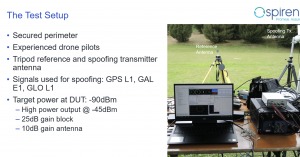
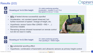
    One of the final presentations was a case study of an in-field simulation and spoofing test by Jack Ackermann, Director of Product Line Management at Spirent. The case study preparation and test results that were discussed in the webinar can be seen in Figures 1 and 2.

    Septentrio holds frequent webinars, with knowledgeable guest speakers, regarding topics related to GPS/GNSS technology. Find previous webinars and learn about upcoming ones here.

    Photo:
    Figure 2
  • M3 Systems Belgium uses HAPS to improve Cospas-Sarsat

    M3 Systems Belgium uses HAPS to improve Cospas-Sarsat

    M3 Systems Belgium’s Haps-Augmented Search-And-Rescue Demonstrations System (HASARDS) project is looking to improve positioning of the global collaborative Copas-Sarsat search-and-rescue system by using its high-altitude platform system (HAPS).

    The project is designing features for the system, such as carrying out geolocation with HAPS imagery and establishing communication between individuals in distress and emergency services.

    While conducting HASARD, researchers were able to document system enhancements, execute a piloted flight-test campaign to create a realistic distressed aircraft carrying a second-generation beacon and future HAPS, and develop and operate a second-generation beacon signal simulator and HAPS system simulator.

    Researchers found that using HAPS independent of Cospas-Sarsat adds value to search-and-rescue operations, providing location details via data fusion and georeferenced imagery while relaying communication between SAR teams and people in distress.

    Photo: M3 Systems Belgium
    Photo: M3 Systems Belgium
  • 2023 European Navigation Conference scheduled for May/June

    2023 European Navigation Conference scheduled for May/June

    The 2023 European Navigation Conference (ENC) will take place May 31-June 2 with a focus on resilient navigation. This conference, which will welcome professionals from the positioning, navigation, and timing (PNT) field, is organized by the Netherlands Institute of Navigation, a member of the European Group of Institutes of Navigation (EUGIN).

    Given the growing vulnerability of satellite-based position and timing, the conference will focus on resiliency, which requires redundancy in the signal domain, terrestrial and space infrastructures, and on-board implementation — as well as addressing vulnerabilities in navigation functions, data, and guidance control.

    Thanks to the hospitality of the European Space Agency, the ENC will be held at the ESTEC site in Noordwijk, The Netherlands, where the Galileo satellite system is designed and where navigation satellites are tested before launching.

    Photo: extravagantni/iStock/Getty Images Plus/Getty Images
    Photo: extravagantni/iStock/Getty Images Plus/Getty Images
  • Remote carrier flight test demonstrator successfully launched

    Remote carrier flight test demonstrator successfully launched

    Germany has successfully launched the Future Combat Air System (FCAS) Remote Carrier demonstrator, released by an A400M.

    The launch was carried out by the Bundeswehr Technical Center for Aircraft and Aeronautical Equipment (BAAINBw) and the German Aerospace Center (DLR), with collaboration from Airbus and German companies SFL and Geradts.The Remote Carrier demonstrator — an altered Airbus Do-DT25 drone — was launched from a device created specifically for the A400M to release remote carriers.

    After the remote carrier was launched, its Do-DT25 engines were ignited, and it continued to fly. Controls from the A400M were then handed to the ground operator who landed the drone successfully.

    As a part of the launch, the A400M was also evaluated to determine its role in FCAS to serve as a UAV launcher. Because the launch results were successful, Airbus is aiming to have the multi-role air lifter serve as the host of remote carriers.

    The remote carriers and A400Ms will have an integral role in expanding the use of unmanned systems by Airbus’s military transport aircraft in the FCAS.

    Photo: Airbus
    Photo: Airbus
  • Self-driving cars: Innovative or a nuisance?

    Self-driving cars: Innovative or a nuisance?

    Photo:
    Image: iStock/Getty Images Plus/Getty Images

    San Francisco local officials are questioning the safety of autonomous vehicles (AV), also known as self-driving cars, due to frequent reports of traffic violations, delaying public transportation and emergency vehicles, causing traffic congestion as well as driving onto public sidewalks.

    California officials granted the first AV deployment permits this year, allowing companies to release self-driving cars onto city streets and to provide passenger service as robotaxis. Since granting permits to AV companies such as Waymo and Cruise, self-driving vehicles have been creating a multitude of issues with public safety, including a recent incident of a Cruise AV stopping a bus on its route for over seven minutes.

    As state governments have the legal power to grant permits to AV companies to conduct testing and ride hail services, city officials are left powerless to control self-driving car incidents that affect residents and public safety. City officials also struggle to obtain information regarding AV-induced road blockages and even a comprehensive list of all companies have deployed self-driving vehicles onto their roads.

  • Biden administration pushing for streamlined space rules

    Biden administration pushing for streamlined space rules

    Photo:
    Image: Blue Origin

    The White House is drafting an executive order that would simplify the approval for private launches by clarifying space rules and regulations for private American space companies. This order, which President Biden could sign into law early next year, aims to simplify licensing procedures in accordance with existing federal space laws to routinize space activities, including launching rockets and satellites deployed by private companies. Private space companies such as Elon Musk’s SpaceX and Jeff Bezos’ Blue Origin, are preparing to invest in several projects over the next decade, such as Blue Origin’s Orbital Reef project, which would build a commercial space station in low-Earth orbit (LEO).

    Additionally, an online tool is being designed for the Department of Commerce to guide private companies through the licensing requirements from the relevant federal agencies. The order may also include granting certain federal agencies oversight of space activities that are not currently monitored, such as asteroid mining and space junk removal.

  • Spirent to host two federal training seminars in 2023

    Spirent to host two federal training seminars in 2023

    Photo:
    Image: Spirent

    Spirent plans to host two seminars in early 2023 where experts will share PNT developments and provide training on Spirent’s products. Registration for the seminars is free and includes a two-week software license that can be downloaded to provide hands-on training.

    Seminar training topics includes fundamentals of GPS/GNSS testing, how to create realistic testing scenarios, GPS/GNSS vulnerabilities like jamming and spoofing, vulnerability mitigation and more.

    One session will be held in Huntsville, Alabama, March 8-9 and the other in Los Angeles, California, March 14-15. While registration is free, seats at both seminars are limited.

    To register for Spirent’s seminars, click here.

  • Apple sued for privacy concerns regarding Apple AirTags

    Apple sued for privacy concerns regarding Apple AirTags

    Photo: Apple
    Photo: Apple

    Two women have filed a class-action lawsuit against Apple for privacy concerns as Apple AirTags are being widely used for malicious and criminal purposes.

    Both women and their families were tracked and stalked by ex-partners using Apple AirTags hidden in their personal belongings. They are now suing Apple for negligence and privacy violations stating the company failed to protect its customers. They are both seeking damages and are hoping to prevent Apple from continuing to manufacture this product with “design flaws.”

    The location device was designed by Apple in 2021 and its intent is to be attached to such items as keys, suitcases and purses to make them trackable. However, the $29 Bluetooth-enabled AirTags can be used as a weapon by abusers, stalkers and traffickers to easily find and track their victims.

  • Satellite observation is helping to map lava from Hawaii’s Mauna Loa volcano

    Satellite observation is helping to map lava from Hawaii’s Mauna Loa volcano

    Image: USGS
    Image: USGS

    In late November, the Mauna Loa volcano in Hawaii erupted for the first time since 1984 and is currently in an active volcanic eruption. Scientists are using satellites and helicopters to record and map the flow of lava on the Big Island.

    The active eruption is in a remote area on the island, making it difficult to map it and the lava flow. It is critical to have accurate emergency information during the eruption in order to have appropriate resources and have ample time to evacuate, if necessary.

    The easiest and most accurate way to map the lava from this eruption is via satellite. Based on satellite observation, scientists have been able to create a mobile app to support helicopter crews in making maps of lava flow that update in real time. This real time evaluation is sent to emergency personnel and geologists tracking the eruption patterns.


    Photo:
    Image: USGS

    Mauna Loa has erupted 33 times, the most recent of which was 38 years ago. The volcano typically averages an eruption every 5 years, making Mauna Loa’s most recent dormant period longer than normal. According to the U.S. Geological Survey (USGS), this eruption was caused by an increase in earthquakes below the Mauna Loa Summit, an increase of inflation tracked by GPS stations, and several additional geologic factors.

    Live footage of the Mauna Loa eruption can be seen here.

  • EGNOS upgrades to level up user experience

    EGNOS upgrades to level up user experience

    Image: EUSPA
    Image: EUSPA

    Europe’s regional satellite-based augmentation system (SBAS), EGNOS, has received upgrades to advance the reliability of GNSS positioning information, according to EUSPA.

    Historically, EGNOS has provided safe, uninterrupted satellite navigation services to aviators, and some maritime, railroad, and land-based users in Europe. This system upgrade includes extending its service area, adding advanced functionalities, and reinforcing dual-frequency and multi-constellation services.

    The EGNOS V242B system upgrade will expand services outside of its service area and enhance availability to users. Additionally, the upgrade ensures aviator access to lifesaving services such as Localizer Performance with Vertical Guidance (LPV)-200. The upgrade also includes more advanced data processing functions to cater to increased issues with peak solar activity and ionospheric phenomena that interfere with EGNOS signals and services.

    Dual-frequency and multi-constellation services were also improved in the EGNOS upgrade. The improvements revamped EGNOS Version 2, and reinforced EGNOS services before launching EGNOS Version 3 (V3).

    EGNOS delivers two frequencies and has amplified Galileo signals, hence creating a multi-constellation capability. When EGNOS V3 is launched, it will offer additional services and enhance protection against cyberattacks, further advancing EGNOS’ safety-critical applications across Europe.

  • SpaceX begins partner project designed for national security

    SpaceX begins partner project designed for national security

    Photo:
    Image: 3DSculptor/iStock/Getty Images Plus/Getty Images

    The private spaceflight company, SpaceX, has undertaken a partner project in addition to its existing space efforts ranging from sending satellites and people to space, to providing a brand of commercial internet connection to remote areas.

    The new partner project, Starshield, will join Starlink in providing secure, broadband internet connection to customers. However, there is a stark difference between the partner projects.

    Starlink technology has end-to-end user data encryption to secure its network as it was designed for commercial customers. However, the Starshield project is intended for government use in national security efforts. Therefore, it is equipped with an additional high-assurance cryptographic feature to host payloads and process data in a secure way aligning with government national security requirements.

    As reported by SpaceX, Starshield has three focus areas including: Earth observation, global communications, and hosted payloads. Starshield’s satellites can integrate with a variety of different payloads and the constellation has a low-Earth orbit (LEO) design making it robust to on-orbit assets.

    SpaceX continues to work closely with the United States Department of Defense by providing innovative space technology.

  • Mapbox product updates designed to enhance location technology

    Mapbox product updates designed to enhance location technology

    Mapbox, a maps and location platform, has created new products and platform updates to aid developers in making more accurate, data-driven decisions and improving overall user experience with advancement in location technology.

    Navigation SDK v2.9 was introduced to provide pre-built navigation applications, compatible with Android and IOS, which will provide all the primary navigation components across a workflow using lines of code instead of starting from square one. The Drop-in UI is customizable to create applications that reflect a developer’s brand, rather than needing to manually develop a full end-to-end application.

    Photo:
    Image: Mapbox

    Navigation SDK Copilot, a backend analytics tool for CX on navigation applications, was launched and designed by Mapbox to collect trace files of navigation sessions and search analytics data from users. Developers can use this data to gather feedback and collective user data to create touch points with users and improve application experience based on their data-drawn conclusions.

    Mapbox’s platform updates and product innovation also include improvements to its Matrix API, which can now support scheduled departure times and provide optimal driving routes creating a more accurate ETA. This innovative location technology is also designed to enhance fuel efficiency and decrease emissions.

    Photo:
    Image: Mapbox

    As map boundaries are constantly changing, Mapbox has expanded its visualization of map lines to update as frequently as the lines change. The expanded visualization makes updates quicker and improves the ability of Mapbox’s platform to give users the most up-to-date information.