On Dec. 20, u-blox banned the use of its GNSS modules in military UAVs in the war between Russia and Ukraine. The company had become aware that its GNSS modules were being used in certain Russian reconnaissance UAVs and stated that this use was against company policy.
U-blox obtained media reports that Russia had stocked up on components in anticipation of war, then integrated products from the company in UAVs it manufactured after attacking Ukraine.
After Russia began its invasion of Ukraine, the company halted all sales to Russia, Russian territories, and Russian-occupied areas, as it intends its GNSS modules and other products to be used only commercially. U-blox company policy bans the use of its products in weapons, including systems for target identification.
U-blox is investigating the infringement of its policy and plans to take legal action if it has been violated. The company also condemns the invasion of Ukraine by Russian forces.
On Dec. 22, Hexagon AB announced its acquisition of LocLab, a German company that specializes in 3D digital twin content creation. LocLab will operate as a part of Hexagon’s Geosystems division.
This acquisition, which began as a partnership, strengthens Hexagon’s ability to make its Smart Digital Reality, a 3D hub for data management and information, more accessible to new and existing users while giving LocLab’s users a platform to host, share and keep 3D digital twins up to date.
LocLab’s toolchain leverages several data input formats such as terrestrial videogrammetry, survey data and point clouds, but only requires photos or videos. Hexagon is integrating LocLab’s 3D digital content with its HxDR cloud-based storage, visualization, and collaboration platform. This integration drives HxDR’s expansion as a digital reality platform into the transportation, construction and urban planning industries.
The integration of HxDR and LocLab’s capabilities strengthens Hexagon’s reality capture and software portfolio while offering LocLab global scalability opportunities through Hexagon’s sales and partner network.
On Dec. 20, the Linux Foundation announced its AgStack Project, which will host an open-source code base, along with a fully automated, continuous computation engine that will maintain a global dataset of boundaries for agricultural fields. The AgStack Asset Registry dataset will aid food traceability, carbon tracking, crop production, and other field-level analytics.
This ‘registry’ is designed to continuously update using data from satellites and real field registrations that contain boundary information, which will train machine learning models to ascertain more boundaries, among other capabilities.
Agricultural datasets are rarely public information. By using computer science and artificial intelligence (AI), users can create global field boundaries as a digital open source for public use, which can help farmers, agricultural companies, and the public manage crop production, study management practices, assess levels of productivity, monitor the spread of pests and diseases and more.
The AgStack project seeks to enable all types of agricultural data and services by combining computing and AI expertise with a global network of partners in an open-source software system. All code is being contributed under an open-source license and will be governed by the AgStack community, within the Linux Foundation.
Point One’s FusionEngine software, which is rated for automotive safety integrity level (ASIL), is now compatible with STMicroelectronics’ Teseo ASIL Precise Positioning GNSS chipset (TeseoAPP). This assures functional safety as ASIL-B, a requirement for Level 3+ advanced driver assistance systems (ADAS).
FusionEngine can be integrated into several different host processors that are used for enabling high level ADAS and autonomous driving systems. The combination of TeseoAPP’s receiver and the STA5365S external RF front-end provides dual-band measurement data for all visible GNSS satellites to the main host processor into which FusionEngine is integrated.
FusionEngine software is a precise location solution for automotive applications. For accuracy and to ensure the safety and integrity required for high level autonomous vehicles it combines data from multiple sensors, including the TeseoAPP multi-band GNSS receiver. It also enables developers to complete the functional safety concept phase for host system software integration.
On Dec. 20, Hexagon announced a partnership to integrate its software positioning engine and correction services with ZF Group’s ProConnect connectivity platform. This will enable vehicle communication in advanced driver assistance systems (ADAS) and autonomous driving systems.
This integration is critical to providing the necessary functional safety, lane-level positioning accuracy and automotive safety integrity level (ASIL) rating that ZF’s automotive telematics platform requires. Hexagon’s TerraStar-X precise point positioning correction service will greatly improve the accuracy and reliability of ADAS and autonomous driving systems.
Hexagons’ dual frequency and multi-constellation GNSS receivers are tightly coupled with inertial capabilities that withstand vehicle dynamics in all driving conditions.
Both companies are focused on the next generation of mobility, including electric vehicles and autonomous systems, and this partnership helps advance safety and automation in the automotive and transportation industry. Hexagon and ZF plan to demonstrate their ADAS at the Consumer Electronics Show in Las Vegas in January 2023.
On Nov. 18, the European Space Agency (ESA) announced a Navigation Innovation and Support Programme (NAVISP) partnership with Italy’s Grimaldi Group, as the need for accurate maritime navigation increases. With the Grimaldi Group, NAVISP has taken on the Grimaldi Satellite-Assisted Berthing (GSAB) project, which aims to develop a satellite-based guidance system for docking maneuvers of large vessels.
NAVISP’s GSAB project will use satellite-based multi-sensor technology to improve the efficiency of maneuvers in ports to increase safety while also reducing CO2 emissions. Maritime navigation is too complex for GPS and Galileo alone, so, by fusing those two systems with PNT sensors, the project can achieve its intended outcome.
The project is divided into two phases. In the first phase, NAVISP is working on design, development activities, installation of the sensors in a roll-on, roll-off vessel, and running a test readiness campaign. The second phase includes field tests with the equipped ship in the Grimaldi facilities in the Port of Antwerp-Bruges, Europe’s second largest seaport.
Shipping transport is responsible for more than 80% of goods traded globally, and the Grimaldi Group is one of the largest shipping companies globally with more than 130 ships. As the need for efficient and safe ship transport in and out of ports grows, NAVISP continues to support innovation to improve satellite navigation and positioning systems in the maritime sector, according to ESA.
Bikes have been used for centuries for transportation, exercise, and recreation. Now, thanks to developments in battery technology and growing environmental concerns, sales of e-bikes are exploding.
The Roundup has estimated that 300 million e-bikes will be used around the globe by next year, with annual sales reaching 10 million by 2024 and 17 million by 2030.
Mapbox, a platform that provides maps and location data for developers and works with such notable companies as Strava, General Motors, and Instacart, offers micro mobility solutions to help e-bike companies develop advanced navigation systems. E-bike maker Cowboy, and shared micro-mobility operator TIER Mobility, use Mapbox for their customizable navigation technology that provides turn-by-turn navigation with voice guidance, route optimization, traffic history and more.
Mapbox co-founder and principal evangelist Will White understands the capabilities and limitations of e-bikes that need to be considered when designing navigation technology for them. He pointed to two main obstacles to the adoption of e-bikes: rider safety and security from theft.
With these obstacles in mind, Mapbox is developing improvements in the ability to track the precise location of e-bikes by using their navigation platform. Additionally, White predicts that most e-bike companies will start to include radar devices to detect obstacles ahead and vehicles approaching from behind, as well as cameras, artificial intelligence and more to improve rider safety.
White is optimistic that e-bikes will be adopted as a mainstream form of transportation and is excited for Mapbox to be on the forefront of that innovative navigation technology.
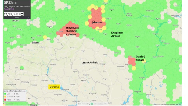
Two Russian airbases deep inside the country were attacked on December 5: the Engels-2 base in the Saratov region and Dyagilevo near Ryazan. The next day an oil tank at the Kursk airfield closer to the border with Ukraine was hit and set on fire.
The Russian government has long interfered with reception of GPS signals, especially near and within its own borders. The early December attacks seem to have motivated an increase in this activity.
More Interference
Information displayed by the website GPSJam.org indicates that, on the first day of the attacks, GPS interference was detected around Moscow, at two airbases to the east, and near the Engels-2 airbase.
Image: RNT Foundation
GPSJam.org uses anomalies in crowdsourced aviation ADS-B data as an indicator of unreliable GPS signals. Note that no such information is available for much of Ukraine as commercial aircraft have been avoiding the airspace since the beginning of the current conflict.
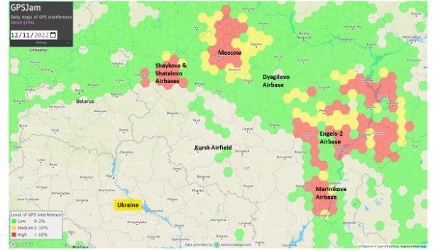
The GPSJam.org depiction of the region six days after the attacks is quite different and has stayed much the same ever since. It seems to show greatly increased interference in the vicinity of the Engles-2 airbase, and new interference around the Marinikova airbase to the south along the Volga River.
Image: GPSJam.org
A History of Jamming and Spoofing
The Russian government has been deliberately and systematically interfering with GPS signals in some places since at least 2016.
The article documented a tech podcaster’s discovery that GPS L2 and L5 signals were being jammed and GPS L1 was being spoofed in the vicinity of the Kremlin. The combination of jamming and spoofing caused receivers in the area to report that, rather than being downtown, they were at the Vnukovo international airport some 20 kilometers away.
The author of the article speculated the spoofing was to protect government officials and buildings from surveillance and attack by UAVs. Since 2013 most larger UAVs have been programmed by manufacturers with the locations of airports and to avoid them. Making UAVs near the Kremlin believe they were at an airport could be an effective part of an overall defense system by causing them to avoid the area.
In 2017 the Resilient Navigation and Timing Foundation examined maritime AIS data and found similar spoofing activity had been occurring in the Black Sea for at least two years. A 2019 report by the nonprofit C4ADS expanded upon this work and revealed spoofing activity at various times and places across Russia. Almost 10,000 instances were documented across ten locations between 2016 and 2018. The report also linked much of the spoofing to the Russian Federal Protective Service and movements of senior government officials. This reinforced the idea that the spoofing was part of VIP protection efforts.
Questions Abound
It is easy to conclude that Russia’s recent increases in interference activity were in reaction to the UAV attacks on December 5 and 6.
Western intelligence and military officials may be arriving at additional conclusions and asking themselves some intriguing questions. One might be why it took six days after the first UAV attack to implement the new interference scheme. The report by C4ADS made it clear that Russian equipment used for wide area spoofing is quite portable.
Perhaps the delay was one of decision making. Some observers have commented that much of the direction for the current conflict comes directly from the top, rather than being delegated to field commanders. It could well be that it took that long for the Kremlin to realize that UAVs were involved and direct equipment to be deployed.
Another question likely being asked is about the selection of locations where interference is being used. Interference activity was observed at the Engels-2 airbase before it was attacked. This seems to have greatly increased after the attack. Airfields at Dyagilevo and Kursk were also attacked, but no interference activity has been observed at either location.
At the same time, substantial new interference activity has been observed at the Marinikova airbase, which was not attacked. There are likely several contributing factors to why some locations have been protected with jamming and/or spoofing and some not.
While Russian forces have a fearsome reputation for electronic warfare and their ability to interfere with GPS signals, the amount of equipment and the number of trained operators may be limited. C4ADS’ finding that spoofing equipment was moved around with VIPs rather than permanently located around the nation could indicate a limited amount.
This would mean that the bases and facilities to be protected must be prioritized. The lack of interference around Kursk and Dyagilevo could mean Russia sees them as less important, or less likely to be attacked again. New interference at Marinikova could mean it is a high value target and in need of protection.
Conversely, some of the new activity could be designed to deceive and draw Ukrainian fire away from higher value targets and toward lower ones. Such is the potential nature of military strategy in war.
Analysts are also probably asking questions about the effectiveness of jamming and spoofing as a defense against a determined UAV-operating opponent.
Interference had been detected at Engels-2 before it was successfully attacked by one or more UAVs. This likely shows that Ukrainian forces disabled any geofencing that might have been originally included as part of the UAVs’ original design. They may have also upgraded the UAVs’ navigation receivers with hardware or software to make them much more resistant to interference from the ground.
Navigation Warfare Increasingly Important
Regardless, the UAV attacks and observed changes in interference activity reaffirm the importance of navigation warfare in modern conflicts. Knowing the location of your forces and of your targets has always been important. In an era of precision strike and autonomous systems, robust and resilient navigation that resists or overcomes interference is even more important.
The U.S. military has long recognized this, establishing its Joint Navigation Warfare Center in 2004. The center focuses on the intersection of positioning, navigation, and timing with electronic warfare and cyber operations. Undoubtedly Russia has identical concerns and probably an equivalent organization.
The current conflict in Ukraine will continue to raise questions for both sides. Not in question, though, is the importance of navigation warfare to this conflict, and that it will be increasingly important in future ones.
CyArk, a California-based nonprofit, used UAVs, lidar and GNSS equipment to scan Big Basin Redwood State Park in Santa Cruz, California and create a model of it. The model shows drastic changes from climate change and the after-effects of the 2020 CZU Lightning Complex Fire.
CyArk was contracted by the California park system and Google Art & Culture to document climate-related changes in the state forest, including the 2020 CZU Lightning Complex Fire, which burned more than 97% of the oldest park in California, destroying historic structures and most of the park. The fire was detrimental to the park’s landscape, which is still plagued by drought.
DJI quad-rotor UAVs, a fixed-wing senseFly UAS, lidar and photogrammetry data brought in by RealityCapture software, and Topcon Positioning Group GNSS receivers among other technologies were used by CyArk to map the large-scale project.
The model created from the flyover of the Big Basin can be seen here.
CyArk digitally documents culturally historical places around the globe in 3D to preserve each site’s story using GNSS and lidar technology. They have worked at more than 200 sites in more than 40 countries.
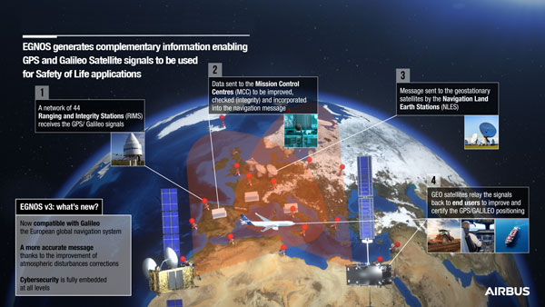
On Dec. 7, the European Geostationary Navigation Overlay Service (EGNOS) V3, a satellite-based navigation augmentation system designed by Airbus, passed the System Critical Design Review (CDR). EGNOS V3 supports safety-critical aircraft applications and will soon provide services to maritime and land users.
New services provided by EGNOS V3 are based on multiple frequencies from GPS and Galileo constellations and will provide protection against cyberattacks. As it successfully passed CDR, this multi-constellation and multi-frequency satellite-based navigation augmentation system is a step forward in improving EGNOS accuracy, robustness, and overall coverage in Europe.
EGNOS V3 relies on three operation centers and 44 monitoring stations across Europe. It monitors the signals from satellite navigation systems and generates augmentation messages broadcast to all users using transponders and geostationary satellites. Airbus is currently designing more Galileo satellites, which will further improve EGNOS accuracy and robustness and the resilience of its signal.
EGNOS is a component of the European Union Space Program and is managed in partnership with the European Commission’s Directorate-General for Defense, Industry and Space, the European Union Agency for the Space Programme (EUSPA) and the European Space Agency (ESA).
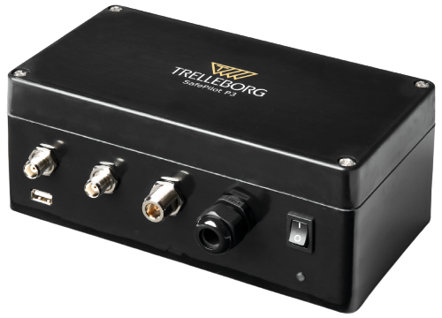
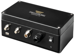
On Dec. 15, Trelleborg Marine and Infrastructure released SafePilot P3, a navigation system that meets Panama Canal Advisory (ACP) standards, which go into effect late next year for Neopanamax vessels. The navigation system provides real-time data on vessel positioning and movement in tight waterways.
SafePilot P3 operates on motion sensors and two GNSS antennas to measure the position and heading of vessels in three dimensions, minimizing time and difficulty associated with piloting procedures. SafePilot P3 has a backup battery to maintain functionality in the event of a power outage.
Image: Trelleborg SafePilot P3
This navigation system improves situational awareness while navigating waterways and ports globally, as it integrates with the ACP-approved Trelleborg SafeCaptain App. It also enhances communication between the captain, pilot, tug operators and canal personnel while vessels are transiting the canal and approaching the port.
SafePilot P3 is an addition to Trelleborg’s SafePilot portable navigation systems, which provide ports with real-time navigation information while giving pilots greater control and accuracy when approaching ports and performing intricate maneuvers.
The South African National Space Agency (SANSA) launched the South Africa Space Weather Center at Hermanus in November to provide real-time space weather forecasts. The space weather center detects space weather conditions such as strong solar flares that could disturb Earth’s magnetic field and severely affect ground-based electrical and electronic systems.
The space weather center collects data in real-time from solar satellites and a ground-based instrumentation network which consists of three kinds of sensors: GNSS receivers, magnetometers and an ionosonde system. Space weather conditions are then broadcast to South Africa and the rest of the continent to provide critical 24/7 space weather alerts for airlines, air traffic control agencies, telecommunications companies and satellite operators.
The International Civil Aviation Organization now recognizes the space weather center, as the launch filled the void in global space weather monitoring and 24/7 forecasting coverage.
SANSA received approval for the space weather center in 2019 and overcame many challenges during its development, such as limited funding for research, personnel, and equipment, as well as the COVID-19 pandemic.