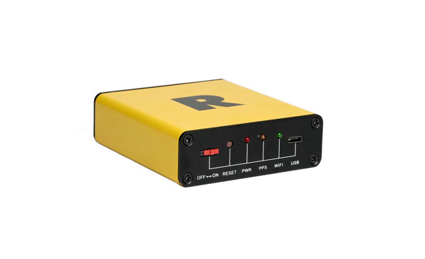
On Jan. 6, ROCK Robotic, a geospatial company specializing in lidar-based data processing and high-definition mapping, announced the availability of ROCK Base, a triple frequency RTK base station. Additionally, ROCK Robotic has partnered with the Web3 GEODNET initiative to support critical applications in civil surveying, high-definition mapping, digital twin creation and more.
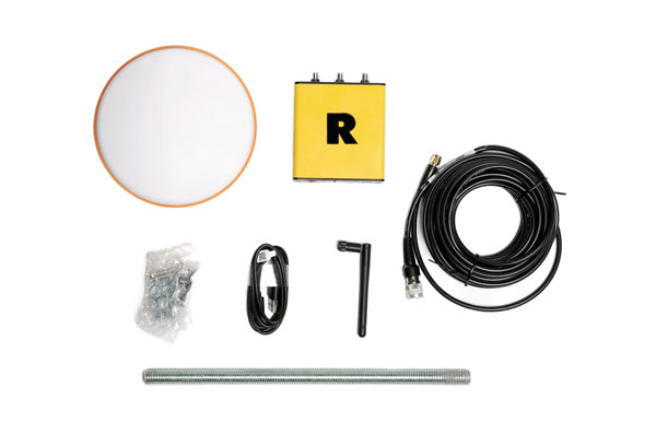
ROCK Base is a resilient, secure, full-constellation GNSS receiver, capable of tracking signals transmitted from GPS, GLONASS, Galileo, BeiDou, QZSS, and the IRNSS navigation satellite constellations. It includes 1,400 channels, survey-grade antennae, cables and antennae-mounting equipment required to set up a permanent continuously operating reference station location.
To make high-definition mapping more accessible and affordable, ROCK Robotic joined the Web3 GEODNET initiative, the largest decentralized GNSS reference network globally. Under the new partnership, ROCK Robotic customers will have access to the GEODNET base-station network to geo-reference ROCK Robotic’s 3D data products to millimeter-level absolute position accuracy, without setting up ground control points. Additionally, ROCK Base is pre-certified on the GEODNET network.
In October 2022, Raytheon Missiles & Defense, a Raytheon Technologies company, received a $207 million contract from the United States Army for Ku-band radio frequency sensors (KuRFS) and Coyote effectors. The Army plans to equip two of its divisions with KuRFS and Coyote effectors to defend against threats from unmanned aerial systems (UAS).
The KuRFS precision targeting radar and scaled Ku-720 mobile sensing radar provides 360-degree detection, identification and tracking of airborne threats. Coyote Block 2 kinetic and Block 3 non-kinetic effectors can defeat single UAS and swarms at high altitudes and long ranges.
The Army’s Mobile-Low, Slow, Small, Unmanned Aircraft Integrated Defeat System, integrates KuRFS and Coyote effectors with Northrop Grumman’s Forward Area Air Defense Command-and-Control system and Syracuse Research Corporation’s electronic warfare system. This creates a mobile deployed system that provides a complete extended-range defense solution.
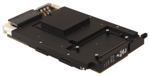
In October 2022, Curtiss-Wright Corporation’s Defense Solutions division, a supplier of modular open system approach-based solutions, released the VPX3-673A module. This module is the first to deliver assured position, navigation and timing (A-PNT) along with alternative RF navigation and pntOS architecture.
The VPX3-673A is a rugged, 3U OpenVPX, form factor module, which integrates with existing navigation sensors in vehicles operating in environments with limited or denied access to GPS, to increase assurance in the platform’s PNT solutions. It is designed to ingest positioning and timing data from multiple sensors and output accurate timing and navigation information on the battlefield using VICTORY data messages.
It is compatible with the United States Army’s C5ISR/EW Modular Open Suite of Standards and aligned with the Sensor Open Systems Architecture Technical Standard 1.0.
VPX3-673A includes a low noise chip-scale atomic clock with intelligence provided by Xilinx MPSoc, an alternative RF navigation receiver and a 10-degree of freedom IMU. It supports an internal or external GPS module via a front panel connector. Additionally, the VPX3-673A provides processing resources and sensor interface capabilities needed for operability with a variety of external processing and sensor units.
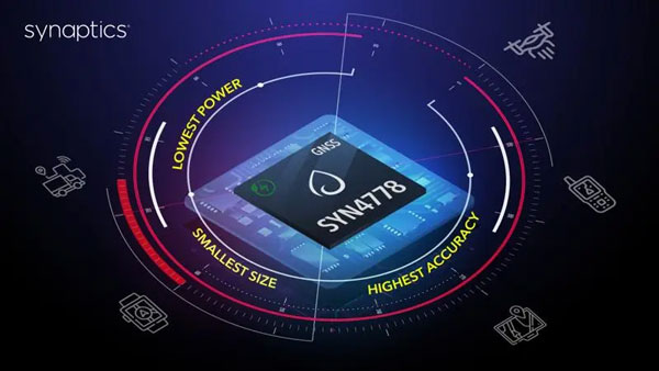
On Jan. 3, Synaptics released the SYN4778, a small, low power, accurate GNSS integrated circuit for Internet of Things (IoT) devices. SYN4778 is designed to extend battery life, reduce product size, and enhance performance of advanced location-based services for IoT devices, including wearables, mobile accessories, asset tagging and tracking systems, UAVS and transportation navigation.
SYN4778 includes advanced multi-path interference mitigation using L5 band signals from GPS, Galileo, BeiDou, NAVIC, SBAS, and Quasi Zenith Satellite System (QZSS). The chip also uses L1 satellite bands to reduce the time to first fix, as well as the power consumed, improving end-user experience, and enabling product developers to add additional functionality and features to their IoT devices.
This GNSS chip includes LTE jamming and signal filtering, and continuous — highly parallel — search and track of all GNSS channels for greater positioning accuracy for LBS applications, specifically in urban environments. Additionally, it offers support for multiple operating systems and third-party software to enable a broader range of application-optimized IoT devices.
SYN4778 is currently only available to select customers.
Cepton, a Silicon Valley-based lidar solutions company, and ALP.Lab GmbH, an Austrian-based provider of autonomous vehicle testing solutions and TE Connectivity, which produces sensors and connectors, have completed a proof-of-concept project called Periscope. Periscope is a vehicle-to-everything (V2X) solution, which extends a driver’s field of view using lidar sensors installed at intersections to warn of road hazards ahead before they are in view.
The companies created Periscope in response to the global issue of traffic accidents involving pedestrians and cyclists. The V2X solution communicates information about road conditions in real time, providing more time to react, preventing accidents and enhancing overall safety.
For the proof-of-concept project, Cepton provided its Helius Smart Lidar System, which combines lidar sensors with edge computing and perception software to provide real-time, 3D object detection and tracking. TE Connectivity contributed its V2X hardware components in the vehicle used for testing and for the surrounding infrastructure, as well as provided technology for an on-board display of the vehicle’s location and road hazards. ALP.Lab supervised the system integration and testing, while also providing the testing area and infrastructure.
Cepton, ALP.Lab and TE Connectivity are planning to collaborate on further testing this year to confirm Periscope’s initial findings.
On Jan. 5, FocalPoint announced an investment from GM Ventures, and collaboration with General Motors (GM), on the integration of next-generation GPS technology in the automotive industry. This collaboration will explore the deployment of electric and autonomous vehicles and aims to apply FocalPoint’s technologies into future vehicles produced by GM to make navigation more precise, especially in urban environments.
Image: FocalPoint
FocalPoint’s Supercorrelation is designed to increase positioning accuracy in urban environments and is highly resilient to spoofing attacks. It will be integrated into GM vehicles to provide more accurate navigation. The goal of the integration is to enhance and expand GM’s Super Cruise, and upcoming Ultra Cruise, hands-free, driving assistance technology.
Supercorrelation is already licensed to u-blox and is in advanced trials with other major manufacturers including Molten Ventures, Greshham House, Passion Capital, IQ Capital, Cambridge Angels and more.
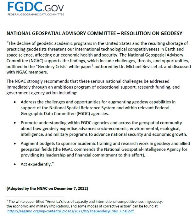
First, happy New Year to everyone. As a follow up to my November 2022 column on the geodesy crisis, I’d like to highlight that the National Geospatial Advisory Committee (NGAC) of the Federal Geographic Data Committee (FGDC) just adopted a resolution on the need for the federal government to understand and aggressively address the US geodesy crisis. See below. This is great news and, hopefully, the FGDC and others will follow up with discussions with other organizations such as the Office of Science and Technology Policy (OSTP) in the White House.
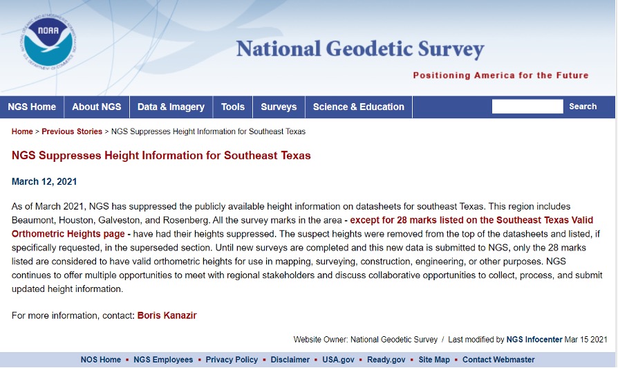
Now for this month’s column. Last year the National Geodetic Survey (NGS) started suppressing height information in Southeast Texas (see my April 2021 and June 2021 columns). See below for more information. Last year’s columns highlighted the potential effects of subsidence on published heights in the Houston, Texas, region which implied that most of the published heights, which are based on older surveys in the region, are not current or accurate. At the time of NGS’s announcement, only 28 marks with orthometric heights were published on NGS datasheets in southeast Texas. Click here for more information and see below.
This column will provide an update on the following: the current set of published orthometric heights in the southeast Texas region based on recent GNSS surveys performed during 2021 and 2022, NGS’s rules for estimating and publishing GNSS-derived orthometric heights using OPUS Projects, and the status of NGS’s GPS on Benchmarks program.
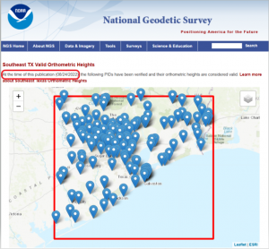
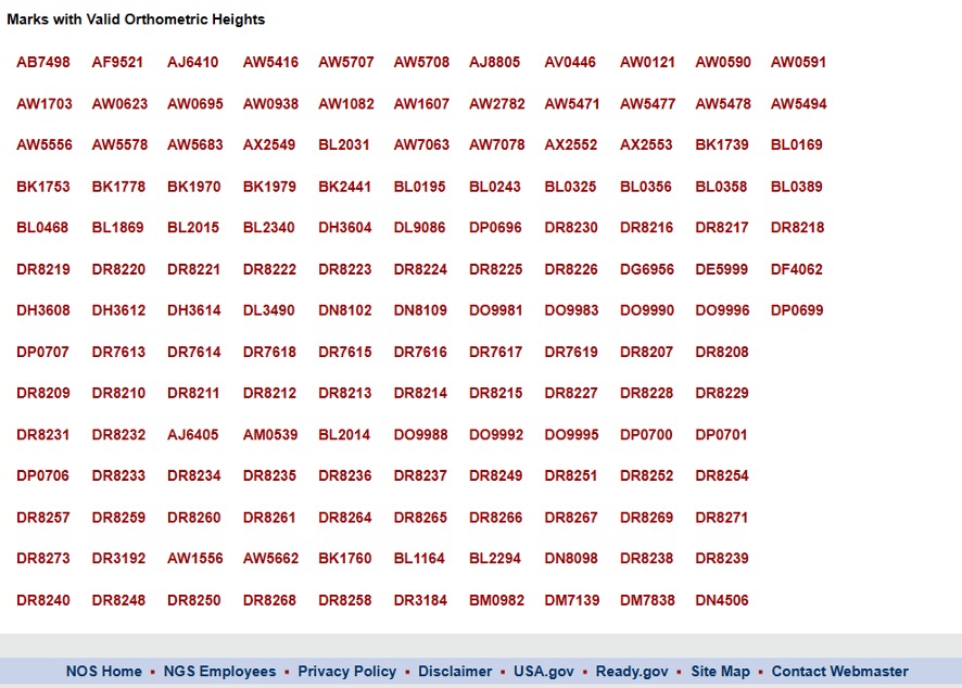
I always retrieve the latest published coordinates using NGS’s datasheet website routine. See the graphic below of the published NAVD 88 orthometric heights as of Nov. 20, 2022 (I used NGS’s monthly archive by State retrieval option). There are currently 147 marks with published orthometric heights within NGS’s definition of the southeast Texas zone of subsidence. From mid-October to early December of 2022, another GNSS project sponsored by the Harris-Galveston Subsidence District (HGSD) was performed in the region. In this project, 154 marks in the southeast Texas region were observed. The results of this project should be published and disseminated by NGS in the spring of this year.
Latest Published Heights in Southeast Texas. Image: Dave Zilkoski
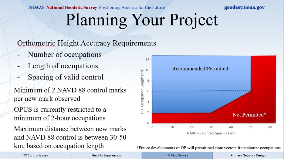
The current version of OPUS projects allows the user to estimate NAVD 88 orthometric heights, providing they adhere to NGS’s recommendations and procedures. A presentation titled “Heights Suppression in Southeast Texas” by Boris Kanazir, NGS, provides guidance on estimating NAVD 88 orthometric heights using OPUS projects.
See below for the requirements for number of occupations, duration of each session, and the spacing of marks with valid NAVD 88 published orthometric heights.
The requirements include:
a minimum of two NAVD 88 control marks per new mark observed
a mark must be observed twice on different days and at different times of the day
the maximum distance between new marks and NAVD 88 control is between 30-50 km, based on session duration
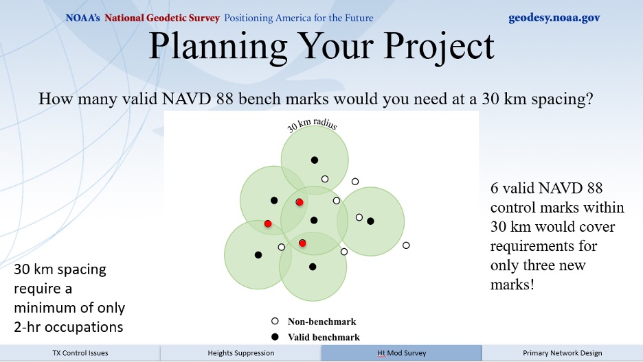
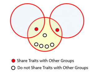
I like to think of this concept as drawing Venn diagrams around marks. See below for an example of the concept.
Venn Diagram. Image: Dave Zilkoski
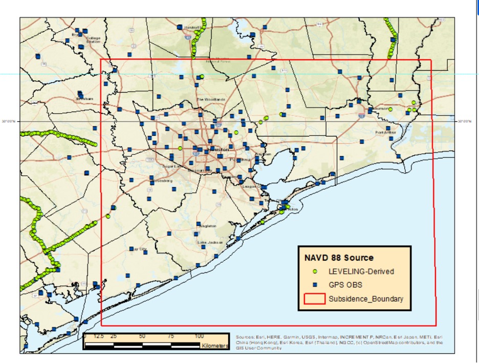
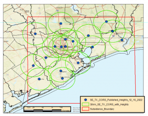
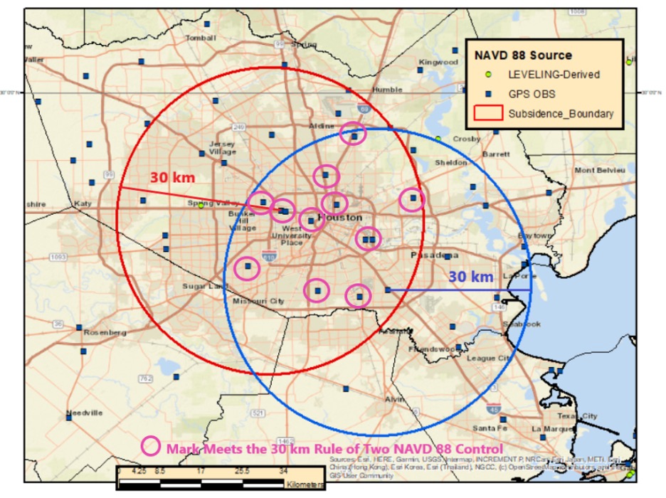
So, what does this mean in the real world? The map below demonstrates the concept in the Houston-Galveston, Texas, region. As shown, many of the 30 km circles overlap, indicating that in these overlapping areas there are two CORS with published NAVD 88 orthometric height. This means that a user can occupy a mark for two hours and use the data from two CORS as NAVD 88 control. Of course, the mark must be occupied twice for redundancy.
30 km Radius Circles around SE TX CORS with NAVD 88 Heights. Image: Dave Zilkoski
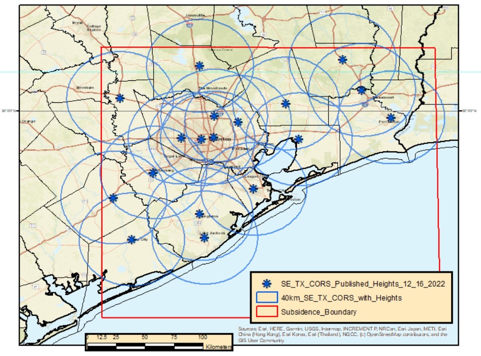
Increasing the radius to 40 km includes more overlapping areas. This means that the user would have more overlapping areas with two CORS that have published NAVD 88 orthometric heights, but the marks would have to be occupied twice for at least four hours each time.
Image: Dave Zilkoski
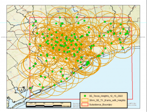
Now, when you apply a 30 km radius around the current 147 marks that have published NAVD 88 heights, most of the region has overlapping areas (see below). This means that the user could occupy two of the NAVD 88 marks along with any new marks for at least two hours.
30 km Radius Circle Around all 147 NAVD 88 Marks in SE TX. Image: Dave Zilkoski
The previous figure may seem confusing because of all the circles. In the example below, based on only two marks, 11 marks fall inside the overlapping sections of the two circles. They could be established using the two NAVD 88 control marks that were used to make the 30 km circles.
Example of Two 30 km Radius Circles. Image: Dave Zilkoski
As depicted in my June 2021 column, the Houston-Galveston, Texas, region is subsiding. The map below provides the latest estimates of subsidence in Houston-Galveston, Texas, region based on a Harris-Galveston Subsidence District (HGSD) report “Determination of Groundwater Withdrawal and Subsidence in Harris and Galveston Counties – 2021“ published in 2022. Most of the rates are small, less than 0.5 cm/year, but some are greater than 1 cm/year. This means that some marks may have subsided around 5 cm in five years.
Estimate of subsidence in SE TX. Image: Dave Zilkoski
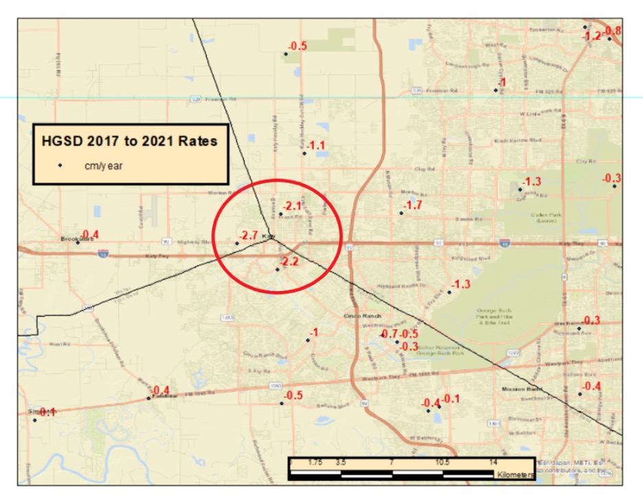
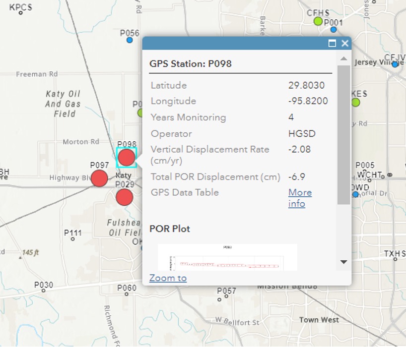
The surveying and mapping community has done a tremendous job of increasing the number of published heights in the Houston-Galveston, Texas, region (from 28 to 147). That said, the amount of movement in the Katy region is more than -2 cm/year (see box titled “Estimate of Subsidence in the Katy Area”). That means, the marks in this area may subside 10 cm in five years.
Estimate of subsidence in the Katy Area. Image: Dave Zilkoski
Heights that change 10 cm cannot be considered NAVD 88 control marks. NGS’s OPUS Projects User Guide states the following about superseding a mark’s coordinates:
“Users should review the newly adjusted coordinates on user marks to decide whether they recommend that the user mark be re-determined (re-published). Typically, this would happen if the coordinates have shifted by more than 2 centimeters horizontally or 4 cm vertically from the published coordinates marks.”
Therefore, these marks in the Katy region may not be valid NAVD 88 control marks in about two years. Even marks that are subsiding at 1 cm/year may not be valid NAVD 88 control marks in about four years.
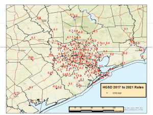
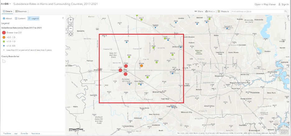
The community needs to maintain these marks to account for movement in the region. As previously stated, the Harris-Galveston Subsidence District (HGSD) has marks, denoted as PAMS, that are occupied continuously for a week several times throughout the year. These PAMS and the CORS in the area could be used to estimate crustal movement rates and maintain a set of valid, published heights in the region. See the boxes titled “ArcGIS Online HGSD Subsidence Rates” and “PAM 98 Subsidence Rate.” Additionally, the Texas Spatial Reference Center (TSRC) could provide the appropriate services to help maintain the published coordinates. The TSRC website states, “The technical mission of TSRC is to conduct basic and applied research contributing to NGS’s national Height Modernization program. TSRC is a repository for information used by researchers to develop improved understanding of elevation, geodetic and vertical datums in the state of Texas. The TSRC goal is to re-establish accurate evaluations throughout Texas in cooperation with qualified geospatial scientists, professional engineers, and professional land surveyors.”
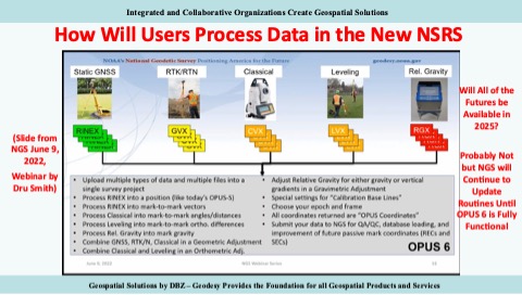
In 2025, NGS will replace all three North American Datum of 1983 (NAD 83) frames and all vertical datums, including the North American Vertical Datum of 1988 (NAVD 88), with four new terrestrial reference frames and a geo-potential datum. As stated in my previous columns – April 2022, April 2021, June 2020 – the new reference frames will rely primarily on Global Navigation Satellite Systems (GNSS) as well as on a gravimetric geoid model. These new reference frames will be easier to access and to maintain than the current NSRS. NGS will provide tools similar to the OPUS suite of routines that will facilitate users’ ability to submit data to NGS to maintain and publish survey marks. See the graphic below.
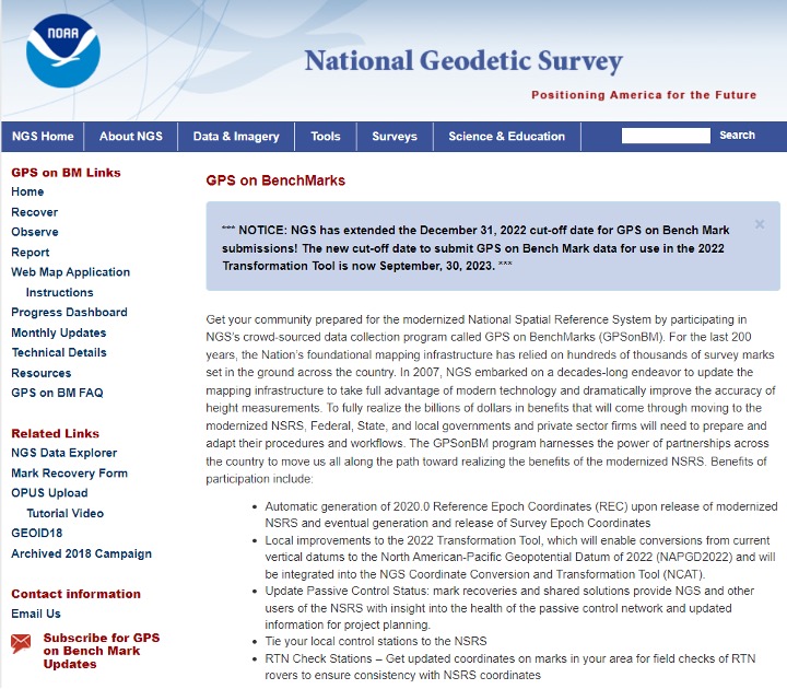
I would like to highlight that NGS has extended the cut-off date for submitting data for use in the 2022 Transformation Tool. The new cut-off date is Sept. 30 (see below).
This column provided an update on the current set of published orthometric heights in the southeast Texas region based on recent GNSS surveys performed during 2021 and 2022, NGS’s rules for estimating and publishing GNSS-derived orthometric heights using OPUS Projects, and the status of NGS’s GPS on Benchmarks program. Additionally, it highlighted that the NGAC of the FGDC adopted a resolution on the need for the federal government to understand and aggressively address the United States geodesy crisis. This is a good step forward, and I hope that others will follow up with discussions with other organizations such as the OSTP in the White House. Finally, “The Geodesy Crisis” white paper can be downloaded from the American Association for Geodetic Surveying (AAGS) website.
I hope everyone has a happy new year filled with optimism, happiness and a generous amount of enthusiasm and fun.
The European Union Agency for the Space Programme (EUSPA) along with the European Commission, have published guidelines that specify the baseline applicable to the Galileo Open Service Navigation Message Authentication (OSNMA) receiver service provision phase. The new documents include the OSNMA Signal-in-Space (SIS) Interface Control Document (ICD), and OSNMA Receiver Guidelines.
The OSNMA SIS ICD specifies, among other things, the interface between the Galileo Space Segment and the Galileo User Segment. This document is an addition to the Galileo Open Service (OS) SIS ICD.
The OSNMA Receiver Guidelines provide generic instructions for the user segment implementation of the OSNMA functionality and complement the OSNMA SIS ICD. Additionally, the guidelines explain user capabilities and steps to implement to verify the authenticity of the Galileo navigation message.
Both documents will be used for the upcoming OSNMA Service Provision Phase that will begin after the OSNMA Service Declaration. They have been developed as an evolution of the Galileo OSNMA User ICD for test phase (v1.0) and the Galileo OSNMA Receiver Guidelines for test phase (v1.1). Copies of the documents can be found here.
California lawmakers have passed a bill prohibiting OEMs of autonomous vehicles from marketing their vehicles as ‘fully self-driving.’ This law went into effect Jan. 1.
This legislation was passed in mid-September of 2022 and states that manufacturers are prohibited from selling new passenger vehicles with autonomous driving features without fully disclosing their capabilities and limitations. Companies such as Tesla, and other OEMs in California, will no longer be able to market vehicles as ‘fully autonomous,’ as the new bill states that it is “considered a misleading advertisement.”
Any violation of the new legislation will be punished as an infraction. Based on this, it is unclear what the exact punishment will be for OEMs that violate this policy.
Senate Bill No. 1398 will be added to Section 24011.5 of California’s vehicle code. The full bill can be found here.
On Dec. 28, Atwell, a Michigan-based, full-service consulting, engineering, and construction services firm, announced its agreement to acquire Dempsey Surveying Company, expanding business in the Midwest. The deal is expected to close on Dec. 31.
The acquisition of Dempsey Surveying Company, based in Cleveland, Ohio, broadens Atwell’s presence in the Midwest and expands surveying capabilities, as well as other services, to new and existing clients.
Dempsey Surveying Company’s services include topographic surveys, construction staking, boundary services, Federal Emergency Management Agency (FEMA) flood elevation certificates, surface model TINs, GPS services, aerial mapping, and UAV services. The company has a variety of clients across several industries and has maintained more than 50 years of survey records.
This is Atwell’s third acquisition this quarter. In November, Atwell acquired Cross Surveying, a Florida-based land surveying firm, and Ben Dyer Associates, a Maryland-based engineering firm.
On Nov. 11, the last Galileo satellite of first-generation series was shipped from ESA’s ESTEC Test Centre, Europe’s largest satellite testing facility. Galileo is Europe’s largest satellite constellation and one of the most accurate satnav systems in the world.
Galileo’s development began two decades ago with two test GIOVE satellites, followed by a series of other operational launches to add to the constellation. The current constellation consists of 34 Full Operational Capability satellites, the initial two GIOVE satellites, and the Galileo In-Orbit Validation satellite. Galileo Second Generation satellites are already in development.
ASENSING, a Chinese positioning solutions company for autonomous vehicles, is ready to provide its navigation systems globally. The company already has more than 500,000 autonomous vehicles integrated with its navigation systems and is discussing global product expansion with major Western brands.
ASENSING is the first in series production of an automotive solution that combines IMU and GNSS, enabling it to develop an algorithm to maintain navigation accuracy at various temperatures. Its positioning solutions are designed for autonomous driving at L2 level and above and meet functional safety requirements.
ASENSING has received nominations from more than 20 OEMs to provide solutions for more than 70 vehicle models. Additionally, the company has partnerships with traditional brands such as SAIC, Geely, and Chery, as well as with new energy vehicle makers, including XPeng, Li Auto, and NIO.
The company has three global branches, in the United States, Germany, and Japan with plans to launch more smart plants in east and south China to accommodate for an influx of orders. ASENSING will exhibit its mass-produced positioning solutions at the Consumer Technology Association’s Consumer Electronics Show 2023 in Las Vegas, Nevada.