Application empowers users with expert visualization and analysis of lidar
Enview, a pioneer in the scalable processing of 3D geospatial data, has launched Enview Explore, a powerful web application that leverages artificial intelligence (AI) and cloud computing to automatically process 3D data at a high speed and scale.
Also, Robert Cardillo, former director of the National Geospatial-Intelligence Agency (NGA), has joined the company’s board of directors. Following an oversubscribed round of funding in May, the company continues to experience growth and momentum in the market.
Enview’s technology has been deployed on thousands of square miles worldwide to protect vital infrastructure and support mission-critical operations. Its unique method for classifying 3D data using neural networks and deep learning techniques reduces time to action by focusing on finding meaningful insights in 3D data.
Previously offered as custom services for organizations such as Pacific Gas & Electric and the United States Air Force, this groundbreaking technology is now available for the first time as an easy-to-use, self-service web application.
Screenshot: Enview
“Enview has built the world’s most scalable AI platform for transforming 3D point clouds into insight and action,” said San Gunawardana, Ph.D., co-founder and CEO of Enview. “We are solving one of the hardest problems in machine perception, and applying it to some of the most grounded and impactful challenges facing society. It is our goal to empower people with the confidence to perceive and navigate a rapidly changing world; Enview Explore is the natural next step in this journey and our team is excited to place this groundbreaking capability directly into the hands of operational end-users.”
Key benefits of Enview Explore include:
The power of 3D data. Three-dimensional unstructured data, such as lidar, contains incredible detail but is painfully slow to analyze manually. Enview solves this problem by combining its novel AI with the power of cloud computing to automate 3D classification and segmentation, giving users scalability that can support even nation-sized datasets.
High speed. While current methods can take weeks or more to process data, Enview provides actionable insights in minutes. Enview Explore utilizes a new and innovative approach that applies AI to 3D data, yielding significantly faster results than traditional lidar software.
Total data control. Enview Explore removes the need for outsourcing lidar to a third party by giving users the ability to perform classification, segmentation, terrain modeling, change detection, feature extraction, and intuitive visualization directly inside the application.
Screenshot: Enview
“With this release, we wanted to show the world that you don’t need to be a professional to get expert analysis from lidar,” said Anthony Calamito, VP of Products for Enview. “Lidar and other 3D data hold tremendous value and provide unparalleled insight over 2D data sources. While unlocking that value traditionally has required an in-depth understanding of specialty software, Enview Explore lets anyone create meaningful insight from 3D data with just a few clicks.“
The company also announced that Robert Cardillo has joined its Board of Directors. Cardillo served as the sixth director of the NGA from 2014 through 2019. In that position, he led the NGA under the authorities of the secretary of defense and director of National Intelligence to transform the agency’s future value proposition through innovative partnerships with the growing commercial geospatial industry.
“Mapping the world in 3D opens new possibilities for national security and mission-critical infrastructure, including some of the most important challenges facing our nation today,” said Cardillo. “Enview has completely changed the game when it comes to what’s possible with lidar visualization and analysis, making unstructured data accessible and easy to use: in other words, creating coherence out of chaos. With a shared purpose and commitment, I look forward to working with the Enview team toward the future the world demands and our customers deserve.”
RedTail Lidar System’s RTL-400 delivers the trifecta
Summer is here, and with it comes the challenge of creating accurate topographic maps under tree canopies. The adoption of drone-based, 3D light detection and ranging — or lidar — is emerging as the go-to sensing technique to meet this challenge consistently, safely and cost effectively.
Designed specifically for use on small drones, the RTL-400 from RedTail Lidar Systems was developed with technology licensed from the U.S. Army Research Laboratory (ARL). The RTL-400 is designed to provide high-resolution 3D images of objects on the ground, flying at an altitude of up to 400 feet.
The RedTail team recently partnered with the West Virginia Department of Environmental Protection (WVDEP) Division of Mining and Reclamation to demonstrate the RTL-400’s ability to generate an accurate digital terrain model (DTM) under “leaf on” conditions. This can be challenging, because pulsed laser light needs to reach the ground to generate laser light ground returns.
One mission of the WVDEP Division of Mining and Reclamation is to assure compliance with the West Virginia Surface Mining and Reclamation Act and other applicable state laws. This task requires ongoing monitoring, mapping and assessment of sites across the state that are actively being reclaimed.
Originally utilizing photogrammetry to generate point clouds, the WVDEP was unable to create the accurate, under-canopy DTMs that they desired. Looking for an alternate method, they began to consider lidar.
The RedTail lidar team met with WVDEP representatives at a mine reclamation site in a remote area of south-central West Virginia. The terrain was a mixture of rolling hillside covered with grasses, brush and tree stands.
The RTL-400 demonstration flight mapped approximately 20 acres of the reclamation site in 12 minutes, flying at an altitude of 196 feet and a speed of 18 mph.
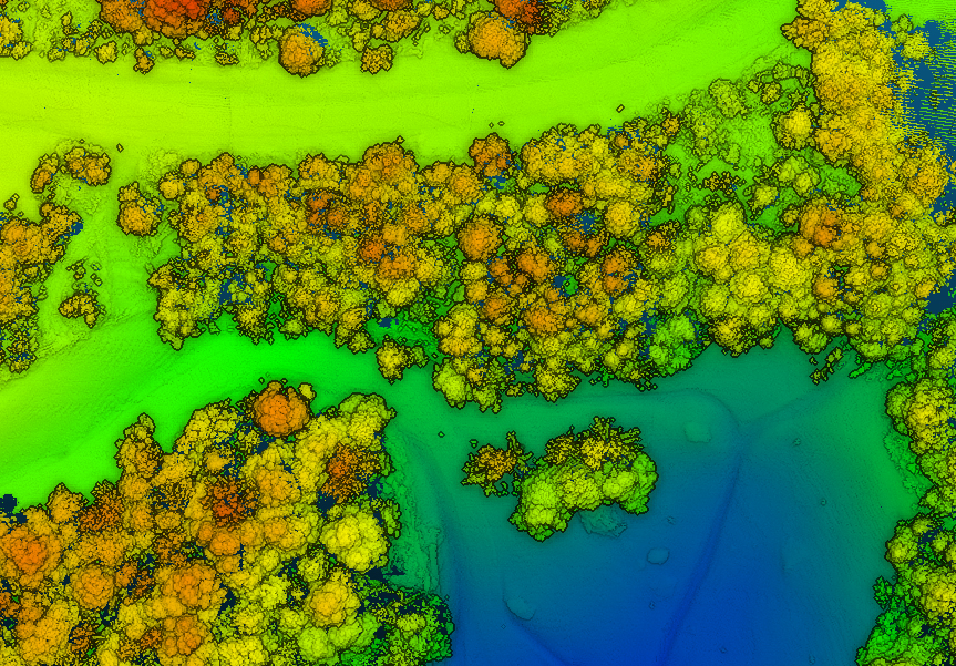
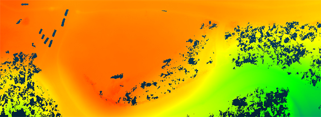
Once the data was collected, a digital terrain model (DTM) was created, revealing the RTL-400’s ability to generate the high-resolution, high-density point cloud needed to accurately map the terrain beneath the tree. 
Digital terrain model (DTM) generated from RTL-400 point cloud. (Image: RedTail)
The RTL-400 delivered all three key elements needed to provide DTMs in foliated areas:
a small beam divergence of 0.5 milliradians (.03 degrees) with a spot size of just 2 inches diameter at the canopy cover
the ability to analyze up to five returns from every transmitted pulse so that returns from the ground can be received and processed
a pulse density of 800 pulses in every square meter of the canopy (for the WVDEP flight). 
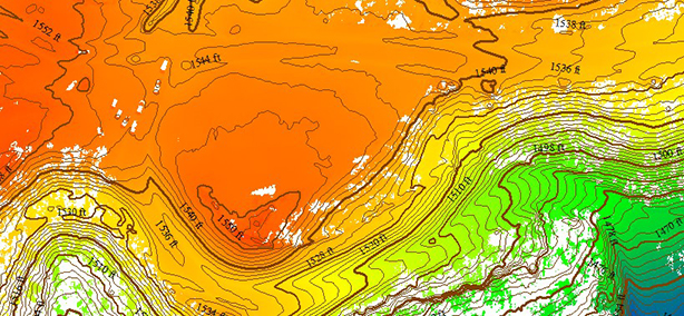
RTL-400 generated digital terrain model (DTM) overlaid with contour map. (Image: RedTail)
RedTail Lidar Systems is a division of 4D Tech Solutions Inc., a company focused on providing innovative technology-based solutions to address government and commercial customer needs. RedTail’s in-house technical expertise — coupled with a full suite of software and hardware design and manufacturing tools — allows the company to develop custom lidar solutions for manned and unmanned vehicle applications.
While connected cars provide wonderful advantages, their integration with cloud connectivity come with a heightened risk for cyber attacks.
Commentary by Alexander Meisel
When it comes to connected cars, automakers are innovating fast. Consumers are experiencing increasing amounts of futuristic features, be they passenger connectivity, automated speed regulation or autonomous driving capabilities.
However, these innovations and their integration with cloud connectivity come with a heightened risk for cyber attacks. A recent study conducted by U.K. self-driving hub organization Zenzic found that becoming cyber-resilient will be the biggest technical obstacle to successfully deploy self-driving cars on roads by 2030. This mountain will be a big one to surmount, and it’s only growing in size: The auto industry has seen a 94% year-over-year increase in hacks since 2016.
How can automakers prioritize security while keeping up with the demand for innovation in today’s connected cars?
Carmakers must consider security from day one
To make sure that security is built into the very foundations of a car, automakers must make it a priority from the first day of design. This focus is lacking amongst carmakers at the moment. In fact, 19% respondents to one survey said they don’t do enough security testing in the design phase, and only 28% said that they do a lot of the testing during the design stage.
Automakers can use design principles to build in security from the outset. For example, the principle of complete mediation allows for enhanced security as it ensures that a software stem “requires access checks to an object each time a subject requests access.” This means that attackers are only invited to exploit a system on one single occasion due to checks on subjects’ permissions.
Carmakers can also ensure that they are not sacrificing security by considering its importance when purchasing components from separate suppliers. These components must be specific enough to enable security in the system, but generic enough to allow for innovation.
Automakers must make cybersecurity a priority from the first day of design.
Here, companies can leverage the software engineering principle of interface segregation. This means that a shrunken, clear interface should be supplied by the vendor, so that the customer only uses the methods that are of interest to them.
In turn, this allows systems to remain decoupled and thus easier to then build a rich interface on top of. However, carmakers will have to stay on top of the security of the part in the development phase, and ensure that dormant functions are not abused by at least logging their execution once somebody tries to call them out of context.
Developers and cybersecurity experts must become a core part of the team
Software development is relatively new territory for carmakers. Now, cybersecurity is a key component of building connected cars, and automakers need to embrace developers that have expertise in this area and make them part of the core team.
This cultural change must be championed by the business leaders to allow car security to advance alongside the innovative features that the industry is building. This can be done by implementing DevSecOps ideology into the team, in order to “build the mindset that everyone is responsible for security.”
Car development teams will likely need a group of cybersecurity experts who can educate the rest of the developers and are willing to participate in the development process in order to check and implement safe and secure functions. If a company doesn’t have this kind of expertise in-house, they can partner with an expert third-party to help them along this journey.
Innovation and security can complement each other
Cybersecurity doesn’t mean sacrificing feature innovation: developments are being made in the field of security too, such as biometric technologies that can be integrated into car design.
For example, Blackberry’s QNX technology “has built in concepts for hardware and software trust validation, hypervisor to maintain a separation between the safety critical and infotainment systems, and a core operating system which passes all the functional safety standards,” according to the company’s senior VP SVP, head of QNX, John Wall. Innovation need not suffer at the hands of security, and vice-versa.
Potential AV thieves would first look to use GPS data to disable or falsify a car’s GPS system, making it untraceable.
In addition, the world’s leading electric vehicle provider, Tesla, ensures security in its cutting-edge, connected cars by sending security updates to cars’ operating systems overnight, and even providing awards for hackers that manage to hack its cars.
Looking ahead to the possibilities of autonomous vehicles (AV) that can drive passengers without needing to have their owner inside, innovation in GPS will be necessary to ensure security and accountability of the car. Potential AV thieves would first look to use GPS data to disable or falsify a car’s GPS system, making it untraceable.
However, carmakers can make this impossible for hackers by not just logging the data in its raw form, but also combining it with other car data using cryptographic algorithms. This ensures that the GPS data remains traceable even after the hardware has been taken apart and sold on the auto-parts black market. In this way, the signature of the original data combined with the GPS position adds an additional layer of security.
Integrating security into connected car design is no simple feat, but it’s a necessary one for carmakers that want to ensure the safety of their passengers while on the roads. By using design principles, diversifying expertise within development teams, and understanding that security and innovation need not be a trade-off, they can do just that.
Alexander Meisel is an automotive cybersecurity engineer at intive. He has a computer networking diploma from Hochschule Furtwangen University, and he has served as a CTO and Development Team Director in previous companies. He has experience with venture capital, successful M&As, and product and technical marketing strategies. He is also a public speaker at technical conferences and trade shows.
On July 23, the 2nd Space Operations Squadron (2 SOPS) gained Satellite Control Authority of GPS satellite vehicle number 76 — also known as GPS III SV03 — which was launched on June 30. This handover was special: for the first time, a crew of eight women space operators took control of the satellite.
Schriever’s 2 SOPS, the providers of GPS signals to billions of users worldwide, made history July 23 when a crew of eight women space operators gained satellite control authority of satellite vehicle number 76 (SVN 76), previously known as GPS III SV03.
The crew included 1st Lt. Kelley McCaa, 2 SOPS satellite vehicle operator; 1st Lt. Alexis Thuli, 2 SOPS operations assistant flight commander; Staff Sgt. Kelly Malone, 2nd SOPS satellite systems operator and crew chief; 1st Lt. Mary McLaughlin, 2 SOPS payload system operator; 1st Lt. Mikayla Roberts, 2 SOPS mission analyst; Senior Airman Joelle Schritt, 19th SOPS mission planner; Airman 1st Class Gillian Clover, 2 SOPS satellite systems operator; and Airman 1st Class Larissa Contreras, 2 SOPS SSO.
“It’s like the grandparents hand the keys to the parent, then the parent hands the keys to us,” said McCaa. “When a new satellite is launched, we don’t have full authority of it. [Lockheed Martin] takes it over [after launch], then we bring it into our systems and then we actually gain full control of [the satellite] as a squadron.”
The 2nd Space Operations Squadron gained satellite control acceptance of satellite vehicle number 76, July 23, 2020, at Schriever Air Force Base, Colorado. The new satellite will provide more than 5 billion users across the globe with stronger precision, navigation and timing signals. It will also bring improved capabilities to warfighters. (U.S. Air Force photo by Dennis Rogers and Kathryn Calvert)
The new satellite will provide more than 5 billion users across the world with stronger precision, navigation and timing signals, Schriever Air Force Base said.
“With these new satellites, they have a lot of capabilities we didn’t previously have,” said McCaa. “There are certain things the new generation of satellites are capable of doing that are brand new to us, and will immediately enhance our GPS signal, helping the warfighters down-range.”
The crew included eight uniformed 2 SOPS and 19 SOPS (the Air Force Reserve component) Airmen who gained SCA of the satellite.
“We have a lot of females in the squadron, and given the crew scheduling, we had the opportunity to establish an all-female crew,” said Thuli. “We decided to have this female team on crew during the SCA, creating a more historic event for the squadron.”
Maj. Lucia White, 2 SOPS assistant director of operation, said the 45th Space Wing female meteorologists at Cape Canaveral Air Force Station, Florida, who determined weather was suitable for rocket launch June 13, inspired her to bring the idea to life in 2 SOPS.
First Lt. Mikayla Roberts, 2nd Space Operations Squadron mission analyst, poses with a model satellite July 23, 2020, at Schriever Air Force Base, Colorado. Roberts was one of eight women who worked on the historic all-female crew. (U.S. Air Force photo by Dennis Rogers and Kathryn Damon)
“We want to inspire future generations of young women and let them know they can have a place in the Space Force,” White said. “[The Space Force] is the place to be, especially for those who may have barriers to overcome.”
In addition to the operational crew, Brig. Gen. Traci Kuekermurphy, Mobilization Augmentee to the Space Force Director of Operations and Lt. Col. Maggie Sullivan, Space and Missile Systems Center, granted SCA approval for their respective entities making the entire transfer an all-female event.
Not only did 2 SOPS and the 45th SW have female crews, the Department of the Air Force also made history when it selected Chief Master Sgt. JoAnne Bass to serve as the 19th Chief Master Sergeant of the Air Force. Bass is the first woman to serve in this role.
According to the National Science Foundation, women make up only 28% of employment in science and engineering career fields. Furthermore, an even smaller percentage of women serve in the Air Force, at about 21%.
Feature image: The women of the 2nd Space Operations Squadron made history as the first ever all-female space operations crew July 23, 2020, at Schriever Air Force Base, Colorado. The crew gained satellite control acceptance of SVN-76, officially adding another satellite to the GPS III fleet. (U.S. Air Force photo by Dennis Rogers and Kathryn Calvert)
Collins Aerospace’s Mike Shepherd discusses the company’s MPE-M Type II GPS receiver at ION GNSS+ 2019. According to the company, it is now accepting orders for the receiver, which received security certification in the spring.
A roundup of recent products in the GNSS and inertial positioning industry from the August 2020 issue of GPS World magazine.
OEM
Photo: Xsens
RTK motion sensor
Provides Centimeter positioning
The MTi-680G is an integrated GNSS/inertial navigation system (INS) module that features an integrated real-time-kinematic (RTK) GNSS receiver, as well as providing synchronized 3D attitude and heading outputs. Its firmware accelerates the module’s internal signal processing compared to non-RTK modules. Synchronizing the global position coordinates with the module’s attitude, heading and velocity outputs, the MTi-680G can provide a comprehensive positioning and navigation output for any carrier device, including high-speed drones, at a maximum output data rate of 400 Hz. Other applications include precision agriculture, autonomous vehicles and coastal maritime equipment. Xsens provides out-of-the-box operation with MTi development kits.
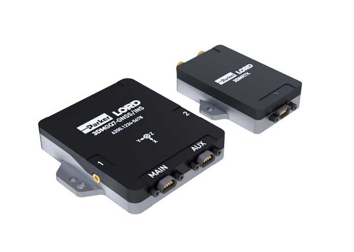
The 3DM-GQ7 is a dual-antenna real-time kinematic (RTK) inertial navigation system with multiple integrated aiding sensors and support for external aiding. It has two integrated RTK-capable multi-band multi-constellation GNSS receivers, integrated barometric pressure sensor, magnetometer, and hardware support for wheel odometry. It also has an application programming interface (API) for external sensor measurements. The 3DM-GQ7 provides seamless operation during temporary GNSS signal outages and online tracking of inertial measurement unit (IMU) error sources for superior dead reckoning. An optional network RTK receiver, the 3DM-RTK, allows users to communicate with the company’s SensorCloud RTK Connection network for an all-in-one solution.
Hexagon | NovAtel has released its first purpose-built driver, powered by Robot Operating System (ROS), to support its OEM7 family of GNSS receivers. The driver provides an optimized interface enabling users to accelerate autonomous development projects by quickly incorporating NovAtel OEM7 receivers into custom applications. The driver is available for immediate download through the new NovAtel GitHub repository or as a ROS Binary Package for direct installation.
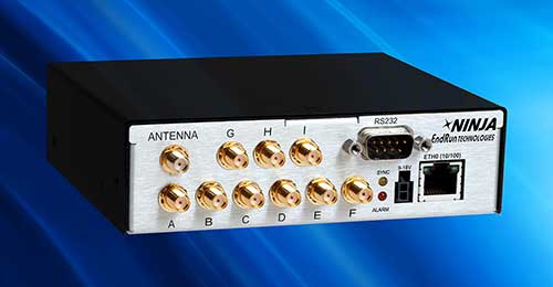
The third-generation Ninja Precision Timing Module (PTM) — optimized for size, weight and power (SWaP) — can be easily integrated into 1U host systems or deployed as a cost-effective standalone time and frequency standard. The resilient GPS-synchronized Ninja is based on the core of EndRun’s Meridian II Precision TimeBase instrument, providing time accuracy of <10 nanoseconds RMS to UTC(USNO). Up to nine optional, user configurable, time and frequency outputs are available with accuracy, stability and ultra-low phase noise. Ninja’s network interface includes a robust Network Time Protocol (NTP) server as well as secure management.
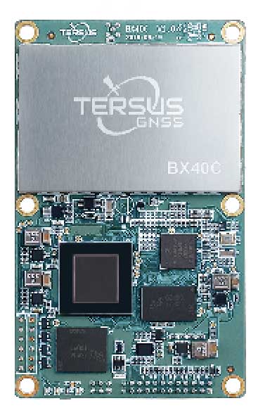
Powered by ExtremeRTK GNSS technology, the BX40C board can support multi-constellation and multi-frequency all-in-view satellite tracking to achieve centimeter-level positioning and improve the continuity and reliability of the RTK solution, even in harsh environments. Its enhanced positioning accuracy and constellation tracking can control deviation within 3 centimeters for surveying and mapping applications. It also is suitable for high-precision positioning. It can be integrated with autopilots and inertial navigation units. It offers 4 GB of built-in memory for data collection, and is compatible with other GNSS boards via flexible interfaces, smart hardware design and commonly used log/command formats.
The Spectratime mRO-50 is designed to meet the latest commercial, military and aerospace requirements where time stability and power consumption are critical. It provides a one-day holdover below 1 microsecond and a retrace below 1 x 10⁻¹⁰ in a form factor sized 50.8 x 50.8 x 19.5 millimeters. It takes up only 51 cc of volume and consumes only 0.45 W of power. The Spectratime mRO-50 provides accurate frequency and precise time synchronization to mobile applications, such as military radio-pack systems in GNSS-denied environments. It is also suitable for UAVs and underwater applications.
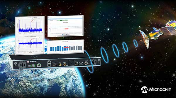
The BlueSky GNSS Firewall has received a major software update. The firewall provides a higher level of resiliency against GPS vulnerabilities for systems dependent on GPS signal reception. Microchip developed Release 2.0 to address operators’ evolving requirements after participating in GPS Testing for Critical Infrastructure events hosted by the Department of Homeland Security. It performs real-time analysis to detect jamming and spoofing for protecting reception of the GPS signal and hardening response and recovery to avoid signal disruption. Release 2.0 includes charting and advanced threshold settings of GNSS observables such as satellites-in-view, carrier-to-noise, position dispersion, phase time deviation and radio frequency power level to simplify system turn-up and deployment.
Particle’s Tracker SOM (system-on-module) provides a powerful GNSS receiver, microcontroller and advanced peripherals in a compact form factor. Tracker SOM can be tailored for organizations or serve as a fully certified foundation for OEMs developing commercial products. A high-gain GNSS antenna accurate to 1.8 meters is provided. The asset-tracking system is built on the Particle platform, spanning integrated internet-of-things (IoT) hardware, edge software, connectivity and cloud-based management software. It can track the real-time location of critical assets and capture additional intelligence such as temperature and acceleration as well as remotely control mobile equipment and vehicles.
The Geotab Public Works solution for North America helps state and municipal government agencies improve fleet operations and increase operational efficiencies. Fleet managers receive operational data on all government vehicle types on a single platform, with toolsets to remain compliant, reduce costs and maintain road safety. Vehicles tracked include salt spreaders, snowplows, street sweepers and waste-management vehicles. It supports material management, compliance, accountability and liability. Fleets can more accurately measure material usage, such as salt, and are better able to control costs and environmental impact. It is available as a configurable add-on for the MyGeotab platform, allowing municipalities of all sizes to customize their databases to help meet specific needs.
Scout provides the capability to securely obtain and broadcast a form of network remote ID. Because it is open source, both hardware and firmware can be enhanced and incorporated into a virtually limitless set of scenarios. Altitude Angel also has made available a surveillance API that allows integrators to both share and receive flight data from a variety of sensors and devices in near real time, providing a comprehensive real-time picture of the airspace. Scout offers two-way communication enabling the Altitude Angel UTM service to help the drone avoid collisions or restricted airspace. It will work in combination with a pre-flight (flight-plan sharing) service and is supported through integration with Altitude Angel’s Tactical Conflict Resolution Service. Scout will enable the drone to report its real-time location using GPS-type sensors and relay this data via a secure, encrypted mobile communications link to Altitude Angel.
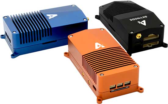
Unifies flight controller, mission computer and connectivity
Skynode unifies a flight controller, mission computer and wireless connectivity in a compact embedded design. It enables the complete Auterion software platform to accelerate the development of enterprise-ready products for drone manufacturers.Skynode can be integrated into any type of airframe: quads, multi-rotors, vertical-takeoff-and-landing (VTOL) and fixed-wing drones. Skynode enables the Auterion software platform with enterprise workflow integration, advanced autonomy features, mission planning, live video streams, operations dashboard, flight analytics and cloud-based predictive maintenance. Built on stable open-source software and industry standards, Auterion is highly interoperable with integrations from a host of partners in an open, future-proof ecosystem.
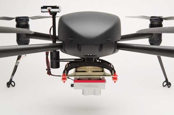
The Draganflyer Commander Ag-Pro Package includes everything needed to perform crop health assessment, irrigation monitoring and yield optimization. It combines the MicaSense RedEdge-MX multispectral sensor and the Draganflyer Commander UAV for projects requiring long flight times, a high level of data resolution and accuracy and data security. The Commander is an electric multirotor UAV built on Draganfly’s patented carbon fiber folding airframe. Its dual-battery system powers 35-minute flight times, and its automated flight planning tool allows users to quickly create coverage areas and flight plans. The RedEdge-MX features five narrowband imagers that capture high-quality images that can produce maps for a multitude of agricultural uses and has two calibration methods to produce accurate data that can be compared across time, allowing for temporal analysis throughout the season and from year to year.
Creates bare Earth models, cross sections, contours, volumetric analysis
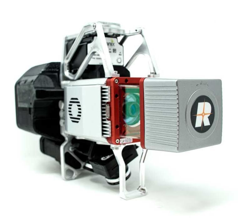
The True View 615 and 620 UAS lidar 3D imaging systems are compact, survey-grade sensors designed for small UAS. They are equipped with Riegl’s miniVUX-2UAV laser scanner integrated with dual photogrammetric cameras. Position and orientation is provided by an Applanix APX-15 (True View 615) or extreme accuracy APX-20 (True View 620). The systems are bundled with Applanix POSPac, True View EVO post-processing software and True View Reckon data-management solution. The system includes full post-processing software that generates a ray-traced 3D colorized point cloud and geocoded images.
Generates both survey-grade point clouds and high-resolution panoramas
The NavVis VLX wearable mapping system captures high-quality data in built environments such as construction sites, staircases and technical rooms. The compact, economical design enables high-quality data to be captured for architecture, engineering and construction (AEC) projects. Uses include conventional building documentation such as CAD drawings and BIM models, as well as web-based digital-twin solutions. NavVis VLX is equipped with two lidar sensors and captures survey-grade point clouds using the company’s SLAM technology, originally developed for the NavVis M6 indoor mobile mapping system. NavVis VLX also captures high-resolution panoramic images in a 360-degree field of view. The wearable device gives the operator more control over where the sensors are scanning. A built-in screen provides live feedback of what has been scanned and the quality of the data being captured.
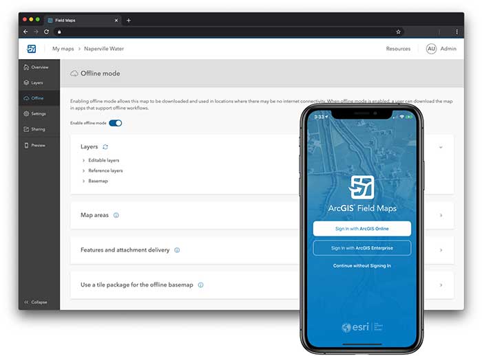
ArcGIS Field Maps, coming in September, will combine the following capabilities into a single app: map viewing and markup, high-accuracy field data collection and inspection, battery-optimized location tracking, work planning and task management and turn-by-turn navigation. Field Maps also will include a new web app, integrated with ArcGIS, that can be used to configure and deploy maps optimized for your mobile workforce needs, create and assign tasks to mobile workers, and create and share views of worker locations. ArcGIS Field Maps combines the functionality of five Esri ArcGIS mobile apps: Collector, Explorer, Tracker, Workforce and Navigator. Field Maps will also support the two formerly Collector-exclusive Eos solutions: Eos Locate and Eos Laser Mapping.
Blue Marble Geographics has released version 2.1 of its mobile mapping application Global Mapper Mobile, with updates to both the free and Pro versions.
Global Mapper Mobile is an iOS and Android application for viewing and collecting GIS data. It utilizes the GPS capabilities of mobile devices to provide situational awareness and locational intelligence for remote mapping projects.
A complement to the desktop version of Global Mapper, the mobile edition can display all of the supported vector, raster, and elevation data formats and offers a powerful and efficient data collection tool. The latest release includes improvements to its vector feature styling, terrain layer support, and layer transparency setting.
For advanced field mapping functionality, the latest release of the optional Pro version (available for purchase) introduces advanced GPS support. This allows users to connect to external, high-accuracy Bluetooth GPS devices from vendors such as Bad Elf and EOS, among others, directly from Global Mapper Mobile, allowing users to access detailed information including the current satellite constellation, precise location information and the raw NMEA stream.
“Global Mapper Mobile v2.1 brings exciting new functionality to the application, much of which was highly driven by user requests and feedback,” said Jeffrey Hatzel, senior application specialist at Blue Marble Geographics.
Blue Marble’s GIS software is used by hundreds of thousands of satisfied customers throughout the world who need affordable, user-friendly, yet powerful GIS solutions. Users come from a wide range of industries including software, oil and gas, mining, civil engineering, surveying, and technology companies, as well as government departments and academic institutions.
Visit the website to learn more and download Global Mapper Mobile v.2.1.
Cesium users now have access to Cesium OSM Buildings, a global base layer of more than 350 million 3D buildings.
Cesium OSM Buildings expands the suite of Cesium Global Base Layers including worldwide terrain, aerial imagery and streetmaps already available on Cesium ion.
“As digital twins and urban mapping gain momentum in 3D geospatial, we are excited to offer a global layer of 3D buildings that can be easily visualized, styled and analyzed in an efficient and interoperable manner using 3D Tiles,” said Cesium CEO Patrick Cozzi. “Cesium OSM Buildings will help geospatial developers innovate by giving urban context to 3D applications for a broad range of use cases.”
Cesium OSM Buildings are built for efficient visualization and are streamable to any device thanks to 3D Tiles, the OGC open standard developed by Cesium to stream massive 3D geospatial datasets. Adherence to open standards means the buildings can be used in any compatible viewer, including Cesium’s free open-source offering, CesiumJS.
Seattle’s Space Needle. (Image: Cesium)
“Cesium OSM Buildings will be useful for everyone from builders sharing planned construction projects, to government agencies seeking tools for planning, training, and simulation,” said Kevin Ring, lead developer on the project.
Cesium OSM Buildings are derived from OpenStreetMap, a community-driven mapping project that welcomes anyone to improve the dataset. Buildings are also regularly updated, firmly clamped to terrain, and are individually selectable and styleable.
“Thanks to the OpenStreetMap project, most cities contain rich metadata that is useful for on-the-fly styling, like highlighting hospitals in a certain color or filtering buildings by the year they were constructed,” Ring said.
Cesium OSM Buildings is included in every Cesium ion subscription.
Cesium is a complete platform that makes the world’s ever-growing collection of real-world 3D data more useful and accessible by enabling the creation of applications that visualize, analyze and share this data – all from your browser.
Rooted in the aerospace industry, Cesium was built to track satellites orbiting the Earth with sub-millimeter accuracy. Cesium continues to aggressively develop and enhance the platform for a range of customers in government agencies, startups and Fortune 500 companies alike.
A new monitoring system developed through an ESA-backed project works like a bodyguard for satellite navigation in use at strategic or safety-critical sites. Known as GIDAS, the scalable system immediately detects, identifies and pinpoints satnav interference sources in its vicinity.
It is estimated that there are currently the same number of satnav receivers on Earth as there are people. Positioning, navigation and timing signals from space-based constellations such as Galileo and GPS form an invisible, essential infrastructure, underpinning numerous modern aspects of modern life: communications, power and transportation.
Satellite navigation helps guide a growing number of aircraft, boats, trains and autonomous vehicles. Meanwhile satnav-based time stamps authentic multi-billion euro financial transactions, and coordinate the synchronised running of power grids. Satellite navigation is always on, available everywhere on Earth, so it is easy to take its availability for granted. But as crucial as these signals from space are, they are also vulnerable to ground-based interference.
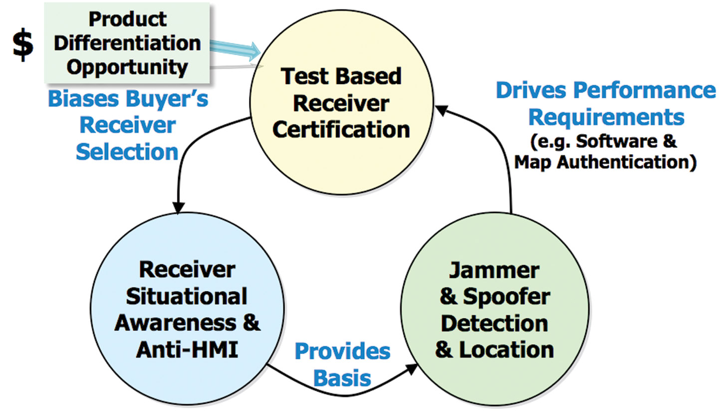
“It’s simply a matter of output power,” said Andreas Lesch of Austria-based OHB Digital Solutions. “A navigation signal on the ground is equivalent to the light from a 60-watt lamp aboard a satellite, some 23,222 km away in space in the case of Galileo. So these faint signals can be jammed by more powerful local radio signals, either accidentally or deliberately, or even misleading fake navigation signals, known as spoofing.”
“Our new GNSS Interference Detection and Analysis System, GIDAS, is designed to safeguard critical infrastructure against jamming or spoofing, by performing continuous monitoring of key signal bands. By doing so, GIDAS can raise the alarm in real time, identify the type of interference then pinpoint the location of these dangerous portable devices causing the interference so the authorities can take immediate remedial action.”
GIDAS can provide interference detection and directionality with a single reporting station, although a minimum of three stations are required for pinpointing interference sources, linked to an overall monitoring center. Monitoring centers can also be connected together, making the GIDAS system easily scalable, from safeguarding an individual harbour, airport or system critical site up to an entire city or region.
GIDAS can provide interference detection and directionality with a single reporting station, although a minimum of three stations are required for pinpointing interference sources, linked to an overall monitoring center. (Photo: ESA)
“People are only now catching up to the seriousness of this problem,” adds Andreas. “Surveys of the highest-density parts of Europe surveys report around three to four jammers hourly.
“These small devices are technically illegal but are easily available online for a few hundred euros or less, often marketed as personal privacy devices. Jammers are sold as having a range of only a few metres, but can turn out to have a practical range of dozens of metres or more — leading to unintentionally widespread interference, like the famous jammer-equipped U.S. truck driver who shut down Newark Airport navigation systems whenever he drove past.
“Spoofing is more serious still, with a strong criminal element, where false satellite navigation signals replace real ones, to mislead receivers about their position, employed in the past to down put drones or divert boats.
“Working in this field for eight to nine years, we have seen a strong growth in interference, even as GNSS becomes ever more crucial. With our passion for GNSS and signal processing, we decided to something practical to combat this development, delivering rapid detection, classification and localisation of interference to our customers.”
GIDAS was developed by OHB Digital Solutions and Joanneum University through ESA’s Navigation Innovation and Support Programme (NAVISP), working with European industry and academia to develop innovative navigation technology.
“The company initiated the project through NAVISP’s second element, focused on strengthening European competitiveness in the navigation arena, proceeding on a co-funded basis,” said engineer Thomas Burger, overseeing GIDAS project for ESA. “The plan was to enable a commercially attractive business to get started, and I’m happy to say we made it.”
“Considering the budget, the project had a wide scope, including the development of a multi-constellation GNSS receiver with all processing stages, an extended digital front end for jamming and spoofing detection, processing blocks transferred to a parallel processor based on a customised fully programmable gate array.
“And that was only one ingredient of the overall GIDAS system, also including the actual interference detection machinery, the interference locating subsystem, and all the communication, database, and graphical user interface elements needed to create a distributed, human-usable system — which is able to go on working autonomously, only asking for human involvement when events are detected.”
Now that its two-year NAVISP project has concluded, GIDAS is now being rolled out to several Europe-based governmental and private sector customers.
Following the announcement that ION GNSS+ 2020 will be virtual only this year, GPS World has decided to cancel this year’s Leadership Dinner and Awards Ceremony, which would’ve been held Sept. 24 in St. Louis.
The GPS World Leadership Dinner and Awards Ceremony is held annually at the time of (although separately from and independent of) the ION GNSS+ conference. Four innovators in the fields of satellites, signals, services and products are honored with awards in front of an audience of nearly 150 PNT industry and research community VIPs.
“This was not a decision we took lightly as so many of us look forward to wrapping up the conference by honoring deserving colleagues over a nice meal followed by a fun activity,” said Marty Whitford, GPS World’s group publisher and editorial director.
The non-profit 211 LA County and Slingshot Aerospace have unveiled an online mapping tool that allows users to quickly identify and locate more than 2,000 food resources within the county during and after the COVID-19 pandemic.
211 LA County is a non-profit organization providing the official information and referral source for health and human services in LA County. Slingshot Aerospace is a situational intelligence platform company,
The customized tool, called 211 LA FoodFinder, is powered by Slingshot Earth and is the biggest and only food map that allows LA residents to search for resources by location and view services specific to seniors, children and others, enabling individuals to find aid near them faster. Resources within the FoodFinder are free, with the exception of those with suggested donations or delivery service fees.
LA County residents will be able to identify different types of available food resources, such as child nutrition, meal services, groceries/food pantries, senior food needs and government food benefits programs.
The platform also provides location details, hours of operation and contact information for each of the services. 211 LA County is currently experiencing a tenfold increase in website traffic related to food resources compared to pre-COVID timeframes.
The organization anticipates the robust application to service nearly 30,000 LA County constituents over the next quarter, many of which may not have prior experience with food assistance.
“Food resources are the biggest need people are contacting us about since the COVID-19 pandemic hit LA County,” said Maribel Marin, executive director, 211 LA County. “With so many people out of work, the need for food is going to get progressively more intense, but people shouldn’t worry because there are lots of resources and ways to access them. Our custom Slingshot Earth food locator provides our community with a one-stop-shop for food resource information, helping to provide peace of mind to those who need food assistance during this unprecedented time.”
211 LA County’s customized Slingshot Earth mapping tool aggregates food resources and service data from multiple public and private sources so that individuals have the right information, at the right time, all in one place. The data is verified and updated regularly to ensure that Los Angeles County residents have the most up to date information as guidelines and offerings continue to evolve.
“This work to help 211 LA County provide critical food service information in our community is so meaningful to us because we are driven by a vision to create a safer, more sustainable world,” said Mel Stricklan, Co-Founder and Chief Strategy Officer, Slingshot Aerospace. “Our business was founded on the idea that information is power, especially in complex situations. The COVID-19 pandemic is uncharted territory for all of us, and we are happy to do our small part in navigating these tough times by providing essential information to those who need it most.”
By Airman 1st Class Jonathan Whitely, 50th Space Wing Public Affairs
News from Schriever Air Force Base
The 2nd Space Operations Squadron performed the first station keeping maneuver on a GPS III satellite to Satellite Vehicle Number 75 on May 14 at the Schriever Air Force Base in Colorado.
The maneuver set a new standard for how GPS maneuvers should be conducted for the squadron that provides precision, navigation and timing signals to billions of users around the world.
A station keeping maneuver is performed to keep vehicles in their node (or parking spots in orbit) and involves burning the satellite’s thrusters and changing the vehicles speed at a particular point in its orbit. This causes the orbit to change, in turn, keeping the vehicle in the ideal position to provide coverage.
“All operational GPS vehicles are assigned nodes, when all nodes are filled with healthy vehicles there is good global GPS coverage,” said 1st Lt. Michael Gallagher, GPS subsystems analyst. “When new vehicles are launched they typically aren’t launched directly into their final node. This means that the 2 SOPS analysis flight must perform a re-phase maneuver to put a vehicle in its node.”
The maneuver required GPS III’s signal to be turned off. Turning off the navigation signal while performing the maneuver prevents users from receiving inaccuracies generated by a change in satellite velocity.
“This was a new process that we could learn from as it was the first station keeping [maneuver] performed for the newest generation of GPS satellites,” said Senior Airman Harrison Sherwood, 2 SOPS satellite systems operator, who sent the commands to the satellite during the maneuver. “[Since] this was the first [maneuver] of the newest generation satellites, it was a bit of a guinea pig for future maneuvers.”
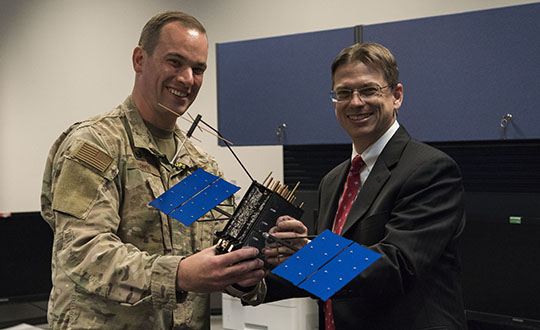
Johnathon Caldwell, Lockheed Martin Space vice president of navigation systems, right, presents Lt. Col. Stephen Toth, 2nd Space Operations Squadron commander, with a GPS III model satellite as a token of appreciation for the 2nd SOPS critical mission in space at Schriever Air Force Base, Colorado, July 29, 2019. The squadron performed its first station keeping maneuver on a GPS III satellite May 14, 2020, at Schriever AFB. (Photo: U.S. Air Force/1st Class Jonathan Whitely)
However, the unit was able to complete the maneuver flawlessly. The maneuver was completed in a special mission area and there were no changes to the normal operations floor.
“This maneuver had no effect on the rest of the [GPS satellite] constellation,” Gallagher said. “SVN-45 was in the node SVN-75 was being placed into, so there was no decrease in GPS signal quality as a result of this maneuver.”
This procedure was also the first of its kind to be performed with the 2nd SOPS Architecture Evolution Plan, which all active satellites in the program are operated. Since GPS III vehicles are fully integrated into the program with this maneuver, all maintenance is conducted through AEP.
“Station keeping maneuvers are essential to satellite operations and must be done for regular maintenance,” said 2nd Lt. Tyler Gorman, 2nd SOPS navigation payload engineer. “This activity helped validate a nominal maintenance activity for a new generation of vehicles.”
The unit plans to continue to use this new method and program for future GPS satellites that are being launched and need to be re-phased into their operation slots. The next satellite that will need a station maneuver performed is SVN-76, which is scheduled to launch in the next few months.
“GPS maintenance requires a coordinated effort to ensure our worldwide service is preserved,” Gorman said. “That means careful planning and execution from our analysts in 2 SOPS, our satellite system operator and the operational support from Lockheed Martin and the Aerospace Corporation.”