L3Harris Technologies will help the U.S. Department of Defense (DOD) develop artificial intelligence and machine learning (AI/ML) systems to help reduce the amount of time it takes to decipher usable intelligence from increasing amounts of data collected from space and airborne assets.
L3Harris will research, develop and demonstrate an AI/ML interface using data science techniques under a new multimillion-dollar contract to support DOD applications.
“L3Harris’ work will allow the DOD to turn massive volumes of data into actionable intelligence,” said Ed Zoiss, president, Space and Airborne Systems, L3Harris. “The abundance of data collected by space and airborne assets is only increasing. The findings of this research will directly address the data processing challenges within the DOD and intelligence community.”
Awarded by the U.S. Army Research Laboratory, the contract supports the DOD’s initiative to accelerate the integration of big data and AI/ML within the agency.
L3Harris will perform the work in Rochester, New York; Melbourne, Florida; and Herndon, Virginia.
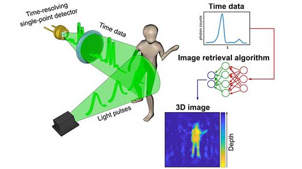
A new method of imaging that harnesses artificial intelligence to turn time into visions of 3D space could help cars, mobile devices and health monitors develop 360-degree awareness.
Photos and videos are usually produced by capturing photons with digital sensors. 3D images can be generated either by positioning two or more cameras around the subject to photograph it from multiple angles, or by using streams of photons to scan the scene and reconstruct it in three dimensions. Either way, an image is only built if spatial information of the scene is gathered.
Now, researchers based in the United Kingdom, Italy and the Netherlands describe how they have found an entirely new way to make animated 3D images — by capturing temporal information about photons instead of their spatial coordinates. The team’s paper, “Spatial images from temporal data,” was published in Optica.
Their process begins with a simple, inexpensive single-point detector tuned to act as a kind of stopwatch for photons. Unlike cameras, which measure the spatial distribution of color and intensity, the detector only records how long it takes the photons produced by the split-second flash of a pulse of laser light to bounce off each object in any given scene and reach the sensor. The farther away an object is, the longer it will take each reflected photon to reach the sensor.
The information about the timings of each photon reflected in the scene — temporal data — is collected in a simple histogram. Those graphs are then turned into a 3D image using a sophisticated neural network algorithm. The researchers “trained” the algorithm by showing it thousands of conventional photos of the team moving and carrying objects around the lab, alongside temporal data captured by the single-point detector at the same time. Eventually, the network learned enough about how the temporal data corresponded with the photos that it was capable of creating highly accurate images from the temporal data alone.
In the proof-of-principle experiments, the team managed to construct moving images at about 10 frames per second from the temporal data, although the hardware and algorithm used has the potential to produce thousands of images per second.
Alex Turpin, a Lord Kelvin Adam Smith Fellow in Data Science at the University of Glasgow’s School of Computing Science, led the university research team with Prof. Daniele Faccio and support from colleagues at the Polytechnic University of Milan and Delft University of Technology.
“Cameras in our cellphones form an image by using millions of pixels,” explained Turpin. “Creating images with a single pixel alone is impossible if we only consider spatial information, as a single-point detector has none. However, such a detector can still provide valuable information about time. What we’ve managed to do is find a new way to turn one-dimensional data — a simple measurement of time — into a moving image that represents the three dimensions of space in any given scene.”
After data collection, 3D images are retrieved from the temporal histograms. (Image: University of Glasgow)
The approach is capable of decoupling light altogether from the image-capture process, and the paper discusses how the team managed to use radar waves for the same purpose. “We’re confident that the method can be adapted to any system which is capable of probing a scene with short pulses and precisely measuring the return ‘echo.’”
Right now, the neural net’s ability to create images is limited to what it has been trained to pick out from the temporal data of scenes created by the researchers. But with further training and by using more advanced algorithms, it could learn to visualize a range of scenes, widening its potential applications in real-world situations.
“The single-point detectors that collect the temporal data are small, light and inexpensive, which means they could be easily added to existing systems like the cameras in autonomous vehicles to increase the accuracy and speed of their pathfinding,” Turpin said. “Alternatively, they could augment existing sensors in mobile devices like the Google Pixel 4, which already has a simple gesture-recognition system based on radar technology. Future generations of our technology might even be used to monitor the rise and fall of a patient’s chest in a hospital to alert staff to changes in their breathing, or to keep track of their movements to ensure their safety in a data-compliant way.”
Next, the team will work on a self-contained, portable system-in-a-box as well as examining options for furthering research with input from commercial partners. The research was funded by the Royal Academy of Engineering, the Alexander von Humboldt Stiftung, the Engineering and Physical Sciences Research Council (ESPRC) and Amazon.
Citation. A. Turpin, G. Musarra, V. Kapitany, F. Tonolini, A. Lyons, I. Starshynov, F. Villa, E. Conca, F. Fioranelli, R. Murray-Smith, and D. Faccio, “Spatial images from temporal data,” Optica 7, 900-905 (2020), https://doi.org/10.1364/OPTICA.392465.
Telematics company SkyBitz has announced a strategic technology partnership with fleet logistics solutions provider Coretex. The partnership combines Coretex sensor-based refrigeration solution and cloud-based software platform with SkyBitz trailer tracking technology to create a complete solution for businesses needing both powered and non-powered asset tracking.
With the partnership, food, pharmaceutical and retail customers can have total visibility into the status of loads during transportation, resulting in improved food safety and quality assurance.
The SkyBitz and Coretex partnership allow customers to access and manage both reefer device data and trailer tracking data via one seamless solution, enabling greater insight, a more transparent view of their entire cold chain operation, and better decision making. Customers can now automate Food Safety Modernization Act (FSMA) compliance, allowing them to keep assets on the road for longer, monitoring them with advanced temperature tracking capabilities.
“Our customers look to us for innovative, value-driven solutions that help improve profits across their entire operation,” states Henry Popplewell, DVP and president of SkyBitz. “As leaders in the supply chain and logistics arena, we are excited to capitalize on this partnership to continue to grow our cold chain customer base and align ourselves with the foodservice industry through this technology partnership. The Coretex pedigree in last-mile food and beverage distribution is the perfect complement to our asset management technology.”
With this new offering, customers of Coretex and SkyBitz will benefit from the following:
More than 50 features of remote cold chain monitoring capabilities, including two-way reefer control, monitoring of up to six doors, and advanced power management to preserve reefer and telematics unit battery life.
Single point of access to critical and timely best-in-class trailer utilization and reefer information on one seamlessly connected platform, greatly expanding productivity and streamlining operations.
Communication between the trailer and other connected sensors with options to expand to additional Coretex products such as assurance solution CoreTemp.
An unmatched compilation of integrated driver safety, compliance, and asset management tools including the Coretex integration with trailer braking solutions and automatic tire inflation systems.
“Combining SkyBitz leading trailer and asset management technology with Coretex cloud-based software platform, two-way reefer solutions, and deep compliance capabilities create a powerful solution for both companies,” said Coretex CEO Selwyn Pellett. “At Coretex, reefer solutions have been a core part of our business for 16 years, and we’re excited to share our experience with SkyBitz. The trailer expertise of SkyBitz complements our offering, perfectly creating a solution that can help businesses increase the productivity of their assets. With the growing importance of food safety assurance for both food producers and distributors, we think both companies’ customers will find our combined fully-featured solution the best on the market.”
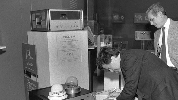
Feature image: Smithsonian; Charlie Trimble provides the 4000A GPS Locator to the Smithsonian Museum. Introduced in 1984, the Trimble 4000A was the first commercial GPS positioning product.
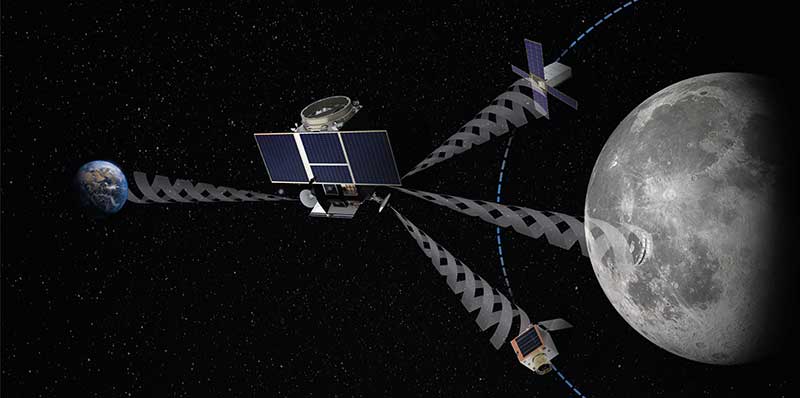
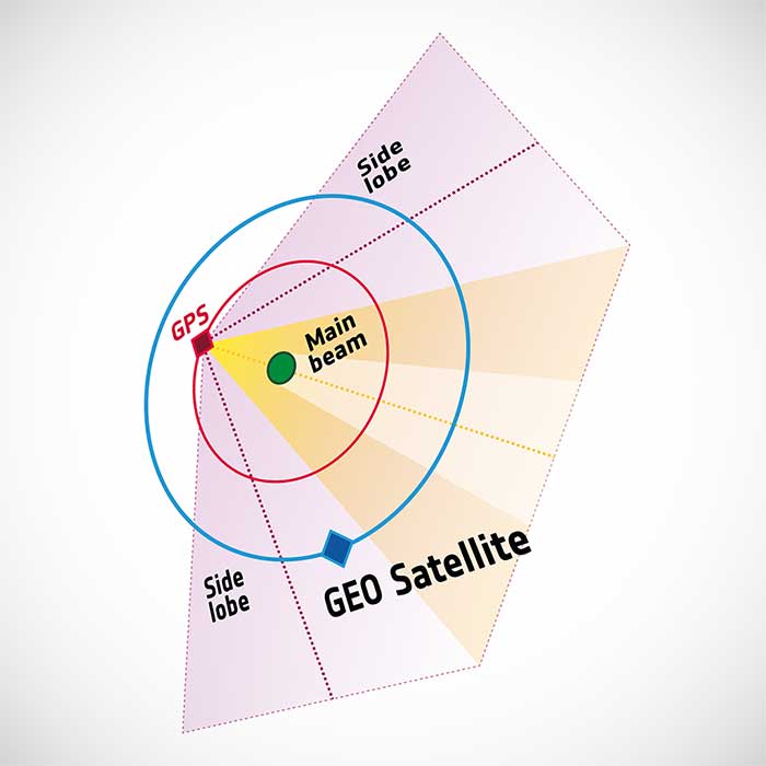
To pinpoint a location accurately, a receiver — in smartphones or on a spacecraft — needs to collect and combine signals from at least four navigation satellites. The receiver determines its distance from each of the satellites by measuring the time that it takes for the signal to travel from the satellite to the receiver.
Navigation satellites aim their antennas directly at Earth. Satellites orbiting above the navigation (GPS in this image, but Europe’s own navigation system is Galileo) constellation could only hope to detect signals from Earth’s far side. Now spacecraft can make use of signals emitted sideways from navigation antennas, within what is known as “side lobes.” Just like a torch, they shine energy to the side as well as directly forward.
Navigation satellites orbit 22,000 kilometers above Earth’s surface. As they point in the direction of Earth, any spacecraft between them and Earth are served well by their signal. But around 10 years ago, engineers started demonstrating that spacecraft outside the orbit of navigation satellites could also navigate in space using “spill over” signal from the satellites.
Then in 2012, two discovery and preparation studies explored a seemingly radical question: could this spillover signal even be used to navigate our way around the moon, and if so, what kind of receiver would we need to build to be able to use these signals?
The studies found that the signal from navigation satellites orbiting Earth could be used to navigate the moon’s surface. But with the signal being so weak, they found that a new type of receiver would need to be built, and at the time there was no clear application for this.
Eight years later, ESA invested in the development of such a receiver, and is exploring whether it could be demonstrated on the Lunar Pathfinder mission. ESA is collaborating with Surrey Satellite Technology Ltd. and Goonhilly Earth Station on this mission, which will provide exciting new opportunities for science and technology demonstration. In particular, it will help lay the groundwork for providing navigation services around the moon, currently studied through two ESA NAVISP activities and culminating in the Moonlight initiative.
“We have now accurate simulation results that show that navigation signals may be used at moon orbit and provide good performances,” said Dr. Javier Ventura-Traveset, head of the Galileo Science Office and in charge of coordinating all GNSS moon activities for ESA’s Navigation Directorate. “And with an innovative receiver in Lunar Pathfinder, we could have the first ever experimental evidence of this.
Artist’s impression of the Lunar Pathfinder mission. (Image: SSTL)
“Furthermore, we are also studying how existing navigation constellations may be complemented by additional moon-orbiting satellites, providing additional ranging signals for an optimal navigation service including moon landing and moon surface operations. This is being done as part of the ESA NAVISP program and through the ESA Moonlight initiative.”
“The discovery and preparation studies have been eye-openers and they are currently being followed up by a NAVISP activity aiming to develop the highly sensitive spaceborne navigation receiver planned to fly on board Lunar Pathfinder,” said ESA Radio Navigation Engineer Pietro Giordano. “This technology will enable improved performances and much more cost-effective ways to navigate and operate missions to and around the moon.”
The COVID-19 pandemic has brought uncertainties to all businesses, and the mapping industry has been no exception.
Slowdowns were observed during the first few months of 2020 as lockdowns were gradually enforced in Asia, then Europe, and finally the Americas.
As expected, projects were delayed during that initial period as companies were reorganizing their operations to allow for remote work.
Once that transition was overcome, a great number of projects resumed, and the geospatial field has been gradually coming back to normal since then. That can be explained by different factors, including, for example, several governments accelerating infrastructure projects to stimulate the economy.
A lot of mapping firms have turned the pandemic into an opportunity to improve their processes. Slower times allow reviewing production workflows and assessing bottlenecks. Once identified, new hardware and software solutions can be evaluated to optimize production.
Interestingly, the resulting investments into new solutions has been significant. Companies are seeing a quick payoff as their workload is rapidly accelerating, leading to an increase in their bottom line.
Overall, the mapping industry was able to rapidly adjust to the new reality caused by the pandemic. The changes that are being made in performing projects not only allow us to minimize risks in the short term, but also to increase profitability in the longer term.
SimActive is the developer of Correlator3D software, a patented end-to-end photogrammetry solution for the generation of high-quality geospatial data from satellite and aerial imagery, including drones. Correlator3D performs aerial triangulation (AT) and produces dense digital surface models (DSM), digital terrain models (DTM), point clouds, orthomosaics, 3D models and vectorized 3D features.
Powered by GPU technology and multi-core CPUs, Correlator3D ensures high processing speed to support rapid production of large datasets.
SimActive has been selling Correlator3D to leading mapping firms and government organizations around the world, offering cutting-edge photogrammetry software backed by exceptional customer support.
New process simplifies task of computational geospatial processing accessible via web services
The Open Geospatial Consortium (OGC) seeks public comment on a new draft OGC API standard: OGC API – Processes – Part 1: Core. Comments are due by Oct. 19.
The draft OGC API – Processes Standard specifies a Web API that enables the execution of computing processes and the retrieval of metadata describing their purpose and functionality. For example, these processes could combine raster, vector, coverage and/or point cloud data with well-defined algorithms to produce new raster, vector, coverage and/or point cloud information.
The draft OGC API – Processes Standard builds on the Web Processing Service (WPS) 2.0 standard and defines the processing standards to communicate in a RESTful manner using JSON encodings. This API is a newer and more modern way of programming and interacting with resources over the web while allowing better integration into existing software packages.
In many cases, location data, including data from sensors, must be processed before the information can be effectively used. OGC API – Processes, just like the OGC WPS Interface Standard, provides a standard interface that simplifies the task of making simple or complex computational geospatial processing services accessible via web services.
Such services include well-known processes found in GIS software as well as specialized processes for 2D/3D/4D modeling and simulation. The API also makes it easy for developers to implement microservices that can handle location data.
The draft OGC API – Processes Standard provides a similarly robust, interoperable, and versatile protocol for process execution across the Web. OGC API – Processes supports both immediate processing for computational tasks that take little time and asynchronous processing for more complex and time-consuming tasks.
As with other OGC APIs, OGC API – Processes consists of optional parts that each provide extra functionality. This specification, Part 1: Core, is intended to be a minimal useful API for the execution of processes from the geospatial domain. There are no constraints on the types of processes that can be published through the API. Examples of processes that have been demonstrated during the development of the draft API standard include routing, contour generation, buffering, coverage processing and several others. The API is therefore expected to be applicable to several domains.
Terrain Painting in Global Mapper v22. (Image: Blue Marble)
Blue Marble Geographics has released version 22 of Global Mapper along with an upgrade to the accompanying Lidar Module.
Global Mapper GIS software provides both novice and experienced geospatial professionals with a comprehensive array of spatial data processing tools, with access to a variety of data formats.
Among other features, Version 22 includes
Eye Dome Lighting settings in the 3D viewer to help improve the visual display of vector and lidar data
a new tool for simplifying meshes or TINs
a new Spatial Operations tool for analyzing the relationship between overlapping vector features
a new option to measure the overlap between two or more lidar, raster/image and terrain layers
a new consolidated Digitizer Menu providing convenient access to all drawing and digitizing tools
The Lidar Module, an optional add-on to Global Mapper, provides advanced point cloud processing tools, including Pixels to Points for photogrammetric point cloud creation using overlapping drone-captured images, automatic and manual point cloud classification, feature extraction, hydro-flattening, and more.
Terrain Paint tool. The upgraded Lidar Module includes a new Terrain Paint tool for manipulating elevation values in a freeform way, a new algorithm to improve building classification results, improved building extraction with better 3D shape simplification for generating building footprints, a new option to create a process summary report when using the Pixels to Points process, dramatically faster rendering of lidar path profiles with a large number of points, and more.
“The version 22 release illustrates Global Mapper’s rapidly expanding geospatial footprint,” stated Blue Marble’s President, Patrick Cunningham. “In this one release cycle, we have introduced countless new tools for GIS analysis.Global Mapper is truly an accessible yet powerful GIS platform. As always, we are pleased to be able to bring all of these capabilities together in one GIS platform while keeping the price affordable.”
Blue Marble Application Specialists will hold a webinar Sept. 30 to showcase Global Mapper v22. This presentation is scheduled to begin at 2:00 pm (U.S. Eastern Time), and it will allow attendees to see the latest tools and ask questions about the new functionality. Registration is required.
London building-design agency DCSK is using 3D building models from Bluesky to inform the design of high-profile urban residential developments.
Derived from the most up-to-date and accurate aerial photography, the Bluesky 3D models allow DCSK to place a design within its real-world context, consider sensitive view and vantage points, and communicate ideas to clients, planning authorities and the public.
DCSK has used a number of models from Bluesky, including a detailed representation of central Birmingham for the design of a 24-storey student accommodation on Lancaster Street.
“We have always had to consider how a design sits within the existing cityscape and how it will interact with the buildings and infrastructure that surround it,” said James Khamsi, Director of DCSK. “Before geographically accurate computer representations, such as the Bluesky 3D models, were available and affordable, we relied on a combination of site photographs and traditional 2D maps. This was a crude workflow that raised potential concerns about the currency and accuracy of information that was informing both the design and resulting planning permissions.”
DCSK is using 3D models from Bluesky for projects such as Curzon Circle Student Accommodation and others.Photogrammetrically derived from stereoscopic aerial photography, the Bluesky models are fully rendered and are provided as either wireframe or block models in a format suitable for use in both CAD and GIS software.
All Bluesky 3D models are supplied with a digital terrain model (DTM) depicting the topography of the underlying surface.
DCSK imports the Bluesky data into its 3D modelling software Rhino, where it is used to create a background layer for the design. The development site is isolated, and this data removed from the background layer, allowing for the detailed design to be dropped in. The proposed development can then be viewed and analyzed in its real-world context with detailed assessments of access ways and viewpoints, for example.
“The Bluesky models allow us to inhabit the site and experience the design as if we were there,” said Khamsi. “We can explore potential sensitivities, and, as the models are agile, we can massage the design exploring different options without leaving the office. The Bluesky models are also intuitive and therefore easy to interpret allowing us to communicate complex design ideas.”
Mobile GIS Services (MGISS) has been awarded a place on the United Kingdom government’s procurement platform G-Cloud.
Designed to ease the procurement of cloud services by the public sector, the G-Cloud 12 framework makes it easier for customers to find, review and contract MGISS’s advanced geospatial software services through an online digital marketplace. Managed by Crown Commercial Services, it is forecast that successful suppliers, such as MGISS, will receive up to £2 billion in business.
In a parallel achievement, MGISS has also been accredited as a supplier of software, hardware and support services to the utility sector by the supplier assurance company Achilles.
A specialist in mapping and geographic information technology, MGISS also is working alongside organizations such as United Utilities and Northumbrian Water Group and it is hoped that successful qualification under the Achilles UVDB pre-qualification system will help MGISS gain further traction within this sector.
MGISS has also attained the Workplace Wellbeing Charter. Recognizing a commitment to improving the lives of its team members, MGISS received accreditation across a number of facets including leadership, health and safety, mental health and absence management.
“Although recognizing completely different aspects of the business these awards are all significant milestones and accomplishments in their own right and the entire team should be proud of the hard work and commitment they have expended to achieve them,” said MGISS Managing Director and Founder Mike Darracott. “The G-Cloud and Achilles accreditation will put MGISS front and center for the leading players within the public and utility sectors and this will help us capitalise on our work to date with organizations such as Surrey County Council and Wales and West Utilities.
“The Workplace Wellbeing Charter not only recognizes our existing commitment to the health and wellbeing of our team it also gives a benchmark to work from and a toolset to work with to continuously improve,” he continued, “and a happier and healthier workforce will, we hope, make the business even better and stronger.”
Firm will provide geophysical surveying services across multiple states
Dewberry, a privately held professional services firm, has been awarded multiple task orders from the U.S. Geological Survey (USGS) under the Geospatial Products and Services Contract (GPSC) to perform airborne geophysical surveys in portions of Missouri, Illinois, Kentucky, Texas and New Mexico for the USGS Earth Mapping Resources Initiative (Earth MRI).
“Earth MRI is a play on words, as people are familiar with the use of magnetic resonance imaging (MRI) to image inside the human brain,” said Dewberry Project Manager David Maune. “Dewberry is excited to support USGS in its mission to assess critical minerals using airborne geophysical survey technology.”
Dewberry will perform very low-altitude magnetic and radiometric surveys from a fixed-wing aircraft and a helicopter with towed-array sensors to image subsurface geologic structures in search of undiscovered critical minerals and rare earth elements vital for the electronics industry.
These projects, which will be used to evaluate the potential for undiscovered critical mineral deposits contributing to an understanding of the major mineral systems for the two regions, are expected to be completed in early 2021.
Esri has released a new mapping app, Air Quality Aware, that fuses data from the EPA’s AirNow program, NOAA’s National Weather Service wind forecast and the American Community Survey to provide location intelligence on current air quality and its impacts on local communities.
At a national level, areas are color-coded according to EPA’s Air Quality Index, with magenta and purple representing hazardous and very unhealthy air quality.
As users zoom in, the map shows the air-quality scores reported at each individual air-quality monitoring station.
Users can click on any station for more information about the pollutants and concentrations reported at that location. They can also search for or click any place on the map to get more information about current and forecasts of air quality, wind speed and insights about the vulnerable population in each place.