Topcon Positioning Group announces a new partnership with digital photogrammetric solution provider Agisoft LLC. The agreement is designed to further expand the Topcon solutions portfolio for mass data collection (MDC).
Agisoft is a world leader in the processing of digital imagery in order to generate high-accuracy 3D spatial data using photogrammetric and computer vision techniques, and has been developing imaging solutions for nearly 10 years. Topcon will provide the Agisoft Photogrammetric Kit for Topcon — Professional Edition software for post-processing of data collected using the Falcon 8 and Sirius Pro unmanned aerial systems (UAS).
Features include photogrammetric triangulation, dense point-cloud editing and classification, digital terrain or surface model export to a variety of formats including georeferenced orthomosiac production (including GeoTIFF and KML export), multi-spectral imagery processing, 3D model generation and texturing, as well as full measurement analysis tools.
“We are very excited to be able to offer the combination of our Sirius Pro and Falcon 8 UAS devices and Agisoft Photogrammetric Kit Professional software. The solution provides an integrated workflow for reaching high-accuracy survey results using unmanned aerial systems with minimal field work,” said Eduardo Falcon, executive vice president and general manager for the Topcon GeoPositioning Solutions Group. “For example, when using the Sirius Pro, absolute accuracies down to 1.6 cm (0.6 in.) in plan and 2.7 cm (1 in.) in height are possible without the need for any ground control.”
Fugro has been awarded a three-year contract by PGS for the provision of precise satellite positioning systems for its seismic vessel fleet. PGS is a leading global provider of marine seismic and electromagnetic services, data acquisition, imaging, reservoir services and multi-client library data.
Fugro, provider of precise satellite positioning to the offshore oil and gas industry, will supply PGS vessels with a number of independent GNSS. These systems include Fugro’s recently launched Starfix.G4 — a commercial GNSS service to utilize all available GNSS systems (GPS, GLONASS, Galileo and BeiDou), giving sub-decimeter accuracy — and Starfix.G2+, a global service offering centimeter accuracy in both position and height.
In addition to precise vessel positioning, PGS will benefit from a new generation of positioning technology for their seismic sources and tailbuoys. Meeting the high demand for robustness and quality in the offshore industry, this proactive technology provides independent decimeter and centimeter positions and heights for remote (seismic source and tailbuoy) operations.
Cerys James, vice president technical at PGS, remarked, ”Reliable, precise positioning technology is essential for modern seismic operations. The solution supplied by Fugro will ensure our entire fleet has highly accurate vessel positioning, along with precise source and streamer positioning.”
Coming to a store near you: Wi-Fi’s unparalleled reach means it will locate shoppers
Marketing graphic for Cisco Mobile Concierge shows retail businesses how to engage with their customers “in a targeted contextual manner through their mobile devices within specific venues… Customers can now receive relevant information based on their location” within the store. (Courtesy of Smart Wi-Fi Systems)
Wi-Fi indoor location application revenues will reach $2.5 billion by 2020, according to a report from ABI Research. Wi-Fi Indoor Location Applications and Revenues was released in Q4 2015.
“Wi-Fi, as an indoor location and analytics tool, is in a very precarious position,” said Patrick Connolly, Principal Analyst at ABI Research. “Apple continues to create roadblocks, while Bluetooth low-energy (BLE) beacons have not only taken mindshare but also budgets. However, Wi-Fi is ubiquitous on smartphones and available in over 50 percent of major retail stores in the U.S., giving it unparalleled reach. Previously, it was an expensive and inaccurate technology, but Wi-Fi access point vendors like Zebra and Cisco have all upped their game on retail analytics, while start-ups like Euclid have helped to drive adoption worldwide.”
Wi-Fi’s superior penetration means it is a much better technology than BLE beacons for in-store analytics today, according to ABI. While location-based advertising is stealing the headlines, retailers are finally waking up to in-store analytics, which represent a major evolution on people counting and loyalty programs. This data will streamline store layouts, improve staff management, measure advertising campaign performance, enhance loyalty/reward programs, and form the backbone of new smartphone services.
One company active in this space, Cisco Mobil Concierge, promotes its location capabilities for retail, hotels, transport hubs, museums and more. Its Mobility Services Engine API offers such services as “track-and-trace interferers, rogues, Wi-Fi clients and RF tags; Geofencing and zone-based alerts; Thinksmart Localtion Analytics.”
The latter software suite offers such data as shopper cluster points, dwell times, typical paths and crowding. From the shopper’s viewpoint, the experience begins when a smartphone automatically discovers the venue’s services; a “service available” and a media-access-control service access point (MSAP) pops up. The user clicks on the MSAP icon to view a list of services and can opt in to be tracked within the venue, presumably in exchange for special offers.
According to Cisco, this means “new experiences, new revenue and opportunities for businesses everywhere.”
Russian Space Systems (RCC) has completed work on the GLONASS navigation system, passing its final tests for the customer, the Russian Ministry of Defense, reports the TASS news agency.
The system has not yet been formally adopted by the Ministry of Defense, and remains in the research and development phase, RCC CEO Andrew PKC Tyulin the told the Izvestia newspaper.
“We presented the system to the customer for final tests, which are coming now,” Tyulin said. “During the tests, the customer gave us some comments, which we addressed, and Nov. 5 tests were resumed.”
He said every effort is being made to complete the work. “We hope that the results of the test system will be put into operation. ”
Positioning and heading for mission-critical applications
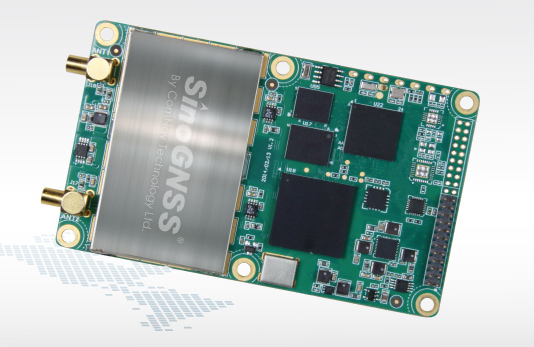
The K528G dual-frequency, multi-constellation GNSS board provides the highest accuracy in differential positioning. It benefits from numerous constellation signals because of its advanced tracking performance of both GPS and GLONASS. The K528G can provide positioning and heading information generated by two antennas. It is designed for guiding and positioning construction engines, dredges, barges, shipping container cranes, mining equipment and intelligent transportation systems.
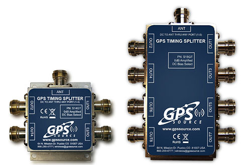
Designed for small-cell and distributed antenna systems
GPS Source has released of a line of GPS/GNSS splitters created for the small-cell wireless and distributed antenna system markets. Specifically designed for the L-band frequency, they can eliminate the cost of multiple antennas and long cable runs in wireless installations. With four or eight outputs, the new line of splitters make it possible to use a single GPS referencing antenna and cable arrangement for multiple synchronized systems. The splitters include features such as DC bias select and amplification. GPS Source RF signal splitters typically operate in conjunction with an active GPS antenna; consequently, a GPS RF signal splitter must have provisions for managing the DC voltage to the active GPS antenna. The S14GT and S18GT splitters will power an external GPS antenna from any of the RF outputs. A “hunt-and-pick” circuit is used to select only one DC input for power should more than one source be connected. Designed for redundancy, if the selected DC bias input should fail, the DC bias will automatically switch to another DC input to ensure an uninterrupted power supply to the active antenna.
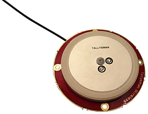
For precision industrial, agricultural and military OEM applications
A new series of L1 band wideband antennas for OEM applications is offered in three formats:
▪ TW2106/TW2108 — GPS L1
▪ TW2406/TW2408 — GPS + GLONASS
▪ TW2706/TW2708 — Galileo, BeiDou, GPS + GLONASS
Each antenna type features Tallysman’s Accutenna technology, which provides high rejection of multipath signals, with low axial ratios and tight phase center variations (PCV). Each is available with a brickwall pre-filter option to protect against saturation by high level subharmonic and L-band signals. The antenna printed circuit boards (PCBs) are 56 millimeters in diameter with four plated holes for secure mounting. They are available with a variety of connectors and custom cable lengths, and can be custom-tuned. All of them are REACH and ROHS compliant.
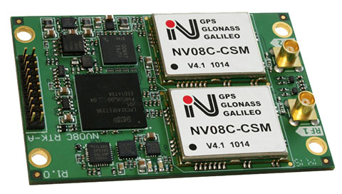
The NV08C-RTK-A is fully integrated multi-constellation L1 heading receiver with embedded real-tiime kinematic (RTK) functionality and compatibility with GPS, GLONASS, Galileo and BeiDou. The NV08C-RTK-A is designed for use in high-accuracy applications that demand low-cost, low-power consumption, a small form factor and high performance, such as construction, mining and industrial; environmental and structural monitoring; machine control; parallel driving systems; precision agriculture; UAVs; and robotics and intelligent machines.
The SLD-100 GNSS Rover accessory facilitates hydrographic measurement in bodies of water up to 100 meters in depth. it is designed for anyone who finds themselves needing to survey into bodies of water, streams and rivers. With survey-grade accuracy, the SLD-100 can be added to any brand GNSS RTK rover to allow for position and depth measurements to be made simultaneously. With a built-in 10-hour lithium battery and transmitter unit with Bluetooth connectivity, the SLD-100 provides standard-depth data streams in several industry-standard NMEA formats at 1 Hz, 4800 bps, providing compatibility with any hydrographic surveying software package. Position and depth information is externally logged on a computer or controller. Included transom mounting hardware enables easy installation.
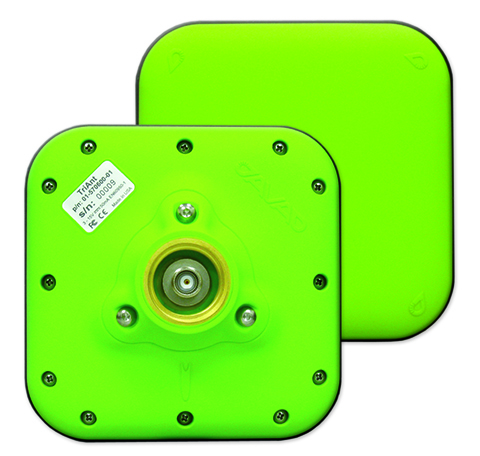
TriAnt is small, thin and rugged high-performance GNSS antenna. It measures 128 x 128 millimeters (mm) square and 39 mm thick. It can be mounted with three screws to flat surfaces. It is designed for applications such as machine control and surround anennas of the TRIUMPH-4X. The antenna cable is routed through the center of the antenna (TNC connector) for protection in harsh environments. The TriAnt can also be mounted on poles (1–14 inches thread) using its mount-pole attachment, which increases the thickness to 54.5 mm.
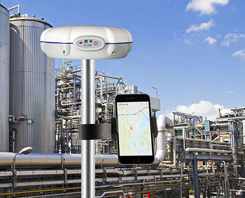
The X20i L1 GPS receiver by CHC Navigation is powered by a high-precision L1 GPS engine. Its integrated Bluetooth chip enables it to wirelessly collect submeter positions in real- time or centimeter post-processed on an iPhone or iPad. All location-aware apps on the iPhone and iPad are compatible with the X20i. Immediately after pairing and answering the security question allowing the X20i to take control of location services on the iOS device, 1 million iOS applications are capable of utilizing the high-accuracy data of the X20i, and become accurate to either 1 foot or 1 centimeter. Apps that can make use of the high accuracy include TerraGo Edge, ESRI’s ArcView Connector and those by CarteGraph Systems.
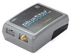
BlueStarGPS offers both GPS and GNSS options in a rugged, lightweight package. The BlueStarGPS device was designed to meet sub-meter mapping and data-collection needs in the pipeline and utility industries. It provides sub-meter precision without post-processing, and maintains accurate positioning when the SBAS signal is obstructed. This means it can function under trees, around buildings and in rugged terrain where other receivers can fail. The BlueStarGPS is designed specifically for use with Android mobile devices, such as smartphones, tablets or notebook computers, as well as cable and pipe “locating” tools with a connectivity range of up to 1 kilometer.
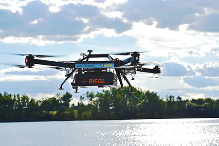
UAV measures through water surfaces of rivers, lakes
The RIEGL BathyCopter is a small-UAV-based surveying system capable of measuring through the water surface. It’s suitable for generating profiles of rivers or water reservoirs. The platform design integrates a topo-bathymetric green laser depth meter, an APX 15 inertial measurement unit (IMU)/GNSS with antenna, a control unit and a digital camera. Applications include generation of river profiles, survey of reservoirs and canals, landscaping, support of construction projects, and surveys for planning and carrying out hydraulic engineering work.
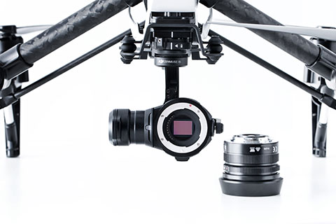
The Zenmuse X5 is a micro four-thirds (M4/3) camera designed specifically for aerial use. With a large sensor, aerial image makers will be able to capture up to 13 stops of dynamic range, enabling capture of high-resolution 16-megapixel photos or 4 k, 24 fps and 30 fps videos in complex lighting environments. It supports four interchangeable lenses. The Zenmuse X5 is designed for creation of high-quality aerial maps and 3D models, industrial and utility inspection, and professional video capture.
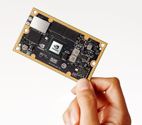
The NVIDIA Jetson TX1 module is designed to power smart devices — including drones that don’t just fly by remote control, but navigate their way through a forest for search and rescue. It is an embedded computer designed to learn to recognize objects or interpret information, incorporating capabilities such as machine learning, computer vision and navigation into a single system. This technology expands the ability of machines to operate on their own and adapt to their surroundings by recognizing images, processing conversational speech, or analyzing a room full of furniture and finding a path to navigate across it.
Aruba, a Hewlett Packard Enterprise company, has introduced a cloud-based beacon management solution designed for multivendor Wi-Fi networks and beacon analytics. Aruba also expanded its app developer partner program for the Meridian Mobile App Platform to accelerate innovation of location-based mobile apps.
Since its launch in November 2014, Aruba Mobile Engagement, powered by Aruba Beacons and the Meridian Mobile App platform, has improved customer satisfaction in such diverse organizations as Levi’s Stadium and Orlando International Airport, Aruba said in the news release. Aruba Mobile Engagement directly interacts with customers through their mobile devices based on the customers’ in-venue location and personalized preferences.
The new Aruba Sensor is designed to dramatically reduce IT overhead and make it easy to manage all beacons from a single location. Aruba estimates approximately 48 hours of time savings in a 1,000-beacon deployment during a single maintenance window.
The new enterprise-grade Internet of Things Aruba Sensor combines a small, Wi-Fi client and Bluetooth low energy radio to remotely manage beacons across existing multi-vendor Wi-Fi networks from a central location. For IT departments, this means easier and significantly more cost-efficient management and monitoring of beacon data including battery life, power settings and software updates, Aruba said.
Orlando International Airport (MCO), which hosts nearly 38 million travelers annually, implemented Aruba’s Mobile Engagement solution in late 2014 and has since seen more than 26,000 downloads of its MCO mobile app.
“Since so many travelers now rely on mobile apps, the accuracy and reliability of the information we’re delivering is paramount,” said John Newsome, director of information technology for the Greater Orlando Airport Authority. ” Today, to ensure this accuracy, our IT staff must monitor the beacons manually which is burdensome for such an extensive deployment. Using the new Aruba Sensors, however, we’ll be able to manage our beacons remotely, saving valuable time and IT resources.”
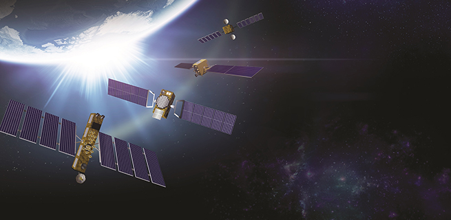
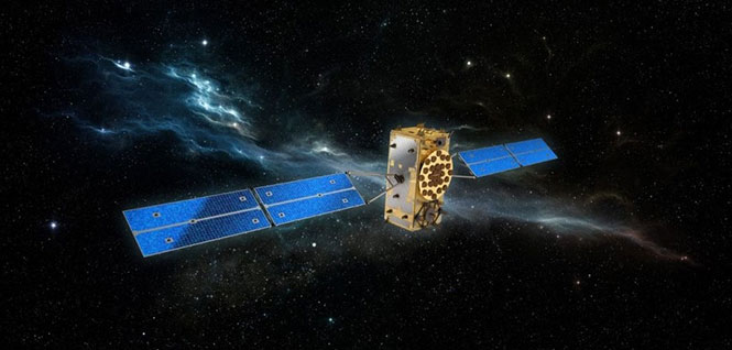
Having completed their rigorous checks in space, two more of Europe’s Galileo satellites are now fully operational, broadcasting navigation signals and relaying search and rescue messages from across the globe.
Galileo 7 and 8 were launched on March 27 from Europe’s Spaceport in French Guiana. Once the satellites were nursed to life in orbit, their navigation payloads underwent a lengthy test campaign.
This involved assessing that the satellites themselves were performing as planned and meshing with the worldwide Galileo ground network.
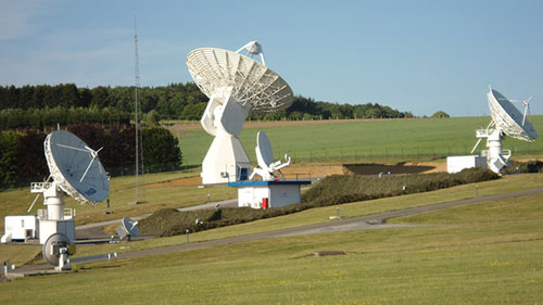
Galileo’s 20-m IOT L-band antenna is the largest dish at ESA’s Redu ground station.
The satellites’ secondary search and rescue payloads were also put to the test, picking up and relaying UHF signals from distress beacons as part of the international Cospas–Sarsat system.
Radio-frequency measurements were made from ESA’s Redu centre in Belgium. The site boasts a 20 m-diameter dish to analyse Galileo signals in great detail. Last but not least, security testing has ensured that Galileo’s Public Regulated Service – a maximum precision service restricted to authorised users – is as secure as required.
“These latest two operational Galileos are the third and the fourth Full Operational Capability satellites,” said David Sanchez-Cabezudo, ESA’s Galileo In-Orbit Test Manager.
“These are the versions that will make up the bulk of the Galileo constellation in space, with 16 satellites still to be launched.
“The checks carried out from the Galileo Control Centres in Oberpfaffenhofen in Germany and Fucino in Italy, as well as from Redu, prove the performance of these two satellites is excellent for navigation purposes.
“New onboard features such as seamlessly swapping between the different atomic clocks – a unique feature in global satnav systems – has been verified, which translates into more robust navigation services.”
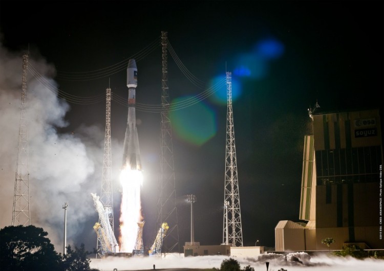
Liftoff of Soyuz ST-B flight VS11 carrying Galileo satellites 7 and 8, March 27 at 22:46 GMT, from Europe’s Spaceport in French Guiana.
The first pair of full satellites was placed in incorrect orbits in 2014 by a malfunction of their Soyuz launcher’s upper stage, but the elongated orbits have since been modified so that the navigation payloads can perform as planned. The European Commission is set to make a decision on whether they will be employed as part of the Galileo constellation.
The second pair, launched in March, was inserted into the correct orbits. September’s third pair, also in the correct orbits and undergoing payload testing, should enter service early next year.
The latest twins have arrived in French Guiana, aiming for a Soyuz launch on Dec. 17. The intention is to have those satellites ready to enter the operational constellation by next spring.
The founders of Chronos and UrsaNav have formed a new collaboration, named Taviga, that will focus on preserving and establishing low-frequency (LF) positioning, navigation and timing (PNT) networks the United Kingdom, Europe and the United States, using repurposed Loran-C or purpose-built eLoran technology.
Taviga — named for timing and navigation — aims to ensure timing and navigation for critical infrastructure from cyber and other threats, and address the concern that over-dependence on single systems for PNT increases vulnerability.
According to a joint press release, “Taviga combines the founders’ decades of experience specializing in low-frequency (LF) PNT technology and industrial timing applications at national and international levels. Its objective is to provide a commercially operated assured LF PNT service.”
Charles Curry, founder of Chronos Technology Ltd. in the UK, and Charles Schue, founder of UrsaNav Inc. in the United States, joined forces to launch Taviga Ltd. and Taviga LLC. Taviga anticipates working in partnership with government agencies and other entities that have a vested interest in reducing the vulnerability and improving the resilience of critical national infrastructure with a dependency on the GPS and other GNSS sources of PNT.
“We have been researching the precise timing capability of eLoran transmissions for over 10 years,” Curry said. “During that time, the system has never failed and most impressively it has continued to deliver sub-microsecond time accuracy traceable to UTC in some very challenging locations including deep inside buildings.
“Our research program was supported by the UK’s Innovation Agency – Innovate UK through two flagship projects, GAARDIAN and SENTINEL,” Curry continued. These two projects highlighted the vulnerabilities that threaten GPS signals (and in the future, Galileo) such as jamming, interference and spoofing. They also demonstrated how eLoran is a technically dissimilar source of PNT and not vulnerable to the same types of interference. eLoran is a truly complementary source of PNT ideal for use in critical infrastructure applications that demand precise time and timing such as telecoms, broadcasting, financial services and power utilities.
“Every government, academic and industrial study has resulted in the selection of the LF technology known as Enhanced Loran, or eLoran, as the best wide-area complement to GNSS,” Schue said. “There is no doubt that the combination of GNSS and eLoran provides the PNT resilience that most users require.
“Whether the application is timing/frequency, aviation, maritime, land-mobile, or location based, integrated GNSS-eLoran solutions can provide the proof-of-time and proof-of-position necessary to safeguard national infrastructure and for business continuity of operations,” Schue said. “Additionally, adding eLoran into the PNT mix enables or enhances the capabilities of regional and purpose-built solutions. PNT resilience results from an eco-system made up of layered solutions. Over reliance on a single solution is neither prudent nor safe. It’s time for Taviga.”
Tests have been conducted as part of Innovate UK supported research projects GAARDIAN and SENTINEL, which were led by Chronos Technology Ltd and included UrsaNav’s eLoran receiver engine. eLoran transmissions from the UK, Denmark, Germany, France and Norway have consistently demonstrated positioning accuracies of better than ten meters and timing accuracies of less than 100 nanoseconds in the area of differential eLoran reference sites. Taviga will now seek to engage those governments and others in discussions as to how to transition their Loran stations to commercial operation.
Taviga’s goal is the long-term operation of an eLoran system for at least 10 years. This length of time provides the necessary service assurance continuity to enable industrial users to invest with confidence in an eLoran-based timing and navigation service that complements their GNSS solutions. As users become accustomed to the additional capabilities and resilience provided with a combined GNSS-eLoran solution, Taviga expects to expand the service footprint into other countries worldwide.
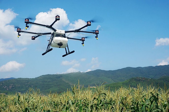
Unmanned aerial vehicle maker DJI has launched of a smart, crop-spraying agricultural drone. The DJI Agras MG-1 is dustproof, water-resistant and made of anti-corrosive materials. It can be rinsed clean and folded up for easy transport and storage after use.
The eight-rotor Agras can load more than 10 kilograms of liquid for crop-spraying and can cover between seven and 10 acres per hour. It is more than 40 times more-efficient than manual spraying, according to DJI. The drone can fly up to eight meters per second and adjusts spraying intensity to flying speed to ensure even coverage.
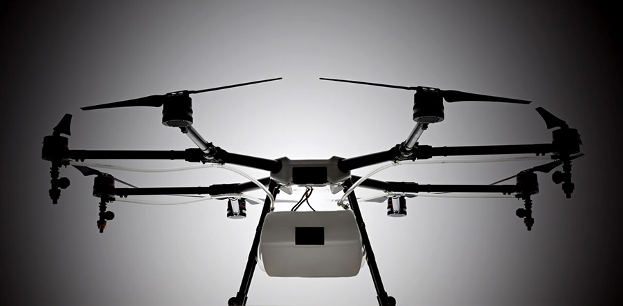
The Agras features DJI’s flight-control system and microwave radar to ensure centimeter-level accuracy. During flight, the drone scans the terrain below in real time, automatically maintaining its height and distance from plants to ensure application of an optimal amount of liquid. DJI’s real-time Lightbridge 2 transmission system is also onboard.
The DJI Agras MG-1.
Users can select automatic, semi-automatic or manual operation modes, depending on terrain, with uniform spraying carried out via the drone’s nozzles. The drone has four replaceable, ceramic nozzles, each powered by a motor. The included nozzles can be used for thousands of hours of spraying. Downward airflow generated by the rotors increases spraying velocity and ensures the agent will reach plant stems and leaves near the soil.
The Agras MG-1’s body is sealed, and features an integrated centrifugal cooling system designed to extend motor life by up to three times. Triple-filtration cuts off intake of mist, dust and large particulates to reduce wear from impurities. As the drone flies, air enters the aircraft body via the front inlet. It is then filtered and passes through each of the aircraft’s arms to the motors, capturing heat from all components and the entire structure. Heat is then dissipated by venting into the surrounding air.
The DJI Agras MG-1 is designed for crop spraying.
The drone’s intelligent memory function means after the Agras MG-1 is brought back to base for refill or recharge, it will return to its last memory point to pick up spraying where it left off.
Users control the Agras with a custom DJI remote. Its low-energy display panel gives real-time flight information and lasts for extended periods on a single charge.
The Agras MG-1 will initially be available in China and Korea and later in other markets.
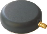
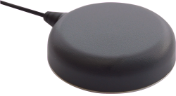
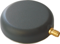
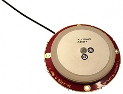
Tallysman has introduced the TW2920 antenna for simultaneous reception of L-band correction signals and all of the upper band GNSS signals, including GPS L1, GLONASS G1, Galileo E1 and BeiDou B1.
The TW2920’s 1-dB bandwidth covers 1525-1559 MHz for the L-band downlink and 1559-1610MHz for the upper-band GNSS.
The LNA of the TW2920 provides 28dB of gain; the TW2940 is a higher gain version with 35-dB LNA gain. The TW2926 antenna is an unhoused OEM version of the TW2920 with 28-dB of gain.
The antennas employ Tallysman’s Accutenna technology, which provides strong cross-polarization rejection for greatly improved multipath rejection, low axial ratio and tight Phase Center Variation (PCV).
All of the antennas include a sharp pre-filter to protect against sub-harmonic signals such 700MHz LTE and strong near frequency signals such as Wi-Fi.
The Tallysman TW2920.
The Tallysman TW2940.
The Tallysman TW2926.
The TW2920 and TW2940 have metal bases with wide temperature range plastic radomes, 57mm in diameter and 15mm in height, with a magnetic mount or adhesive mount along with four tapped screw holes. They are IP67 compliant and available with either a watertight SMA connector on the bulkhead or with a RG174 cable with your choice of connector.
The TW2926 OEM version of the antenna is 56 mm in diameter and has four drilled plated holes for secure mounting within customers’ products. This antenna can be custom tuned to ensure optimal performance within an enclosure.
PlanetiQ has signed a contract with Antrix Corporation Limited, the commercial arm of the Indian Space Research Organization (ISRO), for the launch of PlanetiQ’s first two weather satellites on a Polar Satellite Launch Vehicle (PSLV) during the fourth quarter of 2016.
Ten more satellites are planned for launch in 2017 to complete an initial set of 12 satellites that will dramatically improve global weather forecasting, climate monitoring and space weather prediction, and enable advanced analytics for numerous industries worldwide.
The ISRO’s PSLV is among the world’s most reliable launch vehicles with 30 consecutive successful flights. It has launched 51 satellites for international customers from 20 countries, in addition to 33 Indian national satellites.
“The stellar track record of the PSLV combined with our seven-year satellite design life provides the reliability and data continuity not just desired, but required by the operational weather forecast community,” said Chris McCormick, Chairman and CEO of PlanetiQ. “Within days after launch, we will validate and start delivering high-quality data and services to our customers.”
24 hours of data from 12 PlanetiQ satellites = ~34,000 occultations/day.
Each of PlanetiQ’s 10-kilogram microsatellites will fly PlanetiQ’s Pyxis-RO sensor, an advanced satellite weather sensor in a small package that can penetrate through clouds and storms down to the Earth’s surface. Pyxis-RO uses a technique called radio occultation to track the bending of GPS and other signals as they travel through Earth’s atmosphere, and then converts the bending angle into high-precision measurements of global temperature, pressure and water vapor in the atmosphere, and electron density in the ionosphere.
Pyxis-RO quadruples the data collection capability of radio occultation sensors on orbit today by tracking signals from all four major satellite navigation systems — GPS, Galileo, Beidou and GLONASS. With 12 satellites on orbit, PlanetiQ will collect 34,000 occultations per day, evenly distributed around the globe with high-density sampling over both land and water.
Each occultation is a vertical profile of atmospheric data with high vertical resolution, comprised of measurements less than every 200 meters from the Earth’s surface up into the ionosphere. The data is similar to that collected by weather balloons, but more accurate, more frequent and on a global scale.
“The world today lacks sufficient data to feed into weather models, especially the detailed vertical data that is critical to storm prediction. That’s why we see inaccurate or ambiguous forecasts for storms like Hurricane Joaquin, which can put numerous lives at risk and cost businesses millions of dollars due to inadequate preparation or risk management measures,” McCormick said. “Capturing the detailed vertical structure of the atmosphere from pole to pole, especially over the currently under-sampled oceans, is the missing link to improving forecasts of high-impact weather.”
SBG Systems has moved its United States headquarters office from Chicago, Illinois, to Huntington Beach, California.
SBG Systems is a supplier of miniature, high-performance and innovative motion sensing solutions. SBG Systems headquarters are based in Rueil-Malmaison, France.
Its California office has an additional 10,000 square feet. “We will be able to offer better delivery times, more convenient meeting facilities to meet our customers, and more space to allow our U.S team to keep growing,” the company stated in a press release. “The location allows more proximity with our customers in this highly economically dynamic area.”
New address and contact information:
SBG Systems North America, Inc.
5932 Bolsa Avenue, Suite #103
Huntington Beach, CA 92649
United States
 Agisoft is a world leader in the processing of digital imagery in order to generate high-accuracy 3D spatial data using photogrammetric and computer vision techniques, and has been developing imaging solutions for nearly 10 years. Topcon will provide the Agisoft Photogrammetric Kit for Topcon — Professional Edition software for post-processing of data collected using the Falcon 8 and Sirius Pro unmanned aerial systems (UAS).