Author: GPS World Staff

  • Using Reverse-Shift in J-Field

    By Matt Sibole

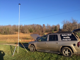
    One of the newest developments in J-Field, JAVAD GNSS’s onboard data collection software, is the Reverse-Shift. This feature will allow you to mount a base on a magnetic mount to the top of your vehicle, instead of putting your base on a tripod.

    This is a good idea for several reasons. First, you won’t have to worry about your tripod sinking in hot asphalt. Second, you will not have to worry about your tripod fading on frozen ground that begins to thaw.

    Figure 1. My TRIUMPH 2 base mounted above my driver-side door on the roof, with my 35-watt radio and antenna just to the left.
    Figure 1. My TRIUMPH 2 base mounted above my driver-side door on the roof, with my 35-watt radio and antenna just to the left.

    The way Reverse-Shift works is by starting your base on an autonomous position. Once your base has started transmitting, you can then go into your collect screen and change the point tab to shift. You then have the ability to select a known point (a previously surveyed or calculated point). After you have selected this known point, you can go and survey that known point.

    Figure 2. The shift screen showing the known point (previously surveyed point).
    Figure 2. The shift screen showing the known point (previously surveyed point).

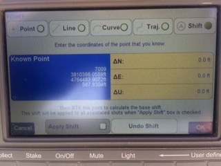
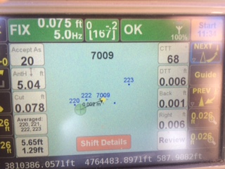
    When you hit OK as shown in Figure 2, this will take you back to the collect screen, and then it will allow you to survey that point. It will give you an warning screen that states, “You are in Base Shift Calculation Mode, Do you wish to continue?” You will then be able to collect a surveyed point on the previously surveyed or calculated point. It will then give you the position shift information.

    Figure 3. The adjustment parameters for the base.
    Figure 3. The adjustment parameters for the base.

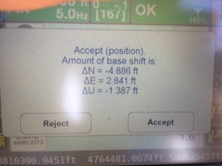
    Hit Accept, and this will adjust your base position by the stated difference, allowing you to continue to work on the known coordinate system without setting your base on a known point.

    Figure 4. Staking back out to the (known point) after the Reverse-Shift has been completed. Notice the DTT (Distance To Target) is 0.006. degrees.
    Figure 4. Staking back out to the (known point) after the Reverse-Shift has been completed. Notice the DTT (Distance To Target) is 0.006. degrees.

    At the end of the day, when you go back to your base, hit “Stop Base”. This will download the static data out of your base into your TRIUMPH-LS rover.

    The next morning when the CORS data has been uploaded, you can then post-process your base data using DPOS (JAVAD’s Data Processing Online Service). With DPOS you can then adjust your base to the TRUE state plane coordinate of where your base was actually sitting. It will also adjust all surveyed points that were collected from that base position.

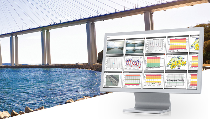
    For more information on JAVAD’s J-Field software, the TRIUMPH-LS or other JAVAD GNSS solutions, please feel free to visit www.javad.com, email [email protected], or call 1-888-550-5301 or 1-408-770-1770.

  • UTC to retain leap second at least until 2023

    The ITU World Radiocommunication Conference (WRC-15), in session in Geneva Nov. 2-27, has decided that further studies are required on the impact and application of a future reference time-scale, including the modification of Coordinated Universal Time (UTC) and suppressing the so-called “leap second.”

    Leap seconds are added periodically to adjust to irregularities in the earth’s rotation in relation to UTC, the current reference for measuring time, in order to remain close to mean solar time (UT1). A leap second was added most recently on June 30 at 23:59:60 UTC. The proposal to suppress the leap second would have made continuous reference time-scale available for all modern electronic navigation and computerized systems to operate while eliminating the need for specialized ad hoc time systems.

    The decision by WRC-15 calls for further studies regarding current and potential future reference time-scales, including their impact and applications. A report will be considered by the World Radiocommunication Conference in 2023. Until then, UTC shall continue to be applied as described in Recommendation ITU‑R TF.460‑6 and as maintained by the International Bureau of Weights and Measures (BIPM).

    WRC-15 also calls for reinforcing the links between ITU and the International Bureau of Weights and Measures (BIPM). ITU would continue to be responsible for the dissemination of time signals via radiocommunication and BIPM for establishing and maintaining the second of the International System of Units (SI) and its dissemination through the reference time scale.

    Studies will be coordinated by ITU along with international organizations such as the International Maritime Organization (IMO), the International Civil Aviation Organization (ICAO), the General Conference on Weights and Measures (CGPM), the International Committee for Weights and Measures (CIPM), the International Bureau of Weights and Measures (BIPM), the International Earth Rotation and Reference Systems Service (IERS), the International Union of Geodesy and Geophysics (IUGG), the International Union of Radio Science (URSI), the International Organization for Standardization (ISO), the World Meteorological Organization (WMO), and the International Astronomical Union (IAU).

    “Modern society is increasingly dependent on accurate timekeeping,” said ITU Secretary-General Houlin Zhao. “ITU is responsible for disseminating time signals by both wired communications and by different radiocommunication services, both space and terrestrial, which are critical for all areas of human activity.”

    “The worldwide coordination of time signals is critical for the functioning and reliability of systems that depend on time,” said François Rancy, Director of the ITU Radiocommunication Bureau. “ITU will continue to work with international organizations, industry and user groups towards providing coherent advice on current and potential future reference time-scales.”

  • FieldLogix releases ‘Goose’ fleet management app

    News ImageFieldLogix, a fleet management service company, has released its newest mobile application for iPhones, Goose.

    Goose allows dispatchers to optimize drivers’ routes and remain in direct communication. “It ensures that drivers have optimized routes, job details and navigation all on their iPhone,” the company said in a news release. “Goose simultaneously notifies the company’s clients of the driver’s ETA to ensure they are ready for the driver’s impending arrival via text messaging. Goose even accounts for Google’s real-time traffic speeds in its ETA calculations.”

    “Goose provides an Uber-like experience for the clients of delivery and service companies.” said Yukon Palmer, FieldLogix’s founder and CEO. “Rather than waiting around for a four-hour time window, a company’s clients now have more accurate ETA’s for driver arrival times. Plus, drivers will be much more efficient with their time on the road, allowing them to get home to their families in a timely manner. Dispatchers also benefit by properly planning their drivers’ workdays and staying on top of their statuses. Goose is a significant step into the future of GPS fleet management.”

    Goose provides ETA notifications via text message.

  • Leica adds to GeoMo geodetic monitoring solution

    Leica adds to GeoMo geodetic monitoring solution


    Photo: Leica Geosystems

    Leica Geosystems has introduced two new additions to its Leica GeoMo deformation monitoring solution: Leica GeoMoS AnyData and GeoMoS API.

    Users of the system can now create comprehensible visualizations and customizable reports, which enables powerful sensor data fusion for applications, such as air or water quality monitoring and construction or building management.

    With GeoMoS AnyData and GeoMoS API, multiple open interface standards are accessible to provide even more information to projects than just classic geodetic monitoring applications, according to a news release from Leica. The open solution offers flexibility; it is capable of automatically acquiring, processing and distributing intelligent information locally or via the Internet in real time.

    Leica GeoMoS integrates, processes and distributes all project data within one software program.

    “Monitoring professionals are confronted daily with vast amounts of data collected and provided by a variety of sensors,” said Michael Rutschmann, senior product manager of Structural Monitoring at Leica Geosystems, in the news release. “With these additions to Leica GeoMoS, all information is now easily accessible via web-based visualisation. This is absolutely the most efficient way to convert raw data streams into intelligent information for any user.”

  • Dredging replenishes Australia’s Sorrento Beach

    Dredging replenishes Australia’s Sorrento Beach

    Shifting sands in Australia’s Port Phillip Bay left a popular beach without enough sand this past holiday season. As summer approached, the Mornington Peninsula Shire and Australian Department of Environment and Primary Industries (DEPI) decided to replenish Sorrento beach by dredging a nearby sandbank.

    DEPI awarded the contract to Sandpiper Dredging because of its history of minimizing environmental impact. Sandpiper has a decade of dredging experience and builds its own precision dredgers in Tweed Heads, New South Wales.

    Sandpiper-2-Sorrento-W
    Erosion of Sorrento Beach required high-tech repairs. (Photo: Trimble)

    The contract specified the dredge ground extent and the minimum Australian Height Datum (AHD) height Sandpiper could dredge. To obtain precise 3D positions from the GPS receiver, GPS corrections were streamed in via cellular Internet from the Victorian government’s Continually Operating Reference System (CORS). Position and heading from the SPS461 receiver were interfaced into construction software to display dredge position. The inclinometer mounted on the dredge frame also interfaced with the software and allowed the AHD height of the cutter head to be displayed.

    The dredge position displayed in the software allowed operators to stay within the dredge grounds and ensure no over-dredging occurred. The software was the central hub in the wheelhouse displaying and logging dredge positions and the AHD height of the dredge head.

    Machine-control positioning enabled Sandpiper to precisely place in 3D the cutter suction head on the dredge frame in real time.
    Machine-control positioning enabled Sandpiper to precisely place in 3D the cutter suction head on the dredge frame in real time. (Photo: Trimble)

    The software also allowed the dredge operator to focus on controlling the dredge rather than trying to determine where to dredge. Using GPS and AUSGeoid09 removed the need for considering tide data because the software displayed the AHD height. The logged data could be delivered to the client as an as-built drawing.

    The beach was replenished within budget and on time for the holiday season, and the community is now enjoying the restored beach.

    Hydrographic Tech

    To achieve the job specifications and efficient operation of their dredge, Sandpiper needed hydrographic survey technology on board. SITECH Construction Systems, a Trimble distributor, provided the company with:

    • Trimble SPS461 GPS heading and positioning receiver
    • Inclinometer to measure the angle of the cutter head frame
    • Trimble HYDROpro dredge software to display and log seabed levels. The software can be configured for a wide range of dredgers.

    “After speaking about the challenges we had been facing, SITECH came back with the solution of the Trimble HYDROpro system, which meant we could dredge in exactly the right place and maintain coverage, all the while protecting the environment of the beach,” said Daniel Fristch, owner of Sandpiper.

    Sandpiper-3-Sorrento-W
    HYDROPro at work on the Sorrento Beach project. (Photo Trimble)
  • John Deere to acquire Monsanto subsidiary Precision Planting

    Deere & Company and The Climate Corporation, a subsidiary of Monsanto, have signed definitive agreements for Deere to acquire Monsanto’s Precision Planting LLC equipment business and to enable near real-time data connectivity between John Deere farm equipment and the Climate FieldView platform.

    This news comes after a Nov. 2 announcement that the company had acquired Monosem, a European precision planting company. John Deere said it will work with Monosem’s existing engineers to further develop its precision planting technology.

    The agreements represent the industry’s first and only near real-time in-cab wireless connection to John Deere equipment by a third party.

    “To maximize the value of digital agriculture, farmers need solutions for simple and seamless collection of in-field agronomic data,” said Mike Stern, president and chief operating officer for The Climate Corporation. “As a result of these milestone agreements, farmers will experience the fastest, most frequent and highest resolution third-party connectivity between John Deere’s equipment and the Climate FieldView platform.”

    “The agreements we are announcing allow John Deere to extend the range of retrofit options available from Precision Planting to many more products and into new geographies,” said John May, president, agricultural solutions and chief information officer at Deere. John Deere strengthens its position as the most open platform in the industry both in our equipment and the cloud-based data management solution known as the John Deere Operations Center.”

    Under the terms of the agreements, Deere will purchase Precision Planting while Climate will retain the digital agriculture portfolio that has been integrated into the Climate FieldView platform. The acquisition is subject to customary closing conditions, including the approval of the relevant antitrust authorities to the extent required.

    Stern said, “Our agreements enable farmers to combine the industry-leading technology of John Deere equipment with Climate FieldView, the platform that offers farmers the broadest equipment connectivity in the industry backed by data science. This connectivity allows farmers to collect and directly share data to the Climate cloud, enables data visualization in the cab and supports the development of customized data science-driven insights.”

    “This strategic acquisition expands the John Deere precision agriculture business and accelerates our momentum as a market leader,” May said. “Strategic use of information is an important factor in successful agriculture. Today’s actions demonstrate John Deere’s ongoing investments to enhance the product and service solutions we offer our customers.”

    The companies said customers will have the option to share their current and historical agronomic data between the John Deere Operations Center and the Climate FieldView platform and seamlessly execute agronomic prescriptions with John Deere equipment.

  • GPS World unveils new look for magazine, website

    GPS World's new logo
    GPS World‘s new logo

    CLEVELAND, Ohio — November 18, 2015 — GPS World relaunched this week with a redesigned print magazine and website, GPSWorld.com. Both feature a new logo, new design and widened coverage.

    The GPS World brand has expanded its technical coverage to include all GNSS and Position, Navigation & Timing (PNT) solutions, trends and applications.

    “We celebrated GPS World’s 25th anniversary in 2014 by embarking on the brand’s most-comprehensive research project to date,” said Kevin Stoltman, president and CEO of Cleveland-based North Coast Media, GPS World’s parent company.

    The GPS World team conducted a research project and used a rebranding/repositioning expert to help better serve its industry-leading family of readers and marketing partners for decades to come.

    “After months of comprehensive focus groups and surveys, we discovered readers and advertisers across the globe are fiercely loyal to GPS World,” Stoltman adds. “They love what we do, the information we offer. They just crave more of it: They want us to cover all GNSS and PNT technologies, trends and applications — and that’s exactly what we’re doing now, across all media platforms: print, digital and events.”

    GPS World November 2015
    GPS World November 2015

    The new GPS World publication also features a six-fold increase in segment-specific technical coverage — GNSS/PNT trends, obstacles and opportunities related to: Survey, Mapping, OEM, unmanned autonomous vehicles (UAVs), Defense, Mobile, Transportation and Machine Control. Those increase in segments also are reflected on GPSWorld.com.

    “GNSS — and GPS as its leading element — remains at the core of all that we and the industry do,” said Alan Cameron, editor-in-chief and publisher of GPS World. “But it has become abundantly clear that to deliver the everywhere-everytime solution, GPS/GNSS require augmentation, back-up and alternatives. This is the promise of the future for UAVs, critical infrastructure, defense, machine control, surveying, construction and countless other fields: a consistent, highly accurate PNT solution at all times. Our new brand and expanded coverage represent our commitment to the industry in pursuit of this goal.”

    The new website features a mobile-responsive design as well as new opportunities for website sponsorship with the Platinum Website Sponsorship option.

    About GPS World
    Founded in 1990, GPS World has an independently audited total unduplicated reach of 70,650 — delivering the largest audience in the industry. The B2B media brand publishes nine e-newsletters with a combined readership of more than 113,000, and conducts monthly technical webinars for engineers. Its website, GPSWorld.com, draws an industry-dominant 650,000 visitors and 1.5 million page views annually. (Source: June 2015 Verified Audit Circulation Annual Audit Report)

    For more information on advertising or sponsorship opportunities with GPS World, please contact International Account Manager Michelle Mitchell at [email protected] or 216-363-7922.


    GPS World is published by North Coast Media LLC, the largest B2B publishing company headquartered in Cleveland. NCM’s flagship brands include LP Gas, Pit & Quarry, GPS World, Pest Management Professional, Landscape Management and Golfdom. Ancillary brands include Portable Plants & Equipment, Geospatial Solutions, Athletic Turf, Truman’s Scientific Guide to Pest Management Operations and a host of other leading industry reference books.

  • Handheld launches its first ultra-rugged Android tablet

    Handheld launches its first ultra-rugged Android tablet

    Handheld Group's new Algiz RT7 tablet is designed for rugged use by mobile workers.
    Handheld Group’s new Algiz RT7 tablet is designed for rugged use by mobile workers.

    Handheld Group, a manufacturer of rugged mobile computers, today announced the launch of its new Android tablet, the Algiz RT7. The Algiz RT7 is a powerful, lightweight and ergonomic 7-inch tablet designed for reliable performance in demanding environments.

    The Algiz RT7, which runs Android 5.1.1 (Lollipop), provides a range of features for mobile workforces, Handheld said. It’s fully rugged, meeting stringent MIL-STD-810G U.S. military standards for protection against drops, vibrations and extreme temperatures, and its IP65 rating means that it’s waterproof as well as fully sealed against sand and dust. Weighing just 650 grams, the Algiz RT7 is designed for mobility.

    The Algiz RT7 comes with a built-in accelerometer, gyroscope and e-compass and a stand-alone u-blox EA-7M GPS receiver for navigation, along with built-in Qualcomm IZat location services.

    A Qualcomm MSM8916 (Snapdragon) chipset and 1.2 GHz quad-core processor power the tablet, giving it processing speed, ultra-fast connectivity and long battery life. It comes standard with LTE data and voice capabilities as well as 802.11 b/g/n WLAN, BT Class 1 and Class 2, and NFC functionality. It also has dual cameras (8-megapixel rear-facing and 2-megapixel front-facing), as well as dual SIM-card slots.

    Designed for the mobile worker, the Algiz RT7 sports a high-brightness 7-inch outdoor-viewable capacitive display that can handle true outdoor challenges. Battery performance is key for any mobile application, and the Algiz RT7 comes with a long-life 3.7V 6000mAh lithium-ion battery. Four programmable buttons allow users to launch and use applications in the field. To enhance data capture, users can choose an optional 2D imager or RFID plus 2D imager.

    “Our new Algiz RT7 offers enterprises an exceptional value and is a highly requested product from both our end users and our extensive partner network,” said Jerker Hellström, Handheld Group CEO. “This ultra-rugged tablet delivers best-in-class performance to assist fieldworkers in their daily tasks. The Algiz RT7 is built for tough environments and delivers a streamlined Android experience with power and features appropriate for market demands.”

    The Algiz RT7 can be ordered immediately. Shipping will start in December, with volume deliveries starting January 2016.

  • Project Overlord keeps your wheels safe with GPS

    Project Overlord keeps your wheels safe with GPS

    Photo: Project Overlord

    Project Overlord has launched RimTech in the U.S. Developed by former Nokia, IBM and Motorola executives, RimTech has a built-in GPS, motion sensor and camera, which attach to the tire and act as a security guard for automobile wheels. The vehicle owner controls the device through the accompanying iPhone and Android app, providing total control and surveillance at all times.

    Using a two-stage system to eliminate false alarms to police departments, the vehicle owner is immediately alerted of a security compromise. When the car’s tires are approached closer than 3 inches or moved over 3 mm, RimTech will sound a continuous alarm to deter the thief and alert the owner through a push notification on their phone. If the thief proceeds to remove the wheels from the vehicle, a second mobile alert will notify the owner of the movement while police are simultaneously informed of the property’s location and owner’s vehicle information. The owner can use their mobile RimTech app to track the wheel’s real-time location with an accuracy of less than 10 feet.

    “The auto industry has yet to introduce a fully comprehensive and effective wheel theft prevention system to the marketplace. Wheel locks are totally ineffective and can be removed in seconds. RimTech is the solution,” said Terrence Gaskin, founder and CEO of Project Overlord. “Project Overlord not only wants to protect your vehicle and its wheels, but also intends to partner with insurance companies to offer discounts for protected drivers.”

    According to a recent Yahoo! News article, “Tires and wheels offer a near-perfect combination of attributes to thieves. They’re easy to haul, quick to remove, untraceable on online auction or classified sites, and frequently usable on several different vehicles, with a value that can hit $3,000 and higher per set.”

    Product Highlights

    • App notifies users of tampered or stolen wheels
    • Alarm sounds if parked wheels are approached or move more than 3mm
    • App tracks stolen wheels and notifies authorities
    • Battery lasts a minimum of two days in tracking mode
    • Device captures at least 25 photos of surroundings and thief
  • Bullray UAS designed for defense

    Bullray UAS designed for defense

    Photo: Bullray UAS

    The Bullray UAS is a fully autonomous, amphibious, man-portable tricopter/quadcopter that makes vertical take-offs and landings.

    Rated IP-67, the rugged design is capable of performing in all weather conditions and doesn’t require a transit case. It can carry a significant sensor payload: GPS, FLIR cameras, lidar, metal detection systems and more.

    Rapid Composites ­­— builder of high-end UAVs for the military and first responders — custom manufactures the units. The company won the UAV category in the 2015 JEC Innovation Awards.

  • Canal+ broadcasts race with GPS GeoRacing system

    Canal+ broadcasts race with GPS GeoRacing system

    Photo: Canal+

    Canal+, a French cable television channel, used Trimaran’s GeoRacing GPS tracking and visualization system to improve live television coverage of the Tour de Corse 2015, the FIA World Rally Championship held on the island of Corsica in October.

    Through a combination of GPS data and advanced technologies like virtual timing and ghost visualization, Trimaran’s GeoRacing solution allowed Canal+ to track the motorsport race in real time and better visualize its progression, enhancing the television viewer’s experience. The system dramatically improves the broadcaster’s ability to deliver live audio commentary about the race, giving viewers a race-time comparison of the drivers along with other important stats.

    During the Tour de Corse race, Canal+ used multiple cameras with GPS trackers in cars and helicopters, and at the starting, mid-point and finish lines. The GPS tracking system situated on the cameras was provided by AMPVisual TV, a technology partner of Canal+ and Trimaran.

    Throughout the race, GPS positioning from each of the cars was sent to the GeoRacing system. Using Trimaran’s solution, Canal+ instantly delivered detailed sports information and statistics, such as speed, timing (retiming for staggered starts) and ranking. This enabled viewers to better understand the progression of the live race.

    With the virtual timing capability, Canal+ was able to demonstrate the virtual differences between cars at a precision of 1/10th of a second. Trimaran’s ghost visualization feature provides a 3D representation of the rival positions in real time, creating the feeling that the cars all left the starting line simultaneously.

  • Routescene maiden flight pushes boundaries

    Routescene maiden flight pushes boundaries

    Routescene has jointly developed with Hanseatic Aviation Solutions an integrated fixed-wing UAV and LidarPod solution for surveying.

    Following in-depth customer research, Routescene identified a gap in the market for an unmanned aerial 3D mapping solution capable of flying long distances, particularly for use in large countries with great expanses of remote land such as Australia, the United States, Canada and Eastern Europe. The integrated solution would be used for long-distance surveys, such as powerline inspections in the utilities sector, biomass mapping of forests and geophysical surveys.

    The successful maiden flight of the integrated Hanseatic S360 and Routescene LidarPod took place in July in Bremen, Germany, and demonstrated its capability by collecting sample data. German aviation authorities were so confident in the product, they gave Routescene permission to fly in the same circuit as manned aircraft.

    A 3D point cloud of  the runway at Bremerhaven Airport.
    A 3D point cloud of
    the runway at Bremerhaven Airport.

    Benefits

    The LidarPod is integrated internally within the S360 itself, rather than being wing-mounted, reducing drag and enabling longer flight and survey times. Integration of the LidarPod into the nose cone minimizes noise and vibration traveling from the rear-mounted engine, ensuring the GNSS/INS is not adversely affected. It also enables more accurate positioning.

    The S360 is fixed-wing and built for long-distance flights, with four-hour endurance in the standard configuration, along with long-range telemetry, an autopilot system and a mission planning tool. It works in up to Force 7 winds, extending the operational window in which surveys can be performed. Its significant payload capacity enables the integration of additional survey and geophysical sensors as well as the LidarPod. Because this is an internally integrated solution, it can be set up rapidly and is easy to deploy in the field, Routescene said.

    Michael Schmidt, managing director of Hanseatic Aviation Solutions, and Gert Riemersma, CEO of Routescene, met for the first time at INTERGEO 2014. They immediately understood the potential power of a collaboration.

    Routescene launched the LidarPod at that trade show. It quickly attracted wide interest and is now generating business across four continents, Routescene said.

    After exploratory discussions with clients, the companies started development of the system in earnest at the start of 2015. “We have already seen significant interest from the forestry and geophysical exploration community,” Riemersma said.