The Federal Aviation Administration (FAA) wants unmanned aircraft owners to know that there’s no need to work with a “drone registration” company to help them file an application for a registration number.
Owners should wait until additional details about the forthcoming drone registration system are announced later this month before paying anyone to do the work for them.
The Task Force assigned to provide FAA Administrator Michael Huerta with recommendations on the registration process is still days away from delivering this information. But at least one company is already offering to help people register their drones — for a fee.
Speaking to the Task Force two weeks ago, Administrator Huerta told the group to provide guidance on a streamlined unmanned aircraft registration process that will be simple and easy to complete, and which types of UAS would need to be registered and which would not. The Task Force agreed and is working on recommendations for a system that is similar to registering any newly purchased product with its manufacturer, as well as a minimum weight for unmanned aircraft that must be registered.
Drone owners should visit FAA.gov for official updates on the unmanned aircraft registry.
Carlson Mining 2016 has improvements and added support for AutoCAD 2016 and the new IntelliCAD 8.1. The improvements span the four mining modules: Basic Mining, Geology, Surface Mining, and Underground Mining.
An upgrade to the Haul Truck Cycle Analysis command now accounts for mixed fleets, delay points and 3D playback of trucks along the haul route.
In the Underground Mining module, support has been added for multi-level mining with the addition of level labels, allowing the processing of overlapping mine panels with ease.
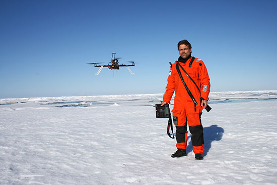
Researchers conducted an autonomous multicopter flight in the Arctic with its own test UAV platform that used a u-blox LEA-M8T GPS receiver. (Photo: Alfred-Wegener Institute)
How do you successfully pilot a UAV in the remote expanses of the Arctic Ocean when the compass can’t provide reliable positioning data? Engineers on board the Alfred Wegener Institute’s (AWI’s) research icebreaker Polarstern specially programmed a multicopter, allowing it to navigate despite the deviations produced by the Earth’s magnetic field near the North Pole. The researchers recently celebrated the copter’s first successful autonomous flight and landing on an ice floe.
“At high latitudes, autonomous navigation is a major challenge,” said Sascha Lehmenhecker, an engineer at AWI. “Navigation systems normally use magnetic sensors. But near the poles, the lines of the Earth’s magnetic field are nearly perpendicular to the ground, making precise navigation extremely difficult. That’s why commercial multicopter control systems aren’t well suited for use in polar regions.”
Ice Floe Landings
Lehmenhecker’s team refined the control systems for multicopters to land on ice floes and fly back to their “mother ship” autonomously several hours later. The particular task: both the ice floe and the ship are in motion. The ship has to continue on its scheduled course to conduct other research, while wind, waves and currents cause the ice floe to drift. It’s precisely the direction and speed with which it drifts that the multicopter needs to determine.
The team pursued two approaches. “In the first approach, the multicopter remains in constant contact with a receiving station, which uses the copter’s GPS data to calculate the discrepancies. In other words, the multicopter transmits its GPS position to the station, which in turn transmits back the corresponding, adjusted coordinates,” explained Lehmenhecker. “The second option: We use two onboard GPS receivers to calculate the actual change in the copter’s position. Though this is the better method, it’s also much more complex, and we’re still just starting to develop it.”
The system passed its first test, conducted on an ice floe in the arctic Fram Strait (79° N parallel). In the test, the team and copter were left on a floe, clear of magnetic interference produced by electric motors on board the Polarstern. The team manually flew the copter 3 kilometers out, to the edge of visual range, then activated the autonomous return program. The multicopter flew to the preset coordinates and safely landed on its own.
Underwater Assist
Lehmenhecker’s team came up with the idea for this development in connection with the use of sensitive devices under the ice, such as the torpedo-shaped autonomous underwater vehicle (AUV) Paul, which explores the ocean beneath the sea ice. “To optimally plan its dives, it’s important to have precise information on the movement of the sea ice,” Lehmenhecker said. Conventionally, this was achieved by deploying ice trackers on floes with the help of a Zodiac boat or helicopter — a difficult and time-consuming method. Further, the researchers generally try to avoid leaving the safety of the Polarstern wherever possible — jagged ice floes and polar bears present additional risks.
During 2012, the group first used a UAV to assist Paul. The UAV landed on the ice via remote control, then used GPS to determine its position and transmit the data back to the research ship, which was monitoring Paul’s dive. In this way, the multicopter took on an important role, offering navigational support for the AUV. Once each dive was complete, the ship had to return close to the multicopter’s position so the pilot could remotely guide it back to the ship, which was only possible in visual range.
Now, the new developments “will expand the service radius of our copters from visual range to as much as 10 kilometers,” Lehmenhecker said.
The United Launch Alliance (ULA) declined Nov. 16 to submit a bid to launch the GPS III satellite, leaving the field wide open for commercial launch service SpaceX, reports Space News.
The first GPS III satellite is expected to launch in 2018.
Every operational GPS mission has launched on a ULA or heritage rocket — the most recent being the GPS IIF-11, which launched on Oct. 31.
ULA said it did not submit a bid in part because it does not expect to have an Atlas 5 rocket available for the mission, according to Space News. Legislation passed by Congress in 2014 requires the Air force to phase out its use of the Russian-made RD-180 engine that powers the Atlas 5 rocket used by ULA.
Storm Surge in downtown New York City in the aftermath of Hurricane Sandy. (Photo: USACE)
By JoAnne Castagna
U.S. Army Corps of Engineers
Hurricane Sandy led to one of the largest-scale U.S. evacuations in recent history, according to Edward Schneyer, director of Emergency Preparedness, Suffolk County (N.Y.) Office of Emergency Management.
“During Sandy, we rescued 250 people from their flooded homes, evacuated two major hospitals and several adult care homes,” Schneyer said.
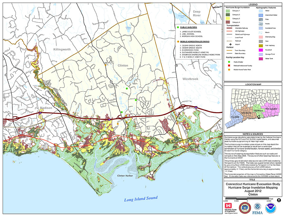
Schneyer was able to do this effectively because his agency uses storm surge maps created by the U.S. Army Corps of Engineers, New York District. Storm surge is when a significant amount of water is pushed from the sea onto the land caused by a hurricane.
The maps provide emergency managers in hurricane-prone states with an understanding of storm surge potential that could occur for worst-case Category 1 to 4 storms, identifying areas from which people should evacuate if faced with the threat of storm surge.
The Army Corps is updating these maps with higher resolution modeling and topography performed by NOAA’s National Hurricane Center’s Storm Surge Unit, so agencies will have more accurate information to educate the public — reducing risk to themselves and their property.
Hazard Analysis
“Historically, 49 percent of human causalities from hurricanes are due to storm surge,” said Donald E. Cresitello, the Corps’ Hurricane Evacuation Study program manager for the New York District. “Other impacts like riverine flooding due to rainfall, falling trees due to high winds, and indirect impacts like carbon monoxide poisoning and electrocution can cause deaths. The development of these maps is the first step in the hazard analysis for the hurricane evacuation study process.”
The “New York Hurricane Evacuation Study Hurricane Surge Inundation Maps” are being produced in collaboration with the Army Corps’ New England and Baltimore Districts and provided to emergency managers. The Army Corps also guides emergency managers on using the maps in the decision-making software HURREVAC (Hurricane Evacuation), developed by Sea Island Software for the National Hurricane Program.
“Agency officials can use these maps to help reduce risk to the public,” Cresitello said. “They can use them for evacuation planning, to redefine their hurricane evacuation zones, identify where shelters should be located and identify where assets should be staged prior to impact from a storm.”
The new maps will not only show the extent of inland storm surge, but also the depth of the water — in ranges of feet — during different categories of storms, enabling emergency managers to better focus limited resources.
“In the initial stages of a response, our recovery resources are limited, especially for an event the size of Sandy. If resources are dispatched to areas that were not impacted, valuable time is lost mobilizing and reassigning those resources,” Schneyer said.
At press time, Schneyer’s agency is entering information from the maps into an interactive program viewable on its county’s website, so the public can see whether their home is in a storm surge zone and which designated shelter is nearby. During Sandy, people who should have evacuated were stranded and faced dangers such as electrocution from downed power lines and fires from gas leaks.
“This very valuable resource is an excellent tool for public education, emergency management planning, and emergency preparedness in general,” Schneyer said.
Connecticut shoreline: This example of a storm surge map shows the extent of surge that can be expected as a result of a worst-case scenrio that combines hurricane landfall location, forward speed and direction for each hurricane category. (Credit: USACE)
Using GIS to Create Higher Resolution Maps
Geographic information systems (GIS), which capture, store, analyze and display location information, are being used to create higher resolution storm surge maps.
To create the maps, the Corps of Engineers uses the SLOSH model (Sea, Lake, Overland Surges from Hurricanes) provided by the National Oceanic and Atmospheric Administration (NOAA). The SLOSH data is layered over lidar-based topography in Esri ArcGIS software.
“To come up with the actual depth of water through GIS, we are overlaying the data out of NOAA’s SLOSH model and subtracting out the ground elevations using digital elevation models and coming up with an actual depth of water in feet,” said Donald E. Cresitello, USACE Hurricane Evacuation Study program manager for the State of New York, U.S. Army Corps of Engineers, New York District.
JoAnne Castagna is a public affairs specialist and writer for the U.S. Army Corps of Engineers, New York District.
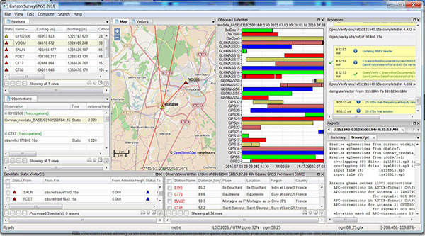
Carlson SurveyGNSS, Carlson Software’s data post-processing software, is now available in a 2016 version.
Designed for surveyors and positioning professionals, Carlson SurveyGNSS post-processing software achieves high-accuracy results for computing quality vectors and resultant positions. SurveyGNSS works with Carlson SurvCE and SurvPC data collection software, and with Carlson’s office design software.
New features include a second-generation post-processing engine, which now accepts data in enhanced RINEX 3.x formats. Users will also determine candidate vectors for simultaneous calculation. Previously, vectors were calculated individually.
Other processes have been sped up or enhanced. With “detached processing,” users will be able to start another task while SurveyGNSS is still working on a computation.
New constellation and more reference networks are another enhancement. Observations from the Chinese BeiDou and European Union Galileo join GPS and GLONASS, with future constellations in the works.
For supported “Active” (Online) Reference Networks, the International GNSS Service (IGS) and the governments of Australia, Brazil, Canada, Germany, Spain, European Union, France, Great Britain, Mexico and the Netherlands join the supported networks in addition to the U.S. CORS system.
TomTom has signed a global, multi-year agreement to provide maps and traffic data for the Uber driver app.
TomTom’s advanced map-making technology, combined with its traffic information, will ensure Uber has a seamless navigation experience, accurate arrival times and efficient journeys in more than 300 cities around the world, according to a TomTom news release.
“We are excited to provide Uber with our best-in-class location data,” said Charles Cautley, managing director, Maps and Licensing at TomTom. “TomTom is a truly independent map provider with the platform for the future. With this platform, TomTom is the trusted partner for innovative and future proof location technology for the global automotive and consumer technology industry.”
“We look forward to working with TomTom, a leader in the mapping and navigation space,” said Matt Wyndowe, head of Product Partnerships at Uber. “Their mapping and traffic data will help ensure we continue to provide a great experience for drivers everywhere.”
In the novel The Martian, an astronaut must navigate around a duststorm using his wits.
By Tracy Cozzens Managing Editor
Last year on my way home from ION GNSS+, I spotted a bright orange book in the San Francisco airport. The Martian, by Andy Weir, is now a major motion picture — a wonderful movie, but one that left out a unique PNT adventure.
The Martian explores how a lone astronaut struggles to survive long enough to be rescued from the Red Planet. Weir sets his story in the near future, and grounds it in real-world science. How can a man survive in a hostile environment far longer than the supplies left for him will hold out? What life-support systems can he engineer with the resources on hand?
From page one, I plunged into a gripping adventure — sometimes on the edge of my seat, sometimes thinking about engineering and science in new ways. I found myself re-reading explanations for astronaut Mark Watney’s resourceful solutions (shades of MacGyver) to make sure I understood what he was attempting and how it might actually work. But Weir also infuses the story with humor, so it’s never dry. It moves quickly, jumping between Watney’s situation on Mars and mission control on Earth.
One sequence in the book describes Watney’s ingenuity in solving a navigation problem in a truly GPS-denied environment, with only the limited supplies he has on hand. I don’t want to spoil anything, but I will say that the solution includes old-school triangulation, with a few twists. With a fierce dust storm bearing down on him, Watney employs his knowledge of position, navigation and timing to aid in his own rescue. I was reminded of this as we at GPS World embark on our own adventure, reimagining our scope to include PNT and other location technologies. GPS, while still in our name, is far from the only solution.
While the movie is excellent, I suggest anyone who’s fascinated by the science in fiction pick up a copy of the novel that inspired it.
In the temperate rainforest of the Los Lagos region of Southern Chile, where rainfall annually exceeds 1,500 millimeters and two-thirds of the days are rainy, the dense forest canopy poses a huge challenge for GNSS receivers.
Motivazion, a survey firm based in Puerto Montt, just below the rainforests, makes its living surveying in the rugged terrain under the densely canopied forest. Motivazion works primarily for hydropower development companies, surveying contours, cross sections and longitudinal profiles, as well as staking out proposed facilities. To ensure it was using the best GNSS receivers for the conditions, Motivazion conducted field tests of several sets of equipment this summer.
Motivazion owner Jorge Mesias said he typically uses a combination of total stations and GNSS receivers for his work. “If understory performance could be improved, efficiency would increase dramatically and reduce the need for using the more time-consuming total station,” Mesias said.
A light rain fell at all times during the two-day test. The test routine consisted of surveying a total of 21 points in two days. Results were compared to points established by a total station.
Base stations were set up in a small area cleared for the purpose, and the rovers moved from point to point under the canopy. Spectra Precision’s SP80 achieved fixed solutions in less than three minutes 95 percent of the time.
“The SP80 achieved remarkable results,” concluded Mesias. Geocom S.A., Spectra Precision’s dealer in Chile, provided the SP80 and technical support.
Avago Technologies Ltd. will move ahead with its merger with Broadcom Corporation, following a shareholder meeting Nov. 10 where shareholders overwhelmingly approved the business transaction.
Avago and Broadcom announced their merger agreement on May 28. The companies have received clearance on the proposed merger from the Committee on Foreign Investments in the United States and antitrust authorities in the United States, Japan and Taiwan.
Among other customary conditions to closing, the transaction remains subject to regulatory approvals from the European Commission and antitrust authorities in China and South Korea, all of which are progressing. Avago anticipates that these remaining approvals will be received and expects the transaction to close late in calendar year 2015 or early in 2016.
Avago Technologies is a designer, developer and global supplier of a broad range of analog semiconductor devices with a focus on III-V based products and complex digital and mixed signal CMOS based devices. Its product portfolio includes thousands of products in four primary target markets: wireless communications, enterprise storage, wired infrastructure and industrial, and other.
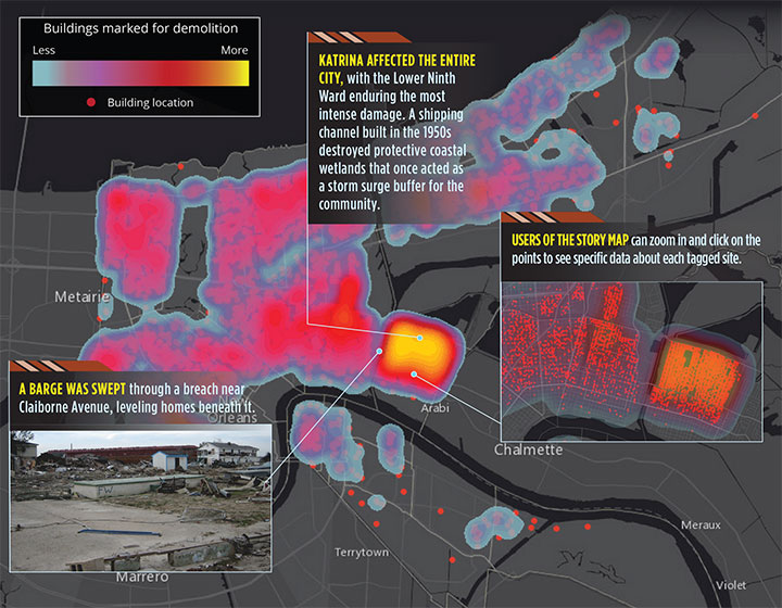
In August 2005, Hurricane Katrina struck the city of New Orleans, causing devastating damage and loss of life. A new Esri story map, “Katrina +10: A Decade of Change in New Orleans,” analyzes the damage from the storm.
“The story map is a new Esri medium for sharing not only data, photos, videos, sounds and maps, but for telling a specific and compelling story by way of that content,” wrote Esri Chief Scientist Dawn Wright in a blog. “This is all done with sophisticated cartographic functionality that does not require advanced training in cartography or GIS.” According to Wright, story maps are applications built from web maps, which in turn are built from web-accessible data.
The below map shows the physical damage in terms of buildings marked for demolition. In all, 10,317 buildings were tagged for demolition by the city of New Orleans. Following Hurricane Katrina, all properties within the city were reviewed for damage under Section 106 of the National Historic Preservation Act.
The heat map shows the density of houses deemed eligible for federally funded demolition through the Federal Emergency Management Agency (FEMA). Although not all properties on this map were demolished, the points illustrate Katrina’s extensive and pervasive physical toll on the city of New Orleans.
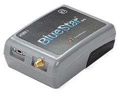
BlueStarGPS offers both GPS and GNSS options in a rugged, lightweight package. The BlueStarGPS device was designed to meet sub-meter mapping and data collection needs in the pipeline and utility industries. It provides sub-meter precision without post-processing, and maintains accurate positioning when the SBAS signal is obstructed. This means it can function under trees, around buildings and in rugged terrain where other receivers can fail.
The BlueStarGPS is designed specifically for use with Android mobile devices, such as smartphones, tablets or notebook computers, as well as cable and pipe “locating” tools with a connectivity range of up to 1 kilometer.