Author: GPS World Staff

  • GPS-powered advertising geo-targets moving vehicles

    GPS-powered advertising geo-targets moving vehicles

    MediaSignage-GPS-LBS
    With the service, media players display a content loop with information specific to the vicinity of the vehicle.

    MediaSignage has released GPS-powered, location-based services (LBS) for digital signage. The tool provides specific geo-targeting of advertising campaigns based on the location of the screen.

    The GPS-enabled location targeting works well for buses, taxis and trains, because advertisers can more easily target their digital signage content based on a targeted geographic radius, MediaSignage said in a press release.

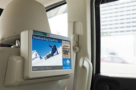
    For instance, a taxicab may provide digital signage behind the headrest and allow local advertisers to target messages to patrons that ride within the cab. When a moving car, bus or train enters the desired radius (such as close to a specific restaurant or local venue), the installed media player displays a new content loop with information specific to the vicinity. Once the media player moves out of that vicinity, the original content loop resumes.

    MediaSignage has designed the tool to be simple and affordable, enabling any business owner to have their message presented in a matter of a few minutes. Users can log in to StudioLite, set the radius on a map, and set the priority duration for each content resource that is to be displayed. Users can set radius location information for several desired areas within a geographic footprint.

    When users combine the power of GPS tracking into moving digital signage, the ability to target for advertising purposes becomes extremely powerful, MediaSignage said. Placing local advertisements in taxi, bus, train and even Uber cars provides a powerful tool for selling ads and targeting customers.

    “We are extremely pleased and excited by this latest feature implementation within our system,” said MediaSignage president Nate Nead. “It provides an additional value-adding tool for digital signage business owners and operators, allowing them to better monetize their display screens in a host of different and non-traditional environments. We hope our users will take full advantage of the new features and that the features will provide a profit-enhancing tool for their businesses.”

  • Filtronic Offers Cellular + GPS Splitter/Combiner

    Filtronic Offers Cellular + GPS Splitter/Combiner

    The PXC021-V2 by Filtronic.
    The PXC021-V2 by Filtronic.

    The new PXC021-V2 by Filtronic is a wideband cellular + GPS low-loss splitter/combiner.

    Designed for repeater/DAS applications, the PXC021-V2 provides GPS L1 and L2 frequency coverage and wideband cellular frequency coverage (618-960 MHz and 1695-2690 MHz). It has low loss (≤ 0.30 dB Cellular and ≤ 0.70 dB GPS) and excellent cellular to GPS isolation (≥ 55 dB).

    The L1/L2 Channel Absolute Group Delay is 20 nS maximum (17 nS typical), and the variation is 4 nS p-p maximum over the L1/L2 bandwidth. The

    The PXC021-V2 is IP67-rated for outdoor use.

  • Topcon offers control box for excavator systems

    Topcon offers control box for excavator systems

    Topcon's GX-55
    Topcon’s GX-55 control box for machine-controlled excavation.

    Topcon Positioning’s  GX-55 control box for machine-controlled excavation is now available in the Americas. With the release of the GX-55, Topcon adds three new 2D and 3D systems to its line of excavation solutions — the X-52 as well as the X-53 and X-53i. In any solution, the GX-55 is designed to provide users with new visual and audible features to achieve grade safely and efficiently for 2D or 3D excavating tasks.

    “The bright and robust GX-55 delivers the highest quality graphical experience for modern machine control,” said Kris Maas, director of construction product management. “Today operators use Sitelink3D to instantly communicate entire job activities to managers on-the-go.  The GX-55 delivers this real-time project information faster than ever.”

    “Whether you want to take advantage of Topcon 2D, 3D or 3D indicate machine controlled excavation systems, the new GX-55 is delivered in a lightweight package for easy machine transfer, storage, and quick cable attachment,” Maas said.

    The large 6.5-inch sunlight-viewable and color LCD touchscreen is surrounded by integrated LED light bars for a continuous grade reference of the bucket’s teeth. Additional features include customizable audible tones for grade reference, integrated virus protection, and easy-access USB ports for saving and downloading job files, Topcon said.

  • Driverless conference focuses on strategies for autonomous car

    With automakers and Silicon Valley technology companies rolling out their strategies for the autonomous car, keeping on top of the latest technology, worldwide markets and regulation will be critical. Enter Driverless, a conference that will be held March 22-23, 2016, at the Crowne Plaza Hotel, San Francisco Airport.

    Attendees at the conference can find out what technology and markets will prevail from both Detroit and Silicon Valley perspectives from some of the most important executives in the business, explains event organizer and GPS World LBS Editor Kevin Dennehy.

    Driverless will feature more than 30 executive speakers covering the most important issues facing the autonomous vehicle industry. Driverless is an exclusive one-day conference that features an early bird reception on the evening before, a hosted luncheon, and an industry-best two-and-a-half hour reception with more than 15 exhibits from prominent companies.

    Those attending can learn the answers to these questions:

    • What technological, social and legal issues face ADAS and autonomous vehicle progression?
    • What technologies are solving the high cost of rolling out autonomous systems?
    • How can companies adequately test vehicles?
    • How will car sharing revolutionize the autonomous vehicle industry?
    • Who are the most innovative players and what are their intentions?
    • What are consumer expectations?
    • What systems are evolving… and for what markets?
    • Who owns this market? The technology companies or traditional automakers?

    Learn more at the conference website.

  • IZT Solutions’ over-the-air system tests GNSS receiver performance

    German research organization Fraunhofer Gesellschaft has developed and presented an over-the-air (OTA) wave-field synthesis system for test and certification of GNSS receivers. The testing platform is at its Fraunhofer IIS Facility for Over the Air Research and Testing (FORTE) in Ilmenau, Germany.

    The innovative and complex OTA test system is based on hardware and software solutions from IZT GmbH, such as powerful RF receivers and high-performance signal generators.

    The demonstrated setup to test GNSS receivers represents a new approach that — in contrast to conventional conducted and open-field tests — realistically emulates real-world scenarios under controllable and repeatable conditions, enabling the realistic comparison of receivers and algorithms. The OTA test system is cost-effective, flexible and scalable.

    The newest generations of mobile communication systems employ multiple antennas for transmission and reception, such as LTE, LTE-A, WIMAX and Wireless LAN. Multiple Input Multiple Output (MIMO) OTA test systems are typically deployed for certification, performance testing and product evaluation of broadband wireless devices. The related devices have to be tested in their related environments.

    In contrast to mobile phones, GNSS receivers are extremely susceptible to all types of interference. Hence, the goal was to develop a new testing method for interference robustness of GNSS receivers.

    The OTA Test Approach

    The OTA test laboratory comprises a satellite signal emulator (Spirent) used as signal source, several OTA channel emulators used for wave-field synthesis that are able to emulate any electromagnetic environment in an anechoic chamber, and several OTA illumination antennas. The OTA channel emulators from IZT GmbH support 8 input and 32 phase coherent output channels (up to 256 logical channels) in the frequency range of 1 to 6 GHz, and provide the output signals to the OTA illumination antennas. Note that the final extension of the system based on the IZT components will have 12 x 32 channels.

    The unique test environment developed at FORTE together with IZT GmbH excels in its great flexibility regarding possible applications in communications technology. The new OTA emulation approach enables realistic radio channel emulation taking into consideration multipath propagation, multi-frequency, and multi-user scenarios.

    The OTA system supports emulation of complex channel impulse responses of nearly unlimited length. Besides GNSS equipment, the test system can be applied for LTE and Cognitive Radio (CR), sensor networks (including energy networks and smart metering) or car-to-car and car-to-infrastructure communications.

    The Innovationszentrum für Telekommunikationstechnik GmbH IZT is a spin-off of the Fraunhofer-Gesellschaft, Germany’s leading institution for applied research. Founded in 1997 in Erlangen, the company emanated from the Fraunhofer Institute for Integrated Circuits (IIS). It specializes in advanced digital signal processing and field programmable gate array (FPGA) designs in combination with high-frequency and microwave technology.

  • GLONASS-M Satellite Scheduled for Launch on Dec. 29

    The next GLONASS-M satellite will be launched on Dec. 29, according to Russian news agency TASS.

    GLONASS-M 51 will replace a satellite put into orbit in 2005, which has exceeded its design life by three years. The lifetime of a GLONASS-M is approximately seven years. 

    In addition, not earlier than February, a trio of GLONASS-M satellites is expected to be launched.

    GLONASS-M 51 is now undergoing electrical tests, scheduled until mid-November. Then it will be placed in an installation shipping container and sent to the launchpad at the Plesetsk Cosmodrome in northern Russia.

  • Next-to-last GPS IIF satellite launched into orbit

    Next-to-last GPS IIF satellite launched into orbit

    GPS IIF-11 Heads for space on Halloween.
    GPS IIF-11 Heads for space on Halloween.

    The U.S. Air Force successfully launched its 11th and next-to-last Boeing-built Global Positioning System GPS IIF series satellite aboard a United Launch Alliance Atlas V 401 launch vehicle from Space Launch Complex 41, Cape Canaveral Air Force Station, Fla., on Oct. 31 at 12:13 p.m. EDT (9:13 a.m. PDT).

    GPS IIF satellites provide improved signals to support both the warfighter and the growing civilian needs of a global economy. Featuring a new operational third civil signal — L5 — that benefits commercial aviation and safety-of-life applications, the GPS IIF series provides improved accuracy through advanced atomic clocks, a longer design life than previous GPS satellites on orbit.The GPS constellation is healthy, stable and robust with two GPS IIAs, 12 GPS IIRs, seven GPS IIR-Ms and 10 GPS IIF satellites on orbit providing precise global positioning, navigation, and timing services to users around the globe.

    Colonel Steven P. Whitney.
    Colonel Steven P. Whitney.

    “The successful outcome of today’s mission is due to the tremendous commitment of a world class team focused on mission success,” said Col. Steve Whitney, director of the Space and Missile Systems Center’s (SMC) GPS Directorate. “I am pleased to say it’s truly an honor and privilege to be part of a mission that plays such a critical role in our nation’s infrastructure. To the men and women of SMC, the 45th, 50th, 310th Space Wings, Boeing, United Launch Alliance, The Aerospace Corporation, GPS IIF and the Atlas V launch teams, thank you!”

    “The GPS IIF satellites play a key role in our modernization effort to provide new space-based capabilities for users around the globe and for decades to come,” said Lt. Gen. Samuel Greaves, SMC commander and Air Force Program Officer for Space. “The successful outcome of today’s mission is due to the tremendous commitment of a world-class team focused on mission success.”

    “As the nation’s premier gateway to space, we are proud to be part of the team providing GPS and its capabilities to the world,” said Brig. Gen. Wayne Monteith, 45th Space Wing (Patrick Air Force Base, Fla.) commander, who served as the Launch Decision Authority. “GPS IIF-11 was the 16th launch this year for the wing. Our team diligently prepared for this important mission through a series of rigorous rehearsals, readiness reviews and pre-operational checkouts. Together, with the Space and Missile Systems Center and our industry partners, we make up one team delivering assured space launch and combat capabilities for the nation.”

    The integrated team is now preparing GPS IIF-12, the last model of the series, scheduled for launch on Feb. 3, 2016. An airmen-led processing team at Cape Canaveral has processed every launch of the series since GPS IIF-1 launched there in May 2010.

    Operated by Air Force Space Command’s 50th Space Wing at Schriever Air Force Base, east of Colorado Springs, Colo., the GPS constellation provides precise positioning, navigation and timing services worldwide as a free service provided by the U.S. Air Force, seven days a week, 24-hours a day.

  • RIEGL Launches BathyCopter UAV with Lidar

    RIEGL Launches BathyCopter UAV with Lidar

    CEO Johannes Riegl unveils the new RIEGL BathyCopter at the Riegl INTERGEO booth in Stuttgart.
    CEO Johannes Riegl unveils the new RIEGL BathyCopter at the Riegl INTERGEO booth in Stuttgart.

    Following RIEGL‘s debut of the RiCOPTER at INTERGEO 2014, a fully integrated UAV-based lidar surveying solution, the company used INTERGEO 2015 in September to launch its new BathyCopter.

    The BathyCopter is a small-UAV-based surveying system capable of measuring through the water surface. It’s suitable for generating profiles of rivers or water reservoirs. The platform design integrates a topo-bathymetric green laser depth-meter, an IMU/GNSS unit with antenna, a control unit and a digital camera. Applications include generation of river profiles, survey of reservoirs and canals, landscaping, support of construction projects, and surveys for planning and carrying out hydraulic engineering work.

    Laser Scanner. RIEGL also offers the VQ-480-U laser scanner for UAVs, which provides high-speed data acquisition using a narrow infrared laser beam and a fast line scanning mechanism.

    High-accuracy laser ranging is based on RIEGL’s echo digitization and online waveform processing, which provides measurement results even under adverse atmospheric conditions, the company said.

  • NVS Technologies Releases L1 RTK Receiver

    NVS Technologies Releases L1 RTK Receiver

    NVS TechnologiesNVS Technologies AG has launched an L1 RTK+Heading GNSS receiver. The NV08C-RTK-A is fully integrated multi-constellation satellite navigation receiver with embedded RTK functionality and compatibility with GPS, GLONASS, Galileo and BeiDou.

    NV08C-RTK-A is specifically designed for use in high-accuracy applications, demanding low-cost, low-power consumption, small form factor and high performance, such as construction, mining and industrial; environmental and structural monitoring; machine control and automation; parallel driving systems; precision agriculture; UAVs; and robotics and intelligent machines.

    More Features

    • L1 GPS, GLONASS and SBAS
    • Centimeter-level positioning in RTK mode
    • Enhanced RAIM for 3D and RTK modes
    • Three-stage filtration for high out-of-band interference immunity
    • Industrial operating temperature range -40°C to +85°C
    • Low power consumption
    • Integrated MEMS-sensors (INS)

  • ŠKODA App Lets Kids Drive along with Parents

    ŠKODA App Lets Kids Drive along with Parents

    Photo: ŠKODA

    Czech automaker ŠKODA is offering a tablet game that gives kids in the backseat the opportunity to follow along as their parent drives.

    With the ŠKODA LittleDriver app, children can imitate the driver’s actions using real data from the car. The app makes use of ŠKODA’s SmartGate interface, which uses Wi-Fi to send vehicle data to a connected device.

    LittleDriver is fully interactive: children can copy the actions of the real driver and collect points when they are correct. Steering, acceleration, turning, braking — everything that the driver does, the player can imitate on a tablet in real time. Speed, fuel level, brake status and oil pressure are also displayed.

    At the end of the game, points earned can be used to design a virtual ŠKODA, which can be configured individually in the app. The ŠKODA LittleDriver app is available on the Apple and Android app stores, and is aimed at ages 9–12.

    Skoda-littledriver-3-W Skoda-littledriver-app-W

  • GPS Shape-Changing Device Guides through Touch

    GPS Shape-Changing Device Guides through Touch

    (Photo: Yale News)
    (Photo: YaleNews)

    A handheld GPS device uses touch to help you determine where to walk. Made with a 3D printer, the cube-shaped “Animotus” was designed with the visually impaired in mind, reports YaleNews.

    Designed by Adam Spiers, a Yale University post-doctoral associate in mechanical engineering, the Animotus is designed in layers, with the receiver in the middle. The top layer revolves to show what direction to walk, extending to indicate distance.

    When it stops twisting and returns to its cube shape, you’ve reached your destination. It can be programmed wirelessly on a computer or a smartphone.

    Spiers said he chose touch for guidance over sound because of the many aural distractions.

    (Diagram: Yale News)
    (Diagram: YaleNews)

    The Animotus was tested in London in an immersive production of a play based on the novella Flatland, about a two-dimensional world. Using the Animotus, the audience was guided through the church to uncover the plot. When the Animotus signaled participants to stop, narrative and sound effects took over. The performing company includes sight-impaired members.

    The Animotus was demonstrated at the World Haptics Conference in June at Northwestern University and received “quite a bit” of interest, Spiers said.

    See a video about the Animotus here:

  • El Chapo’s Accomplices Used GPS

    El Chapo’s Accomplices Used GPS

    Joaquin “El Chapo” Guzman’s accomplices knew where the world’s most wanted and powerful drug lord was at all times because he had television in his cell that has a GPS tracking device inside of it, according to the Mexican newspaper La Jornada.

    Prison officials seized all electronic devices from all the cells inside the maximum security jail in Toluca after El Chapo’s escape through a mile-long tunnel on July 11.

    The GPS device would explain why El Chapo’s associates were able to precisely excavate a tunnel into his cell.

    The red circle shows the television with the GPS tracker inside.
    The red circle shows the television with the GPS tracker inside.