Author: GPS World Staff

  • Will China Win the Automated Vehicle Race?

    Janice Partyka
    Janice Partyka

    By Janice Partyka

    The race for the automated vehicle is on. This time, it’s not about whether automotive OEMs or tech will own the vehicle. It’s a battle between Baidu, China’s web giant, and Google, and it isn’t clear who will win. Baidu has announced it will launch an unmanned car in the second half of this year. Despite speculation that Baidu will be working with BMW, Baidu hasn’t announced its automotive partner. The Baidu vehicle will provide the flexibility of some conventional controls, such as pedals, coupled with automation, unlike Google’s approach of being completely autonomous, without pedals and steering wheel.

    One of the most practical uses of artificial intelligence is in the automated vehicle, as cars need to recognize and sort images they “see,” and make quick safety decisions. In a recent TED talk, Chris Urmson of Google revealed a few of the unusual things that Google cars have had to process while driving. The cars have successfully encountered a woman in an electric wheelchair chasing a duck on the road and a child driving a toy car in the road. I wouldn’t be surprised if there are some even weirder encounters that Google is shielding us from.

    Artificial intelligence is critical to the automated vehicle. This year Baidu won a prestigious international artificial intelligence competition at Stanford, but was just stripped of its title and barred from competing in 2016. Apparently, the Baidu team broke the rules on how many tests they could run. In the competition, computers had to recognize and sort images and classify objects into 1,000 different categories. The teams were allowed to run a limited number of tests to train their programs on identifying objects. The Baidu team exceeded the limits by submitting their program using different accounts. In an article in the New York Times, Jitendra Malik, an expert in computer vision, compared the actions of the Baidu team to drug use during a sports competition. “If you run a 9.5-second 100-meter sprint, but you are on steroids, then how can your result be trusted?” Malik said.

    Automated vehicles aren’t the only location market Baidu is aggressively pursuing. With technology from IndoorAtlas, Baidu has rolled out indoor location to 270 million active users of its map application. The solution uses mobile device technology to create geomagnetic maps of indoor places to enable indoor search and to power store and product search, as well as way-finding. A physical map of a building is uploaded into an app on a mobile device, like a smartphone. Using the app, a person walks all corridors in a building, thereby adding location positioning and creating a map.

    Let’s return to the topic of automated vehicles. Earlier this month, Uber suffered a blow when the California Labor Commissioner’s Office ruled that drivers are employees and not contractors, and therefore need to be so compensated. Taxi and limo services had been hurt by services like Uber, and they pressed for redress from what they felt was unfair competition.

    Like Uber, the automated vehicle market will likely hit intense push-back from a number of industries that will be disrupted. These include insurers, taxi and truck drivers, and personal injury and traffic litigation attorneys. These groups may try to build regulatory roadblocks for automated vehicles. And as their businesses may suffer, the automated vehicle industry needs to think now about how to mitigate the damage and create allies. With a completely different political process, Baidu may encounter no such resistance in China — quite an advantage. Perhaps Baidu will be first out of the gate, but may not be the long-term winner. Think Ford Sync.
     

  • Spectra Precision Offers Flexible GNSS Receiver for Surveyors

    Spectra Precision Offers Flexible GNSS Receiver for Surveyors

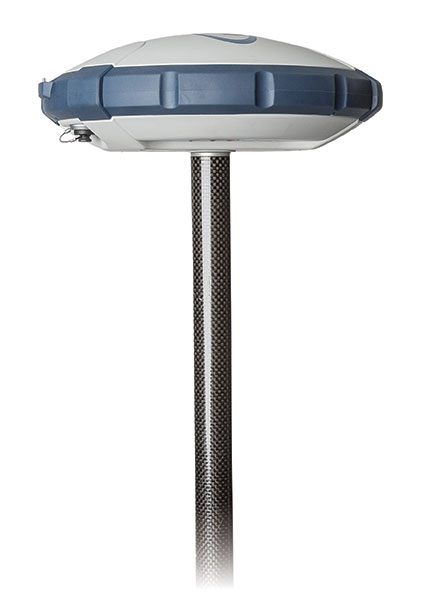
    Spectra Precision SP60.
    Spectra Precision SP60.

    Spectra Precision has introduced its new SP60 GNSS receiver. Designed to meet the evolving needs of surveyors, the SP60 is a versatile solution combining next generation Spectra Precision GNSS technology, a high level of configuration flexibility and an innovative design, the company said. The SP60 is part of Spectra Precision’s latest portfolio of GNSS receivers specifically designed for the mainstream survey and construction applications such as cadastral, topographic, control, stakeout and network RTK.  

    Spectra Precision SP60 features exclusive Z-Blade GNSS-centric technology running on a new-generation, 240-channel 6G chipset. The SP60 is capable of fully utilizing all 6 available GNSS systems (GPS, GLONASS, BeiDou, Galileo, QZSS and SBAS), but can also be configured to use only selected constellations in an RTK solution (GPS-only, GLONASS-only or BeiDou-only). With L-Band capability to enable CenterPoint RTX correction service, the SP60 GNSS receiver can deliver centimeter-level accuracy without terrestrial/cellular network availability. The receiver is optimized to provide high accuracy positioning performance worldwide.

    With its configuration flexibility, the SP60 is scalable and can be used in multiple configurations and operating modes from a simple post-processing solution to a network RTK or CenterPoint RTX capable rover. In addition, the optional transmit radio or embedded Long Range Bluetooth enables the SP60 receiver to be used as a base and rover system. This extended scalability allows surveyors to begin with a simple solution, and through hardware and firmware upgrades, adapt the SP60 to more complex survey jobs.

    The Spectra Precision SP60 is rugged and waterproof, yet compact, lightweight and ergonomic for ease of use in the field. The received also includes a patented inside-the-rod mounted UHF antenna. When the UHF transmit radio module is used, its UHF antenna remains protected inside the rugged rod, extending the radio range performance.

    “The Spectra Precision SP60 introduces a new level of configuration flexibility to the surveying market,” said Olivier Casabianca, business area director of Trimble’s Spectra Precision Division. “The SP60 was designed as an extremely versatile receiver, allowing surveyors to make it suitable for a specific surveying project, and then upgrade it to a more complex solution, when needed.”

  • Augmented-Reality Golf Coverage Uses KVH IMU

    Augmented-Reality Golf Coverage Uses KVH IMU

    Photo: KVH Industries.

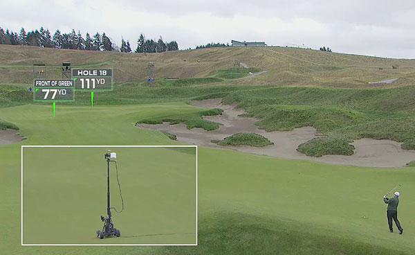
    Golf fans who watched televised coverage of the U.S. Open golf tournament June 18-21 got a new outlook on what the professional golfer is facing, thanks to a camera and augmented-reality tracking system that includes a 1750 inertial measurement unit (IMU) from KVH Industries.

    Called RangeFinder, the system was developed by Sportvision, Inc., creators of football’s Virtual Yellow 1st and Ten Line, in conjunction with FOX Sports, and it debuted during the broadcast of the 115th U.S. Open from Chambers Bay, in University Place, Wash.

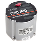
    The KVH 1750 IMU,
    The KVH 1750 IMU,

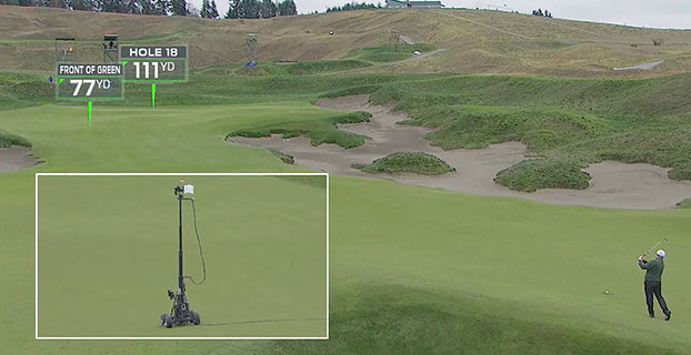
    At the heart of Sportvision’s RangeFinder system is a broadcast-quality camera with a KVH 1750 IMU mounted in a box at the top of the camera; the IMU works in conjunction with a GPS mounted at the base of the camera. By combining data from the IMU and the GPS, the RangeFinder system enables the measurement of the precise location and attitude of the camera; with that information, Sportvision technicians create augmented-reality graphics that indicate how far away a green, sand trap, obstacle or any other feature is located.

    “We selected KVH’s 1750 IMU due to its performance attributes, its size and weight, as well as its cost-effectiveness,” said Mike Jakob, Sportvision president and chief financial officer. “We know this IMU well for what it brings to some of our other products, and we appreciate the reliability and high quality.”

    KVH’s 1750 IMU incorporates three axes of KVH’s DSP-1750, a tiny fiber optic gyro, with three axes of accelerometer technology to create an advanced six-degrees-of-freedom sensor. Designed to integrate easily into demanding stabilization, pointing and navigation applications, the 1750 IMU enhances performance at a lower cost than competing systems, KVH said.

    “Our IMUs and other inertial sensors have been used in several of Sportvision’s innovative products, including the LiveLine system for America’s Cup yacht racing coverage, and we are thrilled to play a role in this new system for golf coverage,” said Martin Kits van Heyningen, KVH chief executive officer.

    The RangeFinder system is designed to enhance the television viewer’s enjoyment of golf competitions by providing more insight into the setting. “The camera is mounted on a mobile tower that can go vertical 20 feet in the air, and that gives the viewer a really unique perspective of the course,” said Ken Milnes, project manager for Sportvision. “With the camera fully instrumented, we can put augmented-reality graphics on the TV screen. We virtually insert a rectangular placard that the TV viewer sees, with a pointer arrow and the yardage to the hole or obstacle.”

    During the U.S. Open, the RangeFinder mobile camera towered were positioned on the fairway for a golfer’s second or third shot on a particular hole; the intent was to provide graphics on the approach shots to the green, rather than on a drive from the tee. Sportvision and FOX Sports worked together for more than a year to develop the new system.

    “For the TV viewer, RangeFinder gives them an angle behind the golfer that they have never seen before,” said Zac Fields, vice president for graphics and technology at FOX Sports Media Group. “One of the advantages of any sports telecast is being able to utilize technologies so the viewer can see things that the athlete cannot. RangeFinder is a great example of being able to provide that kind of insight. We tested this technology at a smaller tournament last month and the initial feedback was extremely positive.”

    KVH’s 1750 IMU marries the E•Core ThinFiber technology of KVH’s DSP-1750 FOG with very low noise, solid-state MEMS accelerometers to create a commercial-off-the-shelf IMU. The 1750 IMU offers exceptional precision in a very small form factor, designed for applications where space is limited such as unmanned and autonomous systems.

    The 1750 IMU is one of a series of three IMUs that KVH has developed to address a wide range of demanding applications, including autonomous vehicles; unmanned aerial surveillance, surveying, and mapping; autonomous research and exploration; humanoid robots; and oil and gas pipeline inspection equipment.

  • Singapore Joins with China to Develop Apps, Protect BeiDou Signals

    Singapore and China are jointly opening a center to develop applications for the BeiDou GNSS, according to a report in Space News. The nations also have signed a commercial agreement to create anti-jamming systems to protect BeiDou signals.

    At a briefing during the CommunicAsia show held in Singapore May 31-June 2, SpaceTime Technology Pte Ltd. and ST Electronics (Satcom & Sensor Systems) Pte Ltd. signed a memorandum of understanding to “develop in Singapore an interference-resistant Beidou satellite positioning system,” SpaceNews report.

    The companies said the goal is to protect BeiDou signals from unintentional jamming in urban environments, where wireless devices occasionally overstep their radio-frequency boundaries.

  • As June 30 Nears, Leap Second Looms

    Leap-Second-O

    The world’s clocks will be adjusted by one second on June 30, when a leap second will be inserted into Coordinated Universal Time (UTC), the standard international time scale.

    In theory, all UTC clocks should insert a second labeled 23h 59m 60s (the leap second) following one labeled 23h 59m 59s UTC. This is equivalent to having all of the clocks in the world stop for one second at that time, as explained in May’s Expert Advice column.

    Several legacy GPS receivers immediately and incorrectly applied a leap second correction as early as January, or showed incorrect leap-second-pending data when queried due to an incorrect interpretation of the GPS specification by the firmware programmers of those GPS receivers, according to Jackson Labs Technologies.

    To help affected industries prepare, the DHS National Coordinating Center for Communications issued guidance with a paper titled “Best Practices for Leap Second Event Occurring on 30 June 2015.”

    The financial market has prepared for potential disruptions. The adjustment could present technical difficulties for traders and exchanges, as some computers might not be programmed to account for the adjustment.

    One company preparing is Racelogicwho makes the LabSat simulator. Racelogic will be recording the leap second as it happens and will then have the scenarios available for customers to replay. A variety of recordings will be taken: GPS, GLONASS, and BeiDou constellations will each be captured as a single channel, and also as a simultaneous triple-constellation recording. These will then be available to use with the LabSat.

    Jackson Labs has released new firmware versions for various products that address any potential issues for the pending and future leap second events, and that add a number of additional commands to query and handle leap second events.

    Precise Time and Frequency, Inc., has published a paper, “Phase Error Correction — Precision versus Speed,” which describes a technique for rapidly eliminating very large phase offsets (up to 0.5 seconds) between two 1 pulse per second pulses. The change is achieved without a sudden step change (which can be unwelcome in numerous applications) while retaining the ability to tune the phase with high precision (resolution of 0.006 pico seconds) once the large error is eliminated.

    “Like many novel ideas, the simplicity of this technique belies its effectiveness,” according to the paper. “With hindsight it seems like an obvious solution; however, the engineering mind is trained to know that to generate a one-second pulse from a reference frequency (in this case 10 MHz), it must be divided by the frequency itself, and the concept of an ‘incorrect’ divisor is not necessarily so obvious. In this case, however, the technique provides an ideal solution that reduces the phase-lock capture time from something that would be intolerable to a very acceptable time period.”

    Download the paper at this link.

  • LabSat’s SatGen v3 Adds BeiDou to Simulator Scenarios

    LabSat’s SatGen v3 Adds BeiDou to Simulator Scenarios

    Photo: LabstatSatGen v3 software is now available for the LabSat GNSS simulator by Racelogic. Version 3 includes BeiDou (BDS) in addition to GPS and GLONASS.

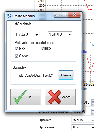
    SatGen is billed as a powerful and intuitive software package that gives users the ability to create scenarios for replay through any LabSat simulator. The software creates either user-generated or imported trajectory files for use with a LabSat simulator.

    The addition of the BeiDou B1 signals means that users can now test a device’s effectiveness as if it were being used within the operating area of the Chinese constellation, which at present only provides full coverage in Asia.

    The BeiDou constellation is set to become globally operational by 2020. With the new SatGen v3, users can create scenarios that include signals from satellites yet to be launched, so new products can be developed in readiness for the full constellation.

    SatGen v3 can produce scenarios with one, two or three sets of signals being simultaneously output: GPS, GLONASS and now BeiDou. The software now matches the record and replay abilities of the LabSat 3 simulator.

    A trial of SatGen is available here. To purchase a full copy contact a LabSat distributor.

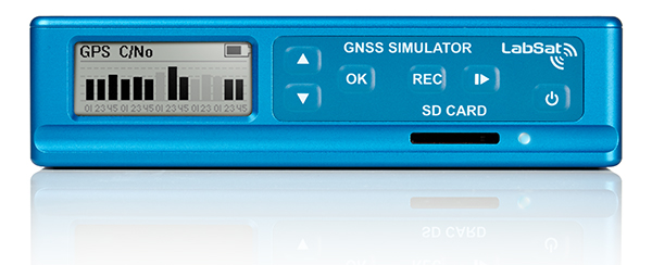
    The LabSat 3 GNSS simulator.
    The LabSat 3 GNSS simulator.
  • Powerful RTK with Six Separate Engines

    Powerful RTK with Six Separate Engines

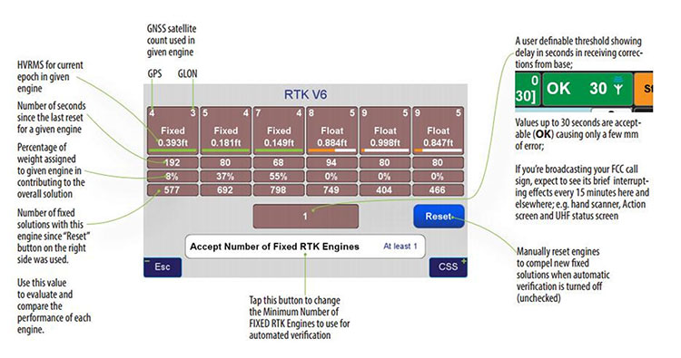
    Screen anatomy — RTK v6.
    Screen anatomy — RTK v6.

    By Matthew D. Sibole

    A little more than a year ago, I became a part of a team of surveyors from across the country to offer testing and input on new technology and programing coming out of JAVAD GNSS. It has been a great honor to work along with Dr. Javad Ashjaee, the other surveyors and Javad’s staff at JAVAD GNSS. Why Javad chose me, I doubt that I will ever know. While I am proud to be a part of what Javad has dubbed “J-Team,” I have realized very quickly how little I know about GNSS. In this series of articles that I plan on putting together, I will chronicle my advances in GNSS and testing of JAVAD GNSS equipment.

    As part of my testing, I have been using a JAVAD Triumph 2 base (with 4-watt external radio) and a TRIUMPH-LS rover. I had seen advertisements for this system for many months prior to becoming a member of the J-team. I was apprehensive at first with the difference in the appearance and learning the new software. However, it did not take long to realize how advanced this system, namely the TRIUMPH-LS, was.

    One key feature that I use to determine the quality of my shots is the V6 engines. The V6 engines that it uses to fix the ambiguities is unlike anything I have seen in any other software or receiver. The V6 engines are six separate RTK engines running simultaneously. Basically, this is like having six separate receivers in one.

    When in heavy multipath area, I tend to stay fixated on this screen. Each engine can fix at different times. When another engine gets fixed, the resulting epochs are averaged between the two fixed engines and so on with any of the other engines. (See above image.)

    This is only one of many technological advancements that Javad has included in his newest receivers. Please continue to follow my articles on other advancements and general surveying practice topics.

    For more information on Javad’s J-Field software, the TRIUMPH-LS or other JAVAD GNSS solutions, please feel free to visit www.javad.com, email [email protected], or call 1-888-550-5301 or 1-408-770-1770.


    Matthew D. Sibole is a Professional Land Surveyor (PLS) and a member of the JAVAD GNSS J-Team.

  • Get Full Advantage from Many Profitable Features In One Compact RTK Rover

    Get Full Advantage from Many Profitable Features In One Compact RTK Rover

    TR-LS-JAVAD-Triumph-W
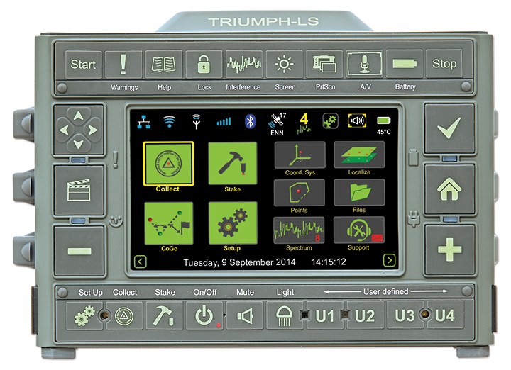
    The TRIUMPH-LS receiver, by JAVAD GNSS.

    The TRIUMPH-LS and its field software, J-Field, have many revolutionary and innovative features compared to current GNSS systems. Here is a quick overview of its most salient features, making it an ideal unit for surveyors in the field and managing from the office.

    The TRIUMPH-LS contains everything needed to function as a complete RTK rover in one small, compact, ergonomic and very portable unit:

    • an 864-channel GNSS receiver
    • a UHF or spread spectrum radio, a GSM modem
    • a Wi-Fi adapter
    • two internal cameras
    • a flashlight
    • a bright 800 x 480 pixel display.

    Also included with the system is a collapsible monopod rover pole which allows the unit to be quickly folded up to fit in a very small space, perfect for carrying the system in the field or quickly stowing inside a vehicle. The lack of a data collector bracketed to the rover pole further increases its portability; the user can carry the system through the woods without having to worry about an extruding data collector getting caught in brush.

    This system was ergonomically engineered; the head-height vertical display allows the user to operate the TRIUMPH-LS while standing in an upright position and looking forward. Users do not need to bend their neck to look down to view the display, as is traditionally done with a system having a data collector attached to a rover pole. This Triumph feature allows the system to be used without the neck soreness that can plague a user after working for extended periods of time.

    The TRIUMPH-LS contains a built-in compass and tilt sensors. The compass enables quick and efficient stake-out of points. Forward/back and left/right offset readings relative to the face of the display show precisely where the stake-out point is located. This stakeout method reduces the time required for this task, compared to using traditional north/south and east/west offsets. The built-in tilt sensors can be used in lieu of having to plumb the rover pole. Taking advantage of the tilt sensors is also a “Lift & Tilt” mode that means topo points can be collected without pressing any buttons. In this mode, when the TRIUMPH-LS is plumbed, a point will automatically start collecting and can be programmed to collect a set number of epochs or to stop collection when the unit is tilted. After the point is collected, the user tilts the TRIUMPH-LS and walks to the next point, which will be collected when the unit is plumbed again.

    Software. The field software, J-Field, is included at no extra charge with the system. There is no need for an external data collector or software. J-Field is constantly being improved, and updates will always be available free of charge with the system.  The updates can be downloaded through Wi-Fi and are very simple to install, requiring only a couple of button presses to update the system.

    J-Field features six separate, parallel RTK engines that all run simultaneously with separate assumptions. This allows for fixes to be obtained quicker than if only a single RTK engine were used. It has an advanced RTK verification system that can be used in difficult RTK environments where there is high multipath and/or tree canopy cover. This process will automatically reset the RTK engines and eliminate points from being collected with bad RTK fixes that often plague other systems in difficult locations.

    With the built-in GSM modem, it is very easy to connect to real-time networks (RTNs). Alternately, it can also be connected through Wi-Fi using a mobile hotspot.

    Full CAD features are in the process of being developed for use with the map screen. The ability to draw lines, polylines, circles and arcs will be supported. Using the planned move, copy, offset and rotate commands, much of the same CAD work that is traditionally done in the office will now be able to be completed in the field. This very beneficial feature can reduce the number of return visits to a project site.

    J-Field has many customization features that can be used to increase productivity as your knowledge of the system grows. The stake and collect screens have eight white boxes that are easily customized to display a number of fields that the user may desire.

  • Drone Delivery Test Event to Focus on Medical Service

    Drone experts will join with those from the medical field in a demonstration July 17 in Wise, Va. The event, “Let’s Fly Wisely,” aims to show how unmanned aerial systems (UAS) can alleviate the problem of health care access while creating economic opportunity for communities.

    Many people in Virginia and across rural America are beyond reach of essential health services and basic supplies, ranging from bandages to medicine, according to event organizers. The drones will deliver essential medical supplies to an annual medical clinic held at the Wise County Fairgrounds every summer, organized by Remote Area Medical (RAM) USA and the Health Wagon.

    At the clinic, thousands of medical specialists provide free eye, dental and health care services to people in urgent need, in what event organizers say is the largest free health care outreach in the nation.

    The UAS used for the demonstration will be a completely autonomous rotorcraft, designed by Flirtey, capable of delivering small payloads of drugs and medical equipment to isolated areas, and a larger, fixed-wing aircraft operated by NASA Langley Research Center, capable of carrying up to 600 pounds of cargo.

    The most urgent prescriptions will be provided from pharmacies located out of town, reports Startup Daily. To get the medicine to the community as soon as possible, the pharmacies will deliver them to their local airport, where they will be collected by NASA’s fixed-winged aircraft and flown to Lonesome Pine Airport. When the prescriptions arrive there, they will be loaded onto Flirtey drones and delivered to the Wise County Fairground. Flirtey drones are expected to deliver around 24 packages of prescription medication.

    The FAA-approved research flights will put UAS technology to work for medical relief, to show how unmanned aircraft can help health professionals provide care more easily and efficiently, closing the gap between those who can offer medical help and those who need it most.

    “In doing so, we will demonstrate the promise of a technology that offers a bright future for our youth — right here in Virginia, where Wise County is rapidly becoming a center for technology manufacturing and testing. We believe Let’s Fly Wisely is much more than a novel use of technology in healthcare. It is an example of the self-reliance, ingenuity and wherewithal of the American people and Virginians in particular,” organizers said.

    The collaboration includes nonprofits, universities, corporations and government organizations, including Virginia Tech Institute of Critical Technology and Applied Sciences. The Federal Aviation Administration selected Virginia Tech in December 2013 as one of six national test programs to conduct research on integrating unmanned aircraft into the nation’s airspace.

    Other partners include:

    • The Appalachian College of Pharmacy
    • Flirtey, Inc.
    • Health Wagon
    • The Mid-Atlantic Aviation Partnership
    • NASA Langley Research Center (pending approval of the Space Act agreement between NASA Langley Research Center and Virginia Tech)
    • Remote Area Medical
    • Rx Partnership
    • SEESPAN, Inc.
    • Wise County Economic Development

    The video below shows how Australian start-up Flirtey delivers packages with its drones.

  • NovAtel G-III Reference Receiver Technology Chosen for QZSS

    NovAtel G-III Reference Receiver Technology Chosen for QZSS

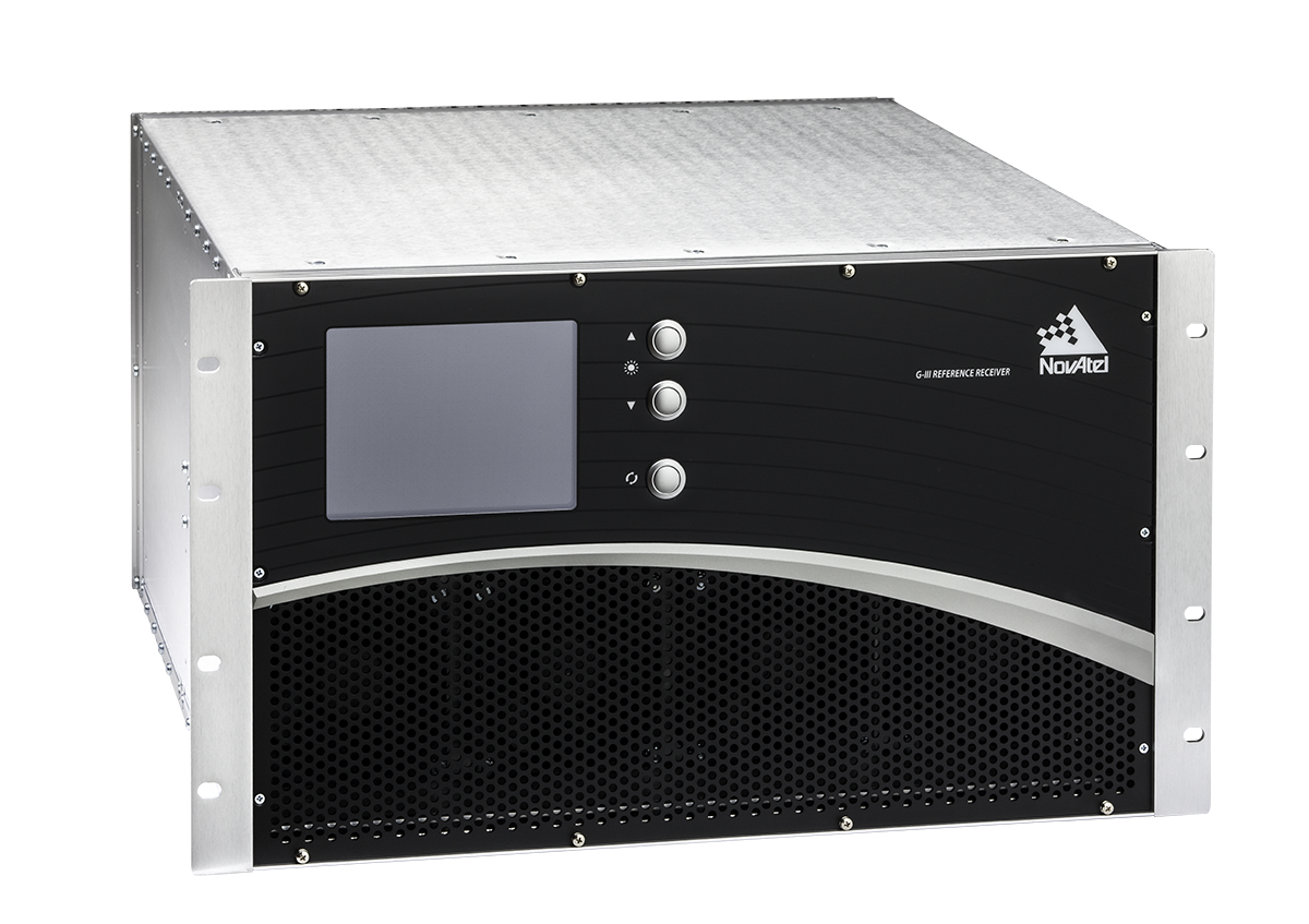
    The NovAtel G-III receiver.
    The NovAtel G-III receiver.

    NovAtel Inc. has entered an agreement with NEC Corporation to supply reference receiver products for use in the Quazi-Zenith Satellite System (QZSS). QZSS is Japan’s regional satellite-based augmentation system.

    The NovAtel receivers to be used by QZSS are based on the company’s third-generation (G-III) family of reference receivers. Designed for integrity monitoring and reference measurement applications, the receivers track signals independently to provide precise code- and carrier-phase reference measurements as well as signal quality measurements and other integrity monitoring metrics. Housed in a 19-inch rack-mount enclosure with AC power supply and integral cooling fans, the G-III reference receivers provide continuous, reliable operation in a reference station environment, NovAtel said.

    The G-III receiver platform has been customized to meet the needs of individual satellite networks. In addition to the QZSS G-III product, NovAtel supplies WAAS G-III reference receivers to the U.S. Federal Aviation Administration’s (FAA’s) modernized Wide Area Augmentation System (WAAS) network and IRNSS G-III reference receivers for the ground control segment of the Indian Regional Navigation Satellite System (IRNSS).

  • Averna Launches RF Record & Playback with Real-Time GNSS Simulator

    Averna Launches RF Record & Playback with Real-Time GNSS Simulator

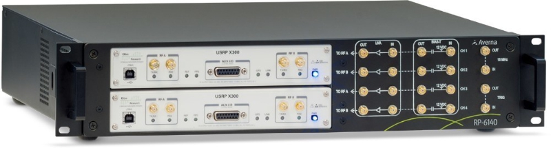
    Averna RP-6100 Series (PRNewsFoto/Averna).
    Averna RP-6100 Series (PRNewsFoto/Averna).

    Averna has launched an RF tool offering high-performance record-and-playback and real-time simulation in one platform.

    The Averna RP-6100 series is a self-contained, record-and-playback solution for RF application validation. It can capture all GNSS bands, as well as HD Radio, Wi-Fi, LTE, radar, and cognitive radio — plus impairments — to significantly advance RF projects and harden product designs. The RP-6100 series features up to four channels, 160 MHz of recording bandwidth, tight channel synchronization, an extended frequency range of 10 MHz to 6 GHz, and 14-bit resolution.

    The RP-6100 can also be equipped with Skydel Solutions’ software-defined, real-time GNSS simulator, which delivers easy setups, integrated maps, dynamic scenario creation, high precision and tight parameter controls to enable highly repeatable simulations of current and future GNSS conditions, as well as corner cases.

    Features include:

    • Frequency range of 10–6000 MHz, covering all GNSS bands, plus HD Radio, WiFi, LTE, and more
    • Multi-channel (1-4): Up to 160 MHz of bandwidth at 14-bit resolution (< 1 Hz)
    • 3.8 TB SSD storage or 16 TB HDD storage (for up to 22 hours of recordings)
    • Preloaded with RF Studio software for quick setups and in-depth analysis
    • Four models: RP-6120 (2 ch.), RP-6120P (2 ch. portable), RP-6120D (2 ch. desktop) and
      RP-6140 (4 ch.)
    • Optional real-time Skydel GNSS Simulator for complete GNSS corner-case/testing scenarios

    “We are very excited to partner with Skydel Solutions as a way to continue to provide our customers with the latest technologies and products,” said Benoit Richard, VP of Innovation & Strategy at Averna. “Their technology maps perfectly with our portfolio of RF instrumentation solutions, which empower device manufacturers to efficiently generate, record, simulate, analyze, and play back all common radio, video, and navigation signals, ensuring complete test coverage and the highest quality for their RF products.”

    “Today, Skydel is proud to introduce its software-defined GNSS Simulator, running in real-time Ettus and NI USRP hardware,” said Stéphane Hamel, co-founder and CEO of Skydel Solutions. “We are also very pleased to announce that our GNSS Simulator can be combined with Averna’s RP-6100 Series. These technologies complement each other perfectly, making the combined solution the ideal platform for high-performance design validation of RF and GNSS devices.”

  • Pinnacle Uses Leica System to Keep NYC High-Rise Plumb

    Pinnacle Uses Leica System to Keep NYC High-Rise Plumb

    Photo: Leica GeosystemsWhen the new Extell luxury high-rise building goes up at 217 West 57th Street in Manhattan, the vertical alignment of the core-wall structure will be crucial to success. This internal core structure will rise almost 1,500 feet above the ground and will be the reference for all other building construction, making its construction one of the most mission-critical aspects of the entire project, according to Leica Geosystems.

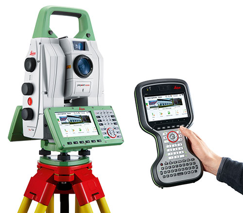
    Pinnacle Industries, the concrete contractor responsible for building the structure, has invested in an innovative core-wall alignment system. Consisting of advanced GNSS and robotic total station solutions, the Vertical Alignment System from Leica Geosystems will be used as each floor is constructed to ensure the overall vertical geometry of the structure. High-end training from Leica Geosystems will provide the support and knowledge transfer needed to achieve successful adoption of this innovative approach.

    The project is noteworthy for a number of reasons. With an overall roof height of 1,479 feet (1,775 feet to top of spire), the new building will dominate the Midtown skyline and will be the tallest residential building in the world. It will also mark the introduction of Nordstrom Inc. to New York City. The architect of record, Adrian Smith + Gordon Gill Architecture, is the firm behind Dubai’s Burj Khalifa, the tallest commerical building in the world.

    According to David Rutledge, director of structural monitoring for Leica Geosystems’ Monitoring Solutions business in North America, Pinnacle Industries chose the Leica Geosystems Vertical Alignment System for its ability to reliably and quickly make alignment adjustments to the forming traveler that will be used to construct each floor. The Leica GM10 GNSS instruments in particular were chosen for their ability to produce highly accurate 3D position coordinates.

    “It’s very exciting to be involved with the soon-to-be tallest residential building in the world,” Rutledge said. “Pinnacle is an industry leader in this type of construction, and we feel honored to have been selected by the team. Leica Geosystems’ solutions provide exceptionally high accuracy and outstanding performance, making them ideally suited for the high productivity demanded on projects like this. We’re thrilled to be able to play a supporting role in this significant and historic project.”