Author: GPS World Staff

  • GeoLearn Adds Nine Geodesy Courses by David Doyle

    GeoLearn Adds Nine Geodesy Courses by David Doyle

    David Doyle
    David Doyle

    GeoLearn, a company focused on serving the geospatial industry with video-based online learning and continuing education credits, has added nine courses on geodesy topics by retired NGS Chief Geodetic Surveyor and GPS World contributor David Doyle.

    Doyle is a contributing editor for survey to GPS World’s monthly Survey Scene newsletter. His first column appeared in May.

    GeoLearn’s new introductory geodesy courses carry approval for professional development hours (PDHs) from the ABET-accredited geospatial program at Texas A&M University-Corpus Christi.

    “I’ve been addressing groups of surveyors and other professionals who use NGS data. In these courses, I take those decades of interaction and try to anticipate and address the most common problems they’ve encountered and most of the questions they would ask,” Doyle said.

    Doyle’s first eight courses are offered as a series, though students can pick and choose. The first is an introductory stage-setting course on geodetic fundamentals for those who have been hesitant to delve into any geodesy-related topic. It is an excellent primer for a broad spectrum of geospatial professionals and technicians in fields such as land surveying, engineering and technical GIS applications. The rest of the series includes two on classical horizontal datums and contemporary horizontal datums and two on vertical datums. He includes an additional course on future datums and another on coordinate systems.

    Doyle’s ninth course uncovers the “secret sauce” to understanding and using NGS data sheets. It helps novices and experienced alike to understand all the clues and guideposts embedded in such sheets. He includes a discussion of how to understand the accuracy (horizontal and vertical) of various marks based on the metadata provided right in the data sheet. Also included is information on how to access photographs of the marks and how you can update the information using a simple program that you can download from the NGS website.

    “Dave was of phenomenal service to geospatial professionals when he was with NGS,” said Joe Paiva, CEO of GeoLearn. “We are proud to be the only 24/7 education source that delivers Dave’s quality, video-based education on these needed topics.”

  • UNB’s PPP Software Centre v2.0 Beta Now Available

    The PPP Software Centre, an email-based Online PPP comparison utility hosted by the University of New Brunswick, is once again functioning with its release of version 2.0 Beta following an extended hiatus while being rewritten.

    The centre is a convenient method for the GNSS community to compare results from several online precise point positioning services. For a more detailed description, including submission instructions, see the homepage at http://www2.unb.ca/gge/Resources/PPP/.

    Note that the report has changed slightly, adding additional features, including final static position estimates tabulated in both Cartesian and geodetic coordinate systems; the name of the Cartesian system (and its epoch); and featuring a so-called Subject Line Interface, allowing advanced users some additional control over the centre’s behavior. This last feature may see some future expansion.

    The centre invites feedback on the utility.

  • Companies Team on UAS Imagery for Pipelines, Electric

    Flightline Geographics and Tablerock Land Survey have partnered to provide industry-leading premium 3D aerial imagery from Unmanned Aerial Systems (UAS) for pipeline and electric transmission projects across North America. The announcement was made at the International Right of Way Association annual conference and trade show.

    FlightlineGeo is a GIS company that has been involved in professional UAS since 2012 and is able to provide base mapping and 3D terrain modeling through the use of drones for energy corridors and other areas of interest. Resolution and delivery times are far better than traditional manned sources and costs are significantly lower. “GIS is a technology that depends upon up-to-date content and UAS is now a cost-effective way to provide aerial visual intelligence for GIS, in the form of stunning 3D Imagery. All delivered in days, not months,” said FlightlineGeo Founder and CEO Devon Humphrey.

    Tablerock provides complete survey, right-of-way, and project management/inspection services for projects of all sizes. “One of the challenges we have faced has been obtaining current aerial imagery and topographic information that meets industry needs for project design and GIS within the United States. On most projects, our clients are limited to whatever current satellite imagery is available on the Internet, but it is often dated and of low quality. Content from FlightlineGeo changes all that,” said Andrew Darlington, President of Tablerock Land Survey.

    FlightlineGeo is an ESRI Partner Network Company based in the Austin, Texas, area, and Tablerock Land Survey is based in Denver, Colo.


  • CHC Introduces UAV Ground-Control Specific GNSS System

    CHC Introduces UAV Ground-Control Specific GNSS System

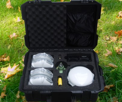
    The UAV Ground Control (UAV GC) and post-processing kit for high-precision UAV systems by CHC Navigation.
    The UAV Ground Control (UAV GC) and post-processing kit for high-precision UAV systems by CHC Navigation.

    CHC Navigation has launched a new UAV Ground Control (UAV GC) and post-processing kit for high-precision UAV systems. This kit is designed to provide an easy-to-operate complete system, and be cost-effective for producing centimeter-level control for UAV projects.

    The standard kit includes five GNSS receivers with expansion of additional receivers in pairs. The core of the system is the X900+OPUS, a dual-frequency triple-constellation receiver capable of cm positioning of the project at 200 km in absolute geodetic space. The secondary X20+ receivers serve as ground-control points for orthorectification, project verification, and other high-accuracy positional tasks.

    Photo: CHC Navigation“Low cost and easy to use, the CHC UAV GC system is a necessity for any UAV manufacturer or operator who is interested is promoting/proving the high accuracy of their deliverables,” said George Zhao, CEO of CHC Navigation. “The UAV Package offers unrivaled performance at an unheard of low price, and fills the last remaining gap for a complete whole product solution in the UAV market.”

    The UAV GC kit is now available through the existing CHC distribution channel worldwide.

  • MEMSIC Launches Inertial System with GPS

    MEMSIC Launches Inertial System with GPS

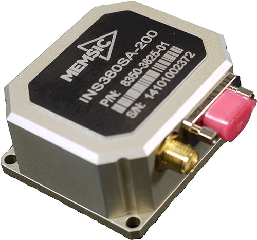
    The MEMSIC INS380SA.
    The MEMSIC INS380SA.

    MEMSIC has launched its latest inertial system, the INS380 — a complete inertial navigation system with a built-in 48-channel GPS receiver. The INS380 is part of a portfolio of inertial systems enabled with MEMSIC’s SmartSensing technology for a broad range of precision-motion sensing applications.

    The MEMSIC portfolio consists of inertial measurement units (IMU), vertical gyros (VG), attitude and heading reference systems (AHRS), inertial navigation systems (INS) and tilt measurement systems in a variety of packages for system designers and end-equipment manufacturers.

    The SmartSensing technology enables a turnkey system with better than 0.01 m/s velocity measurement accuracy. The integrated 3-axis magnetometer allows for accurate operation when the GPS signal is lost or when the vehicle comes to a stop. SmartSensing provides users with sensor fusion and performance in critical motion sensing applications.

    SmartSensing combines enhanced and patented Kalman-based algorithm with proprietary temperature, motion and alignment calibration for consistent and high-accuracy performance over a wide range of extreme operating conditions. Applications include unmanned ground and aerial vehicles, platform stabilization, avionics, precision agriculture, construction and more.

    INS380SA-400 EVALKIT is available for evaluation and ships completer with an INS380 unit along with necessary accessories for quick installation. Designers can evaluate and configure the system using MEMSIC’s NavView Software, available for download.

  • Highest Peak in North America to be Surveyed

    Highest Peak in North America to be Surveyed

    At 20, 320 feet, Mount McKinley is North America’s highest peak. (Photo courtesy of Todd Paris, UAF).
    At 20, 320 feet, Mount McKinley is North America’s highest peak. (Photo courtesy of Todd Paris, UAF).

    A new GPS survey of Mount McKinley, the highest point in North America, will update the commonly accepted elevation of McKinley’s peak, 20,320 feet. The last survey was completed in 1953.

    The USGS, along with NOAA’s National Geodetic Survey (NGS) and the University of Alaska Fairbanks (UAF), are supporting a GPS survey of the Mount McKinley apex. Surveying technology and processes have improved greatly since the last survey and the ability to establish a much more accurate height now exists, the USGS said.

    The Mount McKinley survey team, and their equipment, are expected to face temperatures well below zero, high winds and frequent snow. Current forecast, courtesy of NOAA. (Photo courtesy of Todd Paris, UAF).
    The Mount McKinley survey team, and their equipment, are expected to face temperatures well below zero, high winds and frequent snow. Current forecast, courtesy of NOAA. (Photo courtesy of Todd Paris, UAF).

    An experienced team of four climbers, one from UAF and three from CompassData, will start the precarious trek to the summit with the needed scientific instruments in tow, in the middle of June. They plan to return on or before July 7 and begin work with the University of Alaska Fairbanks and NGS processing the data to arrive at the new summit elevation.

    With the acquisition of new elevation (ifsar) data in Alaska as part of the 3D Elevation Program, there have been inquiries about the height of the summit. The survey party is being led by CompassData, a subcontractor for Dewberry on a task awarded under the USGS’ Geospatial Products and Services Contract (GPSC).

    Using modern GPS survey equipment and techniques, along with better gravity data to improve the geoid model in Alaska, the partners will be able to report the summit elevation with a much higher level of confidence than has been possible in the past.

    According to CompassData, the survey equipment includes two Trimble R10 antennas and one Trimble Net-R9 with a Zephyr-2 antenna. Also being taken up the mountain is a 10-meter specialized glacier avalanche probe and a Ground Penetrating Radar (GPR), courtesy of the University of Alaska Fairbanks.

    It is anticipated the newly surveyed elevation will be published by the National Geodetic Survey in late August.

    Climbing Mount McKinley, North America’s highest peak, is a daunting task for even the most experienced mountaineers at Denali National Park in Alaska. (Photo courtesy of National Geographic).
    Climbing Mount McKinley, North America’s highest peak, is a daunting task for even the most experienced mountaineers at Denali National Park in Alaska. (Photo courtesy of National Geographic).

  • June Webinar to Focus on Autonomous Driving

    Autonomous vehicles — and the technology that will make them possible — are the focus of the June GPS World Market Insights Webinar. The Road to Driverless: Autonomous Vehicle Platforms, Sensors and Requirements will be held Thursday, June 18, at 1 p.m. EDT/10 a.m. PDT. Registration is free.

    Advanced driver-assistance systems (ADAS) are now integrated in all luxury cars and moving into mainstream models. Governments are getting involved to prevent accidents and minimize the related economic impacts with them. Manufacturers are not far behind; every one of them wishes to be seen as a technology master. Most car and truck companies are working actively on qualifying fully driverless technology today. The military also has a high interest in this area, and has developed autonomous convoy capability for large trucks and supply vehicles.

    Although no driverless car is expected to operate freely on public roads for the next 10 years, some open test drives have already taken place, including one 100-mile highway cruise by a driverless Mercedes. This technology is restrained by legal issues and the lack of reliable nationwide mapping data — but the platforms are nearly ready to go.

    Join us as we explore the current state of affairs and the likely near-term future developments.

    Speakers:

    John Fischer, Chief Technology Officer, Spectracom
    Fischer has more than 30 years experience creating navigation and communications systems, received his Masters in electrical engineering from SUNY at Buffalo and has worked in radar, command and control, and wireless systems prior to joining Spectracom. To learn more, visit www.spectracom.com.

    Lisa Perdue, Applications Engineer, Spectracom
    Perdue is an applications engineer at Spectracom and a specialist in GNSS simulation. She has more than 15 years of navigation and RF systems experience, including 10 years of Naval Service.

    Topics:

    • Accurate positioning of ADAS vehicles on the test track using similar methods as used in military UAVs – John Fischer
    • GNSS and Hybrid Navigation Testing Issues for ADAS and Driverless Cars – Lisa Perdue
    • Realtime Testing Issues for V2V and V2X for ADAS and Driverless Cars – John Fischer 

    Register today. The webinar is sponsored by NavCom.


  • Septentrio Completes Acquisition of Altus Positioning

    Septentrio Satellite Navigation has completed the acquisition and integration of Altus Positioning Systems. Septentrio said the acquisition strengthens the company’s focus on highly accurate and reliable GPS/GNSS positioning equipment, and the integrated company will continue to focus on developing emerging markets across the globe and increase advancements in the field of GIS.

    “At the heart of this fusion are our customers,” said  Antoon de Proft, CEO and president of Septentrio, “They will benefit from this unique opportunity, which combines the knowledge and experience of Septentrio in GNSS positioning with experience of Altus-PS in survey, mapping and GIS; and from an expanded offering of products and services under one group.”

    Septentrio Satellite Navigation and Altus-PS started working together in 2007. The collaboration between the two companies resulted in a series of successful products such as the APS-NR2, APS-3, APS-U and APS-GeoPod, surveying and GIS products that provide essential accurate and reliable results and ease of operation, Septentrio said in a statement. The smart antenna products will form a product line in the Septentrio product portfolio.

    The acquisition brings key capabilities and synergies in other areas such as testing, manufacturing and delivery, which will now be based from Septentrio’s corporate headquarters outside the Belgian city of Leuven.

    Neil Vancans
    Neil Vancans

    Neil Vancans, formerly president of Altus-PS, now becomes vice president of Septentrio Americas. “The fusion of our two companies is a logical step in our evolving business relationship and professional collaboration,” Vancans said. “We look forward to leveraging the strengths of both our organizations to grow the market for Septentrio products across a wide range of market sectors and build the same level of success for Septentrio products in the American market that we have enjoyed elsewhere in the world.”

    Septentrio designs, manufactures and sells high-precision multi-frequency, multi-constellation GPS/GNSS equipment used in demanding applications in a variety of industries such as marine, construction, agriculture, survey and mapping, GIS and UAVs. Septentrio receivers are available as OEM boards, housed receivers and smart antennas.

  • Hemisphere GNSS Debuts Atlas GNSS Correction Service

    Hemisphere GNSS Debuts Atlas GNSS Correction Service

    Atlas_Graphics-1-W

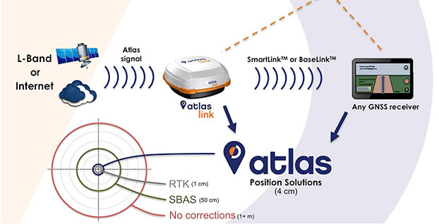
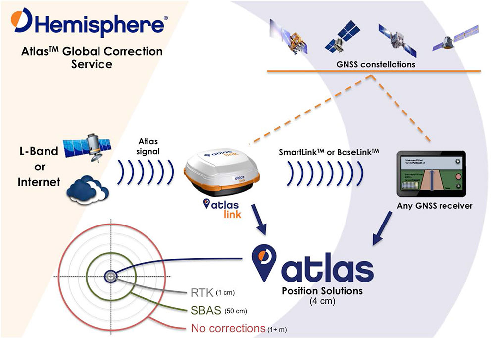
    Hemisphere has released Atlas, its new entrant into the GNSS global correction services market. Atlas is delivered via L-Band or the Internet at accuracy levels ranging from meter level to sub-decimeter level. Atlas support is being introduced across a wide range of hardware, including Hemisphere’s new AtlasLink smart antenna, also launched.

    “Atlas comes out of a change of culture and focus,” Hemisphere CEO Chuck Joseph told GPS World in an extensive interview that also included Rodrigo Leandro, Hemisphere’s director of engineering, GNSS Positioning Systems. For the full interview, see the second half of this news story.

    Starting June 19, Atlas will be available for subscription at the dedicated Atlas web portal across a range of Hemisphere’s multi-frequency, RTK-capable products, such as AtlasLink, R330u, V320 and VS330u. Atlas will also be available from a number of Hemisphere’s channel partners and OEMs such as Carlson Software, Inc.

    “Since joining Hemisphere I have heard from customers large and small that they need a different option when it comes to high-accuracy corrections, one they can buy from their provider of choice and with little to no impact on their operating budgets,” said Chuck Joseph, Hemisphere GNSS CEO and president. “We listened hard to what they told us and built Atlas to answer their needs — a totally new service that delivers freedom of choice to our customers along with industry leading corrections at dramatically reduced prices.”

    “We formed a team of our most experienced GNSS professionals with the task of developing a roadmap for the future of correction services business and technology in the world — assessing current needs, and also what users across the globe will be looking for over the next decade or two,” said Rodrigo Leandro, Hemisphere director of engineering. “Atlas not only introduces Hemisphere as a business and technology leader in the correction services industry today, it also provides an essential platform for delivering multiple levels of correction services to a very wide range of users spanning commercial business and consumer application use.”

    Systems supporting Atlas utilize the newly released and proven Athena GNSS engine. To be able to utilize Atlas corrections, users of supported systems will simply need to update to Athena firmware and purchase a subscription through the Atlas portal.

    To build Atlas, Hemisphere GNSS put together a team of seasoned developers whose collective experience matches the best in the GNSS industry. Together they have developed a GNSS correction service, available via L-Band satellite broadcast, which utilizes the most powerful technologies available to deliver a service that matches or exceeds competitive systems across a range of metrics:

    • Positioning accuracy: Atlas provides competitive positioning accuracies down to 2 cm RMS in certain applications.
    • Positioning sustainability: Position quality maintenance in the absence of correction signals, using Hemisphere’s Tracer technology.
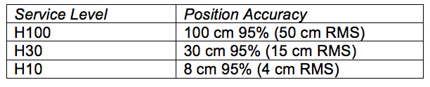
    • Scalable service levels: Atlas is designed to serve all. It is capable of providing virtually any accuracy, precision and repeatability level in the 5 to 100 cm range.
    • Convergence time: Convergence times of 10-40 minutes.
    • Exclusive agnostic capability: Atlas is an agnostic positioning system. SmartLink technology allows an AtlasLink antenna to be used as an Atlas signal extension for any GNSS system compliant with open communication standards.
    • Network RTK augmentation: BaseLink technology allows Atlas-capable receivers to self calibrate, self-survey, and automatically manage the transmission of RTK correction data to augment or extend established or new GNSS reference networks in areas of poor Internet connectivity.
    Hemisphere-Atlas-table
    “High-quality corrections are essential to our customers,” said Randy Noland, director of Machine Control, Carlson Software, Inc. “The way all the existing services are purchased, delivered and supported is completely separated from the rest of the positioning ecosystem. We see Atlas as an opportunity for us to deliver corrections under our own brand as part of a holistic package — all of which means empowering our ability to provide a stronger solution and a better experience for our customers.”

    “Atlas completely changes how augmentation services are delivered and supported,” said Andy Smith at Saderet Ltd. “For the first time, distributors and dealers can fully participate in selling to and supporting our customers, strengthening our relationships by providing them with a much better experience.”

    “I’ve extensively tested Atlas, and the performance is exceptional, making it a great fit for our GIS and survey customers” said Jean-Yves Lauture at Eos Positioning Systems, Inc. “Even better, we can now offer global augmentation services with our Arrow GNSS receivers to our customers as part of an integrated solution. After many years in this industry, that’s a major change.”

    Atlas service levels and position accuracies can be customized to meet OEM needs, the company said.

    Exclusive Interview with Hemisphere’s Chuck Joseph and Rodrigo Leandro

    A Startup Inside a Reinvention

    “Atlas comes out of a change of culture and focus,” Hemisphere CEO Chuck Joseph told GPS World, in an extensive interview that also included Rodrigo Leandro, Hemisphere’s director of engineering, GNSS Positioning Systems. “We are reinventing a storied brand, and to do that we have to act more like the startups I have directed since leaving Trimble — move fast, be flexible, and focus on innovation. Effectively we are building a startup inside of a reinvention.”

    “On my first day on the job, we divided the staff into five working groups and told them: you are now startup companies, entrepreneurs, with six people each team. Go away and come back with big ideas. Go build a business plan. Out of that we got Athena, released last month, Atlas, AtlasLink, and a couple more new products coming out in the months to come.”

    A Different Kind of Corrections Service

    Joseph and his colleagues at Hemisphere describe the distribution, pricing, and overall business model of Atlas as “disruptive.”

    “Our approach comes directly from talking to customers in agriculture, machine control, and to our channel partners. Other corrections service providers did not allow them to participate, forced them to give up their end user list, and to buy directly from [the service provider] — who in some cases was their competitor in that market.”

    “When you step back you can see the impact of those restrictions — after 10 plus years the corrections service marketplace generates probably $150 million in total revenue — it should be bigger than that by now. We think a different approach combined with a very aggressive price point will substantially broaden the marketplace.”

    “We’ll be making announcements of OEM signings in the months to come. For us it’s all about what works for our partners — some of them will private-label the service, some will choose to use the Atlas brand. We really don’t care if our name is on the product or not — we’re an OEM play. Whatever brand they choose, we will provide them with the infrastructure to be successful, even down to the portal their customers will use to manage their devices and subscriptions — we will develop that for them, and provide the back-end e-commerce.”

    A Look at the Technology

    Rodrigo Leandro added, “The basic architecture is not extremely different from other L-band reference services. However, within that, we have really pushed to develop leading-edge technology. For example, our correction method format is well-developed for new constellations and different applications it can serve, and our corrections message structure is the most advanced of those available today. As a result, we have a number of patents pending on technologies included in Atlas.”

    Chuck Joseph interjected, “When we were doing the initial planning for Atlas we agreed that it was absolutely critical that our performance meets or beats the competition’s, otherwise we wouldn’t want to offer it to customers out there. We have been benchmarking the competition at every stage of our development, and know that we are delivering a market leading product.”

    “This slide shows the same, single antenna connected to Atlas and to a competitor, and it shows being able to converge down to decimeter level.
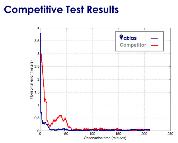
    Chart: Hemisphere GNSS

    “This one gives more details on time to converge.
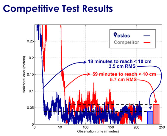
    Chart: Hemisphere GNSS

    “And here, this one shows pass-to-pass results, the relative accuracy between 2 tracks of the tractor — this is important for people more interested in agriculture applications. We can get down to 2.5 centimeters.”
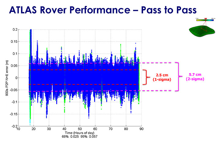
    Chart: Hemisphere GNSS

    “The new AtlasLink antenna is designed to be a main channel for customers of our service. It can be used in GIS, machine control, marine applications and so on. Features inside it include a very big internal memory storage, a web server application, multi-GNSS multi-frequency capability, L-band and RTK — it supports Atlas and Athena out of the box. Other innovations will come later, for instance, incorporating Galileo. We believe it is the most powerful multi-purpose GNSS smart antenna in the industry.”

    “At the same time there is easy support and easy configuration by the user. It takes literally about six clicks from log-in to register the receiver, out of the box. In 20 minutes you’re running Atlas. It’s very easy to get up and running.”

    Broadening the Market

    Leandro continued, “The Atlas service isn’t the only area of innovation however. We also spent a lot of time working on how we could deliver the service to the broadest possible audience, and the resulted in two key features of our AtlasLink antenna — SmartLink and BaseLink. Those features free customers from the restrictions of their current hardware and current service — they really change the game.”

    “Customers don’t want to have to buy a new $10-$20K receiver [in order to get a corrections service]]. If you’re happy with the hardware you’re currently running, there’s no need to change it, you can still get this service. We are not in the business of using the service to sell hardware. We are using the hardware to sell the service.”

    Joseph concluded, “This is all good for OEM customers. For them the SmartLink and BaseLink capabilities are huge. They can go back into their installed base and not have to push people to upgrade receivers or get a brand new receiver. At the same time, it enables them to go after their competitors installed base, and opens up markets that previously weren’t available such as recreational marine service, for example, the lower end of the marketplace. Fundamentally, we want to change this market — enable more users to get access to correction, and deliver real choice to those that have it already.”

     

  • Raytheon Demonstrates Advanced GPS OCX Capabilities

    On June 3, Raytheon demonstrated the advanced capabilities of the GPS Next Generation Operational Control System (GPS OCX) to key U.S. Department of Defense  (DoD) and other stakeholders through a series of realistic operational demonstrations.

    The demonstrations, which incorporated software that will be delivered with the Launch and Checkout System, validated how automation will improve system efficiency and effectiveness.

    GPS OCX is the ground-based command and control system that will manage GPS satellites with significantly improved accuracy and precision, while providing unprecedented levels of cyber protection.

    “These successful demonstrations incorporating actual GPS OCX software reflect Raytheon’s significant and continuing progress on this program and the growing maturity of this very complex system,” said Dave Wajsgras, president of Raytheon’s Intelligence, Information and Services. “Once delivered, this pathfinding, cyber-hardened ground system will significantly enhance the capabilities GPS brings to military, civil and commercial users worldwide,” said Wajsgras.

    The demonstration provided DoD and other stakeholders with a look at how OCX will automate many tasks currently performed manually, resulting in reduced opportunities for error and increased operational tempo for delivering military and other applications, Raytheon said.

    Raytheon demonstrated the benefits of OCX in providing new high-power, jam-resistant military signal known as M-code, as well as the system’s unprecedented cyber automation, detection and response capabilities.

    Raytheon is installing the Block 0 Launch and Checkout System (LCS) hardware at Schriever Air Force Base. LCS software, which includes the cyber-hardened infrastructure for OCX Block 1, is in the qualification test phase and is on track for delivery in mid-2016.

  • Trimble Expands UAS Portfolio with Mutlirotor Partnership

    Trimble Expands UAS Portfolio with Mutlirotor Partnership

    Trimble displayed the Multirotor G4 Surveying Robot at the AUVSI Unmanned Systems Show in May.
    Trimble displayed the Multirotor G4 Surveying Robot at the AUVSI Unmanned Systems Show in May.

    Trimble is partnering with unmanned aircraft system (UAS) manufacturer Multirotor service-drone, GmbH. The collaboration will allow Trimble to expand its existing UAS portfolio to provide its customers with additional solutions to choose from based on their aerial imaging project needs.

    Multirotor service-drone, based in Germany, is a manufacturer of multirotor systems. Trimble will be Multirotor service-drone’s exclusive provider of multirotor vehicles for aerial mapping use in surveying, construction, mining, agriculture, oil and gas, and utilities. The combination of Multirotor service-drone’s stable and reliable platforms with Trimble’s industry-leading sensor technology and workflow efficiencies will provide customers with best-in-class solutions for aerial data capture.

    Unmanned multirotor systems are powerful solutions for visually documenting smaller areas, vertical structures or environments where holding position is important. High-resolution imagery, orthophotos, terrain models and normalized difference vegetation index (NDVI) map deliverables created from multirotor data provide valuable information for the survey, engineering and agriculture industries that Trimble serves, the company said.

    “We are very excited to partner with Multirotor service-drone. At Trimble we’re always looking for ways to meet our customer’s needs and enable them to solve the complex problems they encounter every day,” said Todd Steiner, product marketing director in Trimble’s Geospatial Division. “The collaboration will enable our customers to use a technology rapidly growing in popularity due to its flexibility and productivity.”

    Founded in March 2011, Multirotor service-drone quickly became a market leader in the area of professional unmanned aerial systems. In 2013, service-drone acquired competitor Multirotor and together developed the award-winning fourth-generation flight control system used in its service-drone products today. Multirotor service-drone offers a broad range of commercially used UAS within the 8 to 50 pound (4 to 25 KG) weight class. Designed and manufactured in Germany, Multirotor service-drone products are built to deliver safety, quality and consistency for professional applications, according to the company.

  • ION Co-Locates ITM, PTTI Conferences for 2016

    Two of the Institute of Navigation’s (ION’s) conferences — the International Technical Meeting (ITM) and the Precise Time and Time Interval (PTTI) Meeting — will be co-located for 2016. One registration fee gives attendees access to both technical events and a commercial exhibit. The co-located conferences will take place Jan. 25-28, 2016, at the Hyatt Regency Monterey in Monterey, Calif.

    Abstracts are due Oct. 2, 2015. Submission requirements have changed, and depend on the session the abstract is submitted for. Review the call for abstracts for more information.

    This year’s joint ITM/PTTI Plenary Session is “Autonomous Vehicles – Beyond the Navigation Technology.” The session will address issues outside of navigation technology, including legal issues, regulatory challenges, transitional periods, markets enabled by autonomous operation and similar topics beyond the core navigation technology.

    ITM is ION’s winter meeting, which features peer-reviewed technical papers related to positioning, navigation and timing, and includes the ION Fellows and Annual Awards presentations.

    PTTI is the annual technical conference designed to disseminate and coordinate PTTI information at the user level, review present and future PTTI requirements, inform government and industry engineers, technicians and managers regarding precise time and frequency technology and its problems, and provide an opportunity for an active exchange of new technology associated with PTTI.

    The co-located 2016 ITM and PTTI meetings will feature a technical exhibit and showcase of products and services related to positioning, navigation and timing. For more information on exhibiting, contact ION or go to www.ion.org.