Author: GPS World Staff

  • Expert Advice: Low-End Jam Resilience May Not Be Desirable

    Expert Advice: Low-End Jam Resilience May Not Be Desirable

    Jan Wendel
    Jan Wendel

    By Jan Wendel

    At the European Navigation Conference held in Bordeaux, France, April 7–10, a keynote session and ensuing panel discussion addressed the issue of “GNSS Resilience for Terrestrial and Naval Applications.” During the discussion, two questions from the floor drew these responses from panelist Jan Wendel of Airbus Defence & Space GmbH, a leading European aerospace company.

    Do you believe that receiver manufacturers will be able to deliver resilient receivers in the future?

    JW: In order to achieve resilience, regulatory measures can only provide a mid- to long-term solution. Therefore, resilience needs to be addressed at the receiver level as well.

    Considering spoofing, I am not aware of any confirmed spoofing incident. Iran has been claiming to have spoofed a CIA drone, which became for me at least theoretically feasible when I heard the rumor that this drone was equipped with a GPS C/A code receiver. Also, there has been a wrongly configured repeater at the Hannover airport. Nevertheless, spoofing to me does not seem to be a current threat.

    However, jamming is clearly a reality nowadays. In my opinion, we should first decide which level of resilience we actually want to achieve for which type of user receiver. If the simple receivers like in smartphones become more and more robust against jamming, the simple jammers available on the Internet will react with an increasing jamming power. This will leave less margin for the receivers used in more critical applications, which we really would like to see functioning permanently.

    Therefore, resilience for low-end receivers might not be a good idea; maybe it would be better to see them fail in some scenarios.

    Another aspect in the discussion we have had so far is the spreading-code encryption for authentication purposes. Actually, I see spreading-code encryption more as a means to restrict the access of a GNSS signal to authorized users and as an anti-spoofing measure, but not primarily as a means for authentication. Here, we must be aware that the access is not necessarily as restricted as we would like to think.

    With directive antennas, blind demodulation techniques and a communication link, it is possible with a slight delay to achieve a position, velocity and time solution at a rover, without being an authorized user of the respective service.

    We must understand resilience also in a more global sense, that such a possibility must not be detrimental to the applications assuming a restricted access to specific GNSS services.

    Do standards help?

    JW: In general, standards are a good thing, as they help in the construction of complex systems by assuring interface compatibility and also minimum performances. However, care needs to be taken when the standards are defined. For example, in the NMEA 0183 protocol, essential information is missing that is required for integration of a GNSS receiver with an inertial navigation system, for example, vertical velocity, full variance-covariance matrices of the receiver’s position and velocity, or raw data like pseudorange, delta ranges and ephemeris to name a few. Clearly, the NMEA protocol was not designed for GNSS/INS integration, and for its intended use the NMEA protocol fits perfectly.

    However, for many applications, it is not usable. Being a de-facto standard offered by most receivers, I think it would be beneficial if this protocol would follow more a general-purpose spirit, like most of the proprietary protocols of the different receiver manufacturers do. So with the NMEA protocol lacking relevant information, we are in a situation where for many applications either the receiver manufacturers’ proprietary protocols have to be used — given these protocols offer the required information — or the receiver cannot be used at all. For me, this is an example where a standard is not of great help, also because the process of developing such a standard towards an extended scope takes considerable time, if possible at all.


    Jan Wendel is a system engineer at Airbus DS GmbH in Munich, Germany, where he is involved in activities related to satellite navigation, including tracking, integrity and sensor integration algorithms. He received the Dr.-Ing. degree from the University of Karlsruhe, where he is also a private lecturer.

  • Hey, AU! — Autonomous Unmanned News

    Hey, AU! — Autonomous Unmanned News

    In this special section, GPS World focuses on automous positioning and navigation technology, including unmanned aerial vehicles (UAVs), unmanned aircraft systems (UAS) and unmanned ground vehicles (UGVs).


    Sensefly-eXom-UAV-inflight-W

    SenseFly Launches Intelligent Mapping and Inspection Drone

    SenseFly launched the eXom, a quadcopter for mapping and inspection, at the AUVSI Unmanned Systems show, held May 4–7 in Atlanta.

    The 3.7-pound quadcopter offers professionals such as civil engineers and land surveyors the situational awareness, imaging flexibility and durability they need for challenging tasks, senseFly said. The sensors — GPS, inertial measurement units, barometers, magnetometers and magnetic encoders — maximize stability and safety.

    Septentrio Launches UAS Receiver, Software for Drones

    The AsteRx-m UAS by Septentrio.
    The AsteRx-m UAS by Septentrio.

    Septentrio has launched the AsteRx-m UAS, an RTK-accurate GNSS receiver solution specially designed for the drone market. The AsteRx-m UAS provides high-accuracy GNSS positioning with low power consumption, according to Septentrio.

    The launch of the AsteRx-m UAS board is complemented by the release of GeoTagZ software suite. The GeoTagZ suite works with the UAS camera and image-processing solution to provide centimeter-accurate position tagging of images without the need for a real-time data link.

    Despite being Septentrio’s smallest receiver, the AsteRx-m UAS provides consistent, robust and accurate positioning from Septentrio’s in-house GNSS+ algorithm technology. The receiver delivers cm-level accuracy at less than 600 mW with GPS and less than 700 mW with GLONASS.

    Kairos Kit Makes Vehicles Unmanned

    Kairos Autonomi’s Pronto4 robotic applique kit is an add-on vehicle autonomy system that provides unmanned capabilities to current manned vehicles, rendering them optionally unmanned. Pronto4 delivers the torque needed to control traction, braking, throttle and implements in heavy vehicles and equipment, as well as smarter robotic functions such as GPS path following and supervised autonomous behaviors. The kit can be installed in any heavy vehicle or machine, rendering that vehicle optionally unmanned, and the equipment can still operate manually.

    Applications include government and academic research and development; military training and testing; range clearance; mining; and tactical military uses.

    Kairos Autonomi produces solutions that can be retrofitted or "strapped-on" to any existing optionally unmanned vehicle or vessel.

    Kairos displayed its Pronto4 unmanned kits at May’s AUVSI show.


    Exelis, FAA Test Sites to Research Safety

    Exelis has signed agreements with four FAA-designated UAS test sites for airspace situational awareness and research. The research will use the Exelis Symphony RangeVue sense-and-avoid tool to aid in safe integration of unmanned aircraft into the national airspace. The test sites will gain situational awareness of the range airspace via Symphony RangeVue, while Exelis gains product feedback. Symphony RangeVue enables UAS operators to access real-time and historical surveillance information via a web-hosted platform, helping to manage mission operations across multiple locations.

    FAA Names MSU as Its Center of Excellence

    The FAA has selected a Mississippi State University team as its Center of Excellence for Unmanned Aircraft Systems (COE UAS). The COE will focus on research, education and training in areas critical to safe and successful integration of UAS into the nation’s airspace.

    Bipartisan Bill Would Expedite Exemptions

    Sen. Cory Booker (D-N.J.) and Sen. John Hoeven (R-N.D.) have introduced the Commercial UAS Modernization Act, which would set temporary rules for those who want to fly commercial unmanned aircraft systems before the FAA establishes permanent laws regarding drone use. The senators believe the U.S. is falling behind other countries when it comes to creating rules for commercial drones.

  • Official Best Practices for June 30 Leap Second Published

    A leap second is scheduled to occur on June 30, and most affected industries are taking steps to prepare. Now the DHS National Coordinating Center for Communications has issued guidance with a paper titled “Best Practices for Leap Second Event Occurring on 30 June 2015.”

    The paper is sponsored by the National Cybersecurity and Communications Integration Center (NCCIC) in coordination with the United States Naval Observatory, National Institute of Standards and Technology (NIST), the USCG Navigation Center, and the National Coordination Office for Space-Based Positioning, Navigation and Timing (PNT).  

    The paper is intended to assist federal, state and local governments and private-sector organizations prepare for the June 30 leap second event. Entities using precision time should be mindful that no leap second adjustment has occurred on a non-holiday weekday in the past decade. Of the three leap seconds implemented since 2000, two have been scheduled on December 31 and the most recent was on July 1, 2012.

    The U.S. Coast Guard Navigation Center (NAVCEN) asks anyone who experiences any operational challenges relating to the leap second insertion to report it via the NAVCEN website under “Report a GPS Problem”.

    In theory, on June 30, all UTC clocks should insert a second labeled 23h 59m 60s (the leap second) following one labeled 23h 59m 59s UTC. This is equivalent to having all of the clocks in the world stop for one second at that time, as explained in May’s Expert Advice column.

  • EGNOS Hits the Road in North Africa and Middle East

    EGNOS Hits the Road in North Africa and Middle East

    MEDUSA-Tunis-ThinkTank
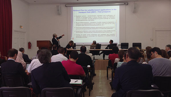
    MEDUSA sponsored a Think Tank May 19 in Tunis focused on EGNOS in Intelligent Transport Systems (ITS).

    Delegates from 10 countries met in Tunis May 19 for an “All-day-long Think Tank” organized by MEDUSA. The sixty participants represented Algeria, Belgium, Czech Republic, Egypt, Jordan, France, Italy, Morocco, Tunisia and Slovak Republic.

    Focused on the Intelligent Transport Systems (ITS) market, the event addressed the advantages of satellite navigation, and particularly of EGNOS and Galileo. ITS concerns the integration of information and communication technologies to create new applications and services for transport and mobility. ITS applies to all transport modes and is oriented to both passenger and freight transport. Satellite navigation plays an important role in ITS.

    The MEDUSA Think Tank opened with a keynote speech by Ammar Habib of the Ministry of Transport of Tunisia, who reaffirmed the country’s interest in the development of ITS and in the cooperation with Europe in relation to the exploitation of the services offered by the European GNSS in the various transport domains.

    The Euromed and European panelists gave a wide overview of existing and emerging applications in their countries, such as tracking and tracing of dangerous goods transportation, tracking special regulated fleets, emergency call, road tolling, urban traffic management, control of service fleets, and freight transit monitoring. They presented the existing technologies and value-added services that can be delivered through EGNOS today, and services that will become more robust thanks to Galileo in the future. It was recognized that the European GNSS, EGNOS and Galileo, can provide benefits to more than European countries and that, though primarily conceived for the aviation needs, EGNOS has interesting perspectives of utilization in ITS, and particularly in those applications requiring accurate and reliable positioning.

    The participants from different sectors (policy makers, users, technology and commercial players, experts) shared their experiences and lessons learned. They also had the opportunity for networking, establishing relationships, and strengthening cooperation on GNSS and ITS.

    Organized in combination with the Elgazala Innovation Days 2015, an international exhibition on information and communication technologies, the Think Tank is one of the technical assistance actions undertaken by MEDUSA and in the frame of the program of GEMCO (Galileo EuroMed Cooperation Office), the regional cooperation structure in Tunis set up and operated by MEDUSA.

    About MEDUSA —  MEDiterranean follow-Up for EGNOS Adoption

    Coordinated by Telespazio, the MEDUSA project belongs to the Euromed GNSS program, part of the Euromed Transport framework. MEDUSA aids the Euromed countries in the operational introduction and the exploitation of the European GNSS (EGNOS/Galileo) in various applications, mainly in the transport sectors. MEDUSA runs a program of technical assistance actions, aimed at capacity building, development of enablers and regional cooperation on EGNOS/Galileo.

  • FAA’s UAS Test Sites Receive Blanket Authorizations

    The nation’s six unmanned aircraft system test sites now have blanket authorizations to fly drones and no longer have to seek authorizations for each type of aircraft flown, according to new Federal Aviation Administration regulations.

    The new regulations streamline the approval process for UAS research by the test sites. They also allow those with only a recreational- or sport-pilot certificate to conduct test-site operations. Previously, the rules required operators to have a private pilot’s license. A third-class medical certificate also is no longer required. Now an operator only needs a valid driver’s license to satisfy the medical requirement.

    The FAA expects this improved access for the test sites will provide more opportunities for research that may help the agency integrate UAS into the nation’s airspace more quickly and easily.

    Under the new regulations, drones under 55 pounds operated by test sites may fly during the day up to 200 feet above ground level anywhere in the country, except in restricted airspace or near airports and heliports.

    The new Certificates of Waiver or Authorization (COAs) also let the test sites fly various types of UAS under a single COA, making it easier for them to conduct research missions. Previously, the FAA required authorization for each type of UAS the operators wanted to fly.

    Brian Wynne, president and CEO of the Association of Unmanned Vehicle Systems International (AUVSI), praised the FAA announcement. “This new policy will make it easier for the test sites to perform the research needed to safely integrate UAS into the national airspace system. It is an exciting time for the unmanned aircraft systems industry and policies like this help further advance UAS innovation.”

    When Wynne testified at the House Committee on Science, Space and Technology earlier in the year, he specifically called for a comprehensive industry-government UAS research plan, more resources for the federal government to coordinate UAS research and intellectual property protections for the companies that participate in UAS R&D.

    According to Wynne’s take on the new policy, things are heading in the right direction. “This new policy, the Center of Excellence designation and the Pathfinder Program announced earlier this month, along with ongoing industry and government research efforts, all point to a future where the possible will become reality,” he says.

    “Today’s FAA announcement is great news for the future of Nevada’s UAS Test Site effort,” says Tom Wilczek, aerospace and defense industry specialist for the Nevada Governor’s Office of Economic Development. “Nevada has been working diligently to get companies up and flying UAVs on our test sites, and the ability for us to implement public aircraft operations that fly under 200 feet … will significantly speed up the ability to test on our Nevada sites and move this emerging industry into commercial flights.”

    The expanded operational parameters for the test sites are similar to those the FAA implemented in March for civil UAS operations authorized under a Section 333 exemption.

    The six UAS test sites are the first public operators to receive this type of “blanket” airspace access across the United States, including Alaska and Hawaii. The sites may still fly outside the “blanket” COA parameters if they receive or retain separate COAs specific to the airspace requested for those operations.

  • Hyundai Launches Android Auto in New Car Models

    Hyundai Launches Android Auto in New Car Models

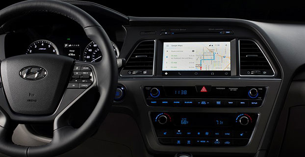
    Android Auto in the 2015 Hyundai Sonata. (Photo: Hyundai)
    Android Auto in the 2015 Hyundai Sonata. (Photo: Hyundai)

    Hyundai has become the first car company to launch Android Auto on production vehicles. Android Auto is premiering on the 2015 Sonata with Navigation at dealerships nationwide, and will later become available on other Hyundai models.

    “Android Auto aligns with Hyundai’s core interior design principles of safety, intuitiveness and simplicity,” said Dave Zuchowski, president and CEO, Hyundai Motor America. “We launched this highly anticipated feature on our best-selling Sonata, adding to our promise of value. With the launch of Android Auto, we provide more owners with the experience of cutting-edge technology.”

    Android Auto not only brings a high technology experience to Hyundai owners, but also improves safety, Hyundai said. For example, at any given daylight moment across America, approximately 660,000 drivers are using cell phones or manipulating electronic devices while driving, a number that has held steady since 2010. Android Auto helps keep drivers’ eyes and attention on the road by integrating the advanced driving-related functions of the user’s smartphone with the familiar centralized screen, physical controls and microphone of their car.

    Furthermore, the smartphone’s screen becomes “locked,” so drivers are not tempted to look down and interact with their phones directly while Android Auto is in use.

    Hyundai lists these advantages to Android Auto:

    • The Google Now card-based experience provides suggested locations and travel times based on the user’s searches, calendar entries and home and office locations, as well as weather information and “now playing” information for music streamed via the phone
    • App software (navigation, streaming music, etc.) is automatically updated because the apps live on the phone
    • Natural voice recognition with Google voice actions
    • Owners can easily bring their personal reminders, suggested destinations, calendar appointments and music preferences with them when they get in their car
    • Android Auto automatically pairs with the Sonata for phone calls through Bluetooth when connected for the first time via USB
    • Android Auto has familiar interfaces that are easy to use and have almost no learning curve.
    The Android Auto navigation screen.
    The Android Auto navigation screen.
  • SpaceX Falcon 9 Certified for GPS Launches

    SpaceX Falcon 9 Certified for GPS Launches

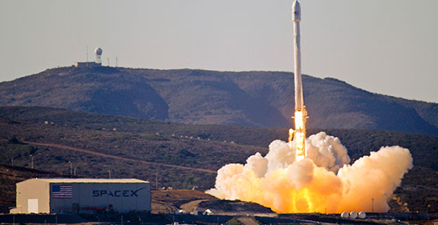
    Team Vandenberg launches its first SpaceX launch from Space Launch Complex-4 Sept. 29, 2013. 30th Space Wing's 1st Air and Space Test Squadron was the lead for all launch site certification activities at Vandenberg for SpaceX as an Evolved Expendable Launch Vehicle New Entrant. The squadron evaluated SpaceX's flight and ground systems, processes and procedures for the upgraded Falcon-9 rocket. (U.S. Air Force photo/Airman Yvonne Morales)
    Team Vandenberg launches its first SpaceX launch from Space Launch Complex-4 Sept. 29, 2013. 30th Space Wing’s 1st Air and Space Test Squadron was the lead for all launch site certification activities at Vandenberg for SpaceX as an EELV New Entrant. The squadron evaluated SpaceX’s flight and ground systems, processes and procedures for the upgraded Falcon-9 rocket. (U.S. Air Force photo/Airman Yvonne Morales)

    The U.S. Air Force has certified SpaceX’s Falcon 9 rocket to launch military satellites, clearing the way for SpaceX to bid on launches of GPS III satellites. The Air Force announced the decision May 26, which completed a nearly two-year process and establishes a competitor to United Launch Alliance.

    SpaceX, based in Hawthorne, Calif., is now eligible for award of qualified national security space launch missions as one of two currently certified launch providers. The first upcoming opportunity for SpaceX to compete to provide launch services is projected to be in June when the Air Force releases a Request for Proposal for GPS III launch services.

    “This is a very important milestone for the Air Force and the Department of Defense,” said Secretary of the Air Force Deborah Lee James. “SpaceX’s emergence as a viable commercial launch provider provides the opportunity to compete launch services for the first time in almost a decade. Ultimately, leveraging of the commercial space market drives down cost to the American taxpayer and improves our military’s resiliency.”

    This milestone is the culmination of a two-year effort on the part of the Air Force and SpaceX to execute the certification process and reintroduce competition into the Evolved Expendable Launch Vehicle (EELV) program. The Air Force invested more than $60 million and 150 people in the certification effort which encompassed 125 certification criteria, including more than 2,800 discrete tasks, three certification flight demonstrations, verifying 160 payload interface requirements, 21 major subsystem reviews and 700 audits in order to establish the technical baseline from which the Air Force will make future flight worthiness determinations for launch.

    “The SpaceX and SMC teams have worked hard to achieve certification, said Lieutenant General Samuel Greaves, commander of the Air Force Space and Missile Systems Center. “And we’re also maintaining our spaceflight worthiness process supporting the National Security Space missions. Our intent is to promote the viability of multiple EELV-class launch providers as soon as feasible.”

    “This is an important step toward bringing competition to National Security Space launch. We thank the Air Force for its confidence in us and look forward to serving it well,” said Elon Musk, SpaceX CEO and lead designer.

    The certification process provides a path for launch-service providers to demonstrate the capability to design, produce, qualify and deliver a new launch system and provide the mission assurance support required to deliver national security space satellites to orbit. This gives the Air Force confidence that the national security satellites being delivered to orbit will safely achieve the intended orbits with full mission capability.

    The SMC, located at Los Angeles Air Force Base, Calif., is the U.S. Air Force’s center for acquiring and developing military space systems. Its portfolio includes GPS, military satellite communications, defense meteorological satellites, space launch and range systems, satellite control networks, space based infrared systems and space situational awareness capabilities.

  • DeepOcean Hires Fugro for Fleet Positioning

    DeepOcean Hires Fugro for Fleet Positioning

    Credit: DeepOcean/Fugro
    Credit: DeepOcean/Fugro

    Fugro has been awarded a contract by subsea contractor DeepOcean for the provision of precise satellite positioning for its fleet.

    The contract is valid for three years and also includes the new vessels in DeepOcean’s expanding fleet. The DeepOcean fleet will be equipped with hardware and software developed by Fugro, providing independent positioning solutions on each vessel.

    Under the contract, Fugro will supply DeepOcean with three independent decimeter-level satellite navigation systems. Also part of the contract delivery are Fugro’s Starfix.G2+ system, which has a 3D accuracy approaching that of GNSS RTK systems, and Fugro’s Starfix.G4 satellite correction service.

    Starfix.G2 is a GPS and GLONASS positioning system based on orbit and clock corrections generated from Fugro’s own expanded network of dual system reference stations. Starfix.G2 is a precise point positioning (PPP) technology, which distinguishes itself from the traditional differential approach as satellite errors are not lumped together but estimated per source, per satellite. The GPS/GLONASS orbit and clock corrections are computed separately, free of ionospheric and tropospheric effects.

    Starfix.G4 is a GPS, GLONASS, Galileo and BeiDou positioning system based on orbit and clock corrections generated from Fugro’s network of reference stations. Like Starfix.G2, Starfix.G4 also uses PPP technology. The GPS/GLONASS/Galileo/BeiDou orbit and clock corrections are computed separately, free of ionospheric and tropospheric effects.

    DeepOcean is an integrated provider of services and technologies for the subsea industry, including offshore services for oil and gas, offshore renewables and electrical power transmission industries, with offices in Norway, UK, Holland, Brazil, Mexico and Singapore.


  • MachineryGuide Offers Smartphone Guidance for Agriculture

    MachineryGuide Offers Smartphone Guidance for Agriculture

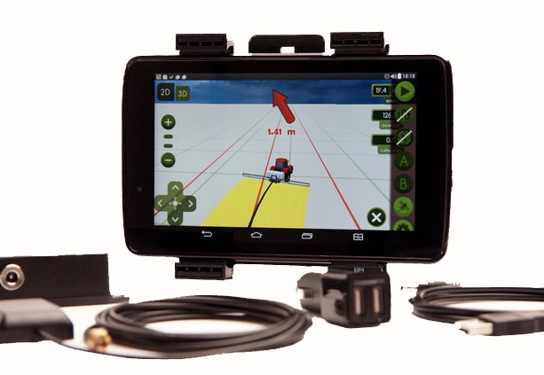
    The MachineryGuide package with antenna, receiver and guidance software.
    The MachineryGuide package with antenna, receiver and guidance software.

    MachineryGuide is a new GPS guidance system for Android that gives farmers the ability to use their smartphones for precision guidance.

    With the help of MachineryGuide, the cultivated area and overlaps can be displayed. The guidance application helps farmers in edging along the ideal track by gearing to straight reference lines.

    With the application and an antenna from MachineryGuide, farmers can have a simple precision guidance application to improve yield growth, increasing efficiency. Also, fertilizer and pesticide use can be optimized, while machine costs and work hours can be lowered by up to 10 percent, the app designers said.

    The application is aimed at managers of small- and medium-sized farms and can be used on a smartphone or tablet. A demo can be downloaded from GooglePlay — the free version can not connect to a real GPS device, but all the functions of the program can be tested.

    MachineryGuide sells the software separately; a GNSS receiver + antenna separately; and a package bundle that includes software, GNSS receiver and antenna. The antenna is capable of receiving and processing free corrections (EGNOS, WAAS).

    MachineryGuide has been listed among the top 5 farming apps according to Agrivi. Also, Croplife considers MachineryGuide one of the 10 best agricultural apps of 2015.

  • New Expectations Accompany Galileo Viability

    New Expectations Accompany Galileo Viability

    Alan Cameron
    Alan Cameron

    It is heartening to see a burgeoning constellation and its operators move on from doubt to certainty, as Galileo prepares for fuller operational capability and the expectations that scope elicits.

    To pick up the thread from last month’s column covering keynote speeches at the European Navigation Conference: plenaries subsequent to the opening session focused respectively on “GNSS for Aeronautical Applications: from GPS to Multi-Constellation with Galileo,” and “GNSS Resilience for Terrestrial & Naval Applications.”

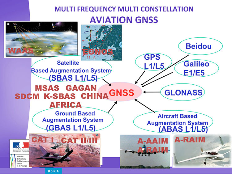
    Avionics. Benoit Roturier, GNSS and Performance-Based Navigation program head for the French air traffic control agency, Direction des Services de la Navigation Aérienne (DSNA), reviewed the rather complex assembly of air navigation systems gradually coming together. Not quite — or not nearly — a system of systems, as I understand it, more a conglomeration of systems.

    Slide from Benoit Roturier's presentation on behalf of the French air traffic control agency. (Courtesy of Benoit Roturier)
    Slide from Benoit Roturier’s presentation on behalf of the French air traffic control agency. (Courtesy of Benoit Roturier)

    Multi-constellation GNSS combos, with added context from satellite-based augmentation systems (SBAS), target provision of performance-based navigation (PBN) in all phases of flight, with increased robustness and availability, as well as escalating categories of precision approach and landing. Roturier presaged the SBAS message agreement that also took place in April with his observation that “[The] most benefits are achieved with two constellations — but which ones?” As four constellations and two frequencies deliver “many, many potential navigation modes,” how can air traffic controllers limit complexity while achieving maximum benefits? At the very least, there is a need to agree on main mode and reversion modes.

    He gave an overview of upgrades planned, in progress, and completed at airports around France. 141 runways are as of January 2015 equipped with PBN, with GNSS and often EGNOS approaches, compared with 260 still relying on older systems. He concluded with a summary of DSNA views, including “SBAS/EGNOS is seen as a free of charge, performing, mature and here to stay technology, supporting navigation and surveillance (ADS-B) performance requirements.”

    By the way, June’s EAGER enewsletter column will cover a recent EGNOS demonstration flight and the current state of runway approaches in Europe. Subscribe here for free.

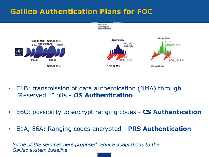
    GNSS Resilience. The second plenary, on resilience, brought forth some of the most pointed commentary of the conference. Ignacio Fernández Hernández of the European Commission spoke on Galileo differentiators for resilience: its authentication plans for the Open Service, Commercial Service, and Public Regulated Service, respectively. “The proposed GNSS authentication services are 100 percent backward compatible and interoperable with other receiver-based technologies.”

    Slide from presentation by Ignacio Fernández Hernández of the European Commission on Galileo differentiators for resilience. (Courtesy of the EC)
    Slide from presentation by Ignacio Fernández Hernández of the European Commission on Galileo differentiators for resilience. (Courtesy of the EC)

    Hernandez proferred the caveat that “some of the required changes to deliver these services (particularly OS authentication) are pending on an impact analysis by industry/ESA and are not yet in the baseline. We hope however to have them in the baseline soon and we’re working hard for it.”

    Matteo Paonni of the EC’s Joint Research Centre addressed spectrum management and regulatory issues, specifically the hot-button topic pseudolites. The EC is working closely with the United States and others to limit potential in-band interference risks. Outdoors, pseudolites are clearly undesirable; indoors, they offer some potential, but must be controlled.

    Paonni stressed that there is a clear need to protect GNSS spectrum, and that the EC and its member states are doing their utmost to install such protections, and are also promoting GNSS radio-frequency interference detection and mitigation initiatives. Galileo’s PRS is more robust and resilient, but it is not invulnerable.  GNSS vulnerabilities should be appreciated and backups put in place for critical systems; backups such as eLORAN, mini atomic clocks, GSM network, and so on.

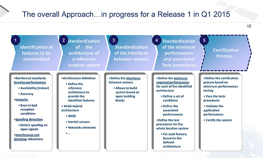
    Michel Monnerat of Thales Alenia Space focused on resilience in the road and LBS sectors. With a wide range of environments, devices and applications coming into play, “we need standardization” to specify levels of integrity and levels of performance for each different set of parameters. Thales Alenia is developing just such a set of performance requirements and references, with a first version set for release and discussion soon.

    Slide presented by Michel Monnerat of Thales Alenia Space, which is working on a standardization protocol proposal, to be released soon. (Courtesy of Thales Alenia Space)
    Slide presented by Michel Monnerat of Thales Alenia Space, which is working on a standardization protocol proposal, to be released soon. (Courtesy of Thales Alenia Space)

  • Airbus Defence and Space Joins ESA BIC Bavaria as New Partner

    Photo: Airbus GroupESA BIC Bavaria, part of the European Space Agency’s Business Incubation Centre (BIC) program, is poised to expand its presence in the aerospace hotbed Bavaria with the opening of another branch office in Ottobrunn near Munich. The Bavarian state government — itself a longstanding ESA BIC partner and supporter — also hailed the program’s new partnership with Airbus Defence and Space at the Ludwig Bölkow Campus in Ottobrunn.

    “The new ESA BIC Bavaria branch location in Ottobrunn will enable us to drive the creation of new start-ups based on the research endeavours pursued on-campus,” explained Ilse Aigner, Bavaria’s State Minister of Economics. “Smaller companies in particular have the ability to provide fresh, innovative ideas to Bavaria’s aerospace industry. Much of this sector’s supplier landscape also focuses on the midmarket, which makes these firms’ contributions all the more important.”

    Airbus Defence and Space and the ESA BIC program expect their combined efforts to achieve another surge in the commercial use of space infrastructures and technologies.

    “The aerospace hub of Ottobrunn and its newly constructed Ludwig Bölkow Campus offer an ideal setting for new companies to grow in collaboration with research and development. This new location promises to integrate Ottobrunn into the ESA BIC Bavaria’s outstanding partner program,” said Thomas Müller, member of the Executive Committee of Airbus Defence and Space and responsible for the Airbus site in Ottobrunn.

    “The Ludwig Bölkow Campus is proud to figure amongst ESA’s Business Incubation Centres from now on,” added Alexander Mager, managing director of the Ludwig Bölkow Campus GmbH.

    The ESA BIC program now offers start-up entrepreneurs extensive financial and technical support at 20 locations in eight countries: Belgium, France, Germany, Italy, the Netherlands, Portugal, Spain, and the UK.

    “ESA’s incubation program has already helped to found 300 companies and is now supporting 100 new start-ups every year, making it the fastest-growing initiative of its kind in the space industry,” said ESA Director General Jean-Jacques Dordain, “and I am glad that the first one created was here in Bavaria with the strong support of the government and of the DLR.”

    Anwendungszentrum GmbH Oberpfaffenhofen (AZO), which manages the ESA BIC Bavaria, has been responsible for 98 of these new foundations and the creation of more than 1,200 new jobs, which — along with its impressive network of partners — gives it a place of prominence among ESA’s incubation centers in Europe. Bavaria’s ESA BIC program works closely with the German Aerospace Center (DLR) and the Fraunhofer-Gesellschaft, Germany’s two largest research institutions. Further support is provided by the Wirtschaftsförderung Berchtesgadener Land (a local business-promotion association) and Bavaria’s two most financially sound savings banks, Sparkasse Nürnberg and Kreissparkasse München-Starnberg-Ebersberg.

    Start-ups founded through the ESA BIC program benefit from a broad portfolio of space technologies and IP protection services, as well as from their cooperation with the various partners involved, according to ESA BIC Bavaria. “Europe’s space programs in satellite navigation (Galileo), Earth observation (Copernicus), and satellite communications also offer fantastic opportunities to established companies — and especially to those just getting their feet on the ground,” ESA BIC Bavaria said in a statement.

    “Airbus Defence and Space is the first industrial aerospace company to join our incubation program,” said Thorsten Rudolph, CEO of AZO. “With its help, we’ll now be able to offer our incubatees and new companies an even wider range of support, from financing and R&D all the way to market launch.”

  • Federal Radionavigation Plan Touches on NDGPS, eLoran

    News courtesy of CANSPACE Listserv

    The 2014 Federal Radionavigation Plan, just released from the U.S. Department of Transportation, touches on funding for the Nationwide Differential GPS and the use of eLoran as a precision timing alternative.

    The plan is signed by the Secretaries of Defense, Transportation and Homeland Security, and released by the DOT Office of the Assistant Secretary for Research and Technology. A PDF of the document has been posted to the NAVCEN’s website.

    Nationwide Differential GPS (NDGPS). The nationwide differential GPS (NDGPS) service augments GPS by providing increased accuracy and integrity using land-based reference stations to transmit correction messages over radiobeacon frequencies. The service has been implemented through agreements among federal agencies including the Coast Guard, DOT and the Army Corps of Engineers, but a decision has not yet been made on funding beyond FY2016:

    “The Department of Homeland Security, in coordination with the Department of Transportation, is analyzing the future requirements for the NDGPS to support investment decisions beyond Fiscal Year (FY) 2016. Future investment decisions might include maintaining NDGPS as currently configured, decommissioning NDGPS as currently configured, or developing alternate uses for the NDGPS infrastructure. Contributing factors to these decisions are: (1) the U.S. Coast Guard change in policy to allow aids to navigation (ATON) to be positioned with a GPS receiver using Receiver Autonomous Integrity Monitoring (RAIM), and to allow USCG navigation in all waters using the WAAS receiver; (2) limited availability of consumer grade NDGPS receivers; (3) no USCG DGPS carriage requirement on any vessel within U.S. territorial waters; (4) the Presidential Directive turning off GPS SA; (5) continuing GPS modernization; and (6) the Federal Railroad Administration’s determination that neither NDGPS, nor High Accuracy NDGPS, are requirements for the successful implementation of Positive Train Control.”

    eLoran for Timing. eLoran is mentioned in the plan only briefly, in the following excerpt about precision timing alternatives:

    “For precise timing applications, chip-scale atomic clocks are now available from at least one company, and others have active research and development programs in the United States and abroad. The U.S. Coast Guard has established a Cooperative Research and Development Agreement to assess a high-power wireless alternative for providing precise time using U.S. government facilities such as mothballed Loran-C sites, upgraded to eLoran capability. If successful, this effort would offer another solution suitable for integration with GPS, or use as an independent complement to GPS, that could together provide highly available and precise timing for many applications.”