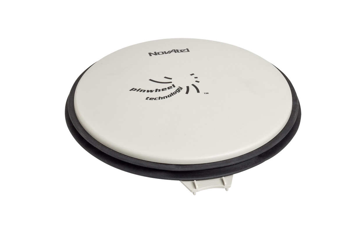
NovAtel Inc. has introduced the GPS-713 pinwheel antenna, available in two configurations: the standard GPS-713-GGG-N and the L-Band capable GPS-713-GGGL-N.
Both antennas provide enhanced Inmarsat interference rejection, allowing tracking of GNSS signals in the presence of high-powered Inmarsat transmitters typically found on marine vessels. The antennas receive GPS L1, L2, L5; GLONASS L1, L2, L3; BeiDou B1, B2; and Galileo E1, E5a/b frequencies, optimizing global satellite tracking capabilities. Customers can use either antenna for GPS-only or multi-constellation applications, providing excellent flexibility and reduced equipment costs, NovAtel said.
Designed for baselines of any length and easy installation, the phase center offset of these antennas remains constant as the azimuth and elevation angle of the satellites change. The antenna shares the same form factor as other NovAtel GPS-700 series antennas, and is enclosed in a durable, waterproof housing. Its compact, lightweight size makes it suitable for a wide variety of environments and applications.
JSC “Russian Space Systems” (RCC), together with ISS Reshetnev, plan to remove imported components in construction of GLONASS satellites, according to an Izvestia article.
Production of the advanced GLONASS satellite “GLONASS-K” is scheduled to begin later this year.
According JSC CEO Andrew Tyulina, the company intends to stop the use of foreign electronic components as soon as possible. The plan is to have 80 percent of the satellites’ electronic components payload be domestically produced by 2019.
The move seems to be spurred by international sanctions in response to Russia’s occupation of Ukraine. Following the occupation, the United States began to prohibit supply of electronic components to Russia, and the British company E2V failed to get permission to import equipment for the Russian space observatory Spektr-UV, Izvestia reports. Russia had difficulty securing components before then, however. In 2013, as relations with the U.S. cooled following Russia’s harboring of Edward Snowden and events in Syria, the U.S. State Department did not authorize a supply of components for the spacecraft Geo-IK-2.
The expected component supplier will be the largest designer and manufacturer of electronic components in Russia, Roselectronika, an entity that unites 112 companies, research institutes and design bureaus. The total investment in Roselectronika will exceed 210 billion rubles to 2020, including provision for modernizing industrial sites that produce electronic payloads for space.
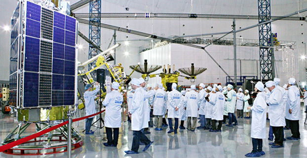
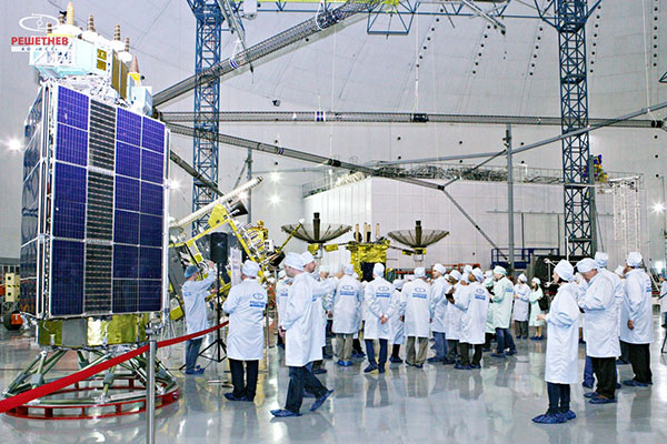
Seminar participants visit the GLONASS production facility. (Photo: Reshetnev)
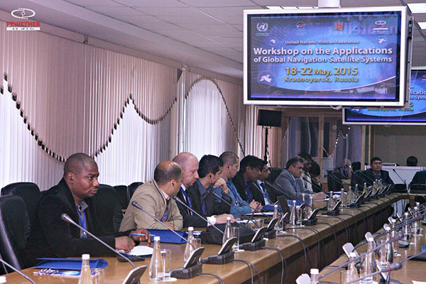
A United Nations workshop held in Krasnoyarsk, Russia, May 18-22 focused on sharing GNSS in various countries, as well as training in GNSS technologies.
The five-day workshop, organized jointly by the United Nations Office for Outer Space Affairs and the Russian Federal Space Agency (Roscosmos), sought to address the use of GNSS for various applications that can provide sustainable social and economic benefits, in particular for developing countries.
Titled “The use of global navigation satellite systems, GNSS/GLONASS,” the meeting was hosted by the Reshetnev Information Satellite Systems Joint Stock Company. This is the first time the workshop was held in Russia.
A key topic of discussion was the sharing of GNSS in different countries, according to the Reshetnev website. Particular attention was paid to training in the use of satellite navigation, with the most important outcome a proposal to create, under the auspices of the Reshetnev company, an international education center in the use of satellite navigation. The center will cooperate with the UN office in Vienna, as well as regional centers in Morocco, Nigeria, India, Brazil and China.
The seminar was held in nine sections. The sections considered topics such as the formation and development of GNSS, GNSS infrastructure, and national projects on the use of satellite navigation. Representatives from more than 20 countries in Asia, Africa, Europe, North and Latin America shared their experiences implementing GNSS services and spoke about the real and projected benefits of using these technologies for social and economic development.
During the seminar, participants visited the MFReshetnev satellite production company responsible for the space segment of GLONASS in Russia. Guests were shown current and future GLONASS-M and GLONASS-K satellites, as well as learned about the latest developments for GLONASS.
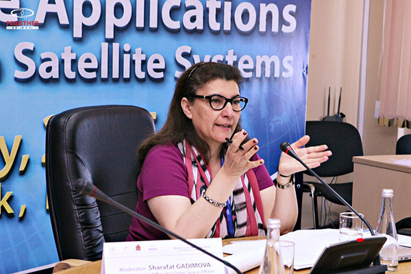
UN representative Sharafat Gadimova summarizes the workshop. (Photo: Reshetnev)Participants discuss the uses of satellite navigation. (Photo: Reshetnev)
Exelis, UrsaNav, the Department of Homeland Security’s Science and Technology Directorate (DHS S&T), and the U.S. Coast Guard have entered into a cooperative research and development agreement (CRADA) for testing and demonstration at former Loran-C sites.
The team will evaluate eLoran as a potential complementary system to GPS. The capabilities and potential utilization methods of eLoran will be explored in depth to identify all strengths, capacities, and potential vulnerabilities of the technology.
The sites are the legacy ground-based radio navigation infrastructure of the decommissioned Loran-C service that could be retained and upgraded to provide eLoran low frequency service.
Under the CRADA, Exelis will use the former Loran-C assets to put eLoran signals in space for research, test and demonstration of the ability of eLoran to meet precise positioning, navigation and timing (PNT) requirements of government and privately-owned critical infrastructure. The first station Exelis will broadcast from is located in Wildwood, N.J. The broadcast will provide a usable signal at a range up to 1,000 miles.
“eLoran is an ideal technology to complement GPS for critical, resilient and assured PNT,” said Ed Sayadian, vice president of Civil & Aerospace Systems for Exelis. “eLoran is a difficult to disrupt technology that offers PNT and wide area broadcast data capabilities indoors, in underground locations and other GPS-denied environments.”
“A preponderance of government, academic, and industry reports have concluded that eLoran is the best independent, multi-modal solution to provide assured PNT as a complement to GPS,” said Chuck Schue, president and CEO of UrsaNav.
Exelis and UrsaNav have entered into this CRADA because they believe that low frequency signals, such as eLORAN, operate independently of GPS signals and can provide alternative timing, either standalone, or as a component of a PNT service. Exelis also believes that as a result of its wealth of experience in its PNT portfolio, that there are many civil and defense applications that require precise time and/or position in GPS-denied environments. Examples include radio frequency interference, both intentional and unintentional; signal attenuation from heavy forest canopy, terrain or buildings; and indoor and underground locations.
Ship management company EuroShip Services Ltd. has installed eLoran as a backup to GPS to ensure the safety of its vessels operating off the coast of the United Kingdom.
The trial installation may lead to implementation across the full fleet of 16 vessels managed by Euroship, working routes in Northern Europe. The land-based radio navigation system is intended to seamlessly take over in the event of a GPS outage. EuroShip plans to simulate GPS outages to test eLoran provision of position, navigation and timing data automatically.
Euroship Services is one of the first ship managers to trial eLoran as a back-up to its GNSS. The company manages vessels owned by Cobelfret. They are mostly shortsea vessels, operating in and out of port, frequently in congested waters and with bridge teams that rely heavily on bridge systems for situational awareness.
Euroship managing director Frank Davies told Lloyd’s List that the company has so far been impressed with the first trial system on one of the company’s vessels. He said that with the company’s vessels entering and exiting large European ports, crews have even noticed distorted GPS signals while going under bridges.
Signals from both Galileo satellites launched March 27 are now transmitting signals.
Researchers at Université de Liège and at the German Aerospace Center (Deutsches Zentrum für Luft- und Raumfahrt, or DLR) reported on May 21 that the first of the full-operational-capability (FOC) satellites had begun transmitting standard L-band signals. The satellite, designated Galileo 8, is using pseudorandom-noise-code identifier 22.
The first E1 and E5 signals from Galileo 8 were received at an International GNSS Service Multi-GNSS Experiment tracking station in Windhoek, Namibia, at about 11:32 UTC on May 21. The satellite’s signals were subsequently tracked by a station in Wettzell, Germany, and then by others.
The other satellite, Galileo 7, began transmitting standard L-band signals on May 25. The first E1 and E5 signals from Galileo 7 were received around 17:00 UTC. The satellite is using PRN code 26.
The signals will be set unhealthy for use until satellite commissioning is completed.
Galileo 7 is also known as GSAT0203, FOC-FM3 and as NORAD object 40544. Galileo 8 is also designated GSAT0204, FOC-FM4 and NORAD object 40545.
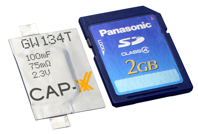
Cap-XX Thinline Supercapacitor shown with an SD card.
Cap-XX, developer of flat supercapacitors for burst and back-up power in space-constrained electronic devices, has launched its Thinline series of single-cell supercapacitors. The thin (0.6-mm) supercapacitors were developed to address the size, weight and cost challenges of designing thin, sometimes disposable electronic devices for the Internet of Things (IoT).
Examples include wearables (medical, fitness and health monitors, smartwatches, drug delivery systems), portables (active credit cards, smartphones, RFID tags), and connected electronics (smart homes and smart buildings, electronic shelf labels, wireless sensor networks).
To reduce thickness and manufacturing costs, CAP-XX increased the power and energy density in its electrode materials to deliver equivalent performance in about half the volume, and eliminated the folded edges and copper terminals that contribute to thickness in its standard line supercapacitors. (For comparison, CAP-XX’s thinnest traditional single-cell supercapacitor is 1.10 mm.)
Cap-XX Thinline supercapacitors support power requirements in IoT devices including GPS acquisition, wireless communication (Bluetooth, Bluetooth Smart, Zigbee, Z-Wave, Ant, active RFID), electronic paper and OLED displays, haptic or tactile feedback, vibration alerts, and injection or inhalation system delivery.
Cap-XX supercapacitors benefit from a nanotechnology construction that stores electrical charge in engineered carbon electrodes on aluminium foil, to minimize resistance and maximize capacitance. The electrode construction packs the highest energy and power densities possible into thin, prismatic packages, the company said.
Supercapacitors can handle peak power events, supporting batteries and energy harvesters configured to provide low-power current at maximum efficiency. This architecture allows designers to use smaller, cheaper, low-power batteries and extend their run-time and cycle life, or use intermittent ambient energy sources such as solar photovoltaic. Supercapacitors also enable ultra-quick device charging and wireless power transfer, and provide the backup needed for graceful shutdown and “last gasp” transmissions in mission-critical applications.
The Thinline idea was born while working with a customer designing a disposable insulin pump. “We figured out how to eliminate materials and change some processes to reduce costs and thickness,” explained Anthony Kongats, Cap-XX CEO.
Thinline works with thin-film, solid-state, and other low-power batteries such as coin cells/button cells, energy harvesting modules (solar, vibration/kinetic, RF, and other ambient energy sources), as well as inductive/wireless and cable/cradle fast-charging systems.
Features of Thinline include:
Extremely thin, flexible packaging from 0.6mm (600µm) thick
Best-in-class power density and power output (up to 117kW / litre)
Ultra-low resistance, even at low temperatures (ESR from 16mΩ, 2x nominal at -40°C)
Excellent energy storage to support ambient/intermittent sources (up to 0.8Wh / litre)
High cell voltages to facilitate integration with primary batteries (up to 2.75V continuous)
Wide operating temperature range (from -40°C to +85°C)
Very low leakage current to maximize battery life and minimize losses (typically < 1µA)
Virtually unlimited charge-discharge cycle life
Cap-XX Thinline supercapacitors are available in three footprints:
“A” series: 19.5mm x 20.0mm x 0.6 – 0.9mm thick, 60 – 180 mF, 45 – 200 mΩ
“W” series: 28.0mm x 20.2mm x 0.6 – 0.9mm thick, 100 – 300 mF, 24 – 120 mΩ
“S” series: 39.0mm x 20.2mm x 0.6 – 0.9mm thick, 180 – 540 mF, 16 – 75 mΩ
Suggested retail price for all 0.6-mm cells is less than US$1 in large volumes. The 0.7 mm and 0.9 mm cells in each series have higher C/lower ESR and cost slightly more. All parts are available in a 2.3V / 70°C, or 2.75V / 85°C configuration. They can be assembled by soldering or welding (ultrasonic, laser or spot).
Marketsandmarkets.com is offering a new report on the precision farming market, with forecasts to the year 2020. The report covers various technologies and components, including GNSS.
The report is titled “Precision Farming Market by Technology (GPS/GNSS, GIS, Remote Sensing & VRT), Components (Automation & Control, Sensors, FMS), Application (Yield Monitoring, VRA, Mapping, Soil Monitoring, Scouting) and Geography – Global Forecasts to 2020.”
According to marketsandmarkets.com, “Precision farming is growing rapidly from its infancy towards maturity. Driven by advancements in data management, precision farming has a remarkable impact on traditional approaches to farming. Applying technological developments in data collection and geo-location tracking, precision farming uses technology to optimize yield and detect operating efficiencies as well as deficiencies. Precision farming applications guide farmers about the right time to plant and harvest, and the amount of fertilizers and pesticides needed for better yield production. This information helps cut down input costs, fuel usage, and labor, and negate the environmental impact. Farmers across the globe have been benefitted due to innovations in precision agriculture.
“Major drivers for this market are augmented yield and profitability, which are contributing factors for farmers to opt for precision farming; other drivers like energy and cost saving, and government assistance have also been contributing to the market growth. Major restraints like high initial investments, and lack of awareness and their impact analysis are also covered under this study.
“The total precision farming market size is expected to grow at a CAGR of 12.2% from 2014 to 2020 and reach $4.55 billion by 2020. The report analyzes the precision farming supply chain, giving a very clear insight of all major segments and supported segments to the industry. The report also provides a detailed scrutiny of the Porter’s five force analysis for the market. All five major factors in these markets have been quantified using internal key parameters governing each of them.
“The report also includes company profiles of leading players in this industry with their recent developments and other strategic business activities. The competitive landscape section of the report entails key growth strategies and detailed market share analysis of key industry players. Some of the major players in the precision farming market are AgJunction Inc. (U.S.), Ag Leader Technology (U.S.), Dickey-John Corporation (U.S.), Teejet Technologies (U.S.), Deere & Company (U.S), Trimble Navigation System (U.S.), Precision Planting Inc. (U.S.), ACGO Corporation (U.S.), Topcon Precision Agriculture (U.S.), and Raven Industries Inc. (U.S.).”
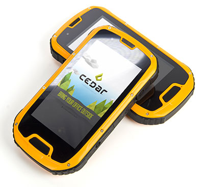
The CT4 and other rugged handhelds by Cedar Tree Technologies will now be available through Juniper Systems.
Juniper Systems is merging its subsidiary company, Cedar Tree Technologies, into Juniper Systems. The move will allow customers to purchase Cedar’s Android-operated rugged handhelds directly from Juniper Systems.
Juniper Systems launched Cedar Tree Technologies as a rugged handheld company in August 2014.
“With a reputation for top-of-the-line, ultra-rugged handheld computers, Juniper Systems aimed to expand its products to meet the needs of customers who may not need the outstanding level of ruggedness or support that Juniper handhelds provide. And that’s how Cedar Tree Technologies began. Cedar handhelds lie somewhere between consumer devices and Juniper Systems’ ultra-rugged handhelds, providing a mesh of both ruggedness and affordability,” said a statement from the company.
Cedar handhelds run on the Android operating system, offering access to thousands of business-ready apps and Google services via the Google Play Store. This provides users with an off-the-shelf product, eliminating the need to download third-party data collection software. Juniper Systems has published a blog post that outlines the differences between Cedar and Juniper handhelds.
The Cedar product line that Juniper Systems will now be carrying includes three new handheld devices:
CT7 Rugged Tablet. Featuring a large, 7-inch display, the CT7 tablet is IP67 waterproof and dustproof, and is priced at $899 USD.
CT4 Rugged Handheld. The CT4 handheld is a more compact device than the CT7. Featuring a 4.3-inch display and an IP68 waterproof and dustproof rating, it is priced at $489.
CMP1 Miniphone. The CMP1 Miniphone is rated IP65 (dustproof and resistant to water), and is ideal for swapping out a regular smartphone for outdoor excursions, for kids, or for use as an emergency phone. The CMP1 sells for $124.
Antenova announces its first antenna for consumer applications — the tiny Weii 2.4-GHz ceramic antenna. Measuring 1 mm x 0.5 mm x 0.5 mm, the company believes the Weii could be the smallest antenna in the world.
The new Weii miniature ceramic antenna is designed for 2.4-GHz, Bluetooth, Wi-Fi, Zigbee and industrial, scientific and medical (ISM) applications.
While all of Antenova’s antennas and antenna module products are small surface mounted devices, this antenna is the smallest that Antenova has created so far. It is designed specifically for the consumer, Internet of Things (IoT) and machine-to-machine (M2M) markets.
Colin Newman, Antenova’s director and vice president of sales, explains how Antenova has miniaturized the antenna. “Ceramic antennas offer low dielectric losses and high isolation. Our engineers have used this technology to greatly reduce the antenna volume without sacrificing performance. The challenge in building antennas for today’s small consumer devices is to achieve high isolation and frequency selectivity while maintaining good efficiency. This antenna is resistant to detuning from environmental effects, and combining this with its ultra-small size, makes it ideal for today’s wearable products.”
The Weii is an omni-directional, surface-mount device (SMD) mounted dielectric antenna that can be used to add wireless connectivity to any small electronic device, such as wearables, headsets, medical devices, personal navigation devices, dongles and sensors.
A ceramic antenna offers several advantages for these emerging applications. Its tiny footprint is designed for the new, scaled-down printed circuit boards (PCBs) that are being developed for consumer devices in M2M. It offers a highly efficient antenna that is powerful over indoor ranges, and that performs well when sited close to the human body, Antenova said.
Antenova says it takes a unique approach to the design of antennas, which it calls “Design For Integration” (DFI). Because the antennas are always embedded within a customer’s design, the successful operation of the customer’s device depends upon obtaining the correct performance from the antenna when it is placed on the PCB; therefore, Antenova is designing its antennas with this difficult RF integration in mind.
The Weii is designed to be easily integrated into all kinds of PCB designs and various ground plane sizes — it has been engineered so that it can simply be dropped into the design, using CAD footprint files, which are provided free of charge. To ensure that customers can harness the antenna successfully and achieve the optimal performance of the antenna, Antenova provides engineering assistance along with advice on RF design layout and the integration of the antenna, and customer support.
The antennas are available through distributors worldwide. See www.antenova-m2m.com for more details, or to request a sample board for the Weii antenna.
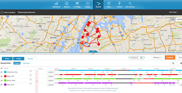
A new routing program from Fleetmatics Group is coming this summer. Fleetmatics Routist is an intelligent routing optimization solution that systematically builds the most cost-effective, customer-friendly routes for fleets.
Fleetmatics Routist seamlessly calculates and deploys route plans to drivers in the field, and features real-time and historical data that gives users the most holistic view into routing performance, the company said.
Fleetmatics Routist operates by taking locations, vehicles, time windows, technician skills, and costs and capacities into consideration, among other inputs, while remaining simple and intuitive for customers to use. Fleetmatics Routist also incorporates historical traffic data into its algorithm, elevating traffic and routing optimization effectiveness for customers operating in metropolitan areas.
“Inefficient routing wastes minutes, miles and money, leaving on-time arrivals and important elements of customer satisfaction to chance,” said Jill Ward, president and chief operating officer of Fleetmatics. “Customers that choose Fleetmatics Routist won’t have to worry about manual or time-consuming routing, and we fully expect the benefits will extend to their customers, as well.”
Fleetmatics Routist’s robust feature set, offered to customers as an add-on module, will integrate into the Fleetmatics REVEAL fleet management solution, helping it to become one of the most effective routing optimization solutions known to be available today. Customers can import work orders from electronic files or integration with their order management software, select the drivers involved in the plan, and get a cost efficient and customer satisfying route, Fleetmatics said.
Route planners can make adjustments to the plan based on their own business insight, and then deploy to the field. Route plans can be delivered effortlessly to drivers via the Fleetmatics REVEAL Field Application for smartphone and mobile devices, via Garmin integrated devices or simple route sheets printed at the office.
Once the routes are live, dispatchers and managers stay current on a driver’s progress against route stops in real-time on the Fleetmatics REVEAL live map and can make real-time adjustments as needed. When the day is done, actual versus plan analysis is available to compare the stops made by drivers against the work orders provided, so managers can provide appropriate coaching around route deviations and the impact of field activity on customer satisfaction.
Register here to receive additional information and notice of Fleetmatics Routist’s availability.
The coming leap second on June 30 sounds as scary as the (turns out not-so-scary) Y2K bug. But the world has experienced leap second issues before, and most affected industries are taking steps to prepare.
The world’s clocks will be adjusted by one second on June 30, when a leap second will be inserted into Coordinated Universal Time (UTC), the standard international time scale. In theory, all UTC clocks should insert a second labeled 23h 59m 60s (the leap second) following one labeled 23h 59m 59s UTC. This is equivalent to having all of the clocks in the world stop for one second at that time, as explained in May’s Expert Advice column.
A problem with some GPS receivers implementing the extra second caused the U.S. Civil GPS Service Interface Committee (CGSIC) to issue a notice in February. But GPS receivers aren’t the only thing that could be affected.
The Wall Street Journal is reporting that financial regulators and market participants are worried enough about the leap second that they’re planning for potential disruptions. The adjustment could present technical difficulties for traders and exchanges, as some computers might not be programmed to account for the adjustment, according to a Dow Jones report.
“These guys are agonizing over it,” Steve Allen, a programmer-analyst at the University of California’s Lick Observatory, told Dow Jones. “It is definitely a hassle.”
A U.S. Commodity Futures Trading Commission spokeswoman said that “For the most part, we’re not too worried,” told Dow Jones. “But of course as the regulator, we do need to ensure folks are ready.”
The last leap second occurred on June 30, 2012, and that leap second caused technical problems for websites and computing systems — including Reddit, Mozilla, Gawker, FourSquare, Yelp and LinkedIn.
Google had prepared ahead of time and was unaffected. Google gradually adds a couple of milliseconds to its servers’ clocks throughout the day when a leap second is to occur. According to a 2011 Google blog, “We modified our internal NTP servers to gradually add a couple of milliseconds to every update, varying over a time window before the moment when the leap second actually happens. This meant that when it became time to add an extra second at midnight, our clocks had already taken this into account, by skewing the time over the course of the day.”
But many web services didn’t follow Google’s lead in 2012 and experienced disruptions. Qantas‘ computer system went down for hours, forcing employees to check in passengers by hand. For background on the 2012 event, and a good explanation on the reason for a leap second, read “Time to Get in Sync” by Richard Langley, GPS World Innovation editor.
Amazon Web Services said it plans to “implement alternative solutions to avoid the ‘:60’ leap second. This means that AWS clocks will be slightly different from the standard civil time for a short period of time.”
In the U.S., stock exchanges such as the New York Stock Exchange and Nasdaq are working around the leap-second time (8 p.m. in the U.S.) by closing its after-hours trading a half-hour early, which is scheduled for 8 p.m.
The Hong Kong Observatory is advising stakeholders and operators in information technology, telecommunication, transport, and finance to review whether systems under their management can handle leap seconds properly, and if necessary, consider testing and adjusting their systems to ensure normal operation during and after the introduction of the leap second.
Time and frequency company EndRun Technologies is offering leap-second information on its website, and Cisco is offering its customers guidance on how to deal with it.
Racelogic, who make the LabSat simulator, will be recording the Leap Second as it happens and will then have the scenarios available for customers to replay. A variety of recordings will be taken: GPS, GLONASS, and BeiDou constellations will each be captured as a single channel, and also as a simultaneous triple-constellation recording. These will then be available to use with the LabSat.