EOS has partnered with four high-resolution imagery providers — Airbus Defense and Space, SI Imaging Services, SpaceWill and 21AT — so users can purchase the latest images directly from LandViewer, the official high-resolution data reseller, or view the images of an area of interest in high resolution on the map.
LandViewer collects the latest up-to-date satellite imagery from commercial satellite providers and incorporates it into an easy-to-use platform. The collection is constantly being improved with new sensors.
LandViewer offers two data sources of commercial imagery:
High-resolution imagery (for analytics), to find and purchase high-resolution images for further in-depth analysis. In this case, the price is based on the size of the area of intersection between the selected image and your area of interest (AOI).
Image from Landviewer for analytics. (Image: EOS)
High-resolution imagery (view only) to view high-resolution images for your area of interest (AOI). In this case, the price is based on the number of tiles within your AOI. The view only option is designed as a stand-alone data source for the everyday business user.
Image from Landviewer (view only). (Image: EOS)
The EOS platform uses commercial imagery from LandViewer with a resolution between 0.3 meter and 1.5 meters, enabling a close look at assets of interest, anywhere in the world.
Pointfuse has released the latest version of its advanced point cloud processing software that converts the millions of individual measurements captured by laser scanning and photogrammetry.
Featuring new streamlined classification to ensure maximum efficiency and multicore processing for unlimited conversion power, the new version of Pointfuse is set to transform workflows within digital construction, facilities management and virtual design applications.
“Pointfuse is designed to make the use of point cloud data more accessible by removing many of the traditional barriers to use,” said Mark Senior, regional sales director at Pointfuse. “Obstacles such as processing time and computer power, incompatibility within existing workflows and outputs files that are large and complex; these have all been obliterated with the latest Pointfuse release.”
Pointfuse now includes a new streamlined workflow which makes object classification easy, using templates and shortcuts to ensure maximum efficiency. This ability to classify objects within Pointfuse has had a huge impact on how as-built data is utilized within digital design workflows; being able to quickly compare specific as-built objects with the design enables more accurate clash detection, reducing the number of false clashes being flagged.
IFC (Industry Foundation Classes — an open format data model that is intended to describe architectural, building and construction industry data) templates can also be created and edited for specific applications. With applications including architectural, MEP and HVAC, selected objects can be classified and mapped to ensure compatibility with onward workflows.
Pointfuse also includes a new conversion engine which uses multicore processing to manage and enable unlimited point cloud conversion to provide real scalability. In addition, Pointfuse’s mesh models are intelligently optimized, reducing the working data size by a factor of up to 100, making them easy to share with online 3D collaboration platforms, such as BIM 360, 3D Repo, Revitzo and Trimble Connect.
“Using Pointfuse we can create intelligent 3D mesh models in a fraction of the time,” commented Ben Callan, BIM coordinator in global construction services company ISG’s UK Fit Out business. “This accelerated modelling and reduced risk of error contributes to a direct reduction in costs when compared against traditional methods of modelling and point cloud data analysis. The easy to use, easy to consume outputs are also paving the way for new applications of the data including existing versus design clash avoidance and checks of temporary works against required construction activities.”
The estimated number of Galileo-enabled smartphones in use has reached one billion. This significant milestone has been achieved in the week when the European GNSS Agency (GSA), responsible for operation of the Galileo programme, celebrates its 15th anniversary.
The company BQ pioneered Galileo use in smartphones with its Aquaris X5 Plus in July 2016. Since then, market uptake of Galileo-enabled smartphones has been rapid as other manufacturers were quick to embrace the opportunities that Galileo offers.
Global annual GNSS receiver shipments are forecast to grow from 1.8 billion units in 2019 to 2.7 billion units in 2029.
Currently, 156 Galileo-enabled smartphone models available on the market. The “1 billion users” milestone is based on the number of smartphones using Galileo sold across the world. The actual number of Galileo users around the world is much larger. You can track which devices, including smartphones, are Galileo-enabled on the UseGalileo.eu site.
Today, 95% of companies that produce smartphone chips for satellite navigation make chips that enable Galileo. According to figures in the latest GSA GNSS Market Report, which is to be published soon, global annual GNSS receiver shipments are forecast to grow continuously across the next decade, from 1.8 billion units in 2019 to 2.7 billion units in 2029. Most of these shipments are for receivers costing less than €5, and 90% of receivers in this price segment are used in smartphones and wearables.
The number of Galileo-enabled smartphones in use has soared to 1 billion in just 3 years. (Image: GSA)
“Galileo is now providing high quality timing and navigation services to 1 billion smartphone users globally,” said Elżbieta Bieńkowska, commissioner for Internal Market, Industry, Entrepreneurship and SMEs. “This has been made possible by a truly European effort to build the most accurate navigation system in the world, with the support and dedication of the GSA. I am confident that our space industry will continue to thrive with more work, ideas and investment under the new EU Space Programme.”
“One billion smartphone users is a significant milestone and a major achievement for the Galileo programme and for the GSA,” said GSA Executive Director Carlo des Dorides. “The GSA has worked tirelessly to build bridges with research and industry and create a strong community of service providers who trust Galileo and understand the technological innovation opportunities it brings.
“Chipset and receiver manufacturers in particular have been quick to leverage Galileo’s outstanding performance,” des Dorides said. “These manufacturers believed in Galileo from the beginning, when Galileo was still an idea, and invested in the technology. It is thanks to them and the unique blend of expertise and knowledge of the GSA team that we are now celebrating 1 billion Galileo-enabled smartphones.”
To explore new investment support for the European space-based economy, the EIB and GSA are bringing together their expertise and experience. The common objective is to create high-skill jobs in the EU and improve the day-to-day lives of Europeans by supporting innovative companies and accelerating the development of new applications that use European global navigation satellite systems and earth observation data. These applications could be used to ensure smooth navigation, such as in search-and-rescue operations to save lives, for observing crops, and in precision farming to reduce the need for fertilizers and pesticides.
“Space is the final frontier, and there is a new worldwide ambition in reaching it. The EU’s global competitors and new private actors are investing heavily in the space sector. At the same time, new disruptive technologies and business models are emerging and changing the playing field,” said EIB Vice-President Ambroise Fayolle, who is responsible for innovation. “We need to make sure that Europe stays in the game. That is why we are particularly enthusiastic about this agreement with GSA. It is an important step to develop further support for European space entrepreneurs and businesses to eventually give them and the EU a competitive edge in this new space race.”
“Our expertise in market intelligence for satellite navigation and in supporting new business opportunities — thanks to EGNOS and Galileo — is the basis of our agreement with the EIB,” said Carlo des Dorides, GSA Executive Director. “We are confident that our cooperation will bring the extra added value required by entrepreneurs to transform their application businesses into globally successful companies.”
A changing space sector
The global space economy has been evolving rapidly in recent years. On average it has grown by 6.7% per year over the last 10 years, which is almost twice the 3.5% average yearly growth of the global economy. This growth has been partially driven by the US, China and other countries that have developed new ambitious space missions.
The main driver, however, has been the “New Space” phenomenon: a number of technological and business model innovations that have introduced new products and services and reduced the cost of accessing and using space.
The transformation of the space economy has seen new space companies investing over EUR 14.8 billion since 2000, with a fast accelerating trend: total investment in space companies grew by a factor of 3.5 in 2012–2017 compared with the previous six-year period. Moreover, US-based investors dominate the field accounting for around two thirds of the 400+ worldwide investors in space companies.
Historically, Europe has always been at the forefront of publicly-funded space exploration, investing massively in space infrastructures such as the Copernicus and Galileo satellite programmes. Europe still boasts academic and scientific excellence but risks missing the next wave of space innovation unless it seizes the opportunity to stimulate more private investment in the new space sector.
According to a recent EIB and European Commission study on the future of the European space sector, European space entrepreneurs feel there is a lack of private financing sources, particularly for late-stage investments. They therefore tend to keep an eye on private capital outside the EU, especially in the US.
In this context, European public innovation instruments play an essential role in unlocking private capital for the space sector. 40% of the European companies surveyed seek public funding, which serves as a seal of approval in the market, as a precondition for further private investment.
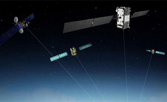
The Swift/Arm partnership means Arm will offer Swift Navigation’s high-integrity, high-accuracy GNSS positioning solutions as an option on Arm-based platforms to developers of autonomous and connected vehicles. (Image: Swift Navigation)
Swift Navigation is partnering with Arm, a global leader in semiconductor IP.
The partnership means Arm will offer Swift Navigation’s high-integrity, high-accuracy GNSS positioning solutions as an option on Arm-based platforms to developers of autonomous and connected vehicles.
Swift Navigation is a San Francisco-based tech firm redefining GNSS positioning technology for autonomous vehicles.
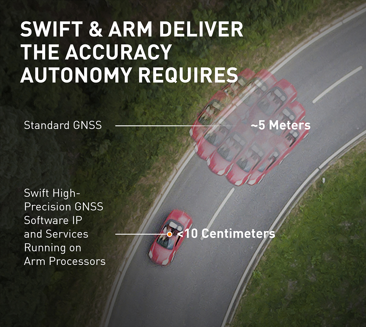
Standard GNSS positioning is three to five meters in depth which is not suitable for safety-critical systems requiring lane-level accuracy. For higher levels of autonomous capability, a vehicle needs to be able to determine its absolute location. To achieve this, high-precision localization is needed to get to accuracy down to the centimeter.
Swift’s partnership with Arm will deliver a high-integrity, high-accuracy GNSS positioning solution for silicon makers and Tier 1 and 2 auto suppliers to integrate precise positioning into the sensor suite.
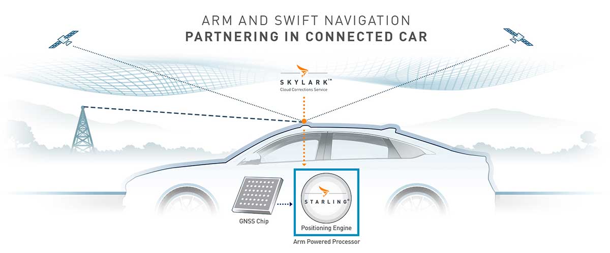
Swift Navigation’s Starling is a GNSS positioning engine designed for just such automotive and autonomous vehicle applications. Starling’s software enhances the measurements for commercially available GNSS receivers to provide true precision and integrity capabilities. Starling is receiver-agnostic, so it is ideal for Arm customers as it works with a variety of automotive grade chipsets and inertial sensors.
Swift’s partnership with Arm will deliver a high-integrity, high-accuracy GNSS positioning solution for silicon makers and Tier 1 and 2 auto suppliers to integrate precise positioning into the sensor suite. (Image: Swift Navigation)
Swift and Arm are working together to provide developers of autonomous and connected vehicles a cost-effective, scalable and high-integrity positioning solution. Starling is designed to be compatible with industry leading silicon makers who build their solutions on Arm.
Starling works with a variety of GNSS measurements engines and is a hardware proven, end-to-end solution, tunable for the specific requirements of a customer’s platform. This partnership elevates the capabilities of the connected car and simplifies the integration of high-precision GNSS into Tier 1 and 2, Silicon and Platform and Automotive OEM vendors.
“We are pleased to join the ecosystem of Arm technology partners to deliver precise positioning solutions to its automotive and autonomous vehicle customers,” said Timothy Harris, chief executive officer of Swift Navigation. “This partnership opens up a broader audience of customers who can benefit from Swift’s positioning technology and builds on our mission to enable a future of autonomous vehicles.”
“As we strive toward an autonomous future, the requirements of the automotive market are changing, and a more solution-based approach is needed,” said Dipti Vachani, senior vice president and general Manager, automotive and IoT line of business, Arm. “The combination of Arm IP uniquely designed for automotive and Swift’s GNSS solution gives our partners another key component on the road to the effective deployment of autonomous vehicles at scale.”
Available for purchase today for Arm-based processors, the Starling positioning engine provides a rapid deployment, low total cost of ownership solution to enable widespread adoption of ADAS, connected car, C-V2X and autonomous solutions.
Interested parties should visit this website to get more information on using the Starling positioning engine on Arm-based devices.
The joint solution will be also be showcased at the IAA New Mobility World 2019 event from Sept. 10-15 at the Arm booth, Hall 5.0, stand A10, Frankfurt Messegelände.
Japan-based Terra Drone’s newest branch, Terra Drone Australia, will focus on the mining, oil and gas, power and forestry sectors.
Terra Drone Corporation, an industrial drone services provider headquartered in Tokyo, has finalized its expansion into the Australian market after completing an equity investment in Australian firm C4D Intel Pty Ltd. As part of the deal, C4D Intel will immediately rebrand to Terra Drone Australia.
The move by Terra Drone is the latest of the company’s investments into drone technology businesses across the globe and demonstrates the Japanese company’s commitment to the Australian market. The terms of the transaction were not disclosed.
Founded in 2016, C4D Intel provides surveying, inspection and 3D modeling services to a diverse client base across mining, oil and gas, power and forestry industries in Western Australia.
The company specializes in large-scale unmanned aerial surveys, confined space infrastructure inspections, high-altitude inspections, bridge and pipeline inspections, and asset 3D modeling.
As Terra Drone Australia, the company will be able to leverage the additional growth capital to expand its service offering to include unmanned airborne lidar, bring innovative Terra Group technologies to Australia, and expand its operations to the East coast of Australia, Terra Drone stated in a press release.
The Australian drone service provider’s existing clients include mining companies Rio Tinto and Fortescue Metals Group, and large utilities such as ATCO Gas Australia and Synergy.
“We are delighted to join the No.1 industrial drone services company in the world, Terra Drone. When the world’s fastest-growing drone business chooses to expand to Australia, and selects our business to invest in, it speaks volumes about the opportunities available here and the vision we have for the company,” C4D Intel Operations Manager Will Wishart said.
“There are many advantages of being a part of a global organization and this next phase of growth makes for very exciting times. We have already leveraged Terra Drone’s international network to bring new technology to Australia and look forward to accelerating this as we expand our operations across the Australian continent.”
Terra Drone Corporation CEO Toru Tokushige added, “The establishment of Terra Drone Australia is another milestone for our international expansion strategy. Australia bears a strategic significance in our growth plans. Having a local presence in the region allows us to be close to our customers and strengthen our support to them.”
Later this month, Terra Drone Australia will bring innovative drone technology from The Netherlands to Australia for proof-of-concept trials for global mining company Rio Tinto. The Terra UT Drone from Terra Inspectioneering will allow Terra Drone Australia to offer ultrasonic thickness testing of steel in hard to reach places, such as bin walls which are subject to wear.
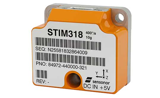
The new high-accuracy tactical-grade STIM318 inertial measurement unit (IMU) from Sensonor provides greatly increased accelerometer performance to support demanding guidance and navigation applications, the company said. Its performance can in many applications competitively replace fiber-optic gyros (FOGs).
Offering improved system performance with respect to robustness, reliability, size, weight, power and cost, it is designed for use in autonomous machine control, UAV payloads, satellites, portable target acquisition systems, land navigations systems, turret stabilization, missile stability and navigation, and mortar aiming systems.
STIM318 is comprised of three highly accurate MEMS gyros, three high-stability accelerometers and three inclinometers. Its development took place in close cooperation with a global customer developing autonomous machine control for accurate contour guidance. The IMU is built on the established STIM design that is field proven in commercial and military applications.
An ITAR-free product, STIM318 is available in export controlled and non-export controlled versions. It is compatible with Sensonor’s STIM300 IMU, and can bring additional capability to applications already using STIM300. STIM318 is available from stock.
In addition to the performance increase, STIM318 comes with a new Bias Trim Offset (BTO) function. This allows the user to individually zero out any bias of all 9 axes. The bias offset can be stored in flash, and then recalled at next system startup.
U.S. Space Command Commander General John W. “Jay” Raymond, in his first official directives, established two subordinate commands that will jointly provide support to the new Unified Combatant Command.
Combined Force Space Component Command and Joint Task Force Space Defense will focus the planning and execution of global space operations, activities and missions into two areas:
protection and defense from threats to U.S. space capabilities/forces and
maintaining and growing our national security space programs, combat-relevant space capabilities, and space cadre talent to increase warfighter lethality.
“To ensure USSPACECOM can conduct its mission decisively, I am establishing two subordinate commands with distinct and defined mission areas to ensure the command is postured to protect and defend, while also increasing joint warfighter lethality and strengthening partnerships,” Raymond said.
“The establishment of the Department of Defense’s 11th COCOM dedicated to space operations reflects the value of space contributions to national security, the evolution of the threats to U.S. space systems, and the importance of deterring potential adversaries from challenging or attacking U.S. space systems. These subordinate commands will have a direct impact on that mission,” he said.
JTF-SD
The JTF-SD will be commanded by Brigadier General Thomas L. James, with a mission to conduct space superiority operations in unified action with mission partners to deter aggression, defend space capability and, when directed, defeat adversaries throughout the continuum of conflict.
The JTF-SD will execute its protect and defend mission through various operations centers, including National Space Defense Center at Schriever Air Force Base, Colorado; Space Situational Awareness Units; and Emerging Space Defense Units.
CFSCC
Maj. Gen. Stephen N. Whiting. (Photo: USAF)
The CFSCC will be commanded by Major General Stephen Whiting with a mission to plan, integrate, conduct and assess global space operations in order to deliver combat-relevant space capabilities to Combatant Commanders, Coalition partners, the Joint Force, and the Nation. CFSCC plans and executes space operations through four distinct and geographically dispersed operations centers, including:
Combined Space Operations Center at Vandenberg AFB, California;
Missile Warning Center at Cheyenne Mountain Air Force Station, Colorado;
Joint Overhead Persistent Infrared Center at Buckley AFB, Colorado; and
Joint Navigation Warfare Center located at Kirtland AFB, New Mexico.
Additionally, CFSCC executes tactical control over a number of Air Force, Army and Navy space units.
Protecting critical space assets
“Over the past decade, our great power competitors have developed technologies that threaten our critical national assets in space,” Raymond said. “The U.S. has no desire to see a conflict in space, and we are working hard to ensure no country believes they can gain a terrestrial advantage by extending a conflict to space.
“It’s important to understand that, like all nations, we have the inherent right of self-defense, so purposeful interference with space assets vital to our national security will be met by leveraging our multi-domain capabilities across air, land, sea, cyber and space, and all of our instruments of national power.”
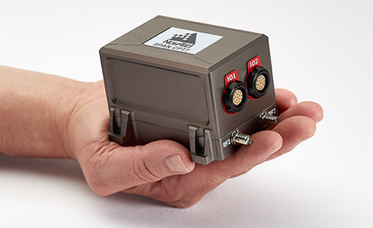
NovAtel, part of Hexagon’s Positioning Intelligence division, now brings users greatly improved processing speed and accuracy as well as significantly reduced signal acquisition time through the latest 7.07.03 firmware release.
The SPAN CPT7. (Photo: NovAtel)
The firmware works best with the recently launched TerraStar-X correction service, which delivers accuracy and reliability, as well as the OEM7, SPAN CPT7 and PwrPak7 products, which use signals from all GNSS constellations and frequencies to provide users with reliable autonomy and exceptional positioning availability.
The 7.07.03 firmware offers a significant improvement to the SPAN GNSS + INS (inertial navigation system) technology. SPAN with 7.07.03 shows improvements of up to 20% in the horizontal position over the entire SPAN IMU catalog and across various industry use cases including agriculture and marine. SPAN with 7.07.03 also provides improved motion detection, resulting in more robust time to convergence.
“The 7.07.03 firmware features improvements to both our SPAN Marine and SPAN Rail profiles that will greatly impact application performance and consistency,” noted NovAtel Director of Product Management, Neil Gerein, “The SPAN Marine Profile sees improvements to the heave performance and will allow users to start their work significantly faster thanks to a simplified setup for applications in marine dynamics. The SPAN Rail Profile improves position accuracy over long GNSS outages, which is crucial for applications in rail environments that often deal with potential signal obstructions such as trees, tunnels and dense urban areas.”
To download the 7.07.03 firmware update for your platform, click here.
3D modeling solution creates true-to-life synthetic environments for more accurate testing.
Spirent Communications plc has launched an innovative multipath simulation solution, Spirent Sim3D. The 3D modeling solution enables the testing of realistic multipath and obscuration effects on GNSS signals in a true-to-life synthetic environment.
Sim3D is suitable for use by automotive, chipset, handset and receiver manufacturers, as well as in aerospace, military, mining and precision agricultural applications.
Spirent will demonstrate Sim3D at ION GNSS+ 2019 in Miami, Florida, Sept. 16-20.
Studying multipath. Historically, researchers and developers of GNSS receivers have had to rely on statistical models and time-consuming field testing to study the effects of multipath on GNSS signals.
With Sim3D, the industry can now gain a greater understanding of the impact of multipath and obscuration in a broad range of real-life situations. It offers the level of control and traceability needed for developers to improve their customers’ experience in the most challenging environments.
A satellite signal reflecting off surfaces, such as a building, a high-sided vehicle, a tree, or even the ground, alters the pseudorange, causing the signal to arrive at the receiver slightly later than line-of-sight signals.
Without proper mitigation, this can cause a receiver to output an inaccurate position.
“Obscuration and multipath effects are one of the major obstacles faced by engineers trying to achieve accurate GNSS positioning solutions,” said Spirent Managing Director of Positioning Martin Foulger. “The accelerating development of connected autonomous vehicles and other precision applications means the need to test for higher precision positioning, navigation and timing in a variety of environments is growing rapidly. Sim3D is an important and timely development.”
Image: Spirent
Simulation of 3D environments. The unique system has been developed in partnership with OKTAL Synthetic Environment. It offers the ability to simulate multipath effects in a range of lifelike geo-typical environments, using different models to recreate locations such as urban highway, an inner city or a forest. Geo-specific models of real locations can also be commissioned.
During simulation with Sim3D, the GNSS signals interact with fully customizable 3D environments to simulate real-life applications in operation, like a vehicle on a highway, or a wearable device on a pedestrian.
This gives a level of detail, control and realism in testing not previously available. Such realistic multipath and obscuration simulation will add greater credibility to GNSS testing and assure that developed solutions are optimized and tested for their intended environments.
“As vehicles become increasingly autonomous, it’s vital to get a more detailed understanding of the effects of obscuration and multipath on a vehicle’s ability to generate an accurate GNSS-based position” explained Foulger. “Statistical models cannot sufficiently achieve this.
“Sim3D’s ability to realistically simulate different environments provides this greater accuracy and brings a host of benefits to researchers and developers of autonomous vehicle systems,” Foulger said. “It will help to guide critical design decisions like where to place the GNSS antenna on the vehicle, what GNSS receiver to use and when to hand over to other position sensors as GNSS signals degrade.”
GPS OCX will maneuver satellite into final orbit over 10 days
The U.S. Air Force used Raytheon Company’s GPS Next-Generation Operational Control System, known as GPS OCX, to support the launch of its second GPS III satellite into space. The ground system will now spend 10 days maneuvering the satellite into its final orbit, demonstrating GPS OCX’s ability to simultaneously support multiple GPS III spacecraft on-orbit throughout the checkout and calibration process.
Raytheon’s GPS OCX has obtained the highest level of cybersecurity protections of any Department of Defense space system.
“GPS OCX performed extremely well during the first launch and has exceeded performance requirements in the months since,” said Dave Wajsgras, president of Raytheon Intelligence, Information and Services. “The team was well-prepared for this launch, and we’re confident the system’s performance will continue to be positive.”
GPS OCX, the enhanced ground control segment of America’s GPS system, has achieved the highest level of cybersecurity protections of any Department of Defense space system. Its open architecture design allows it to integrate advanced protections as they become available, and the system’s industry-leading cyber protections are why it will be used to support all future GPS III launches and GPS constellation operations upon operational acceptance.
Earlier this year, the team completed final qualification testing of the system’s modernized monitor station receivers, which can receive and decrypt all GPS III military and civil signals. Global installation of the receivers starts next month and keeps the program on track for full system delivery by the program’s June 2021 contractual deadline.
In addition to GPS OCX’s role, RGNext, a joint venture between Raytheon and General Dynamics Information Technology, provided operational launch support to ensure the safe launch of the United Launch Alliance’s Delta-IV rocket that was carrying the GPS III satellite. RGNext operates the launch range on behalf of the U.S. Air Force, providing maintenance, range safety, weather monitoring, communication and surveillance support for all launches conducted by defense, civil and commercial companies at the range. To access our press kit, which includes photos, videos and an animation, please visit us here. To learn more about the program’s progress and additional capabilities, visit us here.
Teledyne Optech’s new compact lidar sensor, the CL-90, is available for purchase through its first integration partnership with Lidar USA.
For more than 20 years, Lidar USA has been building UAV sensor systems and has sold thousands of systems worldwide. Its ability to support numerous industries with cutting-edge integration makes them an ideal partner for Teledyne Optech’s compact lidar sensors, Teledyne stated in a press release.
Lidar USA’s products are used for surveying-related tasks ranging from topography work, to highways and land development. They are also used for agricultural work for forestry and plant growth, and have applications in archeology as well.
Teledyne Optech’s CL-90 sensor features exceptional canopy penetration for excellent ground coverage, higher downward point density for superior results in corridor/power line projects, long-range performance for maximum productivity at UAS ceilings and best-in-class data precision for tight-tolerance applications, the company said.
“Our customers face many challenging projects and they need tools that can deliver,” said Lidar USA CEO Jeff Fagerman. “Whether it’s greater range, more accuracy or better penetration of vegetation, using the new Optech CL-90 gives us the means of providing the tool to get the job done.”
Teledyne Optech Executive Vice President and General Manager Michel Stanier believes the partnership will help expand both companies’ global presence.
“Teledyne Optech is pleased to partner with Lidar USA to bring our compact lidar sensors to market,” Stanier said. “Lidar USA is a premier UAV solution provider. As a result, we are confident that their integration expertise and strong global market presence will provide the ideal platform to deploy the CL-90’s rich, unique feature set into the UAV marketplace.”
Lidar USA will be at Intergeo this year and can be found at ICS Foyer Stand 2 featuring a fully integrated CL-90 solution. Teledyne Optech will be featuring some of its new Compact Lidar suite of products this year at Intergeo Booth B3. 042 from September 17-19 in Stuttgart, Germany.