Author: GPS World Staff

  • Expert Advice: A Leap Second — One More Time!

    Expert Advice: A Leap Second — One More Time!

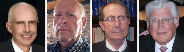
    From left: Dennis McCarthy, Wayne Hanson, Ronald Beard and William Klepczynski
    From left: Dennis McCarthy, Wayne Hanson, Ronald Beard and William Klepczynski

    By Dennis McCarthy, Wayne Hanson, Ronald Beard and William Klepczynski

    Once again we are going to adjust the world’s clocks by one second. This time it will happen on June 30, when we insert another leap second in Coordinated Universal Time (UTC), the standard international time scale. In theory, all UTC clocks should insert a second labeled 23h 59m 60s (the leap second) following one labeled 23h 59m 59s UTC. This is equivalent to having all of the clocks in the world stop for one second at that time.

    Are you ready for it?

    The last leap second occurred two years ago on June 30, 2012, and the continuation of the process of making these one-second adjustments has stirred a growing controversy over the last few years.

    How did the leap second come about — and why do we continue making these sporadic adjustments?

    From Sun to Caesium

    Historically, it has been easy to make use of the apparently uniform repetition of various astronomical phenomena to measure the passage of time. We’re familiar with the Sun rising and setting, and this regularity provides us a convenient measure of time: the solar day. In recent times until 1960, the average solar day was used as the basis for timekeeping, and if we divide the day into 24 hours, each containing 60 minutes made up of 60 seconds, we can define the second as 1/86,400 of the mean solar day. This meant that the length of the second depended on the Earth’s rate of rotation because it is the rotating Earth that causes the Sun to appear to move across the sky.

    In the mid-1930s, astronomers concluded that the Earth did not rotate uniformly as measured by the most precise clocks then available. This causes the duration of a second to vary as the Earth’s rotation rate varies. We now know that a variety of physical phenomena affect the Earth’s rotational speed, and consequently this definition of a second became impractical for applications that require a truly uniform time scale. So, in 1960, the second was redefined in terms of the Earth’s yearly orbital motion around the Sun. The time scale provided by this astronomical phenomenon was called Ephemeris Time (ET), to call attention to the fact that its realization depended on the conventionally adopted positions and motions (that is, the ephemeris) of the Sun (or Moon) that was used in the analyses of the required astronomical observations. The second defined in this manner was called the Ephemeris second.

    Although Ephemeris Time does provide a more uniform measure of the duration of a second, it is inconvenient to make the necessary astronomical observations that would be required to maintain a practical time scale for applications that demand high precision. So, in 1967, the second was redefined again, this time in terms of the frequency of an energy level transition in the Caesium atom, which had already been calibrated with respect to Ephemeris Time by using astronomical observations of the Moon’s motion. Caesium frequency standards, by the early ’60s, had become known as reliable, uniform, accurate and precise clocks. The second defined in this way provided, and continues to provide, a uniform standard of time that can easily be measured in a laboratory with greater precision and accuracy than any astronomical phenomena.

    Lab Clocks Rule

    Although the second defined using the frequency of an atomic energy level transition does provide a unit of time duration that is precise and uniform, it does mean that the passage of time measured in this way is no longer connected to astronomical phenomena. Indeed, with the advent of more accurate observational techniques, astronomers could measure variations in the Earth’s rotation rate by measuring its changing orientation in space and comparing the rate of change with laboratory clocks. They established that among the various variations in the Earth’s rotation rate is the gradual slowing down with respect to a uniform atomic time scale. This deceleration is consistent with theoretical tidal effects and observed terrestrial deglaciation.It is also apparently consistent with ancient observations of solar eclipses, indicating that that this slowing has been going on for thousands of years

    As a result, if we were to observe a recurring astronomical event, we would see it happening earlier from day to day. To bring our clock back into agreement with the astronomical event, we would have to add some time to the face of our atomic clock. While astronomers can cope with this situation by applying the appropriate corrections derived from astronomical observations that measure the Earth’s rotation rate, navigators that relied on astronomical observations to determine their positions considered this situation problematic.

    When the definition of the second based on the Caesium atom was introduced, it was known that there would be a time varying discrepancy between a clock running at a uniform rate and a theoretical one using a second defined by the Earth’s rotation rate. Starting from 1961, the observed discrepancy was modeled by making small adjustments on the order of a few milliseconds (thousandths of a second) to our clocks at first, and later by making small adjustments to the frequency of the atomic clocks from time to time, usually on an annual basis. This meant that the duration of a second could vary depending on when it was measured.

    No More Changes

    In 1970 the International Radio Consultative Committee (CCIR and now known as the International Telecommunications Union Radiocommunications Sector, or ITU-R) in collaboration with other international agencies adopted a definition of UTC that did away with any periodic changes to the duration of the second. Instead it was decided that the discrepancy between UTC and the observed rotation angle of the Earth would be accounted for by making one-second adjustments when needed, so that the absolute difference between UTC and the Earth’s rotation angle measured in time units would always be less than 0.9 seconds. A finer correction would also be provided frequently so that the Earth’s rotation angle in time units designed as Universal Time 1 (UT1) could be derived to 0.1 second precision.

    It was specified that the one-second adjustments, either positive or negative, were to be made preferably at 23h 59m 59s on the last day of the months of December or June, but could also be made, if necessary, at 23h 59m 59s on the last day of the months of March and September, and further if required at 23h 59m 59s on the last day of any month. The implementation of this definition actually began in 1972, a year in which two leap seconds were introduced.

    These one-second adjustments came to be known as “leap” seconds by analogy with the “leap” day inserted in calendars. This definition then fixed the second in UTC to be uniformly established as the international standard atomic second defined by the resonance frequency of Caesium and known as the SI (Système International) second.

    Compromise Overcome by GNSS

    The introduction of the concept of the leap second was historically a compromise with practitioners of celestial navigation who needed to base their observations on astronomical time to determine their longitude. If UTC doesn’t differ from the observed rotation angle of the Earth by more than a second, navigators could use UTC directly as a substitute without introducing a systematic error greater than a quarter of a mile. However, the routine practice of using celestial navigation has been overcome by the success of Global Navigation Satellite Systems (GNSS), inertial navigation systems, and radar navigation.

    In fact, the U.S. Naval Academy stopped including celestial navigation in its curriculum in 1998. In the time span since the introduction of the idea of a leap second, computer networks, wireless telecommunication systems, satellite communications, telephone networks, air traffic control systems and even industrial processes have developed to the point where precise time is an essential component of their successful operation. Users and suppliers of these systems are concerned with the impact of sporadic, essentially unpredictable, one-second adjustments.

    Most of these modern systems derive their time using GPS timing receivers. Although the navigational solutions make use of GPS System Time, these receivers provide UTC by means of a broadcast correction that provides the time-varying difference between GPS System Time and UTC. This correction normally provides the varying difference between the two times to less than a microsecond but must also keep track of when a leap second is introduced. As the leap second changes occur sporadically, there may be worries that problems could arise because hardware or software may never have been tested thoroughly for a leap second occurrence. As a result of these concerns, as well as the cost of stopping all of the clocks in the world for one second, the ITU-R has been discussing a possible revision of the definition of UTC by dropping the future use of leap seconds.

    Leap or Not Leap?

    The question of the future of UTC was raised in 2000 with the suggestion of modifying it to be a continuous timescale without leap seconds. Consideration of this question is still ongoing. The 2012 World Radiocommunication Conference (WRC-12) identified this issue as urgent, requiring further examination by the 2015 World Radiocommunication Conference (WRC-15) “to consider the feasibility of achieving a continuous reference time-scale, whether by the modification of Coordinated Universal Time (UTC) or some other method, and take appropriate action…”.

    With the aim of providing adequate technical background for WRC-15 to make an informed decision on this issue, the International Bureau of Weights and Measures (BIPM) and the ITU agreed to organize jointly a workshop on the future of the international time scale. This workshop was held in Geneva, Switzerland, in September 2013. It provided a unique opportunity to present available information on current and possible future precise frequency and time standards, sources and their characteristics, time scales and dissemination systems and different views on the future of UTC.

    Contributions to the workshop were specifically invited to ensure that the breadth of the issue would be covered. Included were the relevant international organizations (the International Astronomical Union, the International Earth Rotation and Reference Systems Service, the International Union of Geodesy and Geophysics, the International Organization for Standardization, the International Maritime Organization, the International Civil Aviation Organization, the Union Radio-scientifique Internationale), the providers of GNSS services (GPS, GLONASS, Galileo and BeiDou), the national metrology institutes that realize and maintain local representations of UTC, the ITU member administrations, and the ITU-T and authorities responsible for electronic time services. Information on the workshop, agenda and presentations is available.

    Final Decision in November

    A special issue of ITU News magazine dedicated to the workshop has also been published; an online version is available. It did not provide a decision on the issues, but rather a forum for issues to be discussed, since there is some controversy over modifying the global reference time scale. The final decision is to be made at the WRC-15 in November when the method for satisfying the feasibility of achieving a continuous time scale will be determined as well as how it would be implemented.

    As preparations begin for the June leap second, hardware and software will undergo testing. This process is likely to be repeated for some time to come, even if the decision to eliminate the use of leap seconds in UTC is made. Legacy systems reliant on the use of leap seconds will require an adequate period of time to adapt to any change in the definition of UTC. If the suppression of leap seconds would be decided, it is recommended that a period of time no less than five years be allowed  before the Final Acts of the WRC-15 go into effect. So, leap seconds could be with us for some time yet.


    Editor’s Note: For an earlier discussion on the leap second by McCarthy and Klepczynski, download the Innovation article “GPS and Leap Seconds: Time to Change?” from the November 1999 issue of GPS World.


    Dennis McCarthy is retired, and serves as a contractor with the U. S. Naval Observatory, where he was science advisor, director of the Directorate of Time, and head of the Earth Orientation Department. Internationally, he has served as president of the Commissions on Time, Commission on Earth Orientation, and Division 1  (Fundamental Astronomy) of the International Astronomical Union (IAU). He was also secretary of Commission 5 of the International Association of Geodesy.

    Wayne Hanson has been a consultant and president of Time Signal Engineering since his retirement in 2001 as chief of the Time and Frequency Services Group in the Time and Frequency Division of the National Institute of Standards and Technology. He is the U.S. chairman of the International Telecommunication Union – Radiocommunication Sector, Working Party 7A concerned with Time Signal and Frequency Standard Emissions.

    Ron Beard is the head of the Advanced Space PNT Branch at the Naval Research Laboratory and International Chairman of ITU-R Working Party 7A, Precise Time and Frequency Broadcast Services. During the early development of GPS in the 1970s, he was the project scientist in the NRL GPS Program Office that developed Navigation Technology Satellites One and Two that operated the first atomic clocks in space.

    William Klepczynski is now retired. During his career, he was a consultant to the Institute for Defense Analyses and the head of the Time Service Department of the U.S. Naval Observatory, where he managed the USNO Master Clock, timing operations for GPS and time distribution systems that utilize communications and navigation systems.
  • Forsberg Acquires Raven’s StarLink GNSS Product Line

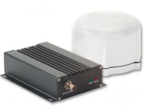
    Forsberg Services Ltd. has acquired the StarLink product line from Raven Industries. StarLink includes inline amplifiers, coaxial down/up converters and fiber-optic link systems to enable and support extended cable runs for GNSS in navigation and time synchronization applications.

    Raven Industries' Starlink GPS down/up converter makes it possible for long cable runs of 450 meters up to 1.6 kilometrers.
    Raven Industries’ Starlink GPS down/up converter makes it possible for long cable runs of up to 450 meters.

    “This opportunity provides an excellent addition to complement our range of GNSS products and services,” said Chris Mayne, Forsberg operations director. “We have worked closely with Raven Industries as a distributor of the StarLink products for the last three years and appreciate the opportunity to take the product brand forward with its customary high quality and standards.”

    Forsberg Services Ltd. is a European navigation systems integrator and OEM component supplier based in Lancaster, U.K and with offices near Hannover, Germany. The company has strong engineering experience in navigation; specializing in PCB, software and mechanical design to produce unique navigation products for a range of applications and market sectors.

    For more information, visit the Forsberg Servics website, email [email protected] or call +44-1524-383320.

  • VectorNav Unveils Updates to VN-300 GPS/INS at AUVSI Show

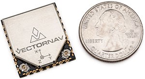
    VectorNav TechnologiesPhoto: VectorNav has released a surface mount version of its VN-300 dual-antenna GPS-aided inertial navigation system (GPS/INS). It will be on display at booth 942 at AUVSI’s Unmanned Systems show, held May 5-7 in Atlanta.

    Surface Mount Device

    The VN-300 surface mount device (SMD) is a miniature MEMS-based inertial navigation module that includes both inertial navigation and GPS-compassing capabilities, which together provide high-accuracy position and velocity in both stationary and moving conditions. With the release of the surface mount version, VectorNav is also announcing the addition of GNSS capability to the full VN-300 product line. The VN-300 SMD completes VectorNav’s line of industrial grade inertial sensors, joining the VN-100 IMU/AHRS and VN-200 GPS/INS surface mount and Rugged modules.

    Incorporating the latest MEMS sensor technology, the VN-300 combines 3-axis accelerometers, 3-axis gyros, 3-axis magnetometers, a barometric pressure sensor, two GPS receivers, and a low-power microprocessor into a rugged aluminum enclosure about the size of a matchbox. When in motion, the VN-300 couples the position and velocity measurements from the onboard GPS receivers with measurements from the onboard inertial sensors to provide position, velocity, and attitude estimates of higher accuracies and with better dynamic performance than a standalone GPS receiver or Attitude Heading Reference System (AHRS).

    With the release of the surface mount version of the VN-300 the company says its own Rugged is surpassed as the smallest and lightest dual-antenna GPS/INS on the market. The surface mount VN-300 shares the same footprint and form factor with VectorNav’s surface mount VN-100 IMU/AHRS and VN-200 GPS/INS.

    “The VN-300 surface mount chip is an achievement that combines the best of our expertise in inertial navigation algorithms and our innovative approach to miniaturizing embedded navigation sensors. There simply is no other product like it on the market,” said ohn Brashear, VectorNav’s president. “The VN-300 SMD completes our Industrial Series of inertial navigation sensors and paves the way for the expansion of our product lines into new markets and applications.”

    The VN-300 is ideal for industrial and military applications that are size, weight, power and cost (SWAP-C) constrained, or that require an inertial navigation solution under both static and dynamic operating conditions, especially in environments with unreliable magnetic heading such as fixed-wing and multirotor UAVs, aerostats and other tethered UAVs, gimbaled camera systems onboard helicopters and multirotors, antenna systems onboard ground vehicles and marine vessels, weapons training and warfare simulation, and direct surveying.

    New GNSS Capability

    With the release of the surface mount version, VectorNav is also announcing the addition of GNSS capability to the full VN-300 product line.

    The addition of GNSS capability now enables the VN-300 product line to include measurements from satellites in the GLONASS constellation in addition to GPS. These additional measurements provide greater tracking reliability and improved VN-300 performance in urban canyons and reduced visibility conditions.

    Firmware Update

    VectorNav is also announcing the release of a new firmware update for the VN-300 that improves the overall accuracy and time to acquisition of the GPS-compass feature. The new firmware also includes logic that enables the VN-300 to intelligently and seamlessly transition between magnetic heading (AHRS) mode, to INS operation in dynamic conditions and GPS-compass in static conditions, without requiring input from the user.

  • FAA Hits Milestone for NextGen Air Traffic Control

    U.S. Transportation Secretary Anthony Foxx today announced a significant NextGen milestone with the completion of En Route Automation Modernization (ERAM), a highly advanced computer system used by air traffic controllers to safely manage high-altitude traffic.

    ERAM was designed to be the operating platform for NextGen technologies, including the Automatic Dependent Surveillance-Broadcast (ADS-B) system. ADS-B transmits information about altitude, airspeed and location derived through GPS from an equipped aircraft to ground stations and to other equipped aircraft in the vicinity. Air traffic controllers use the information to “see” participating aircraft in real time with the goal of improving traffic management.

    “Looking at the future of air travel, we know that there will be more planes in our skies and more people in our airports, and in order to meet this challenge we must integrate cutting-edge technology into our aviation system,” said Secretary Foxx.  “ERAM is a major step forward in our relentless efforts to develop and implement NextGen. With this new technology, passengers will be able to get to their destinations, faster, safer, and have a smoother ride — all while burning less fuel to get there.”

    ERAM is the backbone of operations at 20 of the Federal Aviation Administration’s (FAA’s) en route air traffic control centers. The system, a crucial foundation for NextGen, drives display screens used by air traffic controllers to safely manage and separate aircraft.

    “ERAM gives us a big boost in technological horsepower over the system it replaces,” said FAA Administrator Michael Huerta. “This computer system enables each controller to handle more aircraft over a larger area, resulting in increased safety, capacity, and efficiency.”

    The first ERAM system went online at Salt Lake City Center in March 2012.  The final installation was completed last month at New York Center.

    ERAM uses nearly two million lines of computer code to process critical data for controllers, including aircraft identity, altitude, speed, and flight path. The system almost doubles the number of flights that can be tracked and displayed to controllers.

    Other NextGen technologies include:

    • Automatic Dependent Surveillance-Broadcast (ADS-B): The FAA is moving steadily toward replacing the old system of ground-based radars to track aircraft with one that relies on satellite-based technologies, including GPS. ERAM already receives information from aircraft equipped with ADS-B and displays that data on controllers’ screens. This technology has made it possible for controllers to provide radar-like separation to aircraft that previously operated in areas where no radar is available, such as the Gulf of Mexico and large parts of Alaska. ADS-B will replace radar as the primary means of tracking aircraft by 2020.
    • Performance Based Navigation (PBN): Controllers are already using ERAM to make use of Performance Based Navigation (PBN) procedures that enable controllers and flight crews to know exactly when to reduce the thrust on aircraft, allowing them to descend from cruising altitude to the runway with the engines set at idle power, saving on flying time and fuel consumption.
    • Data Comm: To reduce congestion on radio frequencies, the FAA and the aviation industry continue to develop Data Comm, which will allow controllers and pilots to communicate by direct digital link rather than voice, similar to text messaging. ERAM is already equipped to handle this technology.

    Secretary Foxx and Administrator Huerta attributed the success of the development and installation of ERAM to the collaboration between FAA management and labor, including the National Air Traffic Controllers Association (NATCA) and the Professional Aviation Safety Specialists (PASS).  This collaborative process is now a blueprint that will be applied to the rollout of future technologies.

    To see how ERAM works, watch the FAA’s video.

  • CHC Introduces LT500 Series GNSS Handheld

    CHC Introduces LT500 Series GNSS Handheld

    Photo: CHC

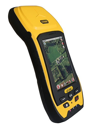
    CHC has launched the LT500 series of handheld GPS receivers. The LT500 series LT500N /LT500T/LT500H covers three accuracy ranges from sub-meter to centimeter accuracy and is a cost-effective full GNSS positioning solution for survey, construction and GIS professionals.

    Powered by the Windows Embedded Handheld 6.5 operating system, the LT500 is accurate, rugged and versatile, CHC said. User productivity is enhanced with the built-in gyroscope, an innovative laser plummet for positioning the accurate handheld receiver over a point, an E-compass for showing the direction and G-sensors for leveling.

    The LT500 series is competitively priced and comes with several bundled software programs, including SurvCE, DigiTerra, MapCloud and other third-party software.

    “CHC’s LT500 series is our brand-new GNSS handheld, which has amazing features and specifications. It meets more customers’ needs with more options and affordable prices,” said George Zhao, CEO of CHC. “The introduction of the LT500 demonstrates CHC’s commitment to provide the GIS community with a full spectrum of rugged, cost-effective professional GPS handhelds.”

    The CHC LT500.
    The CHC LT500.

    The LT500 series features these specifications:

    • 1-GHz high-speed CPU with 512-MB RAM and 16-GB flash memory built-in
    • Three tracking options:
      • LT500H 120 channel GPS L1/L2/L2C,GLONASS G1,G2,BeiDou B1, Galileo E1 Tracking
      • LT500T 220 channel L1,G1,B1
      • LT500N 12 channel L1
    • 13-hour battery: 11.1V, 2600mAh
    • Gyro, laser-plummet, E-compass, G-sensor

    The LT500 series is available immediately through CHC’s worldwide distribution channel.

  • GNSS Students Sought for ESA Summer School

    Students still have time to join the ESA International Summer School on Global Navigation Satellite Systems, which will take place in Barcelona, Spain, at the end of August.

    The 10-day course — lasting from the afternoon of Aug. 31 to the morning of Sept. 10 — will cover all aspects of satellite navigation, up to and including the creation of a satnav-based business.

    Hosted by the University of Barcelona at the four-star Hotel Alimara, the Summer School is open to graduate students, PhDs and postdoctoral researchers, as well as young engineers and academics working within industry or agencies, aged 35 or younger.

    Internationally renowned scientists and specialists will be giving lectures as well as overseeing practical exercises and lab work. Participants will receive a full-spectrum overview of satellite navigation, starting from the theoretical basis of the Global Navigation Satellite System (GNSS), its signals, the processing performed by signal receivers and how the position-navigation-time solution is worked out.

    Discussion will also be made of threats to satnav systems, such as spoofing or jamming, and the countermeasures available against them, along with back-up navigation solutions for a GNSS-denied environment.

    Practical exercises will include receiving the various satnav constellations now in orbit — including Europe’s eight-satellite Galileo, the foundation of the full system soon to come — to give course members direct, hands-on experience.

    In addition, lectures will cover business aspects, including patents and intellectual property rights.

    The main emphasis of the course will be the development of a group business project, building on an innovative idea to take in the planning of the product or service, its technical realization and finally its marketing to customers.

    Register before the end of May to benefit from an early registration discount. The number of participants is limited to 50, on a first-come, first-served basis.

    The ESA International Summer School is taking place in conjunction with the GNSS Summer School of the Joint Research Centre of the European Commission, and is organized by Universitat Politecnica de Catalunya (UPC) in cooperation with Stanford University in the US, the Institut Supérieur de l’Aeronautique et de l’Espace in France, Graz University of Technology in Austria and University FAF Munich in Germany.


  • u-blox Joins CAR 2 CAR Communication Consortium

    u-blox, a wireless and positioning module maker, has become a member of the CAR 2 CAR Communication Consortium. The industrial-driven consortium is dedicated to the development and deployment of Cooperative Intelligent Transport Systems (C-ITS).

    The consortium’s ultimate goal is to improve road traffic safety and efficiency. It is working to develop roadmaps for vehicle-to-vehicle (V2V) and vehicle-to-infrastructure (V2I) communications and to harmonize related standards. Lane-accurate positioning and short-range communication technology, both a focus of u-blox, play an important role for ITS applications.

    u-blox is a provider of wireless positioning and communications modules and chips to the automotive industry. “We see the work of the CAR 2 CAR Communication Consortium as pivotal to the success of C-ITS deployment, both in Europe and further afield,” u-blox CEO Thomas Seiler said. “Its working groups and technical committee are undertaking very important work to ensure that vehicle communications technologies will contribute to saving lives and reduce injury by making our roads safer. We’re delighted to be able to contribute to that effort.”

  • FAA Grants Topcon UAS Exemption for Sirius

    FAA Grants Topcon UAS Exemption for Sirius

    Sirius-Topcon-UAS-O

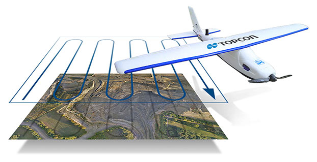
    Topcon Positioning Systems has received a national exemption from the Federal Aviation Administration (FAA) that allows for operation of its unmanned aerial system (UAS) in the United States. The exemption covers the operation of the Sirius Basic and Sirius Pro for aerial data collection.

    In early April, the FAA issued 30 more commercial exemptions, bringing the total to 99. That number has since grown to 235.

    The Sirius Pro and Sirius Basic systems are designed to produce accurate solutions for the automated mapping of a wide range of sites — regardless of terrain — including construction sites, mines and quarries. The UAS are designed for land surveying, transmission line and pipeline inspection, and agricultural operations such as field mapping and livestock management. With the Sirius Pro model, Topcon eliminates the need for ground-control points by combining real-time kinematic (RTK) GNSS solutions with precision timing technology to provide accurate mapping results, Topcon said.

    “This exemption is exciting news for the U.S. marketplace,” said Eduardo Falcon, executive vice president and general manager of the Topcon GeoPositioning Solutions Group. “It allows Topcon to be a resource for end-users and provide UAS demonstrations and training. Aerial data collection has a strong impending impact on all the industries we serve, and the possibilities for survey, construction, and agricultural applications are seemingly limitless.

    “Building on the success the Sirius models have already seen in the European and Australian markets, this exemption allows Topcon to expand on that momentum in the U.S.,” Falcon said.

  • Schweitzer Labs Adds PTP Support to Network Clock

    Schweitzer Labs Adds PTP Support to Network Clock

    Graphic: Schweitzer Labs

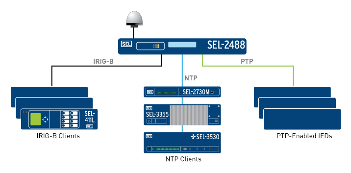
    Schweitzer Engineering Laboratories, Inc. (SEL) has added support for the Precision Time Protocol (PTP) to its SEL-2488 Satellite-Synchronized Network Clock. In a single clock, users can now synchronize end devices with sub-microsecond accuracy using demodulated IRIG-B and/or PTP. The SEL-2488 can meet all the timing needs of industrial and utility applications.

    The SEL-2488 offers security features, including Satellite Signal Verification in which the clock uses two satellite constellations to validate time signals, providing a layer of protection from GPS spoofing attacks. For fault tolerance, customers can opt for a second, redundant hot-swappable power supply, which can be connected to a second power input source. If GPS is lost, the clock switches to a standard TCXO holdover with 36-microsecond-per-day accuracy or an optional OCXO holdover with 5 microsecond average accuracy. The clock operates over a wide temperature range of –40° to +85°C (–40° to +185°F) and is backed by SEL’s 10-year, no-questions-asked worldwide warranty.

    In addition to providing IRIG-B and NTP outputs, the SEL-2488 can now serve as a PTP grandmaster clock, supporting both the default profile (IEEE 1588-2008) and the power system profile (IEEE C37.238). The SEL-2488 is capable of synchronizing time for up to four independent networks with a time-stamp accuracy of 100 nanoseconds. Existing users of the SEL-2488 can purchase this as a firmware upgrade.

    “Now there’s a choice,” said Shankar Achanta, R&D manager for precise time and wireless networks at SEL. “You can use different timing protocols based on your infrastructure and application needs. The SEL-2488 is the one network clock that can meet all our customers’ timing needs.”

    The SEL-2488 was first released in September 2014. SEL included several security features such as Syslog, the Ethernet standard for event messaging, which allows the SEL-2488 to integrate smoothly into a customer’s existing event system; role-based accounts and Lightweight Directory Access Protocol (LDAP) for user authentication; and a secure HTTPS web interface, which provides a graphical SkyView display for troubleshooting signal or antenna issues. The SEL-2488 also meets and exceeds IEEE 1613 Class 1, an electric transient and interference standard for communications products.

    Designed, tested and manufactured in Pullman, Wash., a standard SEL-2488 configuration, including a dual-constellation, high-gain GNSS antenna, retails for $2,700. The PTP firmware upgrade option for existing users costs $1,750. To learn more about the PTP enhancement in the SEL-2488, visit www.selinc.com/p222.

  • Trimble Expands Product Line for Surveyors

    Trimble Expands Product Line for Surveyors

    Photo: Trimble

    Trimble has expanded its portfolio of geospatial solutions for surveyors, engineers and mapping professionals. Highlights include new total stations, a new GNSS receiver and new field and office software features. The solutions save time, reduce costs, streamline workflows and produce high-quality geospatial deliverables across a wide range of industries, Trimble said.

    “Trimble’s portfolio expansion will enable our customers to work in a more efficient, seamless and collaborative manner,” said Chris Gibson, vice president of Trimble. “Trimble’s solutions are best known for quality, dependability and performance. Our vision is to equip customers with the most innovative tools, which includes a focus on offering new software applications that streamline and elevate the value of geospatial data to guide smart decision-making and transform the way organizations work.”

    The expanded portfolio of productivity solutions include:

    GNSS Solutions

    The new Trimble R8s Integrated GNSS receiver and updated version of Trimble Access field software combine to offer configurable and scalable settings. Surveyors have the flexibility across their workflows by being able to tailor the Trimble R8s receiver with the updated field software for their specific application. The ability to customize provides flexibility for future business requirements and allows customers to maximize efficiencies across their workflows.

    Total Station Solutions

    Trimble-totalstations-W

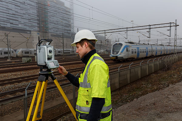
    A range of new and enhanced robotic total stations — the Trimble S5, S7 and S9 — improve project efficiencies, productivity and deliverables. Times saving enhancements include improved Trimble VISION technology, SureScan technology included in the S7 and optional in the S9 total station, and the DR Plus electronic distance measurement technology as a standard feature.

    Theft and loss risks are also minimized now with Locate2Protect technology embedded in each instrument, allowing users to remotely track the location of their equipment in real-time using Trimble InSphere Equipment Manager.

    In the office, Trimble Business Center software can be used to create high-dynamic-range (HDR) images using data captured with total stations. A new total station data editor enables fieldwork to be rapidly reviewed and allows surveyors to create deliverables with confidence, Trimble said.

    Scanning Solutions

    Trimble continues to blend powerful 3D laser scanning and imaging hardware with workflow-based software to drive new efficiencies for survey applications and construction planning and design.

    The Trimble TX8 3D laser scanner now offers greater accuracy (down to 1 mm) and streamlined onboard operation when measuring to longer ranges, decreasing the field time required for capturing reliable high-accuracy data.

    Enhanced tools in Trimble RealWorks software version 9.1 further reduce the time to produce high-quality deliverables from Trimble TX8 data. The new version of Trimble RealWorks software includes improved workflows for creating floor settlement plans and 3D pipeline models as well as complete storage tank inspection and reporting capabilities.

    cameraSightImage_S6-W

    Imaging Solutions

    Trimble enhancements to Trimble VISION workflows increase the value of highly accurate image data. Survey, engineering and civil infrastructure professionals can now generate dense point cloud deliverables in Trimble Business Center from images captured using the Trimble V10 Imaging Rover. Users can also quickly generate 2D CAD and 3D real-world models from images captured with Trimble total stations using the streamlined workflows created within Trimble Business Center and SketchUp software.

    Availability

    Trimble Access field software, Trimble Business Center version 3.50 office software, the Trimble R8s GNSS receiver, Trimble S5, S7 and S9 Total Stations and TX8 3D Scanner are available now through Trimble’s Geospatial Distribution Channel.

  • Project Counters Ionospheric Disturbance for GNSS

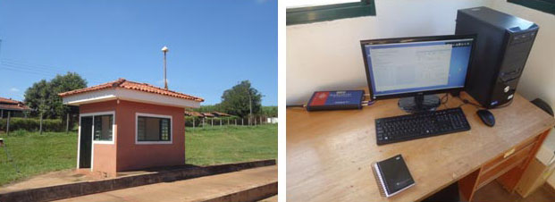
    The monitoring station in Brazil uses a Septentrio PolaRxS receiver to monitor the ionosphere, a Septentrio AsteRx3 to perform tests static and kinematic tests, and three RTK Altus APS3 receivers (one as a base station and two as rovers.)
    The monitoring station in Brazil uses a Septentrio PolaRxS receiver to monitor the ionosphere, a Septentrio AsteRx3 to perform tests static and kinematic tests, and three RTK Altus APS3 receivers (one as a base station and two as rovers.)

    After 27 months of intensive research, a project team funded under the European Union’s 7th Framework Programme has come up with a solution to counter the problem of ionospheric disturbance affecting GNSS signals.

    The CALIBRA project recently showcased a commercially applicable approach to mitigate the phenomenon’s impact on high-accuracy GNSS positioning techniques. In  two demonstrations, the project’s newly developed algorithm was successfully tested in actual precision agriculture and offshore operations.

    Solar flares can cause ionospheric disturbance, a sudden increase in radio-wave absorption that often delays the propagation of signals and ultimately affects positioning. The problem has kept researchers busy for years.

    The CALIBRA project team has been participating in this global research effort by focusing on Brazil, which is one of the most exposed regions due to its proximity to the magnetic equator. Add to this that the sun is at its peak of activity since it entered its new 11-year cycle in 2010.

    The project achieved three main milestones. First, the team confirmed that ionospheric scintillation and variations in total electron content (TEC) had a direct impact on the functioning of high accuracy GNSS techniques, such as Precise Point positioning (PPP) and real-time kinematic (RTK) positioning. Then a suitable metric was established to characterize these ionospheric disturbances. Finally, the project produced a short-term empirical model for forecasting TEC and scintillation. A regional TEC map was developed which proved advantageous for use in Brazil and, to counter scintillation, a number of approaches for the mitigation of this phenomenon were proposed and their benefit demonstrated.

    The project exploited the CIGALA-CALIBRA network and database — a network of ionospheric scintillation monitor receivers with a web interface (the ISMR Query tool), which collects more than 10 million observations on GPS, GLONASS, Galileo, BeiDou and other global navigation systems every day. Since it was launched in December 2014, this data has helped assist users from more than 20 countries because of the software’s visualization and mining techniques.

    In light of this success, CALIBRA partners INGV (Istitute Nazionale di Geofisica e Vulcanologia) filed a patent for their forecasting model, and a new spin-off company — SpacEarth Technology — was set up. SpacEarth’s main purpose is to secure the software’s commercialization in relevant applications and services, while also improving and adapting it to evolving market needs.

    The project’s results promise to considerably reduce downtime and financial losses caused by ionospheric disturbance in Brazil and other regions of the world. Learn more about the project here.

    Another ionospheric mitigation project was presented at the European Navigation Conference earlier this month.

  • J.D. Power: Collision Tops Nav, Paves Way for Autonomous Driving

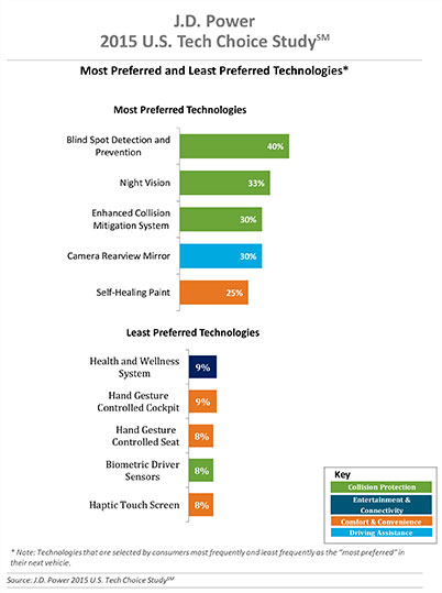
    Three of the top five technologies consumers most prefer in their next vehicle are related to collision protection, according to a new J.D. Power 2015 U.S. Tech Choice Study.

    Technologies that reduce the overall burden of driving and enhance the safety of the vehicle and its occupants receive the most consumer attention. Among the technologies consumers express most interest in having in their next vehicle are blind spot detection and prevention systems, night vision, and enhanced collision mitigation systems. These findings demonstrate growing customer acceptance towards the concept of the vehicle taking over critical functions such as braking and steering, which are the foundational building blocks leading to the possibility of fully-autonomous driving. The only non-collision protection technologies to crack the top five are camera rearview mirror, which falls into the driving assistance category, and self-healing paint, a comfort and convenience category.

    In contrast, technologies in the navigation category have low preference across all vehicle price segments.

    The inaugural study uses advanced statistical methodologies to measure preference for and perceived value of future and emerging technologies. A total of 59 advanced vehicle features are examined across six major categories: entertainment and connectivity; comfort and convenience; collision protection; driving assistance; navigation; and energy efficiency.

    “There is a tremendous interest in collision protection technologies across all generations, which creates opportunities across the market,” said Kristin Kolodge, executive director of driver interaction and HMI research at J.D. Power. “In contrast, there is very little interest in energy efficiency technologies such as active shutter grille vents and solar glass roofs. Owners aren’t as enthusiastic about having these technologies in their next vehicle because of other efforts automakers are taking to improve fuel economy, as well as relatively low fuel prices at the present time.”

    Chart: J.D. Power

    Gen Y Willing to Spend Most for Technology

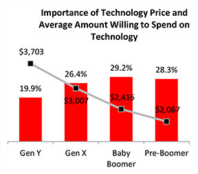
    Across all generations, price is the most important consideration for technology, accounting for 25.2 percent of importance. Gen Y is the least sensitive to technology price and shows a greater willingness to spend on new technologies than the other generations. Gen Y consumers, who have accounted for 27.7 percent of new-vehicle sales thus far in 2015 — second only to Boomers at 37.1 percent — are willing to spend an average of $3,703 on technology for their next vehicle. Gen X is willing to spend $3,007, while Boomers, who show the greatest price sensitivity, and Pre-Boomers are willing to spend only $2,416 and $2,067, respectively.

    Chart: J.D. Power

    Importance of Technology

    A certainty in the automotive domain is the impact the consumer electronics world has had upon it. From shifting consumer expectations of user interaction, to the rapid pace of technology introduction and importance of keeping software up to date, to the miniaturization and creation of cost-effective solutions for sensors and cameras, “the auto industry is standing on its head to keep technology up to consumers’ new standards,” said Kolodge. “Those who haven’t done so have seen negative feedback from consumers.”

    Apple CarPlay vs. Google Android Auto

    Smartphones play an increasingly vital role in everyday life, and vehicle technology is beginning to mirror what is offered on those devices, yet Apple CarPlay and Google Android Auto technologies consistently have among the lowest preference scores across all generations.

    Consumer preferences for Apple CarPlay and Android Auto are uniquely dependent on which smartphone they own. Those who currently own a smartphone that is compatible with one of these technologies would choose the technology compatible with their phone at only a moderate rate, while those with the opposite brand of smartphone will rarely, if ever, choose that technology. For example, Android owners indicate that Apple CarPlay is “unacceptable” nearly twice as often as they indicate that solar glass roof is unacceptable.

    Similarly, Apple phone owners indicate that Android Auto is “unacceptable” nearly twice as often as solar glass roof.

    Kolodge noted that “lukewarm interest in these technologies that connect your phone to your vehicle coupled with consumer loyalty to their phone poses a unique challenge for automakers, which could be remedied by knowing their customers’ phone preferences.”

    “Owners of luxury vehicles tend to own iOS devices, 1 so for many luxury brands, offering Apple CarPlay may be the best option, realizing they may be leaving out a portion of the market,” said Kolodge. “For nonluxury vehicle brands, the ownership of Apple and Android devices is much closer to an equal split. The solution for those brands may be to offer both operating systems and allow customers to select the option best suited for them.”

    Key Findings

    • Full self-driving automation technology, part of the collision protection category, is designed to perform all safety-critical driving functions and monitor roadway conditions. The younger generations (Gen Y and Gen X) have substantially higher preference for the technology than the older generations (Boomer and Pre-Boomer). The Pre-Boomer generation, in contrast, has a greater preference for lower levels of automation, such as traffic jam assist.
    • Blind spot detection and prevention has high preference across the range of vehicle price segments. In contrast, reverse auto braking systems have low preference across the vehicle price segments and preference wanes as vehicle prices increase.
    • Advanced sensor technologies, such as hand gesture controlled seats, biometric driver sensors or haptic touch screens have low preference.
    • Technologies in the navigation category have low preference across all vehicle price segments.

    The 2015 U.S. Tech Choice Study was fielded in January through March 2015 and is based on an online survey of more than 5,300 consumers who purchased/leased a new vehicle in the past five years.