The Global Positioning System marks its 20th year of operation on Monday, April 27. Below is a timeline showing important milestones in the 20 years since the constellation reached full operational capability (FOC) on April 27, 1995.
With Exelis RangeVue, a high-performance GIS visualization engine provides real-time updates of critical operational elements.
Exelis has launched its first airspace situational awareness tool designed specifically for unmanned aerial system (UAS) operations in the United States. Symphony RangeVue puts real-time Federal Aviation Administration (FAA) surveillance data, flexible background maps and weather information in the hands of UAS operators and test range personnel. The system provides significant improvements to the safety and efficiency of UAS operations, whether on the test range or in the field.
Symphony RangeVue enables UAS operators and test range personnel to have access to both real-time and historical surveillance information via a web-hosted platform, helping to manage mission operations from multiple locations with full visibility of assets. Symphony RangeVue can be used as a command center decision-support and post-event analysis tool, or in the field as a sense-and-avoid addition to UAS ground control stations. Flexible geo-fencing tools alert operators when a UAS approaches airspace boundaries or when other aircraft are in the vicinity.
“For the first time, UAS operators and test range personnel will have the same situational awareness currently available to general aviation pilots through traffic information broadcast services. This capability is available without having to install avionics surveillance equipment on the UAS aircraft,” said Ed Sayadian, vice president of Civil and Aerospace Solutions for Exelis. “Leveraging the FAA’s own surveillance data combined with advanced sense-and-avoid alerting capabilities, Symphony RangeVue will significantly increase the safety of UAS operations.”
Symphony RangeVue combines a high-performance visualization engine with the vast network of Exelis NextGen surveillance data, including all of the FAA’s surveillance systems: automatic dependent surveillance-broadcast; en route radar; terminal radar; airport surface detection equipment-X; airport surface surveillance capability; and wide area multilateration. It also integrates locally deployed surveillance assets to deliver hyperlocal situational awareness.
TomTom is partnering with Mozilla and Telefónica to bring its Maps Online and Nav Online apps to HTML5-powered Firefox OS smartphone devices.
“We’re thrilled to offer Firefox OS users TomTom’s Maps Online and Nav Online apps in the Firefox Marketplace,” said Bertrand Neveux, director of Marketplace and Ecosystem at Mozilla. “Our priority is to empower users with a mobile experience that makes their lives richer and more efficient, and great content like TomTom’s ensures that.”
“Telefónica has now launched Firefox OS devices in 14 markets and is pleased to see high-quality maps and navigation solutions from TomTom that enhance these devices for our consumers in Latin America and Europe,” said Simon Callan, director Business Development at Telefónica.
“TomTom is excited to be embracing the openness of HTML5 to bring high quality maps and turn-by-turn navigation to the ecosystem,” said Charles Cautley, managing director of TomTom Licensing. “By partnering with Mozilla and Telefónica, we’re opening new markets and opportunities for smartphone users globally.”
TomTom Maps Online offers accurate and up-to-date maps, as well as Address and Point of Interest search capabilities with routing instructions, enabling Mozilla customers to quickly and easily find their favorite places, TomTom said.
With TomTom Nav Online, Telefónica’s Firefox OS customers can extend the mapping experience to full voice-guided turn-by-turn navigation.
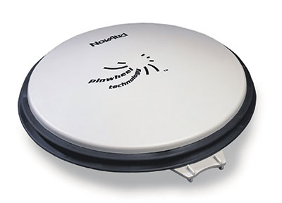
NovAtel Inc. has launched the GPS-704-WB wideband antenna, which supports L-band and the frequencies of all current GNSS constellations (GPS, GLONASS, Galileo and BeiDou), including B3 and E6 signals. Customers can use the antenna for GPS-only or multi-constellation applications, giving application developers flexibility, NovAtel said.
The phase center offset of the antenna remains constant as the azimuth and elevation angle of the satellites change, making it a good choice for baselines of any length. Installation is easy, NovAtel said. because the antenna shares the same form factor as other NovAtel GPS-700 series antennas. It is enclosed in a durable, waterproof housing. Its compact, lightweight size makes it suitable for a wide variety of environments and applications, the company said.
CBS’s 60 Minutes will air a special two-part segment on Air Force Space Command (AFSPC) this coming Sunday, April 26, reflecting a broad array of AFSPC missions — launch, satellite operations, missile warning, acquisition, and the Joint Space Operations Center.
The GPS Directorate is a joint service effort directed by the United States Air Force and managed at the Space and Missile Systems Center (SMC), Air Force Space Command, Los Angeles Air Force Base, Calif.
“The show seldom uses two-part segments, and the producers expressed that the visually interesting nature of the mission and intellectual heft of the interviews was the deciding factor in expanding the segment beyond the normal 12 minutes,” reads an email from the Retiree Activities Office of Los Angeles Air Force Base.
Included in the segment is an interview with Brigadier General Bill Cooley, director of the GPS Directorate. Cooley was interviewed at the Boeing facility in front of a GPS IIF satellite, and will discuss the foundational nature of space to the military and economy, as well as emerging threats and how the Air Force is responding.
60 Minutes airs on CBS at 7 p.m. ET/PT. Check local listings for specific times and channels.
Delta Airlines made a perfect Ground-Based Augmentation System (GBAS) Landing System (GLS) landing at Liberty Newark International Airport on Feb. 18, according to the Federal Aviation Administration’s SatNavNews newsletter.
Delta now joins United Airlines and British Airways as airlines that use the GBAS at Newark.
More GBAS locations around the world are reaching operational status, and airline operations using GBAS are increasing as additional GLS-equipped aircraft are entering service for the various airlines. Boeing has confirmed that many of the customers who have ordered multiple 787s, 747-8s or 737s have publicly stated their intention to use the GLS capability on these aircraft.
More than 1,000 Boeing GLS-equipped aircraft are now in use, and this number is growing by an estimated 25 airplanes per month. This estimate is based upon current production rates — one third of 737s are being equipped with the GLS option. GLS is standard on 787 and 747-8 aircraft.
The list below provides a summary of the airlines using GBAS and the airports where GLS approaches are flown on a regular basis.
U.S. Carriers
Delta Airlines – Houston, Newark
United Airlines – Houston, Newark
Non-U.S. Carriers
Air Berlin – Bremen, Malaga
British Airways – Newark
Cathay Pacific – Houston, Sydney (plans for Newark in the future)
Various Russian airlines (S7, Transaero, Utair, Sakhalin Energy, Gaspromavia Russia). Fifteen GBAS locations in Russia have been approved with each airline using different airports (Domodedovo, Pulkovo, Tyumen, Ostafyevo, Nogliki and others).
The commitment to GBAS development and implementation continues to grow, according to the FAA, with plans to implement GBAS in these additional locations:
The GPS/GNSS International Symposium was first held in 2000 in Seoul and has been held annually ever since, rotating among Korea, China, Japan, Australia, Malaysia and Taiwan. The 2008 meeting in Tokyo attracted 428 attendees, including 179 foreign delegates, and 188 papers were presented. The 16th Symposium will be held in Kyoto, a beautiful historic city and the ancient capital of Japan.
Important dates for paper submission:
June 30 : Abstract Submission for Scholarship application and Refereed Papers
July 31: Full paper Submission for Scholarship application and Refereed Papers
August 15: Abstract Submission for Regular Papers
September 15: Acceptance Notification
October 15: Full Paper Submission.
Registration dates:
Early-bird registration: April 1 – August 18
Regular registration: August 19 – October 31
Session tracks include:
Global Satellite Navigation Systems (GPS, GLONASS, Beidou, Galileo)
QZSS and Regional Systems
Augmentation Systems (SBAS, GBAS, etc.)
Next-Generation GNSS
Inertial Systems for Positioning & Orientation
Signal Processing in Navigation Systems and Systems Integration
James L. Green, director of Planetary Science for NASA.
James L. Green, director of Planetary Science for NASA, will take the audience on a journey navigating through the solar system at The Institute of Navigation’s ION GNSS+ 2015 Conference.
Green’s keynote address will show new worlds and new discoveries through the eyes of NASA’s planetary spacecraft. The conference takes place Sept. 14-18 at the Tampa Convention Center in Tampa, Florida.
At NASA, Green is responsible for solar system exploration including astrobiology research. Under his leadership, a number of recent planetary science mission events have been successfully completed, including the New Horizons space probe which is scheduled to reach Pluto on July 14, Messenger orbit insertion at Mercury, the launch of Juno to Jupiter, the launch of Grail A and B to the Moon and subsequent orbit insertion, Dawn’s encounter with Vesta, and the landing of the Mars Science Laboratory and Curiosity rover on Mars. He has published more than 100 scientific papers on the magnetosphere of Earth and Jupiter. He has also contributed more than 50 technical articles on various aspects of data systems and networks.
Green received his Ph.D. in physics from the University of Iowa in 1979 and has worked at NASA’s Marshall Space Flight Center and Goddard Space Flight Center before becoming the director of the Planetary Science Division at NASA Headquarters in 2006. In 1988 he received the Arthur S. Flemming award given for outstanding individual performance in the federal government and was awarded Japan’s Kotani Prize in 1996 in recognition of his international science data management activities
Sponsored by the ION’s Satellite Division, ION GNSS+ is the world’s largest international technical meeting and showcase of GNSS technology, products and services and brings together international leaders in GNSS and related positioning, navigation and timing fields to present advances, introduce new technologies, update current policy, demonstrate products and exchange ideas.
The Brevis GNSS antenna is the latest addition to Antenova’s gigaNOVA family of miniature antennas. The small antenna is designed to be used in portable handheld devices that have GNSS receivers — for example, in devices and applications that have a tracking capability or location accessories such as in transport, navigation, wearables and eHealth.
The multi-GNSS antenna is designed for embedded applications, with a high efficiency-to-size ratio. It is intended for use in applications where there is no ground beneath the antenna. It has near omni-directional characteristics which will provide good performance for any device.
The Brevis operates with the following GNSS bands: GPS, GLONASS, Galileo and BeiDou. Brevis GNSS is a low-profile, small-footprint antenna designed for surface-mount device (SMD) mounting, so it can simply be placed on a printed circuit board (PCB) to add wireless connections to any device.
Full technical specifications for the Brevis GNSS antenna and contact details for regional distributors are available on Antenova’s website.
GPS IIF-9, launched March 25, has been declared healthy and operational by the U.S. Air Force. The Air Force issued the following Notice to NAVSTAR Users (NANU).
The next GPS satellite, GPS IIF-10, is scheduled for launch on June 16, with GPS IIF-11 following three months later, on September 16.
NOTICE ADVISORY TO NAVSTAR USERS (NANU) 2015028
SUBJ: SVN71 (PRN26) USABLE JDAY 110/2222
1. NANU TYPE: USABINIT
NANU NUMBER: 2015028
NANU DTG: 202222Z APR 2015
REFERENCE NANU: N/A
REF NANU DTG: N/A
SVN: 71
PRN: 26
START JDAY: 110
START TIME ZULU: 2222
START CALENDAR DATE: 20 APR 2015
STOP JDAY: N/A
STOP TIME ZULU: N/A
STOP CALENDAR DATE: N/A
2. CONDITION: GPS SATELLITE SVN71 (PRN26) WAS USABLE AS OF JDAY 110
Tallysman’s compact GNSS TW1721 dual-feed embedded antenna with Accutenna technology.
Tallysman, a provider of high-performance, high-quality RF and GNSS components, has announced that its range of antennas featuring proprietary Accutenna technology is optimized for today’s multi-constellation satellite systems, including Europe’s Galileo, China’s next-generation BeiDou, GPS, GLONASS and India’s IRNSS.
Tallysman’s compact GNSS antenna range with Accutenna technology is future-proof: GNSS is changing, and an increasing number of receivers are capable of accessing multiple constellations — GPS, GLONASS, Galileo, BeiDou — but to provide the high precision these new generation of satellites enable also requires new antenna technology.
Tallysman’s proprietary Accutenna dual-feed patch technology used in the company’s wide range of GNSS antennas provides circular response over the entire antenna bandwidth, yielding superior multi-path signal rejection-low axial ratios, tight phase center variation (PCV), and a linear phase response. Single-feed patch antennas, by contrast, only provide a circular response at a single frequency and exhibit poor multipath signal rejection when receiving signals from two or more constellations. A pre-filtering option is available that gives additional protection from near out-of-band signals if required.
“Today’s wideband GNSS signals require a pure right-hand-circular response over a much wider bandwidth,” said Gyles Panther, president of Tallysman. “An inadequate phase response results in poor cross polarization suppression, which simply cannot be overcome in the GNSS receiver chip, regardless of its capabilities. Moreover, multipath interference can be expected, even in normal reception situations. Accutenna technology is a cost-effective way to ameliorate this and is particularly beneficial in situations where precision matters.”
In March, the European Space Agency launched two additional satellites (Galileo 7 and 8). Also in March, the United States launched GPS IIF-9, India launched IRNSS-1D, and China successfully launched its new generation BeiDou-3 M1. The expanding number of satellites will benefit many applications, from next-generation in-car navigation systems to coastguard search and rescue and precision agriculture, Tallysman said.
Parrot’s quadcopter Bebop Drone has Furuno inside.
Furuno Electric Co.’s latest multi-GNSS receiver module, GN-87, has been adopted for the new quadcopter Bebop Drone, made by Parrot SA. Parrot develops advanced technology wireless products.
The GN-87 can receive GPS, GLONASS, SBAS, and QZSS concurrently, which significantly improves positioning success rate and robustness against interferences by using different frequency bands, Furuno said.
Parrot Bebop Drone, equipped with a 14-megapixel fisheye lens camera, takes video and pictures in a 180-degree field. The drone integrates mechanical and digital systems, like shock absorbers that cushion engine vibrations and algorithms for an exclusive 3-axis image stabilization, meaning that the angle of the view remains fixed, without distortion, regardless of the inclination of the drone and movement caused by turbulence. The combination of numerous sensors gives the drone impressive stability and great maneuverability when piloted via Wi-Fi with a smartphone and a tablet, or with its Wi-Fi extender, Parrot Skycontroller.
Furuno’s GN-87 supports sensing for autonomous flying according to flight routes preset on the map application by user, automatic return to takeoff position, recording flight path data for 3D modeling on Parrot Academy map. According to Parrot, selecting Furuno’s GN-87 multi-GNSS receiver module enabled simple integration with a high-performance GNSS receiver module while guaranteeing high quality and high volume supply availability.
 The Global Positioning System marks its 20th year of operation on Monday, April 27. Below is a timeline showing important milestones in the 20 years since the constellation reached full operational capability (FOC) on April 27, 1995.