Author: GPS World Staff

  • u-blox Surface-Mount GNSS Module Supports All Satellites

    u-blox Surface-Mount GNSS Module Supports All Satellites

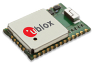
    The u-blox CAM-M8C.
    The u-blox CAM-M8C.

    u-blox is offering the CAM-M8C — a small, low-profile GNSS positioning module with an integrated wideband chip antenna for reception across the entire L1 band. The module offers simultaneous GNSS operation for GPS/GLONASS, GPS/BeiDou, or GLONASS/BeiDou to deliver accurate, jamming-resistant and reliable positioning anywhere in the world.

    The CAM-M8C integrates a u-blox M8 satellite receiver, crystal oscillator, SAW filter and low-noise amplifier. It also has an input for an external active antenna — when using this option, the internal antenna acts as a backup. Because of its design, the module maintains its performance regardless of physical orientation, making the product suitable for mobile applications with frequent change of bearing.

    “Where space is at a premium, for example in emergency call systems, in handheld navigation or in wearable devices, the CAM-M8C module offers a very cost-effective way to bring products to market quickly due to its small size and high levels of integration,” said Kim Kaisti, product manager, Product Center Positioning. “It does this without compromising performance or reliability, and leaves system designers free to concentrate on other important aspects of their product development.”

    The CAM-M8C is footprint-compatible with u-blox UC530 and UC530M modules, providing an easy upgrade path, the company said. The module is available now.

    To further accelerate design and development, an evaluation kit, EVK-M8CCAM, provides a way to become familiar with the CAM-M8C module and assess its performance in specific applications.

    The u-blox M8 GNSS receiver antenna module is delivered in u-blox Professional Grade, and is qualified to JEDS47 and ISO16750 standard “Road vehicles – Environmental conditions and testing for electrical and electronic equipment.” The product is manufactured in ISO/TS 16949 automotive-certified production sites, ensuring the high quality and reliability

  • Ford, Telogis Expand Partnership to Commercial UK Customers

    Ford Motor Company and Telogis have expanded their exclusive partnership to bring Ford Telematics powered by Telogis to Ford’s commercial customers in the United Kingdom first, with other European markets to follow later this summer. Ford Telematics uses real-time information from Ford vehicles to enable businesses with workers in the field to have insight into vehicle location, driver behavior and fuel consumption.

    The telematics can save companies up to 20 percent on fuel, according to a 2012 Frost & Sullivan report.

    Since 2011, Telogis has been the exclusive technology provider to power Ford Telematics (formerly Ford Crew Chief) in the U.S. and Canada, with comprehensive and scalable telematics for commercial customers. The UK expansion of the Telogis-Ford partnership leverages the success of Ford Telematics in the U.S. and Canada and will meet the demand from current and new Ford customers in the UK for in the visibility into day-to-day operations including Ford vehicle diagnostics.

    “Ford Telematics is an innovative system that can deliver reductions in cost of ownership for businesses that operate Ford’s Transit commercial vehicles,” said Paul McDermott, manager, CV aftersales, Ford of Britain. “Real-time vehicle location and diagnostic data provides fleet customers with a powerful tool to manage their vehicles more effectively and also encourage safer driving.”

    Making its debut at the 2015 Commercial Vehicle Show, Ford Telematics will be available to fleet customers in May as a dealer-installed option, offered through Ford’s network of specialist Transit Centres.

    Ford Telematics functions by securely transmitting vehicle data and metrics from the vehicle to a dedicated Telogis website via an embedded cellular connection. The telematics system’s ability to access proprietary Ford vehicle data enables operators to track details such as oil change warnings, water contamination in diesel fuel, tire pressure, safety belt usage and airbag status.

    “The reality of being able to visualize field staff and the performance of each Ford vehicle — all on one screen — is here,” said Paul Reynolds, automotive director at Telogis. “This visibility enables Ford commercial customers to provide better service for their own customers and run their businesses more productively and efficiently — it’s no longer a ‘nice to have’ but a ‘have to have’ solution.”

    Based on the real-time data, the Ford Telematics powered by Telogis software platform delivers a comprehensive range of actionable business information that enables fleet managers to operate their vehicles in the most efficient way and to help ensure drivers are following safe and economical driving practices.

    Advances include a suite of more than 80 pre-loaded reports, integration with established business operating systems and fuel card services. Ford Telematics and the Telogis platform also allow for a BYOD (Bring Your Own Device) approach, helping to further reduce hardware costs and increase productivity.

    Ford Telematics is compatible with Ford’s latest range of Transit commercial vehicles — including the all-new Transit, Transit Custom, Transit Connect and Transit Courier — as well as the Ford Ranger pickup. Additionally, the same Telogis hardware can be fitted to any other vehicles on the fleet, regardless of manufacturer, allowing informed fleet managers to view the whole fleet in one place, with all the usual driver performance and vehicle tracking information that they expect.

    Ford Telematics also provides a gateway to the broader cloud-based Telogis platform that includes a suite of connected vehicle technologies including route optimisation and planning, commercial-grade navigation, work order management and mobile applications to drive additional efficiencies and productivity for mobile enterprises.

    “Ford Telematics is another example of Ford facilitating the delivery of smart technology to help our customers enjoy the highest quality, safest and most sustainable operation of commercial vehicles available today,” said Nick Themistocleous, director, Fleet Operations, Ford of Britain.


  • Google Patent Seeks to Link Robots via Smartphones

    Google Patent Seeks to Link Robots via Smartphones

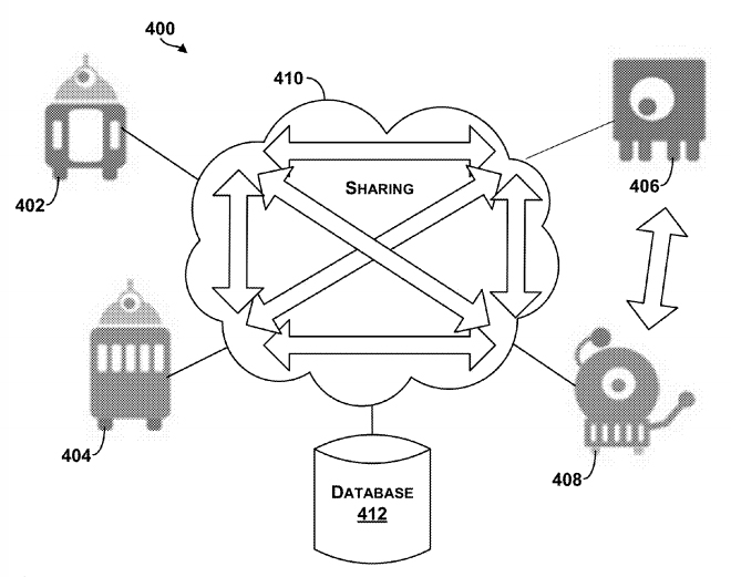
    The Google patent shows an example system in which robotic devices interact with the cloud and share information with other cloud computing devices.
    The Google patent shows an example system in which robotic devices interact with the cloud and share information with other cloud computing devices.

    In a patent awarded April 14, Google describes “systems and methods for allocating tasks to a plurality of robotic devices,” reports Nextgov.com.

    Google’s patent (Patent #9,008,839) outlines methods for connecting a series of robots over the cloud to complete tasks. A robotic device configured to perform a task could make use of a GPS receiver to determine its location. It might also use other sensors, such as a gyroscope or an accelerometer to measure movement. Other sensors could be encoders, infrared sensors, optical sensors, biosensors, Radio Frequency identification (RFID) systems, wireless sensors and compasses.

    The patent suggests that the robots could be controlled by a smartphone — from anywhere in the world.

    The patent could have value for Google’s self-driving car project, allowing the vehicles to communicate with each other.

    In another patent (Patent #US008996429), awarded on March 31, Google describes how a robot’s personality can be defined using sensors and the cloud. According to the patent, “methods and systems for robot and user interaction are provided to generate a personality for the robot.” One aspect includes basing the robot’s personality on identifying the user’s location.

    The personality and state may be shared with other robots so as to clone this robot within another device or devices. In this manner, a user may travel to another city, and download within a robot in that city (another “skin”) the personality and state matching the user’s “home location” robot. The robot personality thereby becomes transportable or transferable.

    Again, GPS is mentioned as a possible sensor for use either in the user’s smartphone, the robot, or both.

    So, in the future, when you leave home, you may be able to take an interactive non-human friend along. Talk about location-based services!


  • Fleetmatics Report Shows Retail Sales Correlate with Fleet Activity

    Fleetmatics has released the second edition of its FleetBeat Report, an in-depth analysis of tens of billions of data points extracted from thousands of commercial fleets managed using the company’s Software as a service (SaaS) platform over a span of four years. The report, “FleetBeat, Vol. 2: The Economy in Motion,” was co-authored by Stephen Fuller, Ph.D., professor and director of the Center for Regional Analysis at George Mason University.

    Fleetmatics says the data included in the report reveals that performance of small businesses in the services industry directly reflects the health of the economy.

    “It has long been said that retail sales trends are often impacted by the health of small business,” said Jim Travers, chairman and chief executive officer of Fleetmatics. “Fleetmatics is uniquely positioned to analyze small business services activity given we have one of the largest fleet management data clouds in the world. Also, our customers are typically in the earlier phases of consumer consumption, such as distribution of goods and home deliveries.”

    fleetmatics_infographic_fleetbeat2

    As outlined in the report, the data extracted from Fleetmatics fleet management data cloud suggests that performance of small business services companies can be a highly credible indicator of national and regional economic health, even under changing conditions. The report also looks at small business services performance and retail sales in four Metropolitan Statistical Areas (MSAs), and concludes that geographic features can significantly define regional small business activity profiles.

    “This is truly a groundbreaking new report, viewed from the perspective of the fleet management industry,” said Fuller. “Based on Fleetmatics’ FleetBeat second edition report, Fleetmatics data explains much of the variation and growth in retail sales. Furthermore, when comparing the Fleetmatics’ small business service fleet activity data with the retail sales data from Moody’s and the U.S. Bureau of Census, it’s clear the two data sets exhibit an extremely high correlation. I believe the ability to analyze real-time telematics data can now be considered an accurate data source on the small business flow of goods and service.”

    With a dataset of over 10.7 billion telematics-generated data points from commercial vehicles managed with the Company’s SaaS platform in the United States, the report used regression analysis to compare the data with national monthly retail sales data.

    There were eight telematics-derived, independent parameters considered in the analysis, both in aggregate and at the per vehicle level, including those related to mileage, number of vehicle stops, mileage per stop, number of active vehicle days per month and number of vehicles active in a month. The data was drawn from small business customers defined as entities having fleets from 5 to 100 vehicles, and only fleets from business types that were related to or supporting retail and service sectors were considered.

    The report also examined regional differences that drive activities of small business services companies in four markets: New York, Chicago, San Francisco and Miami. The result was an in-depth breakdown of the most prominent indicators of small business economic activity and correlation to retails sales in each core market.

    Fleetmatics’ first FleetBeat report highlighted the economic impact of telematics adoption and quantifiable benefits of business intelligence-driven fleet management. The report found that the total estimated economic impact of commercial fleet vehicles armed with telematics – assuming everyone had the same results as Fleetmatics’ optimized customers – would amount to $2.2 billion in fuel savings, a decrease in carbon dioxide emissions by 5 tons per year and $34.9 billion in total cost savings due to decrease in payroll hours.

  • GPS Glitch Two Years Older than First Stated

    On Wednesday, the GPS Directorate said further data analysis shows that a technical error affecting some Boeing GPS IIF satellites first appeared in 2011, two years earlier than originally stated, according to a Reuters report.

    The error first appeared one year after the GPS IIF satellites became operational. The error affects the way the ground control system builds and uploads messages transmitted by the satellites, but does not affect the accuracy of GPS signals. It involves the ground-based software used to index messages.

    Lockheed Martin runs the GPS ground control segment, which enables Air Force officials to operate all GPS satellites, including the IIF satellites built by Boeing.

  • Air Force to Award Additional GPS III Satellite Contracts

    The U.S. Air Force plans to award multiple contracts for companies to demonstrate their ability to build GPS III satellites, according to a report by Mike Gruss of Space News.

    The Air Force expects to award the contracts — worth up to $6 million — during this calendar year. Lockheed Martin Space Systems of Denver is the current GPS III satellite contractor, building the first eight GPS III satellites. The first satellite is expected to launch in 2017.

    The GPS III program is nearly two years behind schedule.

  • Traqueur Unveils Autonomous Mobile Beacon Nano

    Traqueur Unveils Autonomous Mobile Beacon Nano

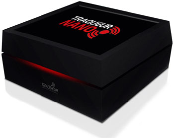
    Photo: TraqueurTraqueur, a French-based company in the field of advanced telematics, has introduced Nano, an autonomous mobile beacon for the protection of property and objects designed to optimize the potential of the Sigfox network.

    Nano uses radio and GPS to track indoor and outdoor location, has a battery life of three to five years and is named Nano for its compactness.

    In June 2014, Traqueur formed a strategic technical partnership with Sigfox, the sole operator of the global cellular network for the Internet of Things (IoT) and machine-to-machine communications.

    Nano displays functionalities of UHF direction finding, providing the ability to locate buried and hidden objects. It also has a high-sensitivity GPS module and an integrated antenna to transmit its position through the Sigfox network when the beacon moves.

    Nano’s roaming features open up prospects for international marketing.

    The development of Nano has received support from BPI Ile-de-France (Paris region).

    “Certified Sigfox Ready and provided with mixed UHF/GPS technology, the Nano beacon means that we can offer the widest range of technology solutions of the track and trace type on the market and can address new segments including merchandise and logistics, for example,” said Marc Verdet, CEO of Traqueur. “We are also accelerating our international development through distribution partnerships in every country with a SIGFOX network infrastructure.”

    “The development of this new beacon by Tracker, based on our network, is extremely innovative and shows the limitless scope for innovation that SIGFOX technology allows, “Stuart Lodge, Executive Vice President Global Sales at SIGFOX. “This technology gives by far the longest battery life on the market, a decisive advantage for applications such as the location of property. The solution developed byTraqueur, because it is very demanding, confirms the legitimacy of our technology wherever the SIGFOX network is deployed.”

    DiscoverTraqueur in forthcoming trade shows in France:

    · Flotte Auto meeting, March 19, 2015 – Palais Brongniart – Paris Stand B07

    · DLR Congress, March 26 & 27, 2015 – CNIT Paris – Stand 44

    · MtoM & Connected Objects show on April 1 & 2 – CNIT Paris – Stand E7 Conference: Innovation in value-added services around the IoT. Tracker Nano presentation workshop.

    · Intermat from April 20 to 25, 2015 – Paris -Nord Villepinte – Booth 6B022

  • Applanix Unveils Expanded Marine Product Portfolio

    Applanix Unveils Expanded Marine Product Portfolio

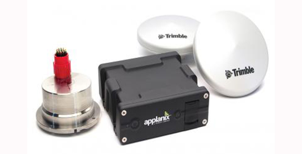
    Applanix has introduced an expanded portfolio of marine georeferencing and motion compensation solutions. Taking advantage of Applanix proprietary technology, the new line-up of marine products offers high-performance solutions to a broader cross-section of the hydrographic survey industry.

    All Applanix Marine products benefit from the optimal integration of GNSS and inertial observables, with access to Trimble GNSS technology for performance advantages.

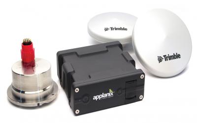
    The Applanix POS MV Surfmaster.
    The Applanix POS MV Surfmaster.

    The announcement was made at Ocean Business 2015, an exhibition of more than 300 of the world’s leading manufacturers and service providers in the industry.

    “Advances in Applanix inertial technology enable us to offer the high performance levels we are known for at even more attractive price points. By introducing this new product portfolio, we are able to deliver solutions suited to all types of bathymetric mapping,” said Peter Stewart, director of Marine Products. “This revised product lineup demonstrates Applanix’ continued commitment to provide customers with options that best fit their budget and requirements.”

    At the entry level of the expanded product portfolio, Applanix introduced the new POS MV SurfMaster. Incorporating Applanix’s proprietary SmartCal inertial calibration techniques, POS MV SurfMaster delivers robust georeferencing for small platforms, both manned and unmanned. SurfMaster is fully supported by Applanix’ post-processing software POSPac MMS, and can deliver roll and pitch accuracy to 0.03 degrees, regardless of latitude or rate of vessel motion.  

    Applanix’ new marine product lineup also includes POS MV WaveMaster II and POS MV OceanMaster. Using newly developed inertial technology, POS MV WaveMaster II delivers performance equal to the well-established and proven WaveMaster E, but at a new lower price point. POS MV OceanMaster replaces the POS MV 320 E as the georeferencing and motion compensation solution of choice for the hydrographic professional, integrating next generation inertial sensors, which enable performance and pricing previously unavailable with this class of technology. POS MV OceanMaster provides reliable and robust surveying in even the most demanding sea conditions. POS MV Elite remains the ultimate option for users seeking the highest level of performance available to the industry.

    The new POS MV SurfMaster, POS MV WaveMaster II and the POS MV OceanMaster are available now worldwide through the Applanix sales channel.

  • U.S. Navy to Deploy Underwater Drones from Submarines

    U.S. Navy to Deploy Underwater Drones from Submarines

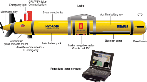
    remus-600-specifications-500x281
    The Remus 600 Unmanned Underwater Vehicle, made by Kongsberg Maritime, a Norwegian company.

    The U.S. Navy plans to deploy its first underwater drones from submarines later this year, according to a report by Military.com.

    The website quoted Rear Adm. Joseph Tofalo, the Navy’s director of undersea warfare, who said the deployment will include the use of the Remus 600 Unmanned Underwater Vehicles (UUVs) to perform undersea missions around the globe.

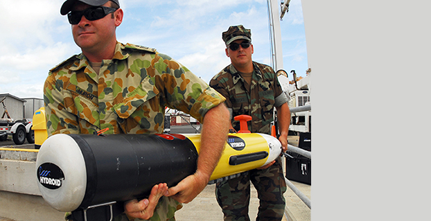
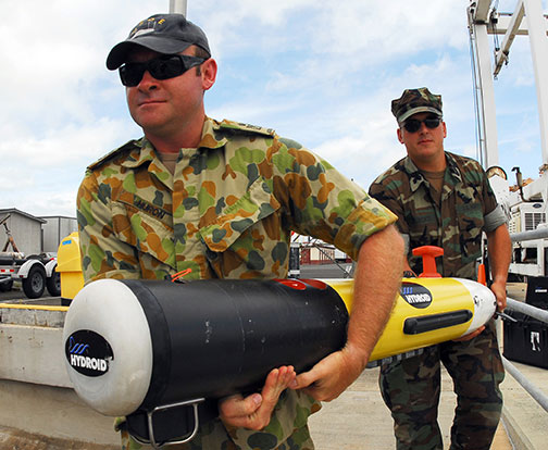
    Sailors carry a Remote Environmental Measuring Unit (REMUS) 100. (Credit: U.S. Navy)
    Sailors carry a Remote Environmental Measuring Unit (REMUS) 100. (Credit: U.S. Navy)

    “Now you are talking about a submarine CO who can essentially be in two places at the same time — with a UUV out deployed which can do dull, dirty and dangerous type missions. This allows the submarine to be doing something else at the same time,” Tofalo said. “UUVs can help us better meet our combatant command demand signal. Right now, we only meet about two-thirds of our combatant commanders’ demand signals, and having unmanned systems is a huge force multiplier.”

    The Remus 600 is a 500-pound, 3.25-meter-long UUV equipped with GPS, as well as dual-frequency side-scanning sonar technology, synthetic aperture sonar, acoustic imaging, and video cameras manufactured by Hyrdoid, a subsidiary of Kongsberg Maritime. The Remus 600 is similar to Bluefin Robotics UUVs, which were used to search for wreckage of missing Malaysia Airlines flight MH370. Other applications include hydrographic surveys, harbor security, and environmental monitoring.

    In this video, Explosive Ordnance Disposal Mobile Unit One (EODMU-1) tests the Remus 600 to locate mines using autonomous guidance and advanced sonar.


  • AUVSI Unmanned Systems Offers Demonstrations, Exhibits

    The Association for Unmanned Vehicle Systems International (AUVSI) will host Unmanned Systems 2015, which will run from May 4-7 at the Georgia World Congress Center Atlanta. With 8,000 attendees from around the world, Unmanned Systems 2015 is the largest expo and trade show in the industry, according to AUVSI.

    The event will include three days of interactive exhibits and exciting demonstrations of air and ground vehicles spread throughout 350,000 square feet of exhibit space. The 150-plus educational sessions, workshops, and panel presentations will focus on the future of commercial, humanitarian, environmental, governmental, and military applications for robotics and unmanned systems. For more information on the sessions, see AUVSI’s Program Planner

    This year’s conference will feature keynote addresses and panel discussions by:

    • Colin Guinn, chief robotics officer, 3D Robotics
    • Dave Vos, project lead, Project Wing @ GoogleX
    • David Vigilante, senior vice president, legal, CNN
    • Helen Greiner, CEO, CyPhy Works
    • Hugh Herr, MIT professor and head of biomechatroinics at the MIT Media Lab
    • Rep. Frank Lobiondo, New Jersey House of Representatives 
    • Henrik I. Christensen, distinguished professor, KUKA chair of Robotics, and director of the Robotics & Intelligent Machines Center, Georgia Tech

    For more information and a full agenda of events, visit www.auvsishow.org.

  • Fifth Galileo Colloquium Planned for October

    Fifth Galileo Colloquium Planned for October

    Galileo satellite signals. (Image credit: ESA)
    Galileo satellite signals. (Image credit: ESA)

    The fifth International Colloquium on Scientific and Fundamental Aspects of the Galileo Programme will be held in Braunschweig, Germany, Oct. 27–29.

    Since 2007, the worldwide scientific community has met every two years to discuss the scientific possibilities of Galileo and other Global Navigation Satellite Systems (GNSS).

    This colloquium will bring together members of the European scientific community and their international partners involved in the use of GNSS signals in their research, specifically Galileo signals. Major academic players will meet with institutional and industrial executives to share innovative ideas and influence the future evolution of Europe’s own GNSS.

    The colloquium focuses on four major areas of research:

    • Scientific applications in meteorology, geodesy, geophysics, space physics, oceanography, land surface and ecosystem studies, using either direct or reflected signals, differential measurements, phase measurements, radio occultation measurements, using receivers placed on the ground, in aircraft or on satellites.
    • Scientific developments in physics, dealing with future GNSS, particularly in testing fundamental laws in astronomy and in quantum communication. Relativistic reference frames and relativistic positioning will be addressed — also taking into account the scientific opportunities in tracking the first two Galileo Full Operational Capability satellites in their elliptical orbits.
    • Aspects of metrology such as reference frames, onboard and ground clocks, and precise orbit determination.
    • Scientific aspects of satellite navigation and positioning such as signal propagation, tropospheric and ionospheric corrections and the means to model and mitigate multipaths and interference.

    The various possibilities to use navigation satellites such as Galileo for scientific purposes will be reviewed, and the contribution of scientific applications to making the most of the present systems and defining their evolution will be scrutinized.

    For those interested in submitting papers, online submission of abstracts opens May 15 through the colloquium website, where other details of the event can also be found.

  • Telit GNSS Module Enables High-Performance Position Reporting

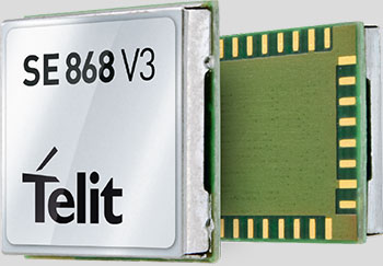
    Telit's Jupiter SE868-V3 module.
    Telit’s Jupiter SE868-V3 module.

    Telit Wireless Solutions has released a new GNSS module, the SE868-V3. The positioning module combines GPS, GLONASS, Beidou, Galileo and SBAS, which enables the creation of high-performance position reporting and navigation solutions.

    The SE868-V3 can navigate to -162 dBm and track to -166 dBm, providing improved performance in harsh environments. It is pin-to-pin compatible with the former SE868-V2 as well as the JF2. This advanced GNSS module can track GPS and GLONASS or GPS and Beidou constellations simultaneously and it is Galileo-ready.

    The 11 x 11 mm QFN package contains a powerful baseband processor, SQI Flash memory and GNSS chip with integrated low noise amplifier (LNA). The ultra-sensitive RF front-end enables multi-GNSS indoor fix and high-quality navigation in challenging outdoor scenarios such as dense urban areas, Telit said.

    In addition, the SE868-V3 supports ephemeris file injection (A-GPS) as well as Satellite-Based Augmentation System (SBAS) to increase position accuracy. Its onboard software engine is able to locally predict short-term ephemeris starting from data broadcast by GNSS satellites received by the module and stored in the internal Flash memory.

    “The SE868-V3 is yet another addition to our positioning product portfolio, which is the result of over 20 years of experience in GNSS applications,” said Felix Marchal, chief product officer, Telit. “Our products are compatible with the GPS constellation as well as its Russian counterpart GLONASS and China’s Beidou.”