Author: GPS World Staff

  • Russian Company Credo-Dialogue Releases GNSS Software

    The Russian company Credo-Dialogue has released Credo GNSS 1.0, a GNSS processing software.

    Credo GNSS 1.0 is designed for processing of satellite geodetic measurements in differential mode. In this mode, the simultaneous operation of two or more receivers forms the baseline.

    The input can use the following types of data:

    • satellite geodetic measurements and ephemeris format RINEX (2.0-3.2);
    • satellite geodetic measurements and ephemeris formats satellite geodetic receivers (in accordance with the import module);
    • import point coordinates from text files in any format, user-configurable;
    • precise ephemeris (can be downloaded automatically to the time span of the project); and
    • raster image formats BMP, GIF, TIFF (GeoTIFF), JPEG, JPEG2000, PNG, CRF, ECW and RSW.

    Also in the program, users can view images from web services such as Google Maps, Bing and Express Kosmosnimki.

    Credo GNSS supports a variety of coordinate systems, including Transverse Mercator, Mercator, PseudoMercator, Lambert Conformal Conic and Orthographic.

    To learn more about the software, click here or view the video below.

    https://www.youtube.com/watch?v=zRmTB4GEhak

  • EGNOS-Africa Joint Programme Office Launched

    The SAFIR (Satellite navigation services for AFrIcan Region) project has officially launched the EGNOS-Africa Joint Programme Office, laying the first stone of its future office building in a ceremony in Dakar, Senegal.

    SAFIR is part of the Africa-EU long-term strategic partnership to enhance safety in air transport. Its global objective is to build capacity within African ACP countries for the future deployment of GNSS/EGNOS in the region. The three-year project is funded by the European Union and financed from the 10th EDF Intra ACP envelope with 3.7 million euros, under an international consortium led by ASECNA (Agence pour la Sécurité de la Navigation Aérienne en Afrique et à Madagascar) with Egis, Pildo Labs and ESSP.

    The ceremony took place in Dakar on March 3. Those attending included Matthias Petschke, EU Satellite Navigation Programmes director; Karolina Stasiak from the UE Delegation in Sénégal; and Amadou Ousmane Guittèye, director general of ASECNA.

    “Satellite navigation can bring huge societal benefits, be it in transport, in agriculture or land management,” Petschke said in remarks at the launch ceremony. “Satellite-based augmentation systems in particular, like EGNOS, can bring enormous social and economic benefits. I attach, therefore, great importance to the setting up of the EGNOS Africa Joint Programme Office and am particularly pleased to see this team of African experts who have extensive experience and knowledge to support the development of an African satellite based augmentation system.”

    In his speech, Guittèye said, “The first mission of the JPO is to ensure Africa has developed adequate competencies and then to coordinate the implementation of the development and of the deployment of GNSS/EGNOS services and applications in the continent. The EGNOS-Africa Joint Programme Office (JPO) is a pan-African entity that acts for the benefit of Africa and supports stakeholders in their GNSS/EGNOS strategy, developments and implementation.”

    The ceremony also was attended by officials from the International Civil Aviation Organisation (ICAO), the African Civil Aviation Commission (AFCAC), the Agence Nationale de l’Aviation Civile et de la Météorologie (ANACIM) , the Aéroports du Sénégal (ADS) and local authorities.

    The SAFIR project began on January 15, 2013. It covers the set-up, staffing and operations of an EGNOS-Africa Joint Programme Office, and sets up and supports a number of technical working sessions composed of regional stakeholders concerned with GNSS/EGNOS in sub-Saharan Africa.

    ASECNA has 18 member states. With air navigation safety as its main mission, it cooperatively manages African airspace for the countries of Benin, Burkina Faso, Cameroun, Central African Republic, Comoros, Congo, Côte d’Ivoire, France, Gabon, Guinea Bissau, Equatorial Guinea , Madagascar, Mali, Mauritania, Niger, Senegal, Chad and Togo.
  • GPS IIF-9 Prepped for March 25 Launch

    GPS IIF-9 Prepped for March 25 Launch

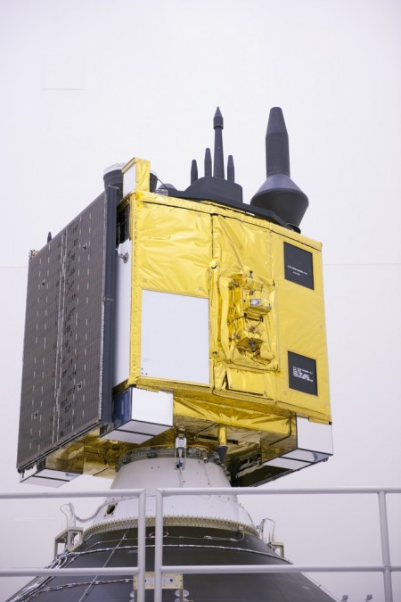
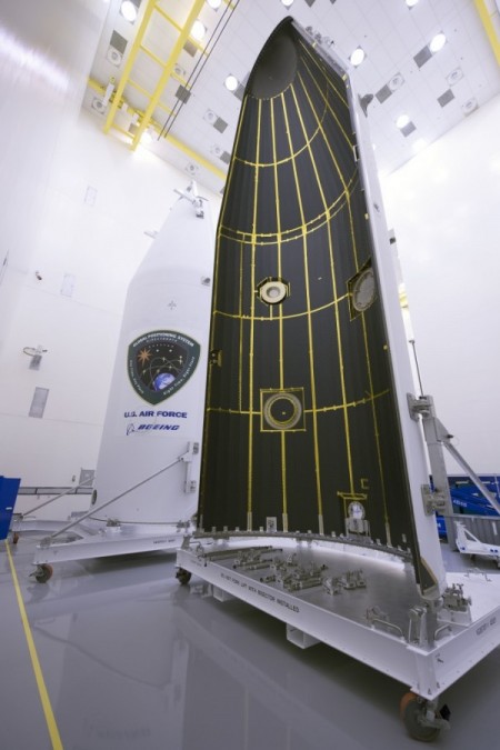
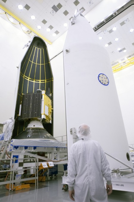
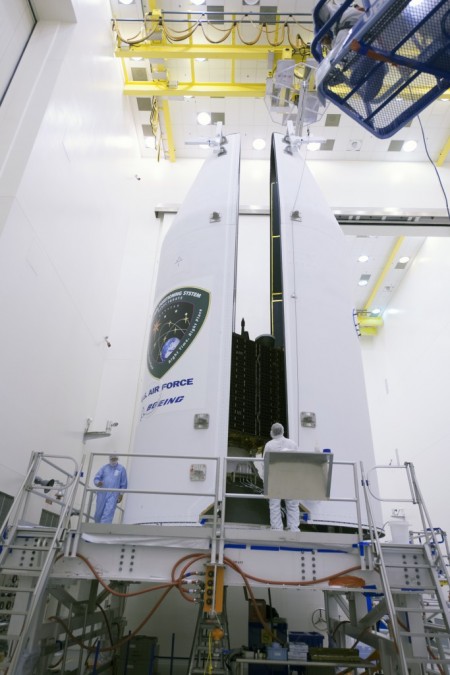
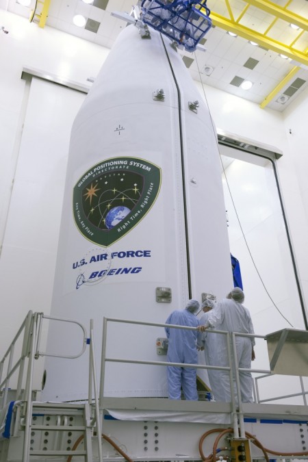
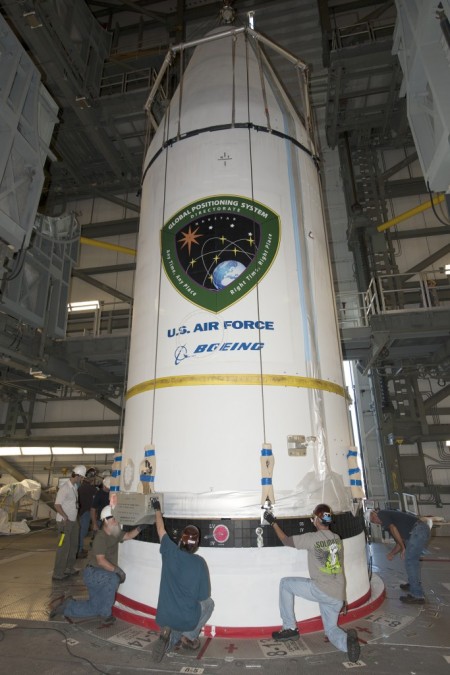
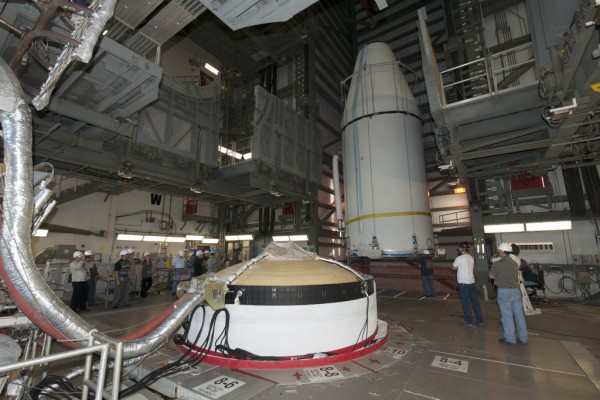
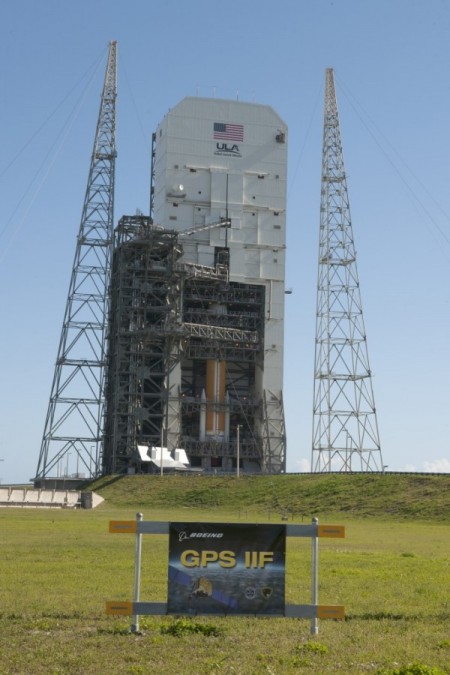
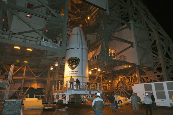
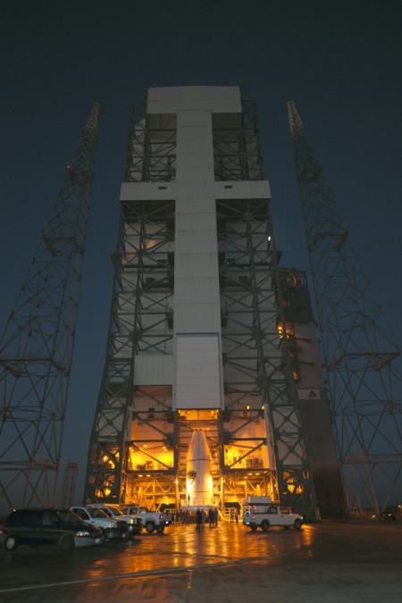
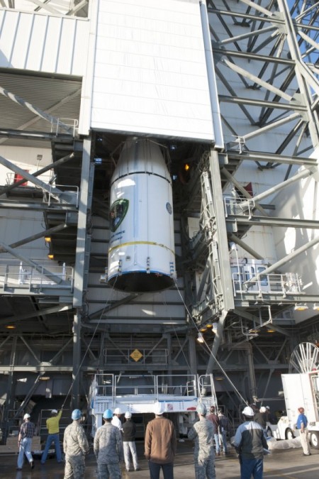
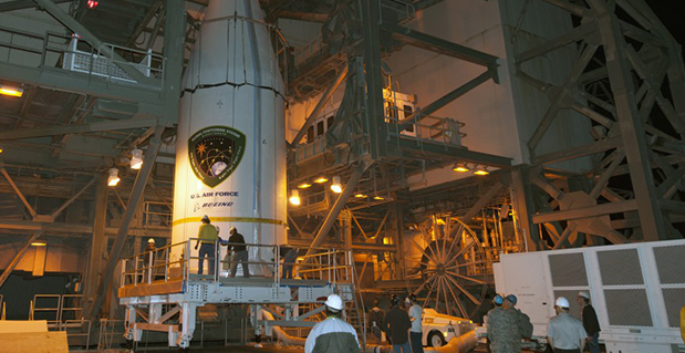
    The U.S. Air Force’s ninth GPS Block IIF satellite (GPS IIF-9) has been encapsulated in the Delta IV rocket’s four-meter-diameter nose cone at a processing facility, and moved to the launch pad at Space Launch Complex 37 for mating to its booster inside the mobile service tower.

    Launch is scheduled for March 25 at 2:36 p.m. EDT (1836 GMT) from Space Launch Complex 37 at Cape Canaveral Air Force Station, Fla. GPS IIF-9 marks the 29th Delta IV launch and the 57th operational GPS satellite to launch on a ULA or heritage launch vehicle.

    To follow the launch countdown, dial the ULA launch hotline at 1-877-852-4321 or join the conversation on Facebook, Twitter or Instagram.

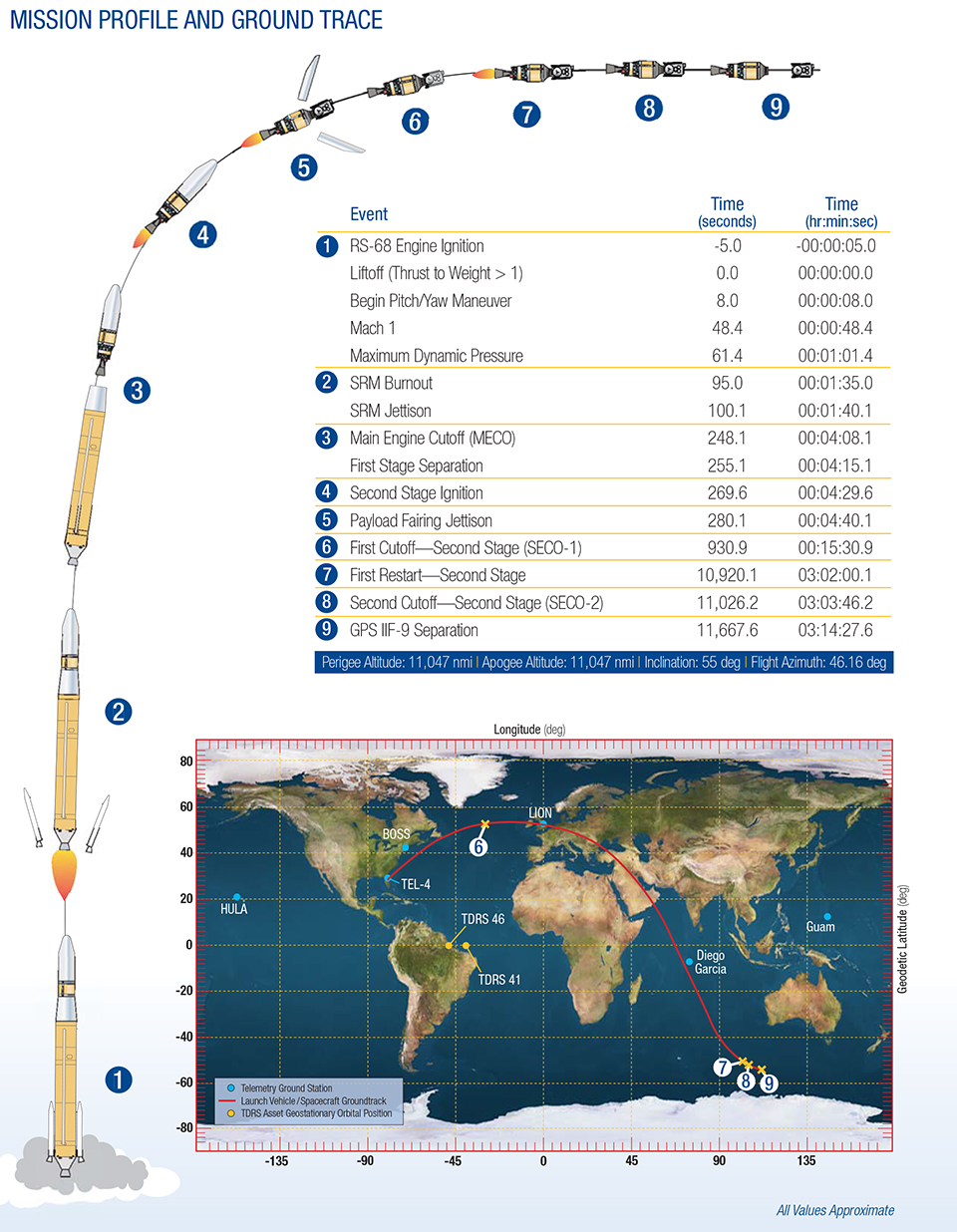
    GPS IIF-9 Mission profile and ground trace. (courtesy of ULA)
    The planned GPS IIF-9 launch trajectory, event times, and ground trace. (courtesy of ULA)

    Below are photos from the United Launch Alliance, which supplies the Delta IV rocket and serves as the launch provider for the GPS Directorate.


  • Galileo 6 Signals Acquired

    News courtesy of CANSPACE Listserv.

    On March 17, some stations participating in the International GNSS Service Multi-GNSS Experiment acquired E1 and E5a signals from Galileo 6 (FOC-FM2, GSAT0202). The satellite is using pseudorandom noise code E14.

    The orbit of Galileo 6 was recently adjusted to make it more circular with a higher perigee after it was launched into an incorrect orbit last August.

  • Galileo 7 and 8 Fitted to Dispenser in Preparation for Launch

    Galileo 7 and 8 Fitted to Dispenser in Preparation for Launch

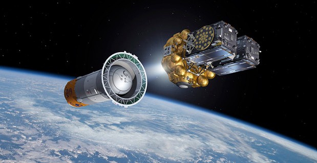
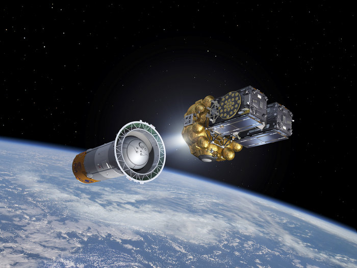
    Artist's view of Galileo satellites attached to their dispenser atop their Fregat upper stage separating from the Soyuz upper stage. The Fregat then flies them the rest of the way up to medium-Earth orbit.  (courtesy of ESA)
    Artist’s view of Galileo satellites attached to their dispenser atop their Fregat upper stage separating from the Soyuz upper stage. The Fregat then flies them the rest of the way up to medium-Earth orbit. (courtesy of ESA)

    News courtesy of the European Space Agency

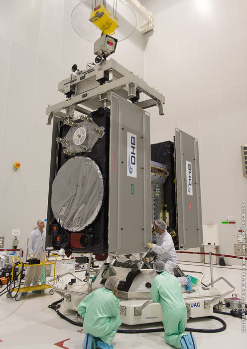
    The seventh and eighth Galileo satellites being fitted together onto the dispenser, March 16-17. (Photo courtesy of ESA)
    The seventh and eighth Galileo satellites being fitted together onto the dispenser, March 16-17. (Photo courtesy of ESA)

    The seventh and eighth Galileo satellites, set for launch together in nine days’ time, have been fitted together onto the dispenser that will carry them during their flight to orbit.

    The fueling of the two satellites was completed last week, leaving them ready to be placed into launch configuration. They were carefully lowered into place then attached to the dispenser. The operation went smoothly, the two satellites having previously gone through separate “fit checks” with the dispenser in advance of fueling.

    The specially designed carrier will hold the satellites in place during their four-hour flight into orbit some 22,300 km above our planet. Then, at the correct altitude, the two satellites are sprung away in opposing directions. Next, the dispenser plus satellites will be placed onto the Fregat upper stage of their Soyuz ST-B launcher.

    As much a spacecraft as a launch stage, the reignitable Fregat will haul the Galileo satellites most of the way up to their final orbital altitude, once the first three stages of the Soyuz have taken them up to their initial orbit.

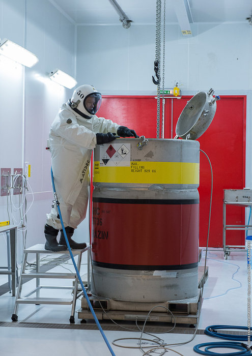
    Fuel for the seventh and eighth Galileo satellites, checked by an engineer in a protective SCAPE (Self Contained Atmospheric Protective Ensemble). Fuelling of the two satellites took place at the end of the second week of March 2015, allowing the satellites to be fitted to their launch dispenser ahead of the March 27 launch. (Photo courtesy of ESA)
    Fuel for the satellites is checked by an engineer in a protective SCAPE (Self Contained Atmospheric Protective Ensemble). (Photo courtesy of ESA)

    Note the protective metal panels covering the solar wings folded against the sides of the Galileo satellites. Protecting these delicate solar arrays during handling on the ground, these panels will be removed ahead of launch.

    The launch of the seventh and eighth Galileo satellites is scheduled for March 27.

  • Ride Service Uber Acquires Mapping Company DeCarta

    Ride service Uber is buying mapping and search startup deCarta, reports Mashable, which said it learned of the deal from an Uber representative.

    The deal was expected to close earlier this month. Uber plans to use deCarta’s technology and talent to fine-tune its products and services that rely on maps, including UberPOOL, the smartphone-based ride-sharing app.

    Thirty out of 40 deCarta employees will remain with the company, including Kim Fennell, chief executive officer and president, Mashable said. deCarta will continue to operate as a wholly-owned subsidiary of Uber, but will use its own name.

    Founded in 1996, deCarta is privately held, and headquartered in San Jose, Calif., with international offices and distributors in Germany, China, Brazil and South Africa. deCarta is a global location-based services (LBS) technology company that provides specialized geospatial technologies for online mapping, routing, navigation, geocoding, local search and geo-data integration and processing. The company’s platform is used by high-volume LBS applications and services in the mobile, Internet, enterprise-fleet and automotive markets.  Customers and technology partners include Samsung, Inrix, T-Mobile, FullPower MotionX GPS Drive, Appello, Denso, Ford, GM OnStar, Masternaut, Wireless Matrix, eMapgo, Nokia/HERE, Spot-On-Time, Telstra/Sensis, TomTom, WHERE/eBay.

    In February, Uber announced a partnership with Starwood Hotel and Resorts where Starwood Preferred Guest members earn points towards free hotel stays for every dollar spent riding Uber.


  • Esri and RouteSmart Help Postal Carriers Reduce Operating Costs

    Esri and RouteSmart Technologies, Inc., are collaborating to help postal organizations deliver packages reliably, efficiently, and accurately. The companies provide comprehensive dynamic routing solutions based on Esri’s ArcGIS platform.

    National postal and global and regional parcel delivery services, including Whistl, Posti, and Swiss Post, are among the customers that leverage these routing solutions. Most customers have experienced cost savings of 15 percent, on average, through reduced working hours, mileage, and new vehicle acquisition. Customers also report growth opportunities through opening new lines of distribution business to support the burgeoning e-commerce delivery segment.

    “By integrating location-based analysis with a postal organization’s traditional business systems, such as sorting machines and address management systems, we are solving territory planning and route management challenges these organizations are facing,” said Chris Walz, vice president of sales and marketing for RouteSmart Technologies. “With our help, they can align to the new realities of postal and parcel distribution economics brought on through the growth of e-commerce shipping volumes and declining letter volumes.”

    Esri and RouteSmart will share how they are helping postal organizations continue to be drivers of innovation in transportation and operational efficiencies at the European Post and Parcel Services Conference in Vienna, Austria, March 24–26.

    “One of the biggest upcoming challenges for the postal industry will be the adoption of fully automated vehicles for deliveries,” Hall said. “With our partner RouteSmart, we provide a path for migration with the help of advanced location intelligence, optimization, and analysis tools.”

  • Solar Storm Hits Earth’s Magnetic Field

    Solar Storm Hits Earth’s Magnetic Field

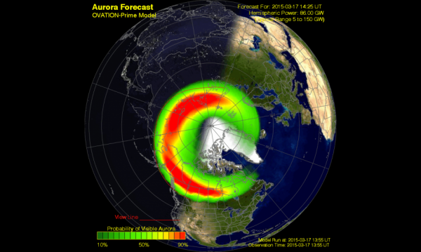
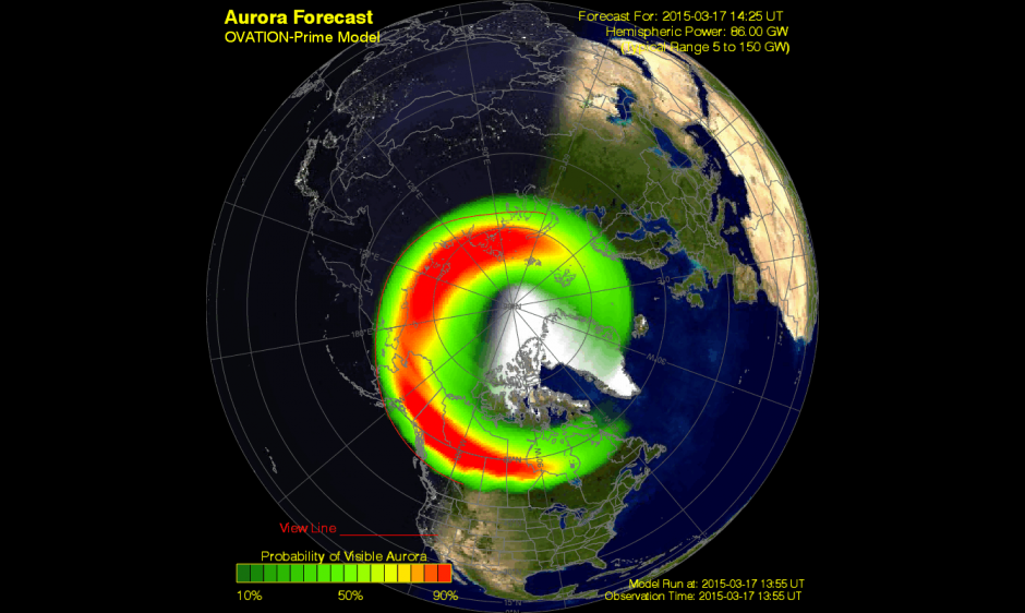
    A G4 (Severe) geomagnetic storm was observed today at 07/1358 UTC (09:58 am EDT). This is the response to a pair of CMEs observed leaving the Sun on 15 March. Shown here is a model depiction of where the aurora is likely visible. Storm conditions are forecast to persist for the next several hours before beginning to wane down towards the end of the UT day. (Courtesy of NOAA)
    A G4 (Severe) geomagnetic storm was observed today at 07/1358 UTC (09:58 a.m. EDT). This is the response to a pair of CMEs observed leaving the Sun on March 15. Shown here is a model depiction of where the aurora is likely visible. Storm conditions are forecast to persist for the next several hours before beginning to wane down towards the end of the UT day. (Courtesy of NOAA)

    A G4 (severe) geomagnetic storm is now taking place, the most powerful solar storm of the current solar cycle, reports Discovery.com.

    Initially triggered by the impact of a coronal mass ejection (CME) hitting our planet’s magnetosphere, a relatively mild geomagnetic storm erupted at around 04:30 UT (12:30 a.m. EDT), but it has since become a severe G4-class geomagnetic storm. Bright auroras were sighted over several northern-tier U.S. states including Minnesota, Wisconsin, Montana, the Dakotas and Washington. The storm could continue for many hours as Earth passes through the turbulent wake of the CME.

    Storm conditions are forecast to persist for the next several hours before beginning to wane down towards the end of the UT day.

    Not all types of solar activity (sun spots, solar flares, solar burst, and solar radiation) affect GPS receiver operations. Geomagnetic storms, however, can cause problems for GPS receivers if the storms are powerful enough.

    The solar cycle is about 11 years long, during which the sun waxes and wanes in magnetic activity.

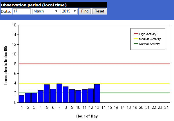
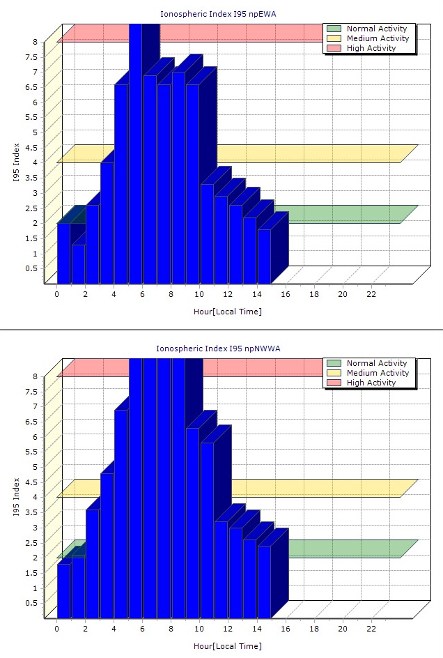
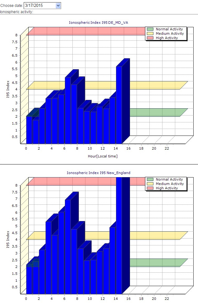
    Below are ionospheric charts from Missouri, Washington State and New England.

    Missouri ionosphere chart during the March 17 geomagnetic storm.
    Missouri ionosphere chart during the March 17 geomagnetic storm.
    Washington ionosphere chart
    Washington ionosphere chart during the March 17 geomagnetic storm.
    New England ionosphere chart during the March 17 geomagnetic storm.
    New England ionosphere chart during the March 17 geomagnetic storm.
  • Moscow Navigation Forum to Focus on GLONASS Market

    announcement
    Credit: Navitech

    The International Navigation Forum is a central event of year in the field of the commercial use of satellite navigation technologies — especially of the Russian navigation system GLONASS. The forum will be held April 22-23 at the Expocentre Fairgrounds in Moscow, in conjunction with the 7th International Exhibition on Navigation Systems, Technologies and Services (Navitech), which takes place April 22-24.

    The forum is designed to inform Russian and foreign audiences about state policies in the development and application of GLONASS technology in Russia and worldwide. It also aims to analyze the latest trends of the navigation industry, as well as to discuss the product and service market for various consumers and conditions for its export to foreign markets.

    The Navitech 2015 exhibition is aimed at world leaders in satellite navigation, as well as information technologies, geodesy and cartography. Navitech 2015 unites leading Russian and foreign developers and manufacturers of navigation equipment, services and software, including mapping apps. It reflects current world trends and serves as a main exhibition event for industry specialists. The Navitech Exhibition is the only specialized satellite navigation exhibition in Russia.

    The agenda of the 9th International Navigation Forum is designed for the end-user of navigation products and services, and highlights all aspects of their practical use for building a successful business and enhancing its efficiency.

    Forum attendees will receive detailed information about legal aspects of using satellite navigation, be introduced to navigation and communication equipment of leading Russian and foreign manufacturers, and learn about different industry applications and leading companies’ experiences in the practical use of navigation technologies, including business cases of using satellite navigation by Russian business representatives.

    Sessions and roundtables will present the most current information about developed products and important issues in the fields of navigation, mapping, and legal regulation. The participants will be able to give their suggestions on creating favorable conditions for the effective introduction of innovative technologies and exchange experiences.

    Forum topics:

    • Status and development prospects of GLONASS and foreign navigation satellite systems
    • Major development trends of the Russian market of navigation services and equipment
    • Practical experience of using satellite navigation technologies in different sectors of the Russian economy
    • Navigation technologies for intellectual transport systems
    • Information and navigation services, systems and equipment for mass market
    • Navigation technologies for passenger transport
    • Navigation and communication equipment of leading Russian and foreign manufacturers
    • Geoinformation systems for various purposes

    Exhibition topics:

    • In-vehicle navigation and information systems
    • Navigation technologies for land development, survey, design and construction
    • Automotive and personal navigation, equipment, LBS
    • Professional navigation equipment, modules and components

    To learn more, visit the websites: www.glonass-forum.com and www.navitech-expo.ru/en/. To participate as a delegate, speaker, sponsor or a partner, contact ProConferences by phone + 7 (495) 641 57 17 or email [email protected]


  • Counting Down to Galileo

    Galileo 7 and 8 launch on March 27. The Galileo satellite navigation system remains on track after successful in-orbit validation and the salvage for navigational testing of two satellites launched into an incorrect orbit. The mini-constellation of satellites in orbit plus their associated ground segment has allowed in-depth testing of the overall Galileo system, and the performance was good. Now with the launch of the latest pair of satellites, ESA and the European Commission are progressing with the deployment phase of the program.

  • New app for farmers enables smartphone nav in the field

    New app for farmers enables smartphone nav in the field

    Agribus-NAVI
    Photo: Agribus-NAVI

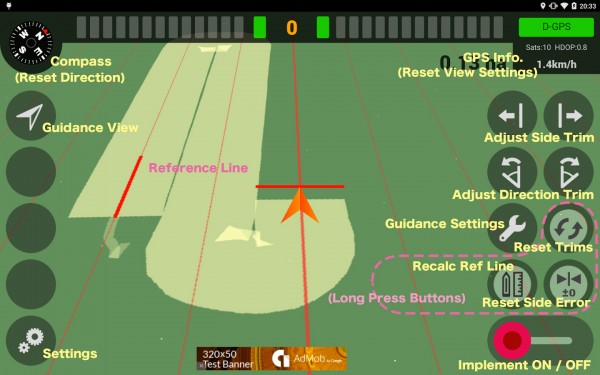
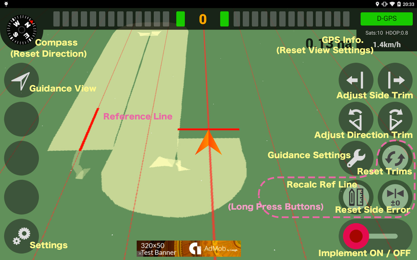
    A new app available on the Google Play store enables farmers to use their smartphone in the field.

    AgriBus-NAVI is a GPS guidance system to mount on agricultural machinery such as tractors, combines and self-propelled sprayers to help with straight-line tasks in the field. Checking the display while driving will enable the creation of straight and evenly spaced lines in large fields.

    The app, which is compatible with Android 4.0 and above smartphones and tablets, doesn’t offer the automatic steering functionality that dedicated precision agriculture GPS devices usually do.

    The app, by Agri Info Design, is based on the software “Agricultural Vehicle Navigation Software for Field Operation” and a patent “JP-4572417-B2” developed by National Agricultural Research Organization (NARO).

  • New Report Considers GNSS Market Outlook 2015-2020

    Research and Markets has added the report “Global Navigation Satellite Systems Market Outlook 2020” to its offerings. The global core GNSS market is forecast to grow at a CAGR of 9 percent during 2015-2020.

    In the report, the analysts have identified and deciphered the market dynamics in important GNSS industry segments, highlighting the areas offering promising possibilities for companies to boost their growth, according to Research and Markets. The report studies the market by sectors including location-based services (LBS), transportation (further divided into road navigation, rail navigation, air navigation and marine navigation), surveying and agriculture. The GNSS application market is further studied by region: North America, Europe, Asia-Pacific, and Rest of World.

    The report provides a complete overview of the GNSS market globally. All the current trends and drivers, coupled with potential growth areas of the GNSS industry, have been evaluated in the report. Furthermore, the report provides information on opportunities in the industry for different companies in the chapter titled Opportunity Assessment.

    Additionally, to provide an exhaustive knowledge of the prospects for GNSS players on the geographical front, the report provides comprehensive knowledge of the 10 most worthwhile GNSS markets around the world (U.S., Canada, UK, France, Germany, RussiaJapan, China, South Korea and India). It includes information about the present state and future outlook of the LBS and telematics markets in these countries along with information about their personal navigation systems such as GPS, BeiDou,Galileo, GLONASS, QZSS and IRNSS.

    The report also looks into the competitive landscape covering business overviews, key financials, product analyses, recent developments and strengths and weaknesses of each of the players.

    Key trends considered in the report include:

    • Driverless Car: New GNSS Technology Use
    • Indoor GNSS Positioning Poised for Growth
    • People, Pets and Thing Finder: The Next Attraction
    • GNSS Based Products: A Burgeoning Market Opportunity
    • GNSS Jamming Gaining Attention

    Companies mentioned include:

    • AgJunction
    • CSR
    • Furuno Electric Co Ltd.
    • Garmin Ltd.
    • MiTAC International Corp.
    • Raytheon Company
    • Rockwell Collins
    • TomTom NV
    • Topcon Corporation
    • Trimble Navigation Ltd.