Author: GPS World Staff

  • Air Force Working on Glitch for GPS IIF Satellites

    The U.S. Air Force is working to resolve a technical error that affected some Boeing GPS satellites, according to a report by Reuters.

    The error does not affect the accuracy of GPS signals. It involves the ground-based software used to index some messages transmitted by GPS IIF satellites built by Boeing, Air Force Space Command said according to Reuters. Still, officials are investigating other possible causes.

    Lockheed Martin runs the GPS ground control segment, which enables Air Force officials to operate all GPS satellites, including the IIF satellites built by Boeing.

    Air Force Space Command Public Affairs released the following statement:

    “A GPS message indexing issue was recently identified that affects a limited number of active GPS IIF satellites, but does not degrade the accuracy of the GPS signal received by users around the globe. The result is an occasional broadcast not in accordance with U.S. technical specifications. The issue appears to be related to the ground software that builds and uploads messages transmitted by the GPS constellation during regular system operations, although the Air Force continues to investigate all possible causes.

    “Although the issue was brought to light in the last few days, a close examination of archived GPS message data reveals that the message indexing error has gone unnoticed since 2013. Air Force Space Command has implemented a workaround to prevent further message indexing violations and is taking steps to permanently correct the error.”

    The U.S. Air Force will be launching the ninth Boeing Block IIF satellite on Wednesday.

  • IGN France International to Update Congo’s Roadway Database

    Photo credit: © Vincent LECAMUS/ IGN FI
    Photo credit: © Vincent LECAMUS/ IGN FI

    A contract between the Congolese Ministry of Roads and Public Works and IGN France International for a preliminary study on updating the country’s existing roadways database was signed on Jan. 12 at the Congolese Embassy in France.

    Once this database is fully operational it will be used as a decision-making tool for the Ministry and various institutions in charge of road network maintenance, as well enabling the management of Congo’s road heritage.

    IGN France International will carry out a preliminary study for the Ministry, which aims to update the existing roadways database for the whole of the country.

    Among those present at the signing of the contact was a large Congolese delegation led by the Ministry of Roads and Public Works Minister, Emile Ouosso.

    Photo credit: ©Aude ARESTE-LAMENDOUR / IGN FI
    Photo credit: ©Aude ARESTE-LAMENDOUR / IGN FI

    This project is the next phase of an overall program of large-scale works undertaken by the Congolese government since 2009, which have already included the extension and improvement of the country’s road network, which no longer resembles the map created by IGN — French National Institute for Geographic and Forest Information — in 1993.

    The preliminary study will define:

    • the expected functionalities of the future database;
    • the status of reference data;
    • the status of various “trades;”
    • the general organization to be implemented for the effective update of the database;
    • the equipment required for data acquisition, treatment and conservation;
    • and the knowledge transfer to be provided in order that work can be carried out locally.

    This database will constitute a road heritage management and decision-making tool for the Ministry.

    At present, the National Transport program (PNT) adopted by the Parliament of Congo in 2007 remains the general framework governing the actions to be taken in terms of the construction, rehabilitation or maintenance work on roadway infrastructures includes in the societal program created by the President of the Republic.

  • Geofeedia, IDV Form Partnership for Threat Assessment

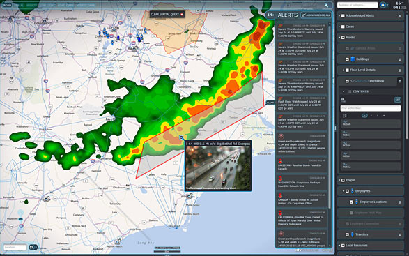
    idvsolutions_visual_command_center Photo: IDV Solutions
    IDV Solutions’ Visual Command Center is a physical security and risk visualization (PSRV) software that unites data from external sources, enterprise systems and internal devices into a real-time, common operating picture of risk and security. Photo: IDV Solutions

    IDV Solutions, a corporation that specializes in business intelligence, physical security and risk visualization software, has formed a technical partnership with Geofeedia, producer of a cloud-based social media monitoring platform. Through the partnership, Geofeedia’s location-based social media monitoring data will now be integrated into IDV Solutions’ Visual Command Center Enterprise Risk Visualization (ERV) software.

    The companies say the combination of the two technologies enables security, supply chain and business continuity teams to gain instant intelligence from multiple social media networks for a myriad of risk events — from a political demonstration to a natural disaster. The location-based visualization filters out excess noise to show important social media posts in the context of locations of interest, such as facilities, employee locations, supply routes or traveling executives.

    “Companies are looking for ways to efficiently gain actionable intelligence from social media,” said Ian Clemens, chief technology officer and co-founder of IDV Solutions. “The immediacy of social media combined with the alerting and locational context offered by Visual Command Center enables organizations to make more effective use of social media to protect employees, facilities and business continuity.”

    The Visual Command Center provides a real-time, common operating picture of assets, personnel and operations in relation to potential threats to those assets. It unites information on global sources of risk — such as weather, terrorism and natural disasters — with data from internal data stores and physical security systems on an interactive map and timeline. When a risk is detected near an asset or employee location, the Visual Command Center automatically generates an alert and provides tools to assess whether the risk is a threat and take immediate action to mitigate the impact of the threat.

    The Geofeedia integration complements the Visual Command Center’s Twitter Visualization and Alerting Module by providing information from more social media networks and visualizing all posts within a selected area.

    Geofeedia enables organizations to filter and analyze social media content by location in real time across multiple sources. Users search for a city, address or location name, draw a virtual perimeter around the specific area of interest,and access geo-tagged social media content from within those boundaries.

    “Location resolves the challenge of monitoring the massive amounts of cluttered data to identify meaningful, real-time on-the-ground intelligence when and where it matters most,” said Phil Harris, CEO and co-founder of Geofeedia. “We are thrilled to be able to help more organizations take advantage of our real-time, geotagged social media data to prevent, protect and respond to valuable intelligence.”

  • GEO Business 2015 Returns for Second Year

    geo_business2015_logo_TFollowing its debut in 2014, GEO Business returns to The Business Design Centre in London on May 27-28.

    GEO Business 2015 combines a central trade exhibition with a conference program with 50 presentations and 140 live commercial workshops.

    The presentations and workshops, which provide first-hand demonstrations, have grown in number by 34 percent over the first year. Also larger this year is the exhibit space, by 64 percent, organizers said. The exhibit features more than 200 exhibitors showcasing the latest geospatial technology and services.

    The show’s unifying vision is to promote closer collaboration across the geospatial community and to provide a platform that effectively showcases both the professionalism of this industry and the role that it will play in future economic growth. It was born out of consultation with industry and as a result is organized in collaboration with the Chartered Institution of Civil Engineering Surveyors (ICES), the Royal Institution of Chartered Surveyors (RICS), The Survey Association (TSA), the Association for Geographic Information (AGI) and more recently the Institution of Civil Engineers (ICE).

    In 2014, more than 1,600 attendees from 39 countries took part. Learn more at the conference website.

  • FAA Gives Amazon Go-Ahead for Delivery Drone Tests

    Amazon-drone-O

    The Federal Aviation Administration has issued an experimental airworthiness certificate to an Amazon Logistics, Inc. unmanned aircraft (UAS) design that Amazon will use for research and development and crew training. Amazon has said it wants to use drones for delivering packages to customers.

    The FAA typically issues experimental certificates to manufacturers and technology developers to operate a UAS that does not have a type certificate.

    Under the provisions of the certificate, all flight operations must be conducted at 400 feet or below during daylight hours in visual meteorological conditions. The UAS must always remain within visual line-of-sight of the pilot and observer. The pilot actually flying the aircraft must have at least a private pilot’s certificate and current medical certification.

    The certificate also requires Amazon to provide monthly data to the FAA. The company must report the number of flights conducted, pilot duty time per flight, unusual hardware or software malfunctions, any deviations from air traffic controllers’ instructions, and any unintended loss of communication links. The FAA includes these reporting requirements in all UAS experimental airworthiness certificates.


  • Navitel Offers Navigation Map of India

    Navitel Offers Navigation Map of India

    Navitel_India
    Photo: Navitel

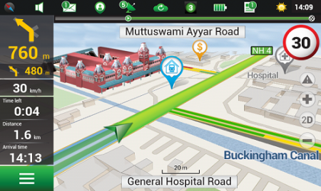
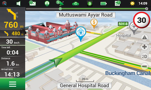
    Navitel’s navigation map of India is now available for purchase, for use with the Navitel Navigator GPS & Maps app on Google Play. Navitel Navigator is a precise offline GPS navigation with free geosocial services and detailed maps of 59 countries, with 20 million downloads worldwide.

    The map of India contains 2,092,013 km of road graph, 594 627 cities, towns, and other settlements, as well as 5,294,344 POI. Coupled with the address search in more than 6 000 residential and industrial areas of settlements, this map includes the detailed housing system data with due account for the number of floors, detailed road networks with all streets, roads, and indicated traffic direction, road interchanges, roundabouts, and other important road information.

    The map contains 149 3D points of interest, including:

    • Delhi – Akshardham Temple, Qutub Minar, Laxmi Narayan Mandir, and Lotus Temple.
    • Gujarat – ISCON Mall, Satyam Centre, the Metropole Hotel, Kaizen Hospital.
    • Karnataka – Bangalore Palace, Software Technology Park of India, Jamia Masjid, Hotel Savannah Sarovar Premiere, Jawahar Bal Bhawan park.
    • Tamil Nadu – Chennai International Airport, Chennai Railway Station, Manorama Hotel, Lemon Tree Hotel.
    • Haryana – Vardhman Star Mall, YMCA University of Science and Technology, Mini Secretariat, Sarvodaya Hospital, Gurgaon Centre.
    • Chandigarh – Panjab University, Chandigarh College of Engineering & Technology, Haryana and Punjab Secretariat, Hotel Royal Plaza.

    Details for Map of India, Q1 2015:

    • 2,092,013 km of road graph;
    • 594,627 settlements on the map;
    • 6,614 settlements allowing the address search;
    • 8,217,526 addresses;
    • 149 3D points of interest;
    • 5,294,344

    Android OS device users can purchase a license key to the new product at Google Play and from the program menu by selecting “My Navitel” > “Purchase maps”.

    The Q1 2015 map of India is compatible only with 9.1.0.0 and later versions of Navitel Navigator.

  • AgJunction to Acquire Novariant

    Precision-agriculture company AgJunction has agreed to acquire precision-steering company Novariant, according to a joint press release.

    AgJunction holds numerous patents and markets its products and services under the brand names Outback Guidance, Satloc and AgJunction Cloud Services. AgJunction supports advanced farming practices and enables seamless data connectivity among growers and their agricultural service providers. Headquartered in Hiawatha, Kansas, AgJunction has facilities in Arizona, Pennsylvania, Winnipeg, and Queensland, Australia.

    Based in Silicon Valley, Novariant’s steering solutions are used in more than 60 countries. With 55 employees worldwide, Novariant generated revenues of approximately $30 million in 2014. Novariant offers interoperable auto-steer capabilities to original equipment manufacturers (OEMs) and value-added resellers worldwide with more than 750 unique platform-install kits and more than 30,000 systems in the field.

    According to the statement, when combined the two companies will be better positioned to achieve market objectives through leveraging:

    • A larger presence with more resources
    • A broader OEM partner list
    • One of the precision agriculture industry’s most comprehensive intellectual property portfolios, providing increased IP protection for OEM partners
    • Increased R&D capability and efficiency
    • Complementary customers, market geographies and distribution channels
    • Reductions in operating redundancy to further improve profitability.

    Completion of the transaction is expected to take place this summer.

    “Novariant established itself as a pioneer in guidance and auto-steer technologies over 20 years ago,” said Dave Vaughn, CEO of Novariant. “Most recently, Novariant has sharpened its focus on precision agriculture and has positioned its offerings to address a major shift in our industry from after-market channels to factory-installed solutions.”

    “A shift like this occurs only once during the lifecycle of a technology, and great companies can be created by accelerating and innovating at the right time,” added Vaughn. “At Novariant we believe this is a transformational opportunity, and AgJunction is the right partner.”

    As global machine manufacturers increasingly target the integration of auto steer technologies at the factory level, the combined companies can bring advanced levels of machine automation to both current and future OEM clients faster and at lower cost.

    “The combination of Novariant and AgJunction creates an exciting opportunity for our company, for our customers, and for our shareholders,” said Rick Heiniger, president and CEO of AgJunction. “This merger extends the reach and influence with which we pursue a common passion — delivering the most accurate, innovative and reliable steering solutions in the world.”

    Once the merger is complete, the combined company will have approximately 200 employees worldwide and will be headquartered at Novariant’s corporate headquarters in Silicon Valley. The combined company plans to maintain additional offices in Kansas, Arizona, Pennsylvania, Canada and Australia.

    Dave Vaughn, CEO of Novariant, will be appointed CEO of the combined company, with current AgJunction CEO Rick Heiniger serving as senior advisor to the CEO. In addition, Wes Dittmer will continue to serve as the combined company’s CFO.


     

  • BeiDou Launch May Take Place This Month

    BeiDou Launch May Take Place This Month

    News courtesy of the CANSPACE Listserv.


    The first satellite in the BeiDou Phase 3 expansion could be launched by the end of March. Apparently, a BeiDou satellite has been shipped to the Xichang launch site, and tracking ships have left port for the open ocean.

    Also, a philatelic first-day cover for the launch (a common Chinese practice) has been issued with a March 2015 inscription. This is likely a launch of a medium Earth orbit (MEO) satellite.

    The new BeiDou satellite would be the fifth GNSS satellite planned for launch by the end of the month, joining GPS Block IIF-9 (March 25), Galileo 7 and 8 (March 27) and IRNSS-D (March 29).

    Below is the first-day cover.

    BDS-3_M1_launch_cover.jpg
    First-day stamp cover for BeiDou commemorates an upcoming MEO launch. Photo: BeiDou


  • CNAV Performance ‘Matches or Slightly Outperforms’ Legacy Signals

    CNAV_Performance Chart_10_Mar_2015_public

    A quarterly meeting of the U.S. GPS Program’s interagency Civil Navigation Signals (CNAV) Tiger Team on March 5 focused on the new L2C and L5 GPS civil signals. “CNAV Message Types 10, 11, 30 and 33 are currently transmitted on seven GPS IIR-M (L2C) and eight GPS IIF satellites (L2C and L5),” wrote Rick Hamilton, CGSIC Executive Secretariat, USCG Navigation Center, in a status email to the Civil Global Positioning System Service Interface Committee (CGSIC).

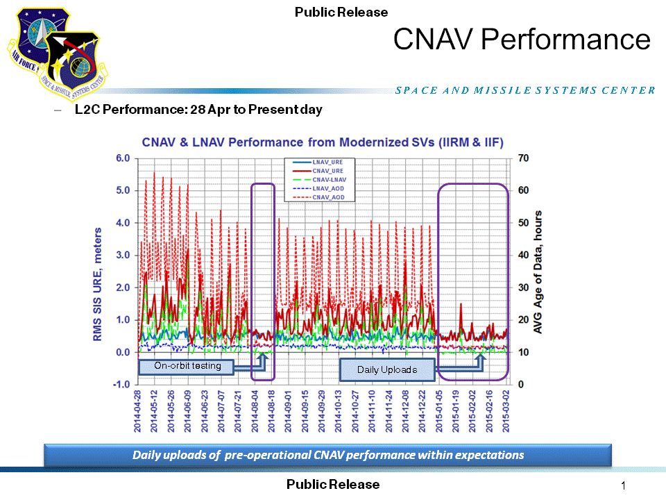
    “A Modernized Navigation (MODNAV) Tool integrated with the GPS ground control software (Architecture Evolution Plan or AEP) is generating the CNAV data messages,” Hamilton wrote. “Daily CNAV uploads began December 31, 2014, and the U.S. Air Force reports that signal performance of CNAV matches or slightly outperforms Legacy performance: average user range error (RMS URE) from 25 February – 3 March 2015 was 0.50 m for Legacy and 0.57 m for Modernized; best week for Modernized signals since the broadcast initiated April 2014 was 0.42 m for 6 – 13 January 2015.

    The graph above, from the Coast Guard Navigation Center website, illustrates the CNAV performance.

    Users are reminded that these CNAV signals are ‘pre-operational’ and should be used with discretion until they become fully operational; the L5 message is currently set unhealthy,” Hamilton concluded.

  • Fugro Offers High-Accuracy Offshore Positioning Service

    Fugro has introduced its high-accuracy G2+ service, designed to benefit offshore operators around the globe who require positioning and measurement accuracy at centimeter level.

    G2+ is an enhancement of Fugro’s G2 service (based on GPS and GLONASS). The service uses highly advanced GNSS augmentation algorithms developed in house. The code and carrier-phase signals transmitted by GPS and GLONASS satellites are monitored globally by Fugro’s worldwide network of reference stations.

    These observations are processed centrally in real-time using the company’s proprietary algorithms to generate precise corrections which are used to augment the standard signals broadcast by GPS and GLONASS satellites.

    Customers receive corrections via seven high-powered communications satellites, providing at least two independent G2+ data sources. The new satellite positioning service will be particularly beneficial when seeking to measure latitude, longitude, elevation and speed with high accuracy in real-time, Fugro said.

    Applications include offshore construction, survey services, vessel monitoring and structural monitoring. The ultra-high accuracy enables the real-time correction of tidal changes — which impact the accuracy of seabed mapping — as well as the real-time monitoring of the motion of floating and fixed structures.

    The 3D accuracies of the system approach those of GNSS RTK (real-time kinematic) systems while avoiding the need for an RTK base station or local transmission link, overcoming the logistical challenges and range limitations associated with coastal RTK systems, Fugro said.

    The launch of G2+ follows the recent launch of Fugro’s G4 satellite correction service, which takes advantage of all four global navigation satellite systems: GPS, GLONASS, BeiDou and Galileo.

  • Galileo at Your Service


    On the eve of the Galileo 7 and 8 launch, the European Space Agency has created a short video to explain the value of the satellite constellation to its citizens. With the Galileo System, Europe will provide a full range of services and applications across many different areas for Europe and beyond.

  • Rockwell to Provide Secure GPS Receivers for Harris Tactical Radios

    Rockwell to Provide Secure GPS Receivers for Harris Tactical Radios

    Rockwell Collins has signed a contract to provide its MicroGRAM GPS receivers (pictured here) for Harris Corporation’s tactical radios, bringing secure, jam-resistant GPS capability to products such as the Falcon III AN/PRC-158 and AN/PRC-117G.
    Rockwell Collins has signed a contract to provide its MicroGRAM GPS receivers (pictured here) for Harris Corporation’s tactical radios, bringing secure, jam-resistant GPS capability to products such as the Falcon III AN/PRC-158 and AN/PRC-117G.

    Rockwell Collins has signed a contract to provide its MicroGRAM GPS receivers for Harris Corporation’s tactical radios, bringing secure, jam-resistant GPS capability to products such as the Falcon III AN/PRC-158 and AN/PRC-117G.

    The contract, which represents the largest annual purchase of MicroGRAM, calls for Rockwell Collins to provide 5,000 GPS receivers to Harris over the next three years. Deliveries began in January.

    “MicroGRAM enables Harris Corporation to meet military customer demands for embedded, secure GPS,” said Mike Jones, vice president and general manager of Communication and Navigation Products for Rockwell Collins. “MicroGRAM protects warfighters from the growing jamming and spoofing threats on the battlefield, while enhancing survivability and mission success.”

    With this selection, Jones said Harris is one of the first major original equipment manufacturers to commit to using MicroGRAM to meet the Department of Defense’s (DoD) requirement to use Selective Availability/Anti-Spoofing Module (SAASM) technology in its products.

    “Harris is pleased to continue our long relationship with Rockwell Collins as our provider of GRAM SAASM GPS modules. Integrating the MicroGRAM receiver into a number of our new tactical radios allows us to reduce the size and weight while extending the battery life of our products,” said George Helm, president, Department of Defense business, Harris RF Communications. “The end result is delivering reliable situational awareness down to the individual warfighter.”

    MicroGRAM is the world’s smallest, lightest, lowest powered SAASM-based GPS receiver. It enables military micro-users who require secure Position, Navigation & Timing (PNT) to comply with U.S. DoD policy that all combat and combat support systems use SAASM-based GPS devices. This capability is critical at a time when threats to commercial GPS are increasing. The use of unprotected commercial non-SAASM GPS devices has inherent vulnerabilities which introduce a false sense of situational awareness on the battlefield.