Author: GPS World Staff

  • Drinking and Droning Has Consequences

    Drinking and Droning Has Consequences

    Firmware Fixes Coming from Phantom Maker DJI
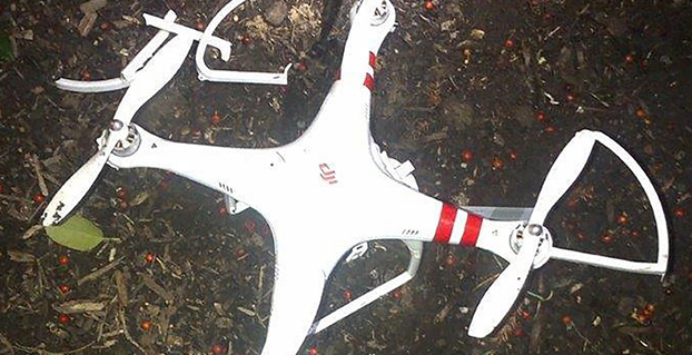
    A drone that crashed on the grounds of the White House had evaded radar detection. Photo: U.S. Secret Service
    The quadcopter that crashed on the White House lawn. Photo: U.S. Secret Service

    A government employee who crashed his friend’s drone on the White House lawn was apparently drinking while droning.

    The employee, who works for the National Geospatial-Intelligence Agency (NGA), was questioned Jan. 26 by the Secret Service as the operator of the drone involved in Monday’s incident at the White House. On Monday at 3 a.m., the drone quadcopter crashed on the White House lawn.

    The employee contacted authorities, according to the NGA. The employee was off duty and is not involved in work related to drones or unmanned aerial vehicles in any capacity at NGA, the agency said in a statement.

    “Even though the employee was using a personal item while off duty, the agency takes the incident very seriously and remains committed to promoting public trust and transparency,” the statement reads.

    The Secret Service is investigating the incident.

    Firmware to Force No-Fly Zone Compliance

    The drone is a Phantom made by Chinese company DJI. The company plans to roll out firmware within days to prevent any of its drones from flying over the D.C. area, in accordance with Federal Aviation Authority guidelines. This will help hobbyists who aren’t aware of or unable to comply with “no-fly zones,” such as the one that covers most of the D.C. area.

    Once updated, the DJI drones will not be able to take off from or fly into the nation’s capital or a 15-mile radius around it. GPS technology in the drones will be able to identify the no-fly zone, warn the operator and then stop at the no-fly zone’s border. DJI’s flight software currently prevents flights within a radius of major airports.

    “With the unmanned aerial systems community growing on a daily basis, we feel it is important to provide pilots additional tools to help them fly safely and responsibly,” said Michael Perry, DJI’s company spokesperson. “We will continue cooperating with regulators and lawmakers to ensure the skies stay safe and open for innovation.”

    The mandatory firmware update is for the Phantom 2, Phantom 2 Vision, and Phantom 2 Vision+ models. It adds a No-Fly Zone centered on downtown Washington, D.C., extending for a 15.5-mile radius in all directions. Phantom pilots in this area will not be able to take off from or fly into this airspace.

    “The restriction is part of a planned extension of DJI’s No Fly Zone system that prohibits flight near airports and other locations where flight is restricted by local authorities,” DJI said. “These extended no fly zones will include over 10,000 airports registered with the International Air Transport Association (IATA) and will expand no fly zones to ensure they cover the runways at major international airports.

    “DJI is also continuing to update its no-fly zone list in compliance with local regulations to include additional sensitive locations and to prevent flight across national borders. These new safety features will be released across DJI’s flying platforms in the near future.”
  • Rextorm Rugged Tablet Designed for Field Work

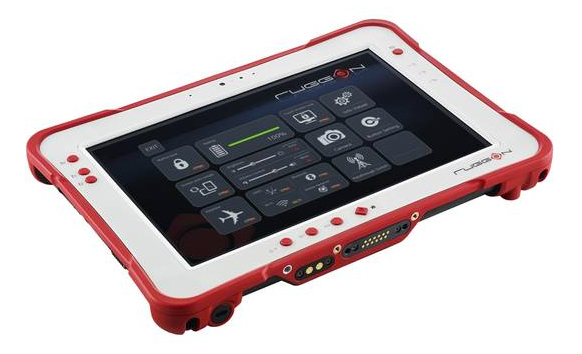
    RuggON-tablet
    Photo: RuggON 

    Taiwan-based company RuggON is launching the Rextorm series of rugged tablets. With an ultra-bright 1000 Nit optically bonded display, high speed 802.11ac connectivity, hot swappable dual-battery design, and capacitive glove touch capability, the 10.1-inch fully ruggedized tablets are ready for use in the field.

    With the latest communication technology including GNSS Positioning (GPS/GLONASS/Beidou), 802.11 ac, Bluetooth 4.0 and optional 4G LTE, mobile workers can experience precise positioning, fast processing, broad coverage and more stable data transfer even around buildings or trees, RuggON said. For in-vehicle usage, a dual pass-through port allows users to connect via vehicle dock for improved GNSS, WLAN, or WWAN reception. Standard I/O ports include USB 3.0, 2.0, RS232, RJ45, Micro-HDMI, and Micro-SD.

    The Rextorm series is a fully ruggedized tablet that meets and exceeds MIL-STD-810G standards for shock and vibration, offers IP65 rating, wide operating temperature range and superior drop resistance of 5 feet on to a concrete surface.

    Using the Intel Core i5 Haswell processor, the PX-501 has the fastest processor of the series and is a rugged workstation that can be taken to the field. High-capacity 120GB or 240GB SSDs are available, as well as 4GB or 8GB of DDR3 RAM. A precision digitizer allows accurate input for illustrations and technical work in the field. Windows 7/8 Pro as well as Windows Embedded 7/8 are available.


  • Telematics Detroit Changes Name to Reflect Shift to Autonomous Cars

    Telematics Detroit, the connected car event, has officially changed its name to TU-Automotive Detroit to reflect the paradigm shift in auto mobility. The event will take place June 3-4 at The Suburban Collection Showplace in Detroit.

    The name change to TU-Automotive Detroit is intended to reflect how “automakers are evolving from heavy manufacturers into nimble technology companies and the self-driving car is moving from the realms of science fiction onto the reality of our highways. The car as we know it is rapidly changing,” organizers said in a statement.

    Experts will provide overviews in three core areas of telematics, mobility and autonomous cars.

    “Anticipating the future trends of the automotive industry is exactly what this conference has always been about,” said Justin Parker, project director. “Accordingly, the new angle of the show addresses the headline topics of mobility and autonomous vehicles.”

    Key topics:

    • Telematics – the here and now: Consider the building blocks of the connected car that continue to present challenges and opportunities such as the ultimate user experience, the connected society and the aftermarket. It is these foundations that are paving the way for the future of auto-mobility.
    • Auto-mobility: The role of the car is changing. From new ownership models to sustainable transportation and smart cities, get to grips with the technology and societal changes that are fundamentally reshaping mobility.
    • The autonomous car: Sensors, lasers, ADAS and regulators. The end-goal of the self-driving car is an exciting amalgamation of regulatory and technological developments. We’re deep into the journey of the autonomous car and now is the time for the industry to come together to collectively take the next step.

    Get the latest updates and information and register for the brochure with full speaker line-up and agenda.


  • By 2020 Connected Cars Will Mean In-Vehicle Services, Automated Driving

    By 2020 a quarter billion connected vehicles will be on the road, enabling new in-vehicle services and automated driving capabilities, according to Gartner, Inc. During the next five years, the proportion of new vehicles equipped with this capability will increase dramatically, making connected cars a major element of the Internet of Things (IoT).

    Gartner forecasts that 4.9 billion connected things will be in use in 2015, up 30 percent from 2014, and will reach 25 billion by 2020.

    “The connected car is already a reality, and in-vehicle wireless connectivity is rapidly expanding from luxury models and premium brands to high-volume midmarket models,” said James F. Hines, research director at Gartner. “The increased consumption and creation of digital content within the vehicle will drive the need for more sophisticated infotainment systems, creating opportunities for application processors, graphics accelerators, displays and human-machine interface technologies. At the same time, new concepts of mobility and vehicle usage will lead to new business models and expansion of alternatives to car ownership, especially in urban environments.”

    Gartner forecasts that about one in five vehicles on the road worldwide will have some form of wireless network connection by 2020, amounting to more than 250 million connected vehicles. The proliferation of vehicle connectivity will have implications across the major functional areas of telematics, automated driving, infotainment and mobility services.

    More detailed analysis is available in the Gartner report “Predicts 2015: The Internet of Things.”

  • UBL Interactive Enters Data Agreement with NavAds for GPS Locations

    UBL Interactive, Inc. today announced a global data syndication agreement with Amsterdam-based NavAds to help businesses ensure their profiles appear in navigation services and devices.

    The NavAds agreement will improve the quality of the business listing information and the breadth of distribution for UBL customers. NavAds specializes in business listing insertion and advertising on navigation services such as TomTom, Garmin, Nokia HERE, Waze, Yandex, and others.

    UBL CEO, Doyal Bryant, said the partnership was significant not only because it addressed the growing use of mapping tools, but because it was a global arrangement. “UBL is focused on an increasingly mobile world, and services which are not confined by national borders. Navigation services are constantly changing and evolving and with our NavAds partnership, our customers can be assured anywhere globally, they will get the benefit of the most advanced distribution in the mapping space,” he said. “It extends our place as the global leader in business listing syndication, with more publishers and international local partnerships than any others in the space.”

    NavAds CEO, Lex ten Veen, said UBL would bring many new owner-verified business locations to the NavAds platform and network. “Businesses need to be found on these navigation devices, and NavAds can give UBL’s customers great confidence their visibility is fully optimized,” he said.

    The services will be integrated into UBL product sets immediately.

  • Trimble Unity Replaces Connect for Water, Wastewater and Stormwater Utilities

    Trimble Unity Replaces Connect for Water, Wastewater and Stormwater Utilities

    Trimble-unity-Hardware
    Photo: Trimble

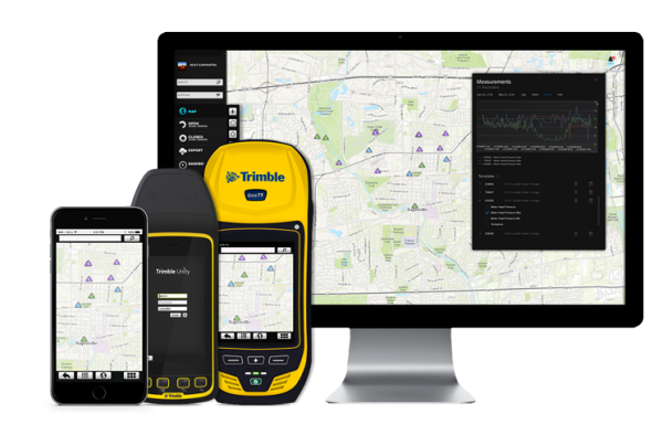
    Trimble introduced today its next generation suite of software applications for water, wastewater and stormwater utilities — Trimble Unity. Trimble Unity replaces Trimble Connect for Water and offers a unified cloud-based and mobile collaboration platform for smart water mapping and work management.

    Trimble Unity applications, or “apps,” support the following workflows:

    • Mapping: Field and office GIS visualization and mapping of assets with up to centimeter-level accuracies
    • Maintenance: GIS-based asset maintenance and inspection forms and business processes
    • Service: Customer field service work order and mobile workforce management
    • Metering: Smart water meter deployment, installation and maintenance
    • Monitoring: Visual and real-time monitoring of field operations and utility networks
    • Analytics: Dashboards and performance management reporting

    Trimble Unity represents a unified collaboration platform for managing critical utility assets and the work of water industry professionals. By integrating GIS and field operations, sensors and wireless communications, mobile workers and office professionals, field and back office enterprise systems, and utilities with their contractors, Trimble Unity provides the water industry with a comprehensive solution for regulatory reporting, improving operations, reducing cost and enhancing customer service, the company said.

    Trimble Unity is designed to automate a variety of industry workflows through individual “apps” offered within the software suite, enabling utilities to deploy smart meters, assess the condition of assets, repair leaks and reduce non-revenue water (NRW), and locate and map critical infrastructure using Trimble high-accuracy GNSS mapping technologies. The software can also assist utilities in reducing spills and environmental damage, extending the life of aging assets and helping improve worker safety and productivity.

    Through a Trimble Unity software-as-a-service (SaaS) subscription, organizations can provide a single solution for the office and the field, choosing any combination of Trimble and non-Trimble mobile devices, including iOS, Android, Windows Mobile and Windows 7/8 smartphone, tablets and laptops. The software also integrates the latest Esri ArcGIS Server, mobile and ArcGIS Online map services enabling organizations to leverage their existing investments in GIS technology.

  • Snowed in? Track Your City’s Snow Plows with GPS Apps

    Snowed in? Track Your City’s Snow Plows with GPS Apps

    PlowNYC-W
    Photo: PlowNYC

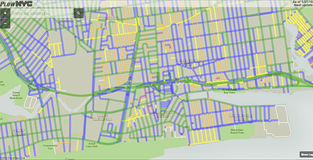
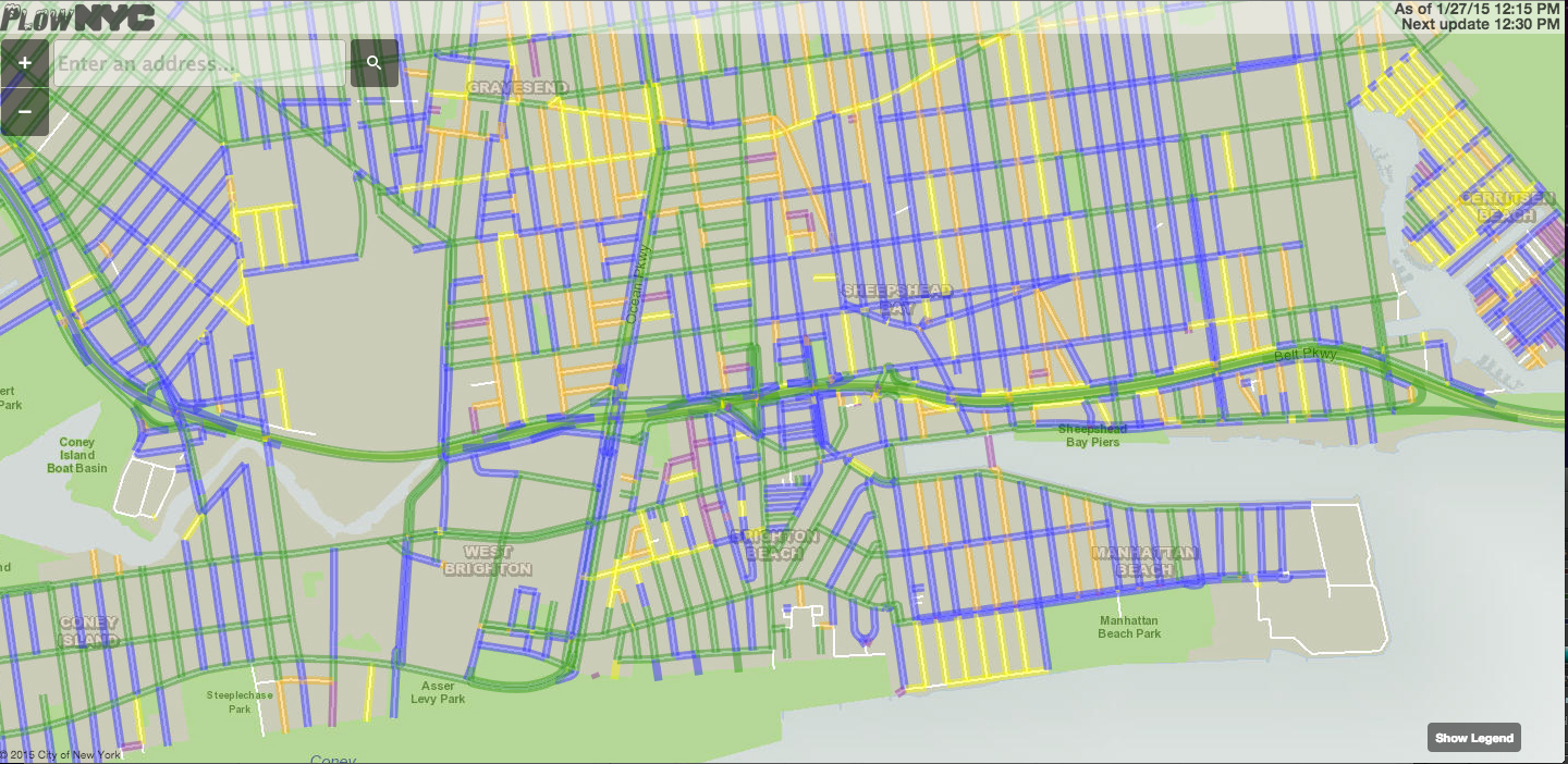
    Snow plows in many cities cleaning up the snow from a winter storm that blasted the Northeast are being tracked with GPS. One website application, PlowNYC, provides real-time updates on where the plows are in the Big Apple, according to CBS News. PlowNYC was developed by Rastrac, a GPS fleet tracking and remote asset management solution company.

    The New York City sanitation department is deploying 2,550 plows and more than 2,400 workers to combat the storm. “The city actually tracks all the snow plows and aggregates all of that information and make it available to New Yorkers on this map,” data scientist Ben Wellington told CBS News. “Green lines on the map show the roads that have been plowed in the last hour whereas the blue line shows the streets that have been plowed in the last one to three hours.”

    New York isn’t the only city applying this kind of technology. For the first time, Pittsburgh residents can track their plows in real time. Chicago has been sharing it’s plow data for the last several winters.

    “I think for the public, it gives them a sense of security to see where things are happening and feel like they can hold us accountable,” New York City sanitation commissioner Kathryn Garcia told CBS News. “At the end of the day, we work for them.” The apps also reduce the number of calls to city call centers.

  • Funding Proceeds for More GLONASS-K1 Satellites

    News courtesy of CANSPACE Listserv.

    According to its in-house newspaper, Siberian Satellite, the joint-stock company “Information Satellite Systems – Academician M.F. Reshetnev” has signed two loan agreements with the Russian VTB Bank (formerly Vneshtorgbank) worth 2.5 billion rubles ($38 million) to finance the production of GLONASS-K navigation satellites.

    Presumably, this refers to the decision to produce more GLONASS-K1 satellites as recently announced.

    The Russian government owns 61% of VTB.

  • LoJack, Novatel Wireless Join on Inventory Management for Auto Market

    LoJack Corporation is collaborating with Novatel Wireless to develop robust positioning and accuracy capabilities in the LoJack Connect for Inventory Management system. The system helps sales personnel at dealerships accurately track and actively monitor vehicle inventory across multiple lots, helping to minimize the time required in the regular dealer inventory process. Accessible via computer, tablet and mobile phone, users can verify vehicle location, access relevant vehicle information, track test drives and receive early warning alerts if a vehicle is moved from a geofenced location.

    LoJack Connect for Inventory Management is powered by the Novatel Wireless 3060 OBDII solution for HSDPA/GSM/GPRS. The MT 3060 is a specialized OBD II telematics solution that offers advanced technology and a sophisticated feature set, combined with high quality and compatibility testing standards, Novatel Wireless said. With dual accelerometers, GNSS support, an open platform, and the N4A Content Cloud Management System, the MT 3060 enables LoJack to offer a reliable telematics solution to dealerships nationwide.

    The system will be demonstrated in LoJack’s booth (#5058W) at the 2015 National Automotive Dealers Association (NADA) Convention & Exposition. It has been piloted at dealerships such as South Florida’s Braman Motorcars, and will be available in the second quarter of this year.

    [Editor’s note: Novatel Wireless has no connection with GPS/GNSS manufacturer NovAtel.  The two are separate, distinct companies.]

  • Topcon, Leica Sponsor REAL 2015 3D Sensor Conference

    REAL 2015: Capture, Compute, Create will be held Feb. 25–26 at Fort Mason Center in San Francisco. REAL is designed to explore the professional 3D sensing, creation, and visualization industries. It includes an executive summit and a world’s fair of cutting-edge 3D demonstrations, and is organized by Autodesk.

    According to organizers, “From drones to autonomous cars, industrial robots to major engineering works, and game consoles to tomorrow’s mobile phones, 3D sensors are suddenly everywhere. And several decades after first grabbing headlines, VR and 3D printing are hot again, attracting billions in investment, and moving beyond early adopters to professionals. But it is the sum total, where sensing meets making, where big change is brewing.”

    Sponsors include Leica Geosystems and Topcon. Two Topcon experts will speak at the event: Jason Hallett, Topcon vice president of global product management, and Eduardo Falcon, executive vice president and general manager of the GeoPositioning Solutions Group.

    “The Topcon line of advanced 3D imaging and mapping technologies are designed for a wide range of geospatial applications providing data-rich results,” Falcon said. “REAL 2015 presents opportunities to explore how our mobile and static scanning solutions can be utilized in forward-thinking ways, as 3D sensing and reality capture continue to permeate traditional and non-traditional industries alike.”


  • Drone Demonstrated for Congressional Science Committee

    The House Science, Space, and Technology Committee held a hearing Jan. 21 on the integration of commercial unmanned aerial vehicles in United States airspace. Colin Guinn, senior vice president of sales for 3D Robotics, demonstrated the Parrot Bebop drone during his testimony.

    C-SPAN aired the event, as reported by the National Journal. Congress has tasked the Federal Aviation Administration with readying airspace for the integration of commercial drones. Drones are currently prohibited for use, but the FAA has granted a growing number of exemptions for certain industries, including an exemption to GNSS company Trimble for its UX5 drone.

    Also, earlier this month, CNN signed a research agreement with regulators to test drone systems for news-gathering purposes.

    Meanwhile, a hobbyist crashed his UAV on the White House lawn early this morning.

  • New Apps, Wearable Aimed at Personal Safety

    New Apps, Wearable Aimed at Personal Safety

    Two new products have found ways to turn smartphones into personal protection devices. One of the two products includes a wearable monitor.

    5-in-1+ways+to+wear Photo: First Sign Technologies
    Photo: First Sign Technologies

    Mace Wear Pod

    The Mace Wear Pod uses a wearable device in conjunction with a smartphone app. First Sign Technologies, in partnership with Mace Wear, has launched the Mace Wear Pod, which acts as a personal security system against violent crimes. At the first sign of a violent attack, an assault alarm is activated and the speaker lets the attacker know that evidence has been collected and help is on the way. The device automatically begins to collect evidence, take photos, and call for help, which will help identify, apprehend, prosecute and deter attackers, the makers say.

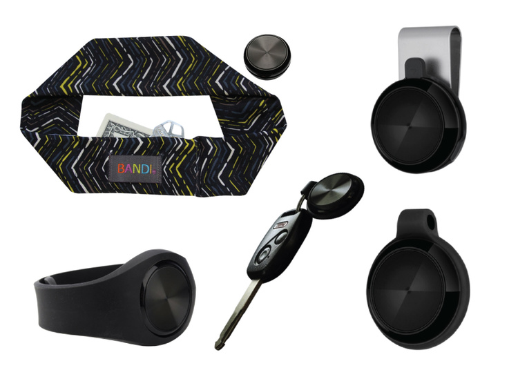
    The Mace Wear Pod can be worn in five ways as a headband, wristband, key chain, belt clip and pendant. For those not wearing the pod, the mobile app, which can be downloaded on iPhone and Android, can also be activated in three ways, by hitting the alert button, by shaking your phone, or by setting a time to check-in — the alarm is activated if the check in doesn’t take place.

    First Sign Technologies was launched in January 2014.  Following a successful crowd-funding campaign, the product is now available with one year of monitoring service for $120.

    “There is a demand for personal protection and with the advances in wearable technology, we want to create products that give peace of mind,” said First Sign President Rachel Emanuele. “Mace is an ideal partner to help us expand our product line and help promote safety to all who seek it.”

    The products are expected to be available in more than 1,000 stores such as Dick’s Sporting Goods, Sports Authority and Sears. Demonstration videos are posted here.

    STOP-ATTACK
    Photo: STOP-ATTACK

    STOP-ATTACK

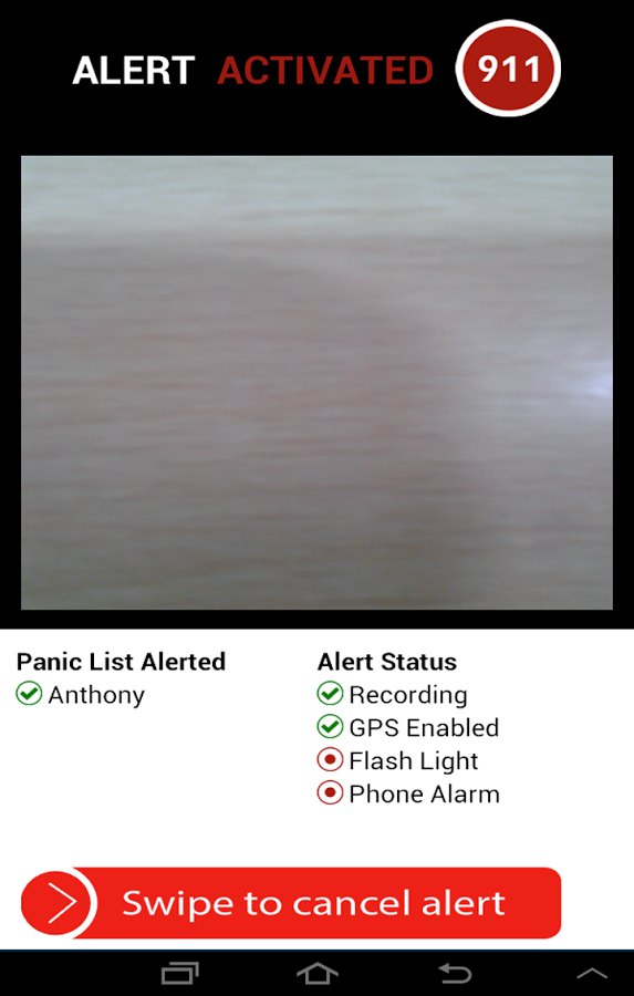
    Another new app launching this month, STOP-ATTACK, uses smartphone technology to send alerts in case of bullying or harassment. STOP-ATTACK, available on both Android and Apple platforms, records audio and video evidence and alerts contacts of trouble in a matter of seconds, sending GPS coordinates to a designated Panic List and first responders.

    “We need to stop the senseless violence and assaults in this world,” said Anthony “Tony” Bright, the creator of STOP-ATTACK. “Our hope is that STOP-ATTACK.com will be a powerful tool in this struggle. The app has been developed with simplicity as a core feature, so that even younger children can be protected, giving parents much-needed peace of mind.” The CEO will be presenting the STOP-ATTACK app at the Pre-Grammy Awards VIP Gift Lounge and The Oscars Gift Lounge hosted by GBK productions this February.

    The app can be downloaded in the Google Play or iTunes store, and is available for free now until Feb. 8, 2015.

    STOP-ATTACK users will be able to customize many aspects of the app, such as creating a “Panic List” of people for the app to contact in an emergency, from friends and family to local first responders. When a user activates STOP-ATTACK, the app instantly begins recording live audio and video and uploading the stream to the cloud. Panic List contacts and designated first responders are notified immediately or after a brief, user-determined delay. The app will send the contacts a link with the GPS location and the recording of the incident.

    A hot key allows for quick and discrete activation of the STOP-ATTACK app. For instance, a bully need not know they’re being recorded until presented with the evidence by a school authority. On the other hand, it’s sometimes advantageous to let everyone know that STOP-ATTACK is recording; users can choose for the app to play an alarm sound and turn on the camera light when activated, a strong deterrent to a would-be attacker.

    The developers of STOP-ATTACK have created a pair of explainer videos to showcase exactly how the app works in typical usage scenarios: “Always Be Prepared,” “Bullying.”